Bridge Statistics for Hyde Park, Pennsylvania (PA)
Condition, Traffic, Stress, Structural Evaluation, Project Costs
- National Bridge Inventory (NBI) Statistics
- 11Number of bridges
- 115ft / 34.8mTotal length
- $957,000Total costs
- 117,345Total average daily traffic
- 6,013Total average daily truck traffic
- National Bridge Inventory (NBI) Registered Bridges for Hyde Park
- No street view available for this location
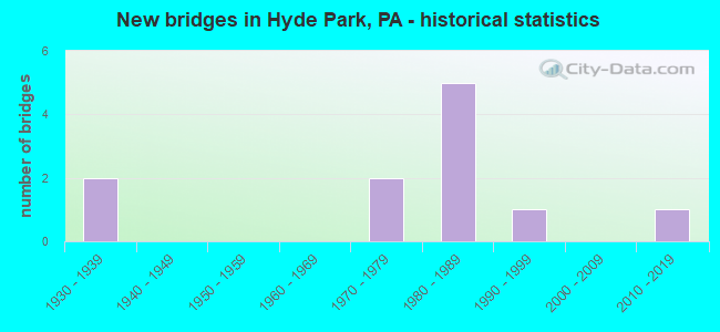
- New bridges - historical statistics
- 21930-1939
- 21970-1979
- 51980-1989
- 11990-1999
- 12010-2019


- Bridge Condition - Deck
- 14.3%Very good
- 28.6%Good
- 28.6%Satisfactory
- 14.3%Fair
- 14.3%Poor

- Bridge Condition - Superstructure
- 14.3%Excellent
- 42.9%Good
- 14.3%Satisfactory
- 14.3%Fair
- 14.3%Poor

- Bridge Condition - Substructure
- 14.3%Very good
- 14.3%Good
- 14.3%Satisfactory
- 57.1%Fair

- Bridge Condition - Channel
- 25.0%Satisfactory
- 25.0%Fair
- 50.0%Poor
Find on map >> Show street view
Structure Number: 3251, Location: HUNGRY HOLLOW NO.3 (Lat: 40.646992, Lng: -79.565339), Route carried "on" structure: State highway , Year Built: 1938, Status: Open, Structure Length: 1.07m (3.51ft), Average Daily Traffic: 90 (year 2021), Truck Traffic: 9%, Average Future Daily Traffic: 275 (year 2032), Design Load: H 20, Features Intersected: GUFFY RUN, Facility Carried by Structure: SR2059
Minimum Vertical Clearance: 30+ m (98+ ft), Kilometerpoint: 1.822, Lanes on structure: 2, Owner: State Highway Agency, Approaching Roadway Width: 5.5m (18.0ft), Skew: 3 degrees, Material/Design: Concrete, Design/Construction: Tee Beam, Number Of Spans In Main Unit: 1, Length of Maximum Span: 10.1m (33.1ft), Curb or Sidewalk Widths: Left: 0.2m (0.7ft), Right: 0.2m (0.7ft), Curb-To-Curb Width: 6.9m (22.6ft), Out-to-Out Width: 7.9m (25.9ft)
Condition: Deck: Fair, Superstructure: Fair, Substructure: Fair, Channel: Poor, Operating Rating: 68.9 metric tons, Method Used To Determine Operating Rating: Load Factor (LF), Inventory Rating: 41.7 metric tons, Method Used To Determine Inventory Rating: Load Factor (LF), Structural Evaluation: Somewhat better than minimum adequacy, Deck Geometry: Somewhat better than minimum adequacy, Waterway Adequacy: Better than present minimum criteria, Approach Roadway Alignment: Better than present minimum criteria, Length Of Structure Improvement: 1.10m (3.61ft), Designated Inspection Frequency: Every 24 months, Inspection Date: August 2020, Bridge Improvement Cost: $19,000, Roadway Improvement Cost: $83,000, Total Project Cost: $252,000, Deck Structure Type: Concrete Cast-file-Place, Wearing Surface/Protective System: Wearing Surface: Bituminous
Find on map >> Show street view
Structure Number: 3252, Location: HUNGRY HOLLOW NO.4 (Lat: 40.651628, Lng: -79.561489), Route carried "on" structure: State highway , Year Built: 1938, Status: Open, Structure Length: 1.01m (3.31ft), Average Daily Traffic: 90 (year 2021), Truck Traffic: 9%, Average Future Daily Traffic: 275 (year 2032), Design Load: H 20, Features Intersected: GUFFY RUN, Facility Carried by Structure: SR2059
Minimum Vertical Clearance: 30+ m (98+ ft), Kilometerpoint: 2.556, Lanes on structure: 2, Owner: State Highway Agency, Approaching Roadway Width: 4.9m (16.1ft), Skew: 4 degrees, Material/Design: Concrete, Design/Construction: Tee Beam, Number Of Spans In Main Unit: 1, Length of Maximum Span: 9.4m (30.8ft), Curb or Sidewalk Widths: Left: 0.2m (0.7ft), Right: 0.2m (0.7ft), Curb-To-Curb Width: 6.9m (22.6ft), Out-to-Out Width: 7.9m (25.9ft)
Condition: Deck: Poor, Superstructure: Poor, Substructure: Fair, Channel: Poor, Operating Rating: 53.5 metric tons, Method Used To Determine Operating Rating: Load Factor (LF), Inventory Rating: 31.8 metric tons, Method Used To Determine Inventory Rating: Load Factor (LF), Structural Evaluation: Meets minimum limits, Deck Geometry: Somewhat better than minimum adequacy, Waterway Adequacy: Better than present minimum criteria, Approach Roadway Alignment: Better than present minimum criteria, Length Of Structure Improvement: 1.00m (3.28ft), Designated Inspection Frequency: Every 24 months, Inspection Date: August 2020, Bridge Improvement Cost: $18,000, Roadway Improvement Cost: $84,000, Total Project Cost: $243,000, Deck Structure Type: Concrete Cast-file-Place, Wearing Surface/Protective System: Wearing Surface: Bituminous
Find on map >> Show street view
Structure Number: 4787, Location: FIFTH ST.HIGHWAY (Lat: 40.371778, Lng: -75.926575), Route carried "on" structure: Business US 222B, Year Built: 1980, Status: Open, Structure Length: 6.74m (22.11ft), Average Daily Traffic: 23,377 (year 2022), Truck Traffic: 6%, Average Future Daily Traffic: 29,175 (year 2032), Design Load: HS 20, Features Intersected: PA 12 (LR 784)
Minimum Vertical Clearance: 30+ m (98+ ft), Kilometerpoint: 5.557, Lanes on structure: 6, Lanes under structure: 12, Base Highway Network: Yes, Owner: State Highway Agency, Approaching Roadway Width: 30.5m (100.1ft), Skew: 32 degrees, Material/Design: Steel, Design/Construction: Stringer/Multi-beam, Number Of Spans In Main Unit: 1, Number Of Approach Spans: 2, Length of Maximum Span: 41.1m (134.8ft), Curb or Sidewalk Widths: Left: 0.2m (0.7ft), Right: 0.2m (0.7ft), Curb-To-Curb Width: 29.3m (96.1ft), Out-to-Out Width: 30.5m (100.1ft)
Condition: Deck: Satisfactory, Superstructure: Satisfactory, Substructure: Satisfactory, Operating Rating: 78.0 metric tons, Method Used To Determine Operating Rating: Load Factor (LF), Inventory Rating: 46.3 metric tons, Method Used To Determine Inventory Rating: Load Factor (LF), Structural Evaluation: Equal to present minimum criteria, Deck Geometry: Superior to present desirable criteria, Underclear: High priority of corrective action, Approach Roadway Alignment: Equal to present desirable criteria, Length Of Structure Improvement: 7.70m (25.26ft), Designated Inspection Frequency: Every 24 months, Inspection Date: August 2020, Bridge Improvement Cost: $34,000, Roadway Improvement Cost: $101,000, Total Project Cost: $462,000, Deck Structure Type: Concrete Cast-file-Place, Wearing Surface/Protective System: Wearing Surface: Monolithic Concrete, Deck Protection: Epoxy Coated Reinforcing
Find on map >> Show street view
Structure Number: 5045, Location: 11TH ST.OVER T-413 (Lat: 40.375069, Lng: -75.917656), Route carried "on" structure: State highway , Year Built: 1978, Status: Open, Structure Length: 5.15m (16.90ft), Average Daily Traffic: 8,294 (year 2022), Truck Traffic: 3%, Average Future Daily Traffic: 12,982 (year 2032), Design Load: HS 20, Features Intersected: T-413(SPRING VALLEY RD.), Facility Carried by Structure: SR 2011 (11TH ST.)
Minimum Vertical Clearance: 30+ m (98+ ft), Kilometerpoint: 1.886, Lanes on structure: 2, Lanes under structure: 2, Owner: State Highway Agency, Approaching Roadway Width: 17.4m (57.1ft), Skew: 2 degrees, Material/Design: Prestressed concrete, Design/Construction: Stringer/Multi-beam, Number Of Spans In Main Unit: 3, Length of Maximum Span: 30.2m (99.1ft), Curb-To-Curb Width: 13.4m (44.0ft), Out-to-Out Width: 14.6m (47.9ft)
Condition: Deck: Good, Superstructure: Good, Substructure: Fair, Operating Rating: 82.6 metric tons, Method Used To Determine Operating Rating: Load Factor (LF), Inventory Rating: 26.3 metric tons, Method Used To Determine Inventory Rating: Load Factor (LF), Structural Evaluation: Somewhat better than minimum adequacy, Deck Geometry: Equal to present minimum criteria, Underclear: Somewhat better than minimum adequacy, Approach Roadway Alignment: Equal to present desirable criteria, Length Of Structure Improvement: 6.10m (20.01ft), Designated Inspection Frequency: Every 24 months, Inspection Date: October 2020, Deck Structure Type: Concrete Cast-file-Place, Wearing Surface/Protective System: Wearing Surface: Epoxy Overlay, Deck Protection: Epoxy Coated Reinforcing
Find on map >> Show street view
Structure Number: 5075, Location: 0.25 MI.E.OF READING (Lat: 40.371481, Lng: -75.919733), Route carried "on" structure: State highway 12, Year Built: 1980, Status: Open, Structure Length: 13.93m (45.70ft), Average Daily Traffic: 31,911 (year 2020), Truck Traffic: 5%, Average Future Daily Traffic: 43,131 (year 2032), Design Load: HS 20, Features Intersected: SR 2007,BERNHART CREEK
Minimum Vertical Clearance: 30+ m (98+ ft), Kilometerpoint: 4.255, Lanes on structure: 6, Lanes under structure: 2, Base Highway Network: Yes, Owner: State Highway Agency, Approaching Roadway Width: 31.7m (104.0ft), Skew: 39 degrees, Material/Design: Prestressed concrete, Design/Construction: Stringer/Multi-beam, Number Of Spans In Main Unit: 7, Length of Maximum Span: 26.5m (86.9ft), Curb-To-Curb Width: 30.5m (100.1ft), Out-to-Out Width: 32.3m (106.0ft)
Condition: Deck: Satisfactory, Superstructure: Good, Substructure: Fair, Channel: Satisfactory, Operating Rating: 76.2 metric tons, Method Used To Determine Operating Rating: Load Factor (LF), Inventory Rating: 33.6 metric tons, Method Used To Determine Inventory Rating: Load Factor (LF), Structural Evaluation: Somewhat better than minimum adequacy, Deck Geometry: Superior to present desirable criteria, Underclear: Better than present minimum criteria, Waterway Adequacy: Superior to present desirable criteria, Approach Roadway Alignment: Equal to present desirable criteria, Length Of Structure Improvement: 15.70m (51.51ft), Designated Inspection Frequency: Every 24 months, Inspection Date: October 2020, Deck Structure Type: Concrete Cast-file-Place, Wearing Surface/Protective System: Wearing Surface: Monolithic Concrete, Deck Protection: Epoxy Coated Reinforcing
Find on map >> Show street view
Structure Number: 5303, Location: GEORGE ST.MUHLENBURG TWP. (Lat: 40.375944, Lng: -75.932747), Route carried "on" structure: City street , Year Built: 1991, Status: Open, Structure Length: 4.08m (13.39ft), Average Daily Traffic: 2,000 (year 1990), Truck Traffic: 10%, Average Future Daily Traffic: 3,500 (year 2030), Design Load: HS 25 or greater, Features Intersected: NORFOLK SOUTHERN RR, Facility Carried by Structure: GEORGE ST
Minimum Vertical Clearance: 30+ m (98+ ft), Kilometerpoint: 0.000, Lanes on structure: 2, Owner: Town or Township Highway Agency, Approaching Roadway Width: 8.8m (28.9ft), Material/Design: Steel, Design/Construction: Girder and Floorbeam System, Number Of Spans In Main Unit: 1, Length of Maximum Span: 39.6m (129.9ft), Curb or Sidewalk Widths: Left: 0.2m (0.7ft), Right: 1.8m (5.9ft), Curb-To-Curb Width: 9.1m (29.9ft), Out-to-Out Width: 9.1m (29.9ft)
Condition: Deck: Good, Superstructure: Good, Substructure: Good, Operating Rating: 66.2 metric tons, Method Used To Determine Operating Rating: Load Factor (LF), Inventory Rating: 39.9 metric tons, Method Used To Determine Inventory Rating: Load Factor (LF), Structural Evaluation: Better than present minimum criteria, Deck Geometry: Somewhat better than minimum adequacy, Underclear: High priority of corrective action, Approach Roadway Alignment: Somewhat better than minimum adequacy, Length Of Structure Improvement: 4.90m (16.08ft), Designated Inspection Frequency: Every 24 months, Critical Feature Inspection Frequency: Every 24 months, Inspection Date: November 2020, Critical Feature Inspection Date: November 2020, Deck Structure Type: Concrete Cast-file-Place, Wearing Surface/Protective System: Wearing Surface: Monolithic Concrete, Deck Protection: Epoxy Coated Reinforcing
Find on map >> Show street view
Structure Number: 545, Location: 0.2 Mi S SR 2059 Inter. (Lat: 40.633333, Lng: -79.581611), Route carried "on" structure: State highway 66, Year Built: 2017, Status: Open, Structure Length: 2.77m (9.09ft), Average Daily Traffic: 2,349 (year 2021), Truck Traffic: 7%, Average Future Daily Traffic: 3,767 (year 2032), Design Load: HL 93, Features Intersected: GUFFY RUN
Minimum Vertical Clearance: 30+ m (98+ ft), Kilometerpoint: 5.625, Lanes on structure: 2, Base Highway Network: Yes, Owner: State Highway Agency, Approaching Roadway Width: 9.8m (32.2ft), Material/Design: Prestressed concrete, Design/Construction: Stringer/Multi-beam, Number Of Spans In Main Unit: 1, Length of Maximum Span: 26.8m (87.9ft), Curb or Sidewalk Widths: Left: 0.2m (0.7ft), Right: 0.2m (0.7ft), Curb-To-Curb Width: 11.0m (36.1ft), Out-to-Out Width: 12.0m (39.4ft)
Condition: Deck: Very good, Superstructure: Excellent, Substructure: Very good, Channel: Fair, Operating Rating: 54.4 metric tons, Method Used To Determine Operating Rating: Assigned ratings based on Load and Resistance Factor Design (LRFD) reported by rating factor (RF) using HL93 loadings, Inventory Rating: 40.2 metric tons, Method Used To Determine Inventory Rating: Assigned ratings based on Load and Resistance Factor Design (LRFD) reported by rating factor (RF) using HL93 loadings, Structural Evaluation: Equal to present desirable criteria, Deck Geometry: Somewhat better than minimum adequacy, Waterway Adequacy: Equal to present minimum criteria, Approach Roadway Alignment: Better than present minimum criteria, Designated Inspection Frequency: Every 48 months, Inspection Date: August 2021, Deck Structure Type: Concrete Cast-file-Place, Wearing Surface/Protective System: Wearing Surface: Monolithic Concrete, Deck Protection: Epoxy Coated Reinforcing
Find on map >> Show street view
Structure Number: 4787, Location: FIFTH ST.HIGHWAY (Lat: 40.371778, Lng: -75.926575), Route carried "under" structure: State highway 12, Year Built: 1980, Structure Length: 0. m, Average Daily Traffic: 23,852 (year 2022), Truck Traffic: 5%, Features Intersected: PA 12 (LR 784), Facility Carried by Structure: US 222B(LR 157)5TH
Minimum Vertical Clearance: 5.67m (18.60ft), Kilometerpoint: 3.703, Lanes on structure: 6, Lanes under structure: 6, Material/Design: Steel, Design/Construction: Stringer/Multi-beam, Length of Maximum Span: 41.1m (134.8ft)
Find on map >> Show street view
Structure Number: 4787, Location: FIFTH ST.HIGHWAY (Lat: 40.371778, Lng: -75.926575), Route carried "under" structure: State highway 12, Year Built: 1980, Structure Length: 0. m, Average Daily Traffic: 15,832 (year 2020), Truck Traffic: 6%, Features Intersected: PA 12 (LR 784), Facility Carried by Structure: US 222B(LR 157)5TH
Minimum Vertical Clearance: 4.82m (15.81ft), Kilometerpoint: 3.703, Lanes on structure: 6, Lanes under structure: 6, Material/Design: Steel, Design/Construction: Stringer/Multi-beam, Length of Maximum Span: 41.1m (134.8ft)
Find on map >> Show street view
Structure Number: 5045, Location: 11TH ST.OVER T-413 (Lat: 40.375069, Lng: -75.917656), Route carried "under" structure: City street , Year Built: 1978, Structure Length: 0. m, Average Daily Traffic: 1,890 (year 1994), Truck Traffic: 1%, Features Intersected: T-413(SPRING VALLEY RD.), Facility Carried by Structure: SR 2011 (11TH ST.)
Minimum Vertical Clearance: 4.48m (14.70ft), Kilometerpoint: 0.000, Lanes on structure: 2, Lanes under structure: 2, Material/Design: Prestressed concrete, Design/Construction: Stringer/Multi-beam, Length of Maximum Span: 30.2m (99.1ft)
Find on map >> Show street view
Structure Number: 5075, Location: 0.25 MI.E.OF READING (Lat: 40.371481, Lng: -75.919733), Route carried "under" structure: State highway , Year Built: 1980, Structure Length: 0. m, Average Daily Traffic: 7,660 (year 2021), Truck Traffic: 3%, Features Intersected: SR 2007,BERNHART CREEK, Facility Carried by Structure: PA 12
Minimum Vertical Clearance: 11.44m (37.53ft), Kilometerpoint: 4.498, Lanes on structure: 6, Lanes under structure: 2, Material/Design: Prestressed concrete, Design/Construction: Stringer/Multi-beam, Length of Maximum Span: 26.5m (86.9ft)