Bridge Statistics for Hutchins, Texas (TX)
Condition, Traffic, Stress, Structural Evaluation, Project Costs
- National Bridge Inventory (NBI) Statistics
- 34Number of bridges
- 883ft / 269mTotal length
- 1,138,041Total average daily traffic
- 191,946Total average daily truck traffic
- National Bridge Inventory (NBI) Registered Bridges for Hutchins
- No street view available for this location
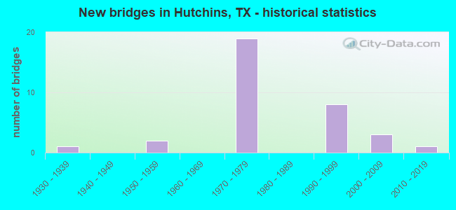
- New bridges - historical statistics
- 11930-1939
- 21950-1959
- 191970-1979
- 81990-1999
- 32000-2009
- 12010-2019
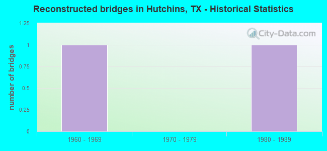
- Reconstructed bridges - Historical Statistics
- 11960-1969
- 01970-1979
- 11980-1989
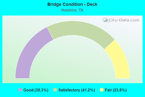
- Bridge Condition - Deck
- 35.3%Good
- 41.2%Satisfactory
- 23.5%Fair
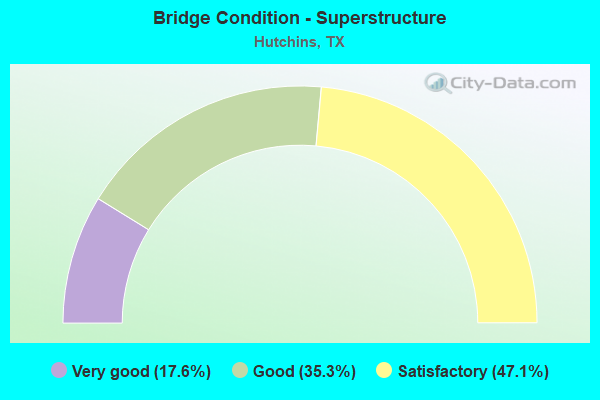
- Bridge Condition - Superstructure
- 17.6%Very good
- 35.3%Good
- 47.1%Satisfactory
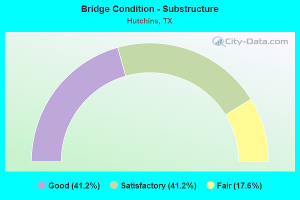
- Bridge Condition - Substructure
- 41.2%Good
- 41.2%Satisfactory
- 17.6%Fair
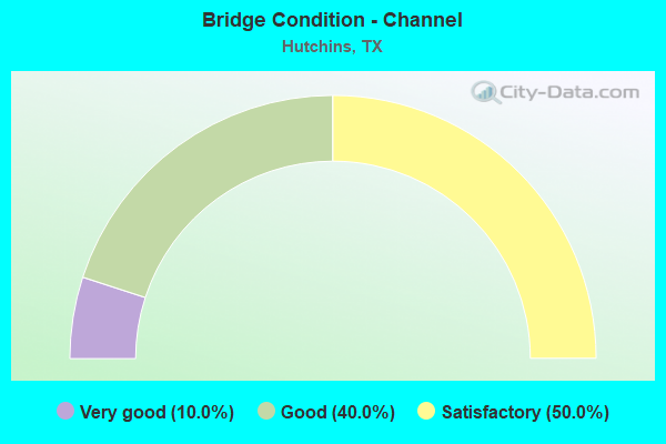
- Bridge Condition - Channel
- 10.0%Very good
- 40.0%Good
- 50.0%Satisfactory
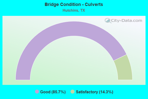
- Bridge Condition - Culverts
- 85.7%Good
- 14.3%Satisfactory
Find on map >> Show street view
Structure Number: 180570009202063, Location: 0.75 MI S OF IH 20 (Lat: 32.655817, Lng: -96.716314), Route carried "on" structure: Interstate 45, Year Built: 1954, Year Reconstructed: 1973, Status: Open, Structure Length: 15.85m (52.00ft), Average Daily Traffic: 68,837 (year 2020), Truck Traffic: 19%, Average Future Daily Traffic: 70,950 (year 2035), Design Load: H 20, Features Intersected: UP RR & MILLER FERRY RD
Minimum Vertical Clearance: 30+ m (98+ ft), Kilometerpoint: 13.255, Lanes on structure: 7, Lanes under structure: 4, Owner: State Highway Agency, Approaching Roadway Width: 35.4m (116.1ft), Skew: 39 degrees, Material/Design: Steel continuous, Design/Construction: Stringer/Multi-beam, Number Of Spans In Main Unit: 7, Number Of Approach Spans: 2, Length of Maximum Span: 20.4m (66.9ft), Curb-To-Curb Width: 35.6m (116.8ft), Out-to-Out Width: 37.1m (121.7ft)
Condition: Deck: Fair, Superstructure: Satisfactory, Substructure: Satisfactory, Operating Rating: 64.6 metric tons, Method Used To Determine Operating Rating: Load Factor (LF), Inventory Rating: 38.5 metric tons, Method Used To Determine Inventory Rating: Load Factor (LF), Structural Evaluation: Equal to present minimum criteria, Deck Geometry: Superior to present desirable criteria, Underclear: Meets minimum limits, Approach Roadway Alignment: Equal to present desirable criteria, Designated Inspection Frequency: Every 24 months, Critical Feature Inspection Frequency: Every 24 months, Inspection Date: March 2020, Critical Feature Inspection Date: May 2021, Deck Structure Type: Concrete Cast-file-Place
Find on map >> Show street view
Structure Number: 180570009202341, Location: 3.50 MI S OF IH 20 (Lat: 32.621883, Lng: -96.694986), Route carried "on" structure: City street , Year Built: 1999, Status: Open, Structure Length: 14.63m (48.00ft), Average Daily Traffic: 3,500 (year 2015), Truck Traffic: 10%, Average Future Daily Traffic: 6,300 (year 2035), Design Load: HS 20, Features Intersected: IH 45, Facility Carried by Structure: FULGHUM RD
Minimum Vertical Clearance: 30+ m (98+ ft), Kilometerpoint: 1.046, Lanes on structure: 2, Lanes under structure: 14, Owner: State Highway Agency, Approaching Roadway Width: 13.4m (44.0ft), Material/Design: Prestressed concrete, Design/Construction: Stringer/Multi-beam, Number Of Spans In Main Unit: 4, Number Of Approach Spans: 2, Length of Maximum Span: 27.4m (89.9ft), Curb-To-Curb Width: 13.2m (43.3ft), Out-to-Out Width: 14.0m (45.9ft)
Condition: Deck: Good, Superstructure: Very good, Substructure: Good, Operating Rating: 54.4 metric tons, Method Used To Determine Operating Rating: Assigned rating based on Load Factor Design (LFD) reported in metric tons, Inventory Rating: 32.7 metric tons, Method Used To Determine Inventory Rating: Assigned rating based on Load Factor Design (LFD) reported in metric tons, Structural Evaluation: Better than present minimum criteria, Deck Geometry: Equal to present minimum criteria, Underclear: Equal to present minimum criteria, Approach Roadway Alignment: Equal to present desirable criteria, Designated Inspection Frequency: Every 24 months, Inspection Date: Febuary 2020, Deck Structure Type: Concrete Precast Panels
Find on map >> Show street view
Structure Number: 180570009202342, Location: 2.10 MI S OF IH 20 (Lat: 32.632189, Lng: -96.699981), Route carried "on" structure: City street 8256, Year Built: 1999, Status: Open, Structure Length: 12.80m (41.99ft), Average Daily Traffic: 5,100 (year 2015), Truck Traffic: 5%, Average Future Daily Traffic: 10,000 (year 2035), Design Load: HS 20, Features Intersected: IH 45, Facility Carried by Structure: WINTERGREEN RD
Minimum Vertical Clearance: 30+ m (98+ ft), Kilometerpoint: 24.784, Lanes on structure: 2, Lanes under structure: 10, Owner: State Highway Agency, Approaching Roadway Width: 13.4m (44.0ft), Material/Design: Prestressed concrete, Design/Construction: Stringer/Multi-beam, Number Of Spans In Main Unit: 4, Number Of Approach Spans: 2, Length of Maximum Span: 25.9m (85.0ft), Curb-To-Curb Width: 13.2m (43.3ft), Out-to-Out Width: 14.0m (45.9ft)
Condition: Deck: Good, Superstructure: Good, Substructure: Good, Operating Rating: 54.4 metric tons, Method Used To Determine Operating Rating: Assigned rating based on Load Factor Design (LFD) reported in metric tons, Inventory Rating: 32.7 metric tons, Method Used To Determine Inventory Rating: Assigned rating based on Load Factor Design (LFD) reported in metric tons, Structural Evaluation: Better than present minimum criteria, Deck Geometry: Somewhat better than minimum adequacy, Underclear: Equal to present minimum criteria, Approach Roadway Alignment: Equal to present desirable criteria, Designated Inspection Frequency: Every 24 months, Inspection Date: Febuary 2020, Deck Structure Type: Concrete Precast Panels
Find on map >> Show street view
Structure Number: 180570009202343, Location: 1.50 MI S OF IH 20 (Lat: 32.648758, Lng: -96.707281), Route carried "on" structure: Interstate 45, Year Built: 1999, Status: Open, Structure Length: 7.32m (24.02ft), Average Daily Traffic: 69,167 (year 2020), Truck Traffic: 20%, Average Future Daily Traffic: 76,030 (year 2035), Design Load: HS 20, Features Intersected: DOWDY FERRY RD
Minimum Vertical Clearance: 30+ m (98+ ft), Kilometerpoint: 12.241, Lanes on structure: 6, Lanes under structure: 4, Owner: State Highway Agency, Approaching Roadway Width: 35.4m (116.1ft), Skew: 30 degrees, Material/Design: Prestressed concrete, Design/Construction: Stringer/Multi-beam, Number Of Spans In Main Unit: 3, Length of Maximum Span: 24.4m (80.1ft), Curb-To-Curb Width: 35.8m (117.5ft), Out-to-Out Width: 37.2m (122.0ft)
Condition: Deck: Good, Superstructure: Good, Substructure: Good, Operating Rating: 54.4 metric tons, Method Used To Determine Operating Rating: Assigned rating based on Load Factor Design (LFD) reported in metric tons, Inventory Rating: 32.7 metric tons, Method Used To Determine Inventory Rating: Assigned rating based on Load Factor Design (LFD) reported in metric tons, Structural Evaluation: Better than present minimum criteria, Deck Geometry: Superior to present desirable criteria, Underclear: Meets minimum limits, Approach Roadway Alignment: Equal to present desirable criteria, Designated Inspection Frequency: Every 24 months, Inspection Date: Febuary 2020, Deck Structure Type: Concrete Precast Panels
Find on map >> Show street view
Structure Number: 180570009214212, Location: 0.15 Mi S of IH 20 (Lat: 32.660081, Lng: -96.725172), Route carried "on" structure: City street , Year Built: 1973, Status: Open, Structure Length: 9.39m (30.81ft), Average Daily Traffic: 9,449 (year 2019), Truck Traffic: 3%, Average Future Daily Traffic: 13,229 (year 2040), Design Load: H 20, Features Intersected: IH 45, Facility Carried by Structure: Langdon Rd
Minimum Vertical Clearance: 30+ m (98+ ft), Kilometerpoint: 2.092, Lanes on structure: 2, Lanes under structure: 8, Owner: State Highway Agency, Approaching Roadway Width: 8.5m (27.9ft), Skew: 1 degrees, Material/Design: Steel continuous, Design/Construction: Stringer/Multi-beam, Number Of Spans In Main Unit: 2, Number Of Approach Spans: 3, Length of Maximum Span: 26.5m (86.9ft), Curb or Sidewalk Widths: Left: 1.8m (5.9ft), Right: 1.8m (5.9ft), Curb-To-Curb Width: 8.5m (27.9ft), Out-to-Out Width: 12.8m (42.0ft)
Condition: Deck: Satisfactory, Superstructure: Satisfactory, Substructure: Good, Operating Rating: 41.3 metric tons, Method Used To Determine Operating Rating: Load Factor (LF), Inventory Rating: 24.8 metric tons, Method Used To Determine Inventory Rating: Load Factor (LF), Structural Evaluation: Equal to present minimum criteria, Deck Geometry: Meets minimum limits, Underclear: Equal to present minimum criteria, Approach Roadway Alignment: Equal to present desirable criteria, Designated Inspection Frequency: Every 24 months, Inspection Date: October 2021, Deck Structure Type: Concrete Cast-file-Place
Find on map >> Show street view
Structure Number: 180570009214213, Location: 0.4 Mi S of IH 20 (Lat: 32.658628, Lng: -96.721300), Route carried "on" structure: State highway 310, Year Built: 1973, Status: Open, Structure Length: 11.61m (38.09ft), Average Daily Traffic: 6,645 (year 2020), Truck Traffic: 3%, Average Future Daily Traffic: 14,400 (year 2040), Design Load: HS 20, Features Intersected: IH 45
Minimum Vertical Clearance: 30+ m (98+ ft), Kilometerpoint: 25.169, Lanes on structure: 2, Lanes under structure: 8, Owner: State Highway Agency, Approaching Roadway Width: 12.2m (40.0ft), Skew: 9 degrees, Material/Design: Steel continuous, Design/Construction: Stringer/Multi-beam, Number Of Spans In Main Unit: 2, Number Of Approach Spans: 2, Length of Maximum Span: 37.2m (122.0ft), Curb-To-Curb Width: 12.8m (42.0ft), Out-to-Out Width: 13.3m (43.6ft)
Condition: Deck: Satisfactory, Superstructure: Satisfactory, Substructure: Fair, Operating Rating: 32.7 metric tons, Method Used To Determine Operating Rating: Field evaluation and documented engineering judgment, Inventory Rating: 24.5 metric tons, Method Used To Determine Inventory Rating: Field evaluation and documented engineering judgment, Structural Evaluation: Somewhat better than minimum adequacy, Deck Geometry: Equal to present desirable criteria, Underclear: Equal to present minimum criteria, Approach Roadway Alignment: Equal to present desirable criteria, Designated Inspection Frequency: Every 24 months, Inspection Date: October 2021, Deck Structure Type: Concrete Cast-file-Place
Find on map >> Show street view
Structure Number: 180570009214258, Location: 0.4 Mi E of IH 45 (Lat: 32.663964, Lng: -96.721506), Route carried "on" structure: Ramp Interstate 45, Year Built: 1973, Status: Open, Structure Length: 6.49m (21.29ft), Average Daily Traffic: 6,010 (year 2013), Truck Traffic: 18%, Average Future Daily Traffic: 8,420 (year 2033), Design Load: HS 20, Features Intersected: IH 20 ROW
Minimum Vertical Clearance: 30+ m (98+ ft), Kilometerpoint: 14.587, Lanes on structure: 1, Owner: State Highway Agency, Approaching Roadway Width: 7.3m (24.0ft), Skew: 1 degrees, Material/Design: Prestressed concrete, Design/Construction: Stringer/Multi-beam, Number Of Spans In Main Unit: 3, Length of Maximum Span: 22.9m (75.1ft), Curb-To-Curb Width: 7.3m (24.0ft), Out-to-Out Width: 7.9m (25.9ft)
Condition: Deck: Satisfactory, Superstructure: Good, Substructure: Good, Operating Rating: 54.4 metric tons, Method Used To Determine Operating Rating: Load Factor (LF), Inventory Rating: 32.7 metric tons, Method Used To Determine Inventory Rating: Load Factor (LF), Structural Evaluation: Better than present minimum criteria, Deck Geometry: Better than present minimum criteria, Approach Roadway Alignment: Equal to present desirable criteria, Designated Inspection Frequency: Every 24 months, Inspection Date: November 2021, Deck Structure Type: Concrete Cast-file-Place
Find on map >> Show street view
Structure Number: 18057023740319, Location: 0.85 MI E OF IH 45 (Lat: 32.667706, Lng: -96.714358), Route carried "on" structure: Interstate 20, Year Built: 1971, Status: Open, Structure Length: 2.01m (6.59ft), Average Daily Traffic: 122,147 (year 2020), Truck Traffic: 13%, Average Future Daily Traffic: 145,810 (year 2033), Design Load: HS 20, Features Intersected: DRAW
Minimum Vertical Clearance: 30+ m (98+ ft), Kilometerpoint: 33.016, Lanes on structure: 8, Base Highway Network: Yes, Owner: State Highway Agency, Approaching Roadway Width: 42.7m (140.1ft), Skew: 31 degrees, Material/Design: Concrete, Design/Construction: Culvert, Number Of Spans In Main Unit: 6, Length of Maximum Span: 2.7m (8.9ft)
Condition: Channel: Satisfactory, Culverts: Satisfactory, Operating Rating: 39.9 metric tons, Method Used To Determine Operating Rating: Load Factor (LF), Inventory Rating: 23.6 metric tons, Method Used To Determine Inventory Rating: Load Factor (LF), Structural Evaluation: Somewhat better than minimum adequacy, Waterway Adequacy: Superior to present desirable criteria, Approach Roadway Alignment: Equal to present desirable criteria, Designated Inspection Frequency: Every 24 months, Inspection Date: June 2021
Find on map >> Show street view
Structure Number: 180570237403191, Location: 1.6 MI E OF IH 45 (Lat: 32.672775, Lng: -96.703967), Route carried "on" structure: Interstate 20, Year Built: 1971, Status: Open, Structure Length: 0.82m (2.69ft), Average Daily Traffic: 122,147 (year 2020), Truck Traffic: 13%, Average Future Daily Traffic: 145,810 (year 2033), Design Load: HS 20, Features Intersected: DRAW
Minimum Vertical Clearance: 30+ m (98+ ft), Kilometerpoint: 34.149, Lanes on structure: 8, Base Highway Network: Yes, Owner: State Highway Agency, Approaching Roadway Width: 42.7m (140.1ft), Skew: 31 degrees, Material/Design: Concrete, Design/Construction: Culvert, Number Of Spans In Main Unit: 4, Length of Maximum Span: 1.8m (5.9ft)
Condition: Channel: Good, Culverts: Good, Operating Rating: 39.9 metric tons, Method Used To Determine Operating Rating: Load Factor (LF), Inventory Rating: 23.6 metric tons, Method Used To Determine Inventory Rating: Load Factor (LF), Structural Evaluation: Somewhat better than minimum adequacy, Waterway Adequacy: Superior to present desirable criteria, Approach Roadway Alignment: Equal to present desirable criteria, Designated Inspection Frequency: Every 24 months, Inspection Date: June 2021
Find on map >> Show street view
Structure Number: 180570237403211, Location: 0.3 MI E OF IH 45 (Lat: 32.664850, Lng: -96.721911), Route carried "on" structure: Ramp Interstate 20, Year Built: 1973, Status: Open, Structure Length: 11.28m (37.01ft), Average Daily Traffic: 2,454 (year 2019), Average Future Daily Traffic: 3,436 (year 2040), Design Load: HS 20, Features Intersected: Union Pacific Railroad
Minimum Vertical Clearance: 30+ m (98+ ft), Kilometerpoint: 30.610, Lanes on structure: 1, Lanes under structure: 2, Owner: State Highway Agency, Approaching Roadway Width: 7.3m (24.0ft), Material/Design: Prestressed concrete, Design/Construction: Stringer/Multi-beam, Number Of Spans In Main Unit: 6, Length of Maximum Span: 21.3m (69.9ft), Curb-To-Curb Width: 7.3m (24.0ft), Out-to-Out Width: 7.9m (25.9ft)
Condition: Deck: Satisfactory, Superstructure: Good, Substructure: Satisfactory, Operating Rating: 54.4 metric tons, Method Used To Determine Operating Rating: Load Factor (LF), Inventory Rating: 26.3 metric tons, Method Used To Determine Inventory Rating: Load Factor (LF), Structural Evaluation: Equal to present minimum criteria, Deck Geometry: Better than present minimum criteria, Underclear: Superior to present desirable criteria, Approach Roadway Alignment: Equal to present desirable criteria, Designated Inspection Frequency: Every 24 months, Inspection Date: September 2021, Deck Structure Type: Concrete Cast-file-Place
Find on map >> Show street view
Structure Number: 180570237403212, Location: 0.3 MI E OF IH 45 (Lat: 32.664539, Lng: -96.721833), Route carried "on" structure: Interstate 20, Year Built: 1973, Status: Open, Structure Length: 12.01m (39.40ft), Average Daily Traffic: 61,074 (year 2020), Truck Traffic: 19%, Average Future Daily Traffic: 85,503 (year 2040), Design Load: HS 20, Features Intersected: Union Pacific Railroad
Minimum Vertical Clearance: 30+ m (98+ ft), Kilometerpoint: 32.227, Lanes on structure: 4, Lanes under structure: 2, Base Highway Network: Yes, Owner: State Highway Agency, Approaching Roadway Width: 20.7m (67.9ft), Material/Design: Prestressed concrete, Design/Construction: Stringer/Multi-beam, Number Of Spans In Main Unit: 6, Length of Maximum Span: 22.9m (75.1ft), Curb-To-Curb Width: 20.7m (67.9ft), Out-to-Out Width: 21.3m (69.9ft)
Condition: Deck: Satisfactory, Superstructure: Good, Substructure: Fair, Operating Rating: 54.4 metric tons, Method Used To Determine Operating Rating: Load Factor (LF), Inventory Rating: 31.7 metric tons, Method Used To Determine Inventory Rating: Load Factor (LF), Structural Evaluation: Somewhat better than minimum adequacy, Deck Geometry: Equal to present minimum criteria, Underclear: Superior to present desirable criteria, Approach Roadway Alignment: Equal to present desirable criteria, Designated Inspection Frequency: Every 24 months, Inspection Date: September 2021, Deck Structure Type: Concrete Cast-file-Place
Find on map >> Show street view
Structure Number: 180570237403213, Location: 0.3 MI E OF IH 45 (Lat: 32.664214, Lng: -96.721678), Route carried "on" structure: Interstate 20, Year Built: 1973, Status: Open, Structure Length: 12.01m (39.40ft), Average Daily Traffic: 61,074 (year 2020), Truck Traffic: 19%, Average Future Daily Traffic: 85,503 (year 2040), Design Load: HS 20, Features Intersected: UPRR
Minimum Vertical Clearance: 30+ m (98+ ft), Kilometerpoint: 32.227, Lanes on structure: 4, Base Highway Network: Yes, Owner: State Highway Agency, Approaching Roadway Width: 20.7m (67.9ft), Material/Design: Prestressed concrete, Design/Construction: Stringer/Multi-beam, Number Of Spans In Main Unit: 6, Length of Maximum Span: 22.9m (75.1ft), Curb-To-Curb Width: 20.7m (67.9ft), Out-to-Out Width: 21.3m (69.9ft)
Condition: Deck: Satisfactory, Superstructure: Satisfactory, Substructure: Satisfactory, Operating Rating: 54.4 metric tons, Method Used To Determine Operating Rating: Load Factor (LF), Inventory Rating: 32.7 metric tons, Method Used To Determine Inventory Rating: Load Factor (LF), Structural Evaluation: Equal to present minimum criteria, Deck Geometry: Equal to present minimum criteria, Underclear: Superior to present desirable criteria, Approach Roadway Alignment: Equal to present desirable criteria, Designated Inspection Frequency: Every 24 months, Inspection Date: September 2021, Deck Structure Type: Concrete Cast-file-Place
Find on map >> Show street view
Structure Number: 180570237403215, Location: 0.3 MI E OF IH 45 (Lat: 32.663697, Lng: -96.721253), Route carried "on" structure: Ramp Interstate 20, Year Built: 1973, Status: Open, Structure Length: 10.88m (35.70ft), Average Daily Traffic: 3,342 (year 2019), Average Future Daily Traffic: 4,679 (year 2040), Design Load: HS 20, Features Intersected: Union Pacific Railroad
Minimum Vertical Clearance: 30+ m (98+ ft), Kilometerpoint: 32.227, Lanes on structure: 1, Lanes under structure: 2, Owner: State Highway Agency, Approaching Roadway Width: 7.3m (24.0ft), Material/Design: Prestressed concrete, Design/Construction: Stringer/Multi-beam, Number Of Spans In Main Unit: 4, Number Of Approach Spans: 2, Length of Maximum Span: 21.3m (69.9ft), Curb-To-Curb Width: 7.3m (24.0ft), Out-to-Out Width: 7.9m (25.9ft)
Condition: Deck: Good, Superstructure: Good, Substructure: Fair, Operating Rating: 54.4 metric tons, Method Used To Determine Operating Rating: Load Factor (LF), Inventory Rating: 24.5 metric tons, Method Used To Determine Inventory Rating: Load Factor (LF), Structural Evaluation: Somewhat better than minimum adequacy, Deck Geometry: Better than present minimum criteria, Underclear: Superior to present desirable criteria, Approach Roadway Alignment: Equal to present desirable criteria, Designated Inspection Frequency: Every 24 months, Inspection Date: September 2021, Deck Structure Type: Concrete Cast-file-Place
Find on map >> Show street view
Structure Number: 180570237403303, Location: 0.3 MI E OF IH 45 (Lat: 32.663681, Lng: -96.722264), Route carried "on" structure: Interstate 20, Year Built: 1973, Status: Open, Structure Length: 6.19m (20.31ft), Average Daily Traffic: 61,074 (year 2020), Truck Traffic: 19%, Average Future Daily Traffic: 85,503 (year 2040), Design Load: HS 20, Features Intersected: SH 310
Minimum Vertical Clearance: 30+ m (98+ ft), Kilometerpoint: 32.094, Lanes on structure: 4, Lanes under structure: 5, Base Highway Network: Yes, Owner: State Highway Agency, Approaching Roadway Width: 20.7m (67.9ft), Skew: 1 degrees, Material/Design: Steel continuous, Design/Construction: Stringer/Multi-beam, Number Of Spans In Main Unit: 1, Number Of Approach Spans: 2, Length of Maximum Span: 30.8m (101.0ft), Curb-To-Curb Width: 23.0m (75.5ft), Out-to-Out Width: 23.6m (77.4ft)
Condition: Deck: Satisfactory, Superstructure: Satisfactory, Substructure: Satisfactory, Operating Rating: 54.4 metric tons, Method Used To Determine Operating Rating: Load Factor (LF), Inventory Rating: 32.7 metric tons, Method Used To Determine Inventory Rating: Load Factor (LF), Structural Evaluation: Equal to present minimum criteria, Deck Geometry: Superior to present desirable criteria, Underclear: Somewhat better than minimum adequacy, Approach Roadway Alignment: Equal to present desirable criteria, Designated Inspection Frequency: Every 24 months, Inspection Date: September 2021, Deck Structure Type: Concrete Cast-file-Place
Find on map >> Show street view
Structure Number: 180570237403304, Location: 0.3 MI E OF IH 45 (Lat: 32.664142, Lng: -96.722442), Route carried "on" structure: Interstate 20, Year Built: 1973, Status: Open, Structure Length: 6.19m (20.31ft), Average Daily Traffic: 61,074 (year 2020), Truck Traffic: 19%, Average Future Daily Traffic: 85,503 (year 2040), Design Load: HS 20, Features Intersected: SH 310
Minimum Vertical Clearance: 30+ m (98+ ft), Kilometerpoint: 32.094, Lanes on structure: 4, Lanes under structure: 5, Base Highway Network: Yes, Owner: State Highway Agency, Approaching Roadway Width: 20.7m (67.9ft), Skew: 1 degrees, Material/Design: Steel continuous, Design/Construction: Stringer/Multi-beam, Number Of Spans In Main Unit: 3, Length of Maximum Span: 30.8m (101.0ft), Curb-To-Curb Width: 20.7m (67.9ft), Out-to-Out Width: 21.3m (69.9ft)
Condition: Deck: Fair, Superstructure: Satisfactory, Substructure: Satisfactory, Operating Rating: 54.4 metric tons, Method Used To Determine Operating Rating: Load Factor (LF), Inventory Rating: 32.7 metric tons, Method Used To Determine Inventory Rating: Load Factor (LF), Structural Evaluation: Equal to present minimum criteria, Deck Geometry: Equal to present minimum criteria, Underclear: Equal to present minimum criteria, Approach Roadway Alignment: Equal to present desirable criteria, Designated Inspection Frequency: Every 24 months, Inspection Date: October 2021, Deck Structure Type: Concrete Cast-file-Place
Find on map >> Show street view
Structure Number: 180570237403305, Location: 3.4 MI E OF SH 342 (Lat: 32.664283, Lng: -96.722397), Route carried "on" structure: Ramp Interstate 20, Year Built: 1973, Status: Open, Structure Length: 6.19m (20.31ft), Average Daily Traffic: 6,017 (year 2019), Average Future Daily Traffic: 8,424 (year 2040), Design Load: HS 20, Features Intersected: SH 310
Minimum Vertical Clearance: 30+ m (98+ ft), Kilometerpoint: 32.094, Lanes on structure: 1, Lanes under structure: 5, Owner: State Highway Agency, Approaching Roadway Width: 7.3m (24.0ft), Material/Design: Steel continuous, Design/Construction: Stringer/Multi-beam, Number Of Spans In Main Unit: 3, Length of Maximum Span: 30.2m (99.1ft), Curb-To-Curb Width: 7.3m (24.0ft), Out-to-Out Width: 7.9m (25.9ft)
Condition: Deck: Fair, Superstructure: Satisfactory, Substructure: Good, Operating Rating: 54.4 metric tons, Method Used To Determine Operating Rating: Load Factor (LF), Inventory Rating: 32.7 metric tons, Method Used To Determine Inventory Rating: Load Factor (LF), Structural Evaluation: Equal to present minimum criteria, Deck Geometry: Better than present minimum criteria, Underclear: Equal to present minimum criteria, Approach Roadway Alignment: Equal to present desirable criteria, Designated Inspection Frequency: Every 24 months, Inspection Date: October 2021, Deck Structure Type: Concrete Cast-file-Place
Find on map >> Show street view
Structure Number: 180570237403309, Location: AT INT IH 20 & IH 45 (Lat: 32.659883, Lng: -96.723358), Route carried "on" structure: Ramp Interstate 45, Year Built: 1973, Status: Open, Structure Length: 55.53m (182.19ft), Average Daily Traffic: 11,235 (year 2019), Average Future Daily Traffic: 15,729 (year 2040), Design Load: HS 20, Features Intersected: IH 20 CONN LANGDON ST
Minimum Vertical Clearance: 5.18m (16.99ft), Kilometerpoint: 14.581, Lanes on structure: 1, Lanes under structure: 18, Base Highway Network: Yes, Owner: State Highway Agency, Approaching Roadway Width: 7.3m (24.0ft), Material/Design: Steel continuous, Design/Construction: Stringer/Multi-beam, Number Of Spans In Main Unit: 2, Number Of Approach Spans: 21, Length of Maximum Span: 55.6m (182.4ft), Curb-To-Curb Width: 7.3m (24.0ft), Out-to-Out Width: 7.9m (25.9ft)
Condition: Deck: Fair, Superstructure: Satisfactory, Substructure: Satisfactory, Channel: Very good, Operating Rating: 32.7 metric tons, Method Used To Determine Operating Rating: Field evaluation and documented engineering judgment, Inventory Rating: 24.5 metric tons, Method Used To Determine Inventory Rating: Field evaluation and documented engineering judgment, Structural Evaluation: Equal to present minimum criteria, Deck Geometry: Somewhat better than minimum adequacy, Underclear: High priority of corrective action, Waterway Adequacy: Superior to present desirable criteria, Approach Roadway Alignment: Equal to present minimum criteria, Designated Inspection Frequency: Every 24 months, Inspection Date: October 2021, Deck Structure Type: Concrete Cast-file-Place
Find on map >> Show street view
Structure Number: 180570AA0199006, Location: 1.8 MI E OF IH 45 (Lat: 32.652875, Lng: -96.678375), Route carried "on" structure: County highway , Year Built: 2000, Status: Open, Structure Length: 28.90m (94.82ft), Average Daily Traffic: 3,696 (year 2020), Truck Traffic: 2%, Average Future Daily Traffic: 2,500 (year 2031), Features Intersected: TRINITY RIVER REL #1, Facility Carried by Structure: DOWDY FERRY RD
Minimum Vertical Clearance: 30+ m (98+ ft), Kilometerpoint: 29.918, Lanes on structure: 2, Owner: County Highway Agency, Approaching Roadway Width: 12.8m (42.0ft), Material/Design: Prestressed concrete, Design/Construction: Stringer/Multi-beam, Number Of Spans In Main Unit: 12, Length of Maximum Span: 23.8m (78.1ft), Curb-To-Curb Width: 12.7m (41.7ft), Out-to-Out Width: 13.6m (44.6ft)
Condition: Deck: Good, Superstructure: Very good, Substructure: Good, Channel: Good, Operating Rating: 32.7 metric tons, Method Used To Determine Operating Rating: Field evaluation and documented engineering judgment, Inventory Rating: 24.5 metric tons, Method Used To Determine Inventory Rating: Field evaluation and documented engineering judgment, Structural Evaluation: Equal to present minimum criteria, Deck Geometry: Equal to present minimum criteria, Waterway Adequacy: Superior to present desirable criteria, Approach Roadway Alignment: Equal to present desirable criteria, Designated Inspection Frequency: Every 24 months, Inspection Date: April 2021, Deck Structure Type: Concrete Precast Panels
Find on map >> Show street view
Structure Number: 180570AA0199009, Location: 1.5 MI E OF IH 45 (Lat: 32.650597, Lng: -96.681286), Route carried "on" structure: County highway , Year Built: 2000, Status: Open, Structure Length: 33.41m (109.61ft), Average Daily Traffic: 3,696 (year 2020), Average Future Daily Traffic: 1,800 (year 2031), Features Intersected: TRINITY RIVER, Facility Carried by Structure: DOWDY FERRY RD
Minimum Vertical Clearance: 30+ m (98+ ft), Kilometerpoint: 2.414, Lanes on structure: 2, Owner: County Highway Agency, Approaching Roadway Width: 11.9m (39.0ft), Material/Design: Prestressed concrete, Design/Construction: Stringer/Multi-beam, Number Of Spans In Main Unit: 1, Number Of Approach Spans: 12, Length of Maximum Span: 37.2m (122.0ft), Curb-To-Curb Width: 12.7m (41.7ft), Out-to-Out Width: 13.6m (44.6ft)
Condition: Deck: Good, Superstructure: Very good, Substructure: Satisfactory, Channel: Satisfactory, Operating Rating: 32.7 metric tons, Method Used To Determine Operating Rating: Field evaluation and documented engineering judgment, Inventory Rating: 24.5 metric tons, Method Used To Determine Inventory Rating: Field evaluation and documented engineering judgment, Structural Evaluation: Equal to present minimum criteria, Deck Geometry: Equal to present minimum criteria, Waterway Adequacy: Superior to present desirable criteria, Approach Roadway Alignment: Equal to present desirable criteria, Designated Inspection Frequency: Every 24 months, Inspection Date: April 2021, Deck Structure Type: Concrete Precast Panels
Find on map >> Show street view
Structure Number: 180570AA2350002, Location: 0.60 MI E OF IH 45 (Lat: 32.665675, Lng: -96.713417), Route carried "on" structure: County highway , Year Built: 1996, Status: Open, Structure Length: 1.92m (6.30ft), Average Daily Traffic: 1,950 (year 2019), Average Future Daily Traffic: 1,500 (year 2031), Features Intersected: FIVE MILE CREEK TRIB, Facility Carried by Structure: LANGDON RD
Minimum Vertical Clearance: 30+ m (98+ ft), Kilometerpoint: 4.184, Lanes on structure: 2, Owner: County Highway Agency, Approaching Roadway Width: 7.3m (24.0ft), Material/Design: Concrete, Design/Construction: Culvert, Number Of Spans In Main Unit: 6, Length of Maximum Span: 3.0m (9.8ft), Curb-To-Curb Width: 12.2m (40.0ft), Out-to-Out Width: 18.1m (59.4ft)
Condition: Channel: Satisfactory, Culverts: Good, Operating Rating: 32.7 metric tons, Method Used To Determine Operating Rating: Field evaluation and documented engineering judgment, Inventory Rating: 24.5 metric tons, Method Used To Determine Inventory Rating: Field evaluation and documented engineering judgment, Structural Evaluation: Equal to present minimum criteria, Deck Geometry: Better than present minimum criteria, Waterway Adequacy: Better than present minimum criteria, Approach Roadway Alignment: Equal to present desirable criteria, Designated Inspection Frequency: Every 24 months, Inspection Date: March 2021, Deck Structure Type: Concrete Cast-file-Place, Wearing Surface/Protective System: Wearing Surface: Bituminous
Find on map >> Show street view
Structure Number: 180570CC0060001, Location: 0.02 MI N OF DOWDY FERRY (Lat: 32.649575, Lng: -96.705197), Route carried "on" structure: City street , Year Built: 2005, Status: Open, Structure Length: 1.10m (3.61ft), Average Daily Traffic: 200 (year 2011), Average Future Daily Traffic: 700 (year 2031), Features Intersected: FIVE MILE CREEK TRIB, Facility Carried by Structure: MYRON GOFF ST
Minimum Vertical Clearance: 30+ m (98+ ft), Kilometerpoint: 3.529, Lanes on structure: 2, Owner: City or Municipal Highway Agency, Approaching Roadway Width: 11.0m (36.1ft), Skew: 3 degrees, Material/Design: Concrete, Design/Construction: Culvert, Number Of Spans In Main Unit: 3, Length of Maximum Span: 3.0m (9.8ft), Curb-To-Curb Width: 11.0m (36.1ft), Out-to-Out Width: 18.4m (60.4ft)
Condition: Channel: Satisfactory, Culverts: Good, Operating Rating: 32.7 metric tons, Method Used To Determine Operating Rating: Field evaluation and documented engineering judgment, Inventory Rating: 24.5 metric tons, Method Used To Determine Inventory Rating: Field evaluation and documented engineering judgment, Structural Evaluation: Equal to present minimum criteria, Deck Geometry: Equal to present desirable criteria, Waterway Adequacy: Better than present minimum criteria, Approach Roadway Alignment: Equal to present desirable criteria, Designated Inspection Frequency: Every 24 months, Inspection Date: March 2021, Deck Structure Type: Concrete Cast-file-Place, Wearing Surface/Protective System: Wearing Surface: Monolithic Concrete
Find on map >> Show street view
Structure Number: 180570CC0060002, Location: 0.80 MI NE of IH 45 (Lat: 32.658017, Lng: -96.697842), Route carried "on" structure: City street , Year Built: 2019, Status: Open, Structure Length: 0.70m (2.30ft), Average Daily Traffic: 4,500 (year 2021), Truck Traffic: 8%, Average Future Daily Traffic: 6,300 (year 2041), Design Load: HL 93, Features Intersected: Draw, Facility Carried by Structure: E Cleveland Rd
Minimum Vertical Clearance: 30+ m (98+ ft), Kilometerpoint: 1.287, Lanes on structure: 2, Owner: City or Municipal Highway Agency, Approaching Roadway Width: 10.7m (35.1ft), Material/Design: Concrete, Design/Construction: Culvert, Number Of Spans In Main Unit: 3, Length of Maximum Span: 1.8m (5.9ft), Curb-To-Curb Width: 10.6m (34.8ft), Out-to-Out Width: 17.5m (57.4ft)
Condition: Channel: Good, Culverts: Good, Operating Rating: 54.4 metric tons, Method Used To Determine Operating Rating: Assigned ratings based on Load and Resistance Factor Design (LRFD) reported in metric tons, Inventory Rating: 32.7 metric tons, Method Used To Determine Inventory Rating: Assigned ratings based on Load and Resistance Factor Design (LRFD) reported in metric tons, Structural Evaluation: Better than present minimum criteria, Deck Geometry: Somewhat better than minimum adequacy, Waterway Adequacy: Equal to present minimum criteria, Approach Roadway Alignment: Equal to present desirable criteria, Designated Inspection Frequency: Every 24 months, Inspection Date: June 2021, Deck Structure Type: Concrete Cast-file-Place, Wearing Surface/Protective System: Wearing Surface: Monolithic Concrete
Find on map >> Show street view
Structure Number: 180570CC0085001, Location: 1.00 MI E OF IH 45 (Lat: 32.647072, Lng: -96.690672), Route carried "on" structure: City street , Year Built: 1930, Year Reconstructed: 1985, Status: Open, Structure Length: 0.73m (2.40ft), Average Daily Traffic: 1,400 (year 2011), Average Future Daily Traffic: 2,500 (year 2031), Features Intersected: RAWLINS CREEK, Facility Carried by Structure: DOWDY FERRY RD
Minimum Vertical Clearance: 30+ m (98+ ft), Kilometerpoint: 10.058, Lanes on structure: 2, Owner: City or Municipal Highway Agency, Approaching Roadway Width: 12.2m (40.0ft), Skew: 3 degrees, Material/Design: Concrete, Design/Construction: Culvert, Number Of Spans In Main Unit: 2, Length of Maximum Span: 3.0m (9.8ft), Curb-To-Curb Width: 12.2m (40.0ft), Out-to-Out Width: 28.7m (94.2ft)
Condition: Channel: Satisfactory, Culverts: Good, Operating Rating: 32.7 metric tons, Method Used To Determine Operating Rating: Field evaluation and documented engineering judgment, Inventory Rating: 24.5 metric tons, Method Used To Determine Inventory Rating: Field evaluation and documented engineering judgment, Structural Evaluation: Equal to present minimum criteria, Deck Geometry: Better than present minimum criteria, Waterway Adequacy: Equal to present minimum criteria, Approach Roadway Alignment: Equal to present desirable criteria, Designated Inspection Frequency: Every 24 months, Inspection Date: March 2021, Deck Structure Type: Concrete Cast-file-Place, Wearing Surface/Protective System: Wearing Surface: Bituminous
Find on map >> Show street view
Structure Number: 180570CC0185001, Location: 0.60 MI S OF LANGDON DR (Lat: 32.652192, Lng: -96.714819), Route carried "on" structure: City street , Year Built: 1991, Status: Open, Structure Length: 0.67m (2.20ft), Average Daily Traffic: 2,000 (year 2011), Average Future Daily Traffic: 3,000 (year 2031), Features Intersected: FIVE MILE CREEK TRIB, Facility Carried by Structure: MAIN ST
Minimum Vertical Clearance: 30+ m (98+ ft), Kilometerpoint: 2.140, Lanes on structure: 2, Owner: City or Municipal Highway Agency, Approaching Roadway Width: 7.3m (24.0ft), Skew: 1 degrees, Material/Design: Concrete, Design/Construction: Culvert, Number Of Spans In Main Unit: 2, Length of Maximum Span: 3.0m (9.8ft), Curb-To-Curb Width: 10.3m (33.8ft), Out-to-Out Width: 11.0m (36.1ft)
Condition: Channel: Good, Culverts: Good, Operating Rating: 32.7 metric tons, Method Used To Determine Operating Rating: Field evaluation and documented engineering judgment, Inventory Rating: 24.5 metric tons, Method Used To Determine Inventory Rating: Field evaluation and documented engineering judgment, Structural Evaluation: Equal to present minimum criteria, Deck Geometry: Somewhat better than minimum adequacy, Waterway Adequacy: Better than present minimum criteria, Approach Roadway Alignment: Equal to present desirable criteria, Designated Inspection Frequency: Every 24 months, Inspection Date: March 2021, Deck Structure Type: Concrete Cast-file-Place, Wearing Surface/Protective System: Wearing Surface: Bituminous
Find on map >> Show street view
Structure Number: 180570009202063, Location: 0.75 MI S OF IH 20 (Lat: 32.655817, Lng: -96.716314), Route carried "under" structure: City street , Year Built: 1954, Structure Length: 0. m, Average Daily Traffic: 1,000 (year 2015), Features Intersected: UP RR & MILLER FERRY RD, Facility Carried by Structure: IH 45
Minimum Vertical Clearance: 4.72m (15.49ft), Kilometerpoint: 1.207, Lanes on structure: 4, Material/Design: Steel continuous, Design/Construction: Stringer/Multi-beam, Length of Maximum Span: 20.4m (66.9ft)
Find on map >> Show street view
Structure Number: 180570009202341, Location: 3.50 MI S OF IH 20 (Lat: 32.621883, Lng: -96.694986), Route carried "under" structure: Interstate 45, Year Built: 1999, Structure Length: 0. m, Average Daily Traffic: 57,960 (year 2015), Truck Traffic: 17%, Features Intersected: IH 45, Facility Carried by Structure: FULGHUM RD
Minimum Vertical Clearance: 5.59m (18.34ft), Kilometerpoint: 9.057, Lanes on structure: 14, Material/Design: Prestressed concrete, Design/Construction: Stringer/Multi-beam, Length of Maximum Span: 27.4m (89.9ft)
Find on map >> Show street view
Structure Number: 180570009202342, Location: 2.10 MI S OF IH 20 (Lat: 32.632189, Lng: -96.699981), Route carried "under" structure: Interstate 45, Year Built: 1999, Structure Length: 0. m, Average Daily Traffic: 57,960 (year 2015), Truck Traffic: 17%, Features Intersected: IH 45, Facility Carried by Structure: WINTERGREEN RD
Minimum Vertical Clearance: 5.72m (18.77ft), Kilometerpoint: 10.290, Lanes on structure: 10, Material/Design: Prestressed concrete, Design/Construction: Stringer/Multi-beam, Length of Maximum Span: 25.9m (85.0ft)
Find on map >> Show street view
Structure Number: 180570009202343, Location: 1.50 MI S OF IH 20 (Lat: 32.648758, Lng: -96.707281), Route carried "under" structure: City street , Year Built: 1999, Structure Length: 0. m, Average Daily Traffic: 1,100 (year 2015), Truck Traffic: 2%, Features Intersected: DOWDY FERRY RD, Facility Carried by Structure: IH 45
Minimum Vertical Clearance: 5.21m (17.09ft), Kilometerpoint: 39.810, Lanes on structure: 4, Material/Design: Prestressed concrete, Design/Construction: Stringer/Multi-beam, Length of Maximum Span: 24.4m (80.1ft)
Find on map >> Show street view
Structure Number: 180570009214212, Location: 0.15 Mi S of IH 20 (Lat: 32.660081, Lng: -96.725172), Route carried "under" structure: Interstate 45, Year Built: 1973, Structure Length: 0. m, Average Daily Traffic: 79,380 (year 2020), Truck Traffic: 21%, Features Intersected: IH 45, Facility Carried by Structure: Langdon Rd
Minimum Vertical Clearance: 5.46m (17.91ft), Kilometerpoint: 14.344, Lanes on structure: 2, Lanes under structure: 8, Material/Design: Steel continuous, Design/Construction: Stringer/Multi-beam, Length of Maximum Span: 26.5m (86.9ft)
Find on map >> Show street view
Structure Number: 180570009214213, Location: 0.4 Mi S of IH 20 (Lat: 32.658628, Lng: -96.721300), Route carried "under" structure: Interstate 45, Year Built: 1973, Structure Length: 0. m, Average Daily Traffic: 79,380 (year 2020), Truck Traffic: 21%, Features Intersected: IH 45, Facility Carried by Structure: SH 310 SB
Minimum Vertical Clearance: 5.36m (17.59ft), Kilometerpoint: 13.733, Lanes on structure: 2, Lanes under structure: 8, Material/Design: Steel continuous, Design/Construction: Stringer/Multi-beam, Length of Maximum Span: 37.2m (122.0ft)
Find on map >> Show street view
Structure Number: 180570237403303, Location: 0.3 MI E OF IH 45 (Lat: 32.663558, Lng: -96.722433), Route carried "under" structure: State highway 310, Year Built: 1973, Structure Length: 0. m, Average Daily Traffic: 7,463 (year 2020), Truck Traffic: 7%, Features Intersected: IH 20 EBML, Facility Carried by Structure: IH 20 EBML
Minimum Vertical Clearance: 4.85m (15.91ft), Kilometerpoint: 24.575, Lanes on structure: 5, Material/Design: Steel continuous, Design/Construction: Stringer/Multi-beam, Length of Maximum Span: 30.8m (101.0ft)
Find on map >> Show street view
Structure Number: 180570237403304, Location: 0.3 MI E OF IH 45 (Lat: 32.663956, Lng: -96.722822), Route carried "under" structure: State highway 310, Year Built: 1973, Structure Length: 0. m, Average Daily Traffic: 7,463 (year 2020), Truck Traffic: 7%, Features Intersected: IH 20 WBML, Facility Carried by Structure: IH 20 WBML
Minimum Vertical Clearance: 5.13m (16.83ft), Kilometerpoint: 24.559, Lanes on structure: 5, Material/Design: Steel continuous, Design/Construction: Stringer/Multi-beam, Length of Maximum Span: 30.8m (101.0ft)
Find on map >> Show street view
Structure Number: 180570237403305, Location: 3.4 MI E OF SH 342 (Lat: 32.664092, Lng: -96.722869), Route carried "under" structure: State highway 310, Year Built: 1973, Structure Length: 0. m, Average Daily Traffic: 7,463 (year 2020), Truck Traffic: 7%, Features Intersected: IH 20 WB OFF RMP, Facility Carried by Structure: IH 20 WB OFF RAMP
Minimum Vertical Clearance: 5.56m (18.24ft), Kilometerpoint: 24.534, Lanes on structure: 5, Material/Design: Steel continuous, Design/Construction: Stringer/Multi-beam, Length of Maximum Span: 30.2m (99.1ft)
Find on map >> Show street view
Structure Number: 180570237403309, Location: AT INT IH 20 & IH 45 (Lat: 32.661631, Lng: -96.726372), Route carried "under" structure: Interstate 20, Year Built: 1973, Structure Length: 0. m, Average Daily Traffic: 141,084 (year 2020), Truck Traffic: 21%, Features Intersected: IH 45 NB CONN A, Facility Carried by Structure: IH 45 NB CONN A
Minimum Vertical Clearance: 5.69m (18.67ft), Kilometerpoint: 31.603, Lanes on structure: 1, Lanes under structure: 18, Material/Design: Steel continuous, Design/Construction: Stringer/Multi-beam, Length of Maximum Span: 55.6m (182.4ft)