Bridge Statistics for Hunterstown, Pennsylvania (PA)
Condition, Traffic, Stress, Structural Evaluation, Project Costs
- National Bridge Inventory (NBI) Statistics
- 14Number of bridges
- 33ft / 9.9mTotal length
- $342,000Total costs
- 86,166Total average daily traffic
- 15,761Total average daily truck traffic
- National Bridge Inventory (NBI) Registered Bridges for Hunterstown
- No street view available for this location
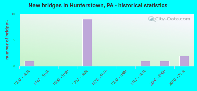
- New bridges - historical statistics
- 11930-1939
- 91960-1969
- 11990-1999
- 12000-2009
- 22010-2019


- Bridge Condition - Deck
- 14.3%Excellent
- 14.3%Very good
- 42.9%Good
- 28.6%Satisfactory

- Bridge Condition - Superstructure
- 57.1%Very good
- 28.6%Good
- 14.3%Satisfactory

- Bridge Condition - Substructure
- 14.3%Very good
- 71.4%Good
- 14.3%Satisfactory

- Bridge Condition - Channel
- 85.7%Satisfactory
- 14.3%Fair
Find on map >> Show street view
Structure Number: 2, Location: NE OF GETTYSBURG (Lat: 39.868450, Lng: -77.194406), Route carried "on" structure: US 15, Year Built: 1963, Status: Open, Structure Length: 0.70m (2.30ft), Average Daily Traffic: 17,930 (year 2021), Truck Traffic: 21%, Average Future Daily Traffic: 24,080 (year 2032), Design Load: HS 20, Features Intersected: BRANCH ROCK CREEK
Minimum Vertical Clearance: 30+ m (98+ ft), Kilometerpoint: 19.948, Lanes on structure: 4, Base Highway Network: Yes, Owner: State Highway Agency, Approaching Roadway Width: 23.2m (76.1ft), Skew: 3 degrees, Material/Design: Concrete, Design/Construction: Culvert, Number Of Spans In Main Unit: 1, Length of Maximum Span: 7.0m (23.0ft)
Condition: Channel: Fair, Culverts: Satisfactory, Operating Rating: 69.9 metric tons, Method Used To Determine Operating Rating: Load Factor (LF), Inventory Rating: 46.3 metric tons, Method Used To Determine Inventory Rating: Load Factor (LF), Structural Evaluation: Equal to present minimum criteria, Waterway Adequacy: Superior to present desirable criteria, Approach Roadway Alignment: Equal to present desirable criteria, Length Of Structure Improvement: 1.30m (4.27ft), Designated Inspection Frequency: Every 24 months, Inspection Date: April 2021
Find on map >> Show street view
Structure Number: 163, Location: 2 3/4 MI.N.W. HUNTERSTOWN (Lat: 39.893992, Lng: -77.194400), Route carried "on" structure: State highway 394, Year Built: 1991, Status: Open, Structure Length: 0.76m (2.49ft), Average Daily Traffic: 4,597 (year 2021), Truck Traffic: 8%, Average Future Daily Traffic: 2,959 (year 2032), Design Load: HS 25 or greater, Features Intersected: ROCK CREEK
Minimum Vertical Clearance: 30+ m (98+ ft), Kilometerpoint: 6.845, Lanes on structure: 2, Owner: State Highway Agency, Approaching Roadway Width: 9.8m (32.2ft), Material/Design: Prestressed concrete, Design/Construction: Box Beam or Girders - Single/Spread, Number Of Spans In Main Unit: 1, Length of Maximum Span: 7.3m (24.0ft), Curb or Sidewalk Widths: Left: 0.2m (0.7ft), Right: 0.2m (0.7ft), Curb-To-Curb Width: 9.8m (32.2ft), Out-to-Out Width: 10.8m (35.4ft)
Condition: Deck: Good, Superstructure: Very good, Substructure: Good, Channel: Satisfactory, Operating Rating: 63.5 metric tons, Method Used To Determine Operating Rating: Load Factor (LF), Inventory Rating: 38.1 metric tons, Method Used To Determine Inventory Rating: Load Factor (LF), Structural Evaluation: Better than present minimum criteria, Deck Geometry: Meets minimum limits, Waterway Adequacy: Superior to present desirable criteria, Approach Roadway Alignment: Equal to present desirable criteria, Length Of Structure Improvement: 1.40m (4.59ft), Designated Inspection Frequency: Every 24 months, Inspection Date: May 2021, Bridge Improvement Cost: $25,000, Roadway Improvement Cost: $75,000, Total Project Cost: $342,000, Deck Structure Type: Concrete Cast-file-Place, Wearing Surface/Protective System: Wearing Surface: Monolithic Concrete, Deck Protection: Epoxy Coated Reinforcing
Find on map >> Show street view
Structure Number: 2, Location: 2.5 MI N OF HUNTERSTOWN (Lat: 39.914367, Lng: -77.146372), Route carried "on" structure: State highway , Year Built: 1963, Status: Open, Structure Length: 0.88m (2.89ft), Average Daily Traffic: 201 (year 2022), Truck Traffic: 12%, Average Future Daily Traffic: 686 (year 2032), Design Load: HS 20, Features Intersected: TRIB OF CONEWAGO CREEK, Facility Carried by Structure: SR 1017
Minimum Vertical Clearance: 30+ m (98+ ft), Kilometerpoint: 3.421, Lanes on structure: 2, Owner: State Highway Agency, Approaching Roadway Width: 6.7m (22.0ft), Material/Design: Concrete, Design/Construction: Slab, Number Of Spans In Main Unit: 1, Length of Maximum Span: 8.5m (27.9ft), Curb or Sidewalk Widths: Left: 0.5m (1.6ft), Right: 0.5m (1.6ft), Curb-To-Curb Width: 9.1m (29.9ft), Out-to-Out Width: 10.8m (35.4ft)
Condition: Deck: Satisfactory, Superstructure: Satisfactory, Substructure: Good, Channel: Satisfactory, Operating Rating: 59.0 metric tons, Method Used To Determine Operating Rating: Load Factor (LF), Inventory Rating: 35.4 metric tons, Method Used To Determine Inventory Rating: Load Factor (LF), Structural Evaluation: Equal to present minimum criteria, Deck Geometry: Equal to present minimum criteria, Waterway Adequacy: Superior to present desirable criteria, Approach Roadway Alignment: Equal to present desirable criteria, Length Of Structure Improvement: 1.60m (5.25ft), Designated Inspection Frequency: Every 24 months, Inspection Date: June 2021, Wearing Surface/Protective System: Wearing Surface: Bituminous, Membrane: Preformed Fabric
Find on map >> Show street view
Structure Number: 249, Location: N.W. OF NEW OXFORD (Lat: 39.878025, Lng: -77.100753), Route carried "on" structure: State highway , Year Built: 1965, Status: Open, Structure Length: 1.62m (5.31ft), Average Daily Traffic: 623 (year 2020), Truck Traffic: 9%, Average Future Daily Traffic: 896 (year 2032), Design Load: H 20, Features Intersected: SWIFT RUN, Facility Carried by Structure: SR 2015
Minimum Vertical Clearance: 30+ m (98+ ft), Kilometerpoint: 2.570, Lanes on structure: 2, Owner: State Highway Agency, Approaching Roadway Width: 7.3m (24.0ft), Material/Design: Prestressed concrete, Design/Construction: Box Beam or Girders - Single/Spread, Number Of Spans In Main Unit: 1, Length of Maximum Span: 15.8m (51.8ft), Curb or Sidewalk Widths: Left: 0.5m (1.6ft), Right: 0.5m (1.6ft), Curb-To-Curb Width: 9.1m (29.9ft), Out-to-Out Width: 10.8m (35.4ft)
Condition: Deck: Satisfactory, Superstructure: Good, Substructure: Good, Channel: Satisfactory, Operating Rating: 47.2 metric tons, Method Used To Determine Operating Rating: Load Factor (LF), Inventory Rating: 28.1 metric tons, Method Used To Determine Inventory Rating: Load Factor (LF), Structural Evaluation: Better than present minimum criteria, Deck Geometry: Equal to present minimum criteria, Waterway Adequacy: Better than present minimum criteria, Approach Roadway Alignment: Equal to present desirable criteria, Length Of Structure Improvement: 2.30m (7.55ft), Designated Inspection Frequency: Every 24 months, Inspection Date: April 2021, Deck Structure Type: Concrete Cast-file-Place, Wearing Surface/Protective System: Wearing Surface: Bituminous
Find on map >> Show street view
Structure Number: 286, Location: 2 1/2 MI.N.E. GETTYSBURG (Lat: 39.864050, Lng: -77.189042), Route carried "on" structure: State highway , Year Built: 1934, Year Reconstructed: 2014, Status: Open, Structure Length: 0.94m (3.08ft), Average Daily Traffic: 1,162 (year 2020), Truck Traffic: 3%, Average Future Daily Traffic: 1,565 (year 2032), Design Load: HL 93, Features Intersected: ROCK CREEK, Facility Carried by Structure: SR 3003
Minimum Vertical Clearance: 30+ m (98+ ft), Kilometerpoint: 3.961, Lanes on structure: 2, Owner: State Highway Agency, Approaching Roadway Width: 6.4m (21.0ft), Material/Design: Steel, Design/Construction: Stringer/Multi-beam, Number Of Spans In Main Unit: 1, Length of Maximum Span: 8.2m (26.9ft), Curb or Sidewalk Widths: Left: 0.2m (0.7ft), Right: 0.2m (0.7ft), Curb-To-Curb Width: 6.7m (22.0ft), Out-to-Out Width: 7.3m (24.0ft)
Condition: Deck: Good, Superstructure: Very good, Substructure: Satisfactory, Channel: Satisfactory, Operating Rating: 48.3 metric tons, Method Used To Determine Operating Rating: Assigned ratings based on Load and Resistance Factor Design (LRFD) reported by rating factor (RF) using HL93 loadings, Inventory Rating: 37.3 metric tons, Method Used To Determine Inventory Rating: Assigned ratings based on Load and Resistance Factor Design (LRFD) reported by rating factor (RF) using HL93 loadings, Structural Evaluation: Equal to present minimum criteria, Deck Geometry: High priority of corrective action, Waterway Adequacy: Better than present minimum criteria, Approach Roadway Alignment: Equal to present desirable criteria, Length Of Structure Improvement: 1.60m (5.25ft), Designated Inspection Frequency: Every 24 months, Inspection Date: April 2021, Deck Structure Type: Concrete Cast-file-Place, Wearing Surface/Protective System: Wearing Surface: Monolithic Concrete, Deck Protection: Epoxy Coated Reinforcing
Find on map >> Show street view
Structure Number: 42699, Location: HUNTERSTOWN (Lat: 39.882678, Lng: -77.162236), Route carried "on" structure: State highway 394, Year Built: 2004, Status: Open, Structure Length: 0.85m (2.79ft), Average Daily Traffic: 3,054 (year 2020), Truck Traffic: 9%, Average Future Daily Traffic: 4,436 (year 2032), Design Load: HL 93, Features Intersected: BEAVER DAM CREEK
Minimum Vertical Clearance: 30+ m (98+ ft), Kilometerpoint: 9.598, Lanes on structure: 2, Owner: State Highway Agency, Approaching Roadway Width: 7.3m (24.0ft), Skew: 3 degrees, Material/Design: Prestressed concrete, Design/Construction: Slab, Number Of Spans In Main Unit: 1, Length of Maximum Span: 7.9m (25.9ft), Curb-To-Curb Width: 8.6m (28.2ft), Out-to-Out Width: 9.8m (32.2ft)
Condition: Deck: Very good, Superstructure: Very good, Substructure: Good, Channel: Satisfactory, Operating Rating: 93.4 metric tons, Method Used To Determine Operating Rating: Load and Resistance Factor (LRFR), Inventory Rating: 49.0 metric tons, Method Used To Determine Inventory Rating: Load and Resistance Factor (LRFR), Structural Evaluation: Better than present minimum criteria, Deck Geometry: Meets minimum limits, Waterway Adequacy: Superior to present desirable criteria, Approach Roadway Alignment: Equal to present desirable criteria, Length Of Structure Improvement: 1.50m (4.92ft), Designated Inspection Frequency: Every 24 months, Inspection Date: June 2021, Deck Structure Type: Concrete Cast-file-Place, Wearing Surface/Protective System: Wearing Surface: Monolithic Concrete, Deck Protection: Epoxy Coated Reinforcing
Find on map >> Show street view
Structure Number: 4612, Location: NE of Gettysburg (Lat: 39.872517, Lng: -77.202892), Route carried "on" structure: US 15B, Year Built: 2010, Status: Open, Structure Length: 1.86m (6.10ft), Average Daily Traffic: 3,153 (year 2020), Truck Traffic: 4%, Average Future Daily Traffic: 8,505 (year 2032), Design Load: HL 93, Features Intersected: Trib Rock Cr, Facility Carried by Structure: Old HBG Rd 3001
Minimum Vertical Clearance: 30+ m (98+ ft), Kilometerpoint: 19.357, Lanes on structure: 2, Base Highway Network: Yes, Owner: State Highway Agency, Approaching Roadway Width: 8.5m (27.9ft), Material/Design: Prestressed concrete, Design/Construction: Box Beam or Girders - Multiple, Number Of Spans In Main Unit: 1, Length of Maximum Span: 18.3m (60.0ft), Curb or Sidewalk Widths: Left: 0.2m (0.7ft), Right: 0.2m (0.7ft), Curb-To-Curb Width: 10.4m (34.1ft), Out-to-Out Width: 11.4m (37.4ft)
Condition: Deck: Good, Superstructure: Good, Substructure: Good, Channel: Satisfactory, Operating Rating: 73.5 metric tons, Method Used To Determine Operating Rating: Load and Resistance Factor (LRFR), Inventory Rating: 49.0 metric tons, Method Used To Determine Inventory Rating: Load and Resistance Factor (LRFR), Structural Evaluation: Better than present minimum criteria, Deck Geometry: Somewhat better than minimum adequacy, Waterway Adequacy: Equal to present desirable criteria, Approach Roadway Alignment: Equal to present desirable criteria, Designated Inspection Frequency: Every 24 months, Inspection Date: November 2020, Deck Structure Type: Concrete Cast-file-Place, Wearing Surface/Protective System: Wearing Surface: Monolithic Concrete, Deck Protection: Epoxy Coated Reinforcing
Find on map >> Show street view
Structure Number: 53909, Location: 2 MI SE OF HUNTERSTOWN (Lat: 39.861111, Lng: -77.135889), Route carried "on" structure: State highway , Year Built: 2019, Status: Open, Structure Length: 2.29m (7.51ft), Average Daily Traffic: 1,656 (year 2022), Truck Traffic: 6%, Average Future Daily Traffic: 1,515 (year 2032), Design Load: HL 93, Features Intersected: CSX RAILROAD, Facility Carried by Structure: COLEMAN RD
Minimum Vertical Clearance: 30+ m (98+ ft), Kilometerpoint: 2.382, Lanes on structure: 2, Owner: State Highway Agency, Maintenance Responsibility: Private, Approaching Roadway Width: 7.6m (24.9ft), Skew: 1 degrees, Material/Design: Prestressed concrete, Design/Construction: Box Beam or Girders - Single/Spread, Number Of Spans In Main Unit: 1, Length of Maximum Span: 22.6m (74.1ft), Curb-To-Curb Width: 8.5m (27.9ft), Out-to-Out Width: 9.1m (29.9ft)
Condition: Deck: Excellent, Superstructure: Very good, Substructure: Very good, Operating Rating: 48.0 metric tons, Method Used To Determine Operating Rating: Assigned ratings based on Load and Resistance Factor Design (LRFD) reported by rating factor (RF) using HL93 loadings, Inventory Rating: 36.9 metric tons, Method Used To Determine Inventory Rating: Assigned ratings based on Load and Resistance Factor Design (LRFD) reported by rating factor (RF) using HL93 loadings, Structural Evaluation: Equal to present desirable criteria, Deck Geometry: Somewhat better than minimum adequacy, Underclear: High priority of corrective action, Approach Roadway Alignment: Equal to present desirable criteria, Designated Inspection Frequency: Every 24 months, Inspection Date: November 2020, Deck Structure Type: Concrete Cast-file-Place, Wearing Surface/Protective System: Wearing Surface: Integral Concrete, Deck Protection: Epoxy Coated Reinforcing
Find on map >> Show street view
Structure Number: 22, Location: NE OF GETTYSBURG (Lat: 39.911403, Lng: -77.165536), Route carried "under" structure: US 15, Year Built: 1967, Structure Length: 0. m, Average Daily Traffic: 9,197 (year 2021), Truck Traffic: 20%, Features Intersected: US 15; SR 0015, Facility Carried by Structure: T-530; WOODSIDE RD
Minimum Vertical Clearance: 4.57m (14.99ft), Kilometerpoint: 26.454, Lanes on structure: 2, Lanes under structure: 4, Material/Design: Prestressed concrete, Design/Construction: Stringer/Multi-beam, Length of Maximum Span: 21.3m (69.9ft)
Find on map >> Show street view
Structure Number: 22, Location: NE OF GETTYSBURG (Lat: 39.911403, Lng: -77.165536), Route carried "under" structure: US 15, Year Built: 1967, Structure Length: 0. m, Average Daily Traffic: 8,733 (year 2021), Truck Traffic: 21%, Features Intersected: US 15; SR 0015, Facility Carried by Structure: T-530; WOODSIDE RD
Minimum Vertical Clearance: 4.44m (14.57ft), Kilometerpoint: 26.496, Lanes on structure: 2, Lanes under structure: 4, Material/Design: Prestressed concrete, Design/Construction: Stringer/Multi-beam, Length of Maximum Span: 21.3m (69.9ft)
Find on map >> Show street view
Structure Number: 164, Location: W. OF HUNTERSTOWN (Lat: 39.889514, Lng: -77.181711), Route carried "under" structure: US 15, Year Built: 1963, Structure Length: 0. m, Average Daily Traffic: 8,733 (year 2021), Truck Traffic: 21%, Features Intersected: US 15; SR 0015, Facility Carried by Structure: PA 394; SR 0394
Minimum Vertical Clearance: 4.60m (15.09ft), Kilometerpoint: 22.969, Lanes on structure: 2, Lanes under structure: 4, Material/Design: Prestressed concrete, Design/Construction: Stringer/Multi-beam, Length of Maximum Span: 19.8m (65.0ft)
Find on map >> Show street view
Structure Number: 164, Location: W. OF HUNTERSTOWN (Lat: 39.889514, Lng: -77.181711), Route carried "under" structure: US 15, Year Built: 1963, Structure Length: 0. m, Average Daily Traffic: 9,197 (year 2021), Truck Traffic: 20%, Features Intersected: US 15; SR 0015, Facility Carried by Structure: PA 394; SR 0394
Minimum Vertical Clearance: 4.52m (14.83ft), Kilometerpoint: 22.940, Lanes on structure: 2, Lanes under structure: 4, Material/Design: Prestressed concrete, Design/Construction: Stringer/Multi-beam, Length of Maximum Span: 19.8m (65.0ft)
Find on map >> Show street view
Structure Number: 285, Location: 2 1/2 MI. N.E. GETTYSBURG (Lat: 39.858767, Lng: -77.198039), Route carried "under" structure: US 15, Year Built: 1963, Structure Length: 0. m, Average Daily Traffic: 8,733 (year 2021), Truck Traffic: 21%, Features Intersected: US 15; SR 0015, Facility Carried by Structure: SR 3003
Minimum Vertical Clearance: 4.62m (15.16ft), Kilometerpoint: 19.951, Lanes on structure: 2, Lanes under structure: 4, Material/Design: Prestressed concrete, Design/Construction: Stringer/Multi-beam, Length of Maximum Span: 19.5m (64.0ft)
Find on map >> Show street view
Structure Number: 285, Location: 2 1/2 MI. N.E. GETTYSBURG (Lat: 39.858767, Lng: -77.198039), Route carried "under" structure: US 15, Year Built: 1963, Structure Length: 0. m, Average Daily Traffic: 9,197 (year 2021), Truck Traffic: 20%, Features Intersected: US 15; SR 0015, Facility Carried by Structure: SR 3003
Minimum Vertical Clearance: 4.62m (15.16ft), Kilometerpoint: 19.948, Lanes on structure: 2, Lanes under structure: 4, Material/Design: Prestressed concrete, Design/Construction: Stringer/Multi-beam, Length of Maximum Span: 19.5m (64.0ft)