Bridge Statistics for Hummelstown, Pennsylvania (PA)
Condition, Traffic, Stress, Structural Evaluation, Project Costs
- National Bridge Inventory (NBI) Statistics
- 16Number of bridges
- 233ft / 70.7mTotal length
- $9,616,000Total costs
- 164,941Total average daily traffic
- 7,428Total average daily truck traffic
- National Bridge Inventory (NBI) Registered Bridges for Hummelstown
- No street view available for this location
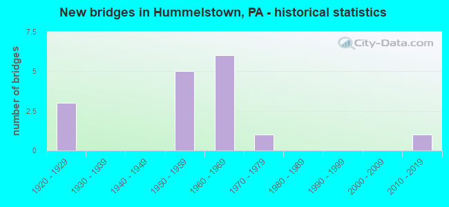
- New bridges - historical statistics
- 31920-1929
- 51950-1959
- 61960-1969
- 11970-1979
- 12010-2019

- Reconstructed bridges - Historical Statistics
- 31970-1979
- 21980-1989
- 01990-1999
- 12000-2009


- Bridge Condition - Deck
- 12.5%Very good
- 50.0%Good
- 25.0%Satisfactory
- 12.5%Fair

- Bridge Condition - Superstructure
- 20.0%Very good
- 20.0%Good
- 20.0%Satisfactory
- 40.0%Fair

- Bridge Condition - Substructure
- 10.0%Very good
- 30.0%Good
- 20.0%Satisfactory
- 40.0%Fair

- Bridge Condition - Channel
- 42.9%Good
- 14.3%Satisfactory
- 42.9%Fair
Find on map >> Show street view
Structure Number: 14371, Location: Hummelstown (Lat: 40.260931, Lng: -76.726500), Route carried "on" structure: US 322, Year Built: 1953, Year Reconstructed: 1993, Status: Open, Structure Length: 17.83m (58.50ft), Average Daily Traffic: 42,085 (year 2021), Truck Traffic: 5%, Average Future Daily Traffic: 55,987 (year 2032), Design Load: HS 25 or greater, Features Intersected: Swatara Creek
Minimum Vertical Clearance: 30+ m (98+ ft), Kilometerpoint: 7.825, Lanes on structure: 4, Base Highway Network: Yes, Owner: State Highway Agency, Approaching Roadway Width: 19.5m (64.0ft), Skew: 32 degrees, Material/Design: Steel continuous, Design/Construction: Stringer/Multi-beam, Number Of Spans In Main Unit: 6, Length of Maximum Span: 31.7m (104.0ft), Curb or Sidewalk Widths: Left: 0.2m (0.7ft), Right: 0.2m (0.7ft), Curb-To-Curb Width: 18.0m (59.1ft), Out-to-Out Width: 20.0m (65.6ft)
Condition: Deck: Good, Superstructure: Good, Substructure: Good, Channel: Good, Operating Rating: 94.3 metric tons, Method Used To Determine Operating Rating: Load Factor (LF), Inventory Rating: 56.2 metric tons, Method Used To Determine Inventory Rating: Load Factor (LF), Structural Evaluation: Better than present minimum criteria, Deck Geometry: Meets minimum limits, Waterway Adequacy: Equal to present desirable criteria, Approach Roadway Alignment: Equal to present desirable criteria, Length Of Structure Improvement: 18.50m (60.70ft), Designated Inspection Frequency: Every 24 months, Inspection Date: October 2020, Deck Structure Type: Concrete Cast-file-Place, Wearing Surface/Protective System: Wearing Surface: Monolithic Concrete, Deck Protection: Epoxy Coated Reinforcing
Find on map >> Show street view
Structure Number: 14372, Location: 1 MI W OF HUMMELSTOWN (Lat: 40.260953, Lng: -76.724981), Route carried "on" structure: State highway , Year Built: 1953, Year Reconstructed: 2009, Status: Open, Structure Length: 2.74m (8.99ft), Average Daily Traffic: 3,185 (year 2022), Truck Traffic: 1%, Average Future Daily Traffic: 3,907 (year 2032), Design Load: HS 20, Features Intersected: US 322; SR 0322, Facility Carried by Structure: T-390/FDDLRS ELBOW
Minimum Vertical Clearance: 30+ m (98+ ft), Kilometerpoint: 0.000, Lanes on structure: 2, Lanes under structure: 8, Owner: State Highway Agency, Approaching Roadway Width: 7.9m (25.9ft), Skew: 3 degrees, Material/Design: Steel, Design/Construction: Stringer/Multi-beam, Number Of Spans In Main Unit: 1, Length of Maximum Span: 25.9m (85.0ft), Curb or Sidewalk Widths: Left: 0.3m (1.0ft), Right: 0.3m (1.0ft), Curb-To-Curb Width: 7.7m (25.3ft), Out-to-Out Width: 8.7m (28.5ft)
Condition: Deck: Very good, Superstructure: Very good, Substructure: Good, Operating Rating: 98.9 metric tons, Method Used To Determine Operating Rating: Load Factor (LF), Inventory Rating: 59.0 metric tons, Method Used To Determine Inventory Rating: Load Factor (LF), Structural Evaluation: Better than present minimum criteria, Deck Geometry: High priority of replacement, Underclear: High priority of corrective action, Approach Roadway Alignment: Equal to present desirable criteria, Length Of Structure Improvement: 3.50m (11.48ft), Designated Inspection Frequency: Every 24 months, Inspection Date: October 2020, Bridge Improvement Cost: $32,000, Roadway Improvement Cost: $95,000, Total Project Cost: $437,000, Deck Structure Type: Concrete Cast-file-Place, Wearing Surface/Protective System: Wearing Surface: Monolithic Concrete, Deck Protection: Epoxy Coated Reinforcing
Find on map >> Show street view
Structure Number: 14457, Location: .5 MI.S. OF HUMMELSTOWN (Lat: 40.258094, Lng: -76.709114), Route carried "on" structure: State highway , Year Built: 1968, Status: Open, Structure Length: 4.82m (15.81ft), Average Daily Traffic: 8,578 (year 2021), Truck Traffic: 5%, Average Future Daily Traffic: 11,493 (year 2032), Design Load: HS 20, Features Intersected: SR 0322; US 322, Facility Carried by Structure: SR 2003
Minimum Vertical Clearance: 30+ m (98+ ft), Kilometerpoint: 6.407, Lanes on structure: 2, Lanes under structure: 8, Owner: State Highway Agency, Approaching Roadway Width: 9.1m (29.9ft), Material/Design: Prestressed concrete, Design/Construction: Stringer/Multi-beam, Number Of Spans In Main Unit: 3, Length of Maximum Span: 26.2m (86.0ft), Curb or Sidewalk Widths: Left: 0.2m (0.7ft), Right: 1.5m (4.9ft), Curb-To-Curb Width: 14.7m (48.2ft), Out-to-Out Width: 17.2m (56.4ft)
Condition: Deck: Good, Superstructure: Satisfactory, Substructure: Good, Operating Rating: 66.2 metric tons, Method Used To Determine Operating Rating: Load Factor (LF), Inventory Rating: 25.4 metric tons, Method Used To Determine Inventory Rating: Load Factor (LF), Structural Evaluation: Equal to present minimum criteria, Deck Geometry: Superior to present desirable criteria, Underclear: High priority of corrective action, Approach Roadway Alignment: Equal to present desirable criteria, Length Of Structure Improvement: 5.70m (18.70ft), Designated Inspection Frequency: Every 24 months, Inspection Date: September 2020, Bridge Improvement Cost: $113,000, Roadway Improvement Cost: $333,000, Total Project Cost: $1,527,000, Deck Structure Type: Concrete Cast-file-Place, Wearing Surface/Protective System: Wearing Surface: Latex Concrete
Find on map >> Show street view
Structure Number: 14459, Location: S. HANOVER TOWNSHIP (Lat: 40.268386, Lng: -76.709153), Route carried "on" structure: State highway , Year Built: 1921, Year Reconstructed: 1978, Status: Open, Structure Length: 7.50m (24.61ft), Average Daily Traffic: 3,379 (year 2022), Truck Traffic: 3%, Average Future Daily Traffic: 3,642 (year 2032), Features Intersected: SWATARA CREEK, Facility Carried by Structure: SR 2003
Minimum Vertical Clearance: 30+ m (98+ ft), Kilometerpoint: 7.796, Lanes on structure: 2, Owner: State Highway Agency, Approaching Roadway Width: 9.1m (29.9ft), Material/Design: Concrete, Design/Construction: Arch - Deck, Number Of Spans In Main Unit: 3, Length of Maximum Span: 28.0m (91.9ft), Curb or Sidewalk Widths: Left: 0.2m (0.7ft), Right: 1.2m (3.9ft), Curb-To-Curb Width: 7.3m (24.0ft), Out-to-Out Width: 8.2m (26.9ft)
Condition: Superstructure: Fair, Substructure: Fair, Channel: Fair, Operating Rating: 56.2 metric tons, Method Used To Determine Operating Rating: Field evaluation and documented engineering judgment, Inventory Rating: 33.6 metric tons, Method Used To Determine Inventory Rating: Field evaluation and documented engineering judgment, Structural Evaluation: Somewhat better than minimum adequacy, Deck Geometry: High priority of replacement, Waterway Adequacy: Equal to present minimum criteria, Approach Roadway Alignment: Equal to present desirable criteria, Length Of Structure Improvement: 13.50m (44.29ft), Designated Inspection Frequency: Every 24 months, Underwater Inspection Frequency: Every 24 months, Inspection Date: September 2020, Underwater Inspection Date: July 2020, Bridge Improvement Cost: $304,000, Roadway Improvement Cost: $896,000, Total Project Cost: $4,105,000
Find on map >> Show street view
Structure Number: 14467, Location: .5 MI. S. HUMMELSTOWN (Lat: 40.258839, Lng: -76.699811), Route carried "on" structure: State highway , Year Built: 1968, Status: Open, Structure Length: 4.66m (15.29ft), Average Daily Traffic: 4,194 (year 2022), Truck Traffic: 2%, Average Future Daily Traffic: 5,978 (year 2032), Design Load: HS 20, Features Intersected: SR 0322; US 322, Facility Carried by Structure: SR 2005 WALTONVILL
Minimum Vertical Clearance: 30+ m (98+ ft), Kilometerpoint: 7.617, Lanes on structure: 2, Lanes under structure: 8, Owner: State Highway Agency, Approaching Roadway Width: 16.2m (53.1ft), Material/Design: Prestressed concrete, Design/Construction: Stringer/Multi-beam, Number Of Spans In Main Unit: 3, Length of Maximum Span: 26.2m (86.0ft), Curb or Sidewalk Widths: Left: 1.5m (4.9ft), Right: 0.2m (0.7ft), Curb-To-Curb Width: 13.7m (44.9ft), Out-to-Out Width: 16.2m (53.1ft)
Condition: Deck: Good, Superstructure: Satisfactory, Substructure: Fair, Operating Rating: 77.1 metric tons, Method Used To Determine Operating Rating: Load Factor (LF), Inventory Rating: 18.1 metric tons, Method Used To Determine Inventory Rating: Load Factor (LF), Structural Evaluation: Somewhat better than minimum adequacy, Deck Geometry: Superior to present desirable criteria, Underclear: High priority of corrective action, Approach Roadway Alignment: Equal to present desirable criteria, Length Of Structure Improvement: 5.50m (18.04ft), Designated Inspection Frequency: Every 24 months, Inspection Date: August 2020, Bridge Improvement Cost: $47,000, Roadway Improvement Cost: $138,000, Total Project Cost: $633,000, Deck Structure Type: Concrete Cast-file-Place, Wearing Surface/Protective System: Wearing Surface: Latex Concrete
Find on map >> Show street view
Structure Number: 14474, Location: 1 MI. N. HUMMELSTOWN (Lat: 40.289606, Lng: -76.710608), Route carried "on" structure: State highway , Year Built: 1923, Year Reconstructed: 1977, Status: Open, Structure Length: 0.82m (2.69ft), Average Daily Traffic: 1,534 (year 2021), Truck Traffic: 2%, Average Future Daily Traffic: 1,921 (year 2032), Design Load: H 15, Features Intersected: KELLOCK RUN, Facility Carried by Structure: SR 2010
Minimum Vertical Clearance: 30+ m (98+ ft), Kilometerpoint: 4.950, Lanes on structure: 2, Owner: State Highway Agency, Approaching Roadway Width: 8.5m (27.9ft), Skew: 4 degrees, Material/Design: Concrete, Design/Construction: Slab, Number Of Spans In Main Unit: 1, Length of Maximum Span: 7.3m (24.0ft), Curb or Sidewalk Widths: Left: 0.2m (0.7ft), Right: 0.2m (0.7ft), Curb-To-Curb Width: 11.6m (38.1ft), Out-to-Out Width: 12.6m (41.3ft)
Condition: Deck: Satisfactory, Superstructure: Fair, Substructure: Satisfactory, Channel: Satisfactory, Operating Rating: 66.2 metric tons, Method Used To Determine Operating Rating: Load Factor (LF), Inventory Rating: 39.9 metric tons, Method Used To Determine Inventory Rating: Load Factor (LF), Structural Evaluation: Somewhat better than minimum adequacy, Deck Geometry: Equal to present minimum criteria, Waterway Adequacy: Better than present minimum criteria, Approach Roadway Alignment: Somewhat better than minimum adequacy, Length Of Structure Improvement: 1.40m (4.59ft), Designated Inspection Frequency: Every 24 months, Inspection Date: September 2020, Deck Structure Type: Concrete Cast-file-Place, Wearing Surface/Protective System: Wearing Surface: Bituminous, Membrane: Preformed Fabric
Find on map >> Show street view
Structure Number: 1449, Location: HUMMELSTOWN BORO (Lat: 40.262700, Lng: -76.726150), Route carried "on" structure: State highway , Year Built: 1922, Status: Open, Structure Length: 11.49m (37.70ft), Average Daily Traffic: 6,863 (year 2022), Truck Traffic: 3%, Average Future Daily Traffic: 8,700 (year 2032), Design Load: H 15, Features Intersected: SWATARA CREEK, Facility Carried by Structure: SR 2018
Minimum Vertical Clearance: 30+ m (98+ ft), Kilometerpoint: 0.000, Lanes on structure: 2, Owner: State Highway Agency, Approaching Roadway Width: 11.6m (38.1ft), Skew: 1 degrees, Material/Design: Concrete, Design/Construction: Arch - Deck, Number Of Spans In Main Unit: 4, Length of Maximum Span: 27.4m (89.9ft), Curb or Sidewalk Widths: Left: 1.5m (4.9ft), Right: 0.0m, Curb-To-Curb Width: 7.3m (24.0ft), Out-to-Out Width: 9.8m (32.2ft)
Condition: Superstructure: Fair, Substructure: Fair, Channel: Good, Operating Rating: 49.0 metric tons, Method Used To Determine Operating Rating: Load Factor (LF), Inventory Rating: 32.7 metric tons, Method Used To Determine Inventory Rating: Load Factor (LF), Structural Evaluation: Somewhat better than minimum adequacy, Deck Geometry: High priority of replacement, Waterway Adequacy: Equal to present desirable criteria, Approach Roadway Alignment: Equal to present desirable criteria, Length Of Structure Improvement: 12.40m (40.68ft), Designated Inspection Frequency: Every 24 months, Inspection Date: December 2020, Bridge Improvement Cost: $169,000, Roadway Improvement Cost: $498,000, Total Project Cost: $2,282,000
Find on map >> Show street view
Structure Number: 14646, Location: 1 SW HUMMELSTWN/DERRY (Lat: 40.249864, Lng: -76.736092), Route carried "on" structure: City street , Year Built: 1973, Year Reconstructed: 1989, Status: Open, Structure Length: 9.36m (30.71ft), Average Daily Traffic: 350 (year 2021), Truck Traffic: 6%, Average Future Daily Traffic: 490 (year 2041), Design Load: HS 20, Features Intersected: SWATARA CREEK, Facility Carried by Structure: FIDDLERS ELBOW RD
Minimum Vertical Clearance: 30+ m (98+ ft), Kilometerpoint: 0.000, Lanes on structure: 2, Owner: County Highway Agency, Approaching Roadway Width: 8.5m (27.9ft), Material/Design: Prestressed concrete, Design/Construction: Box Beam or Girders - Multiple, Number Of Spans In Main Unit: 4, Length of Maximum Span: 22.9m (75.1ft), Curb or Sidewalk Widths: Left: 0.2m (0.7ft), Right: 0.2m (0.7ft), Curb-To-Curb Width: 8.6m (28.2ft), Out-to-Out Width: 9.6m (31.5ft)
Condition: Deck: Fair, Superstructure: Fair, Substructure: Satisfactory, Channel: Fair, Operating Rating: 72.6 metric tons, Method Used To Determine Operating Rating: Load Factor (LF), Inventory Rating: 26.3 metric tons, Method Used To Determine Inventory Rating: Load Factor (LF), Structural Evaluation: Somewhat better than minimum adequacy, Deck Geometry: Equal to present minimum criteria, Waterway Adequacy: Equal to present desirable criteria, Approach Roadway Alignment: Equal to present desirable criteria, Length Of Structure Improvement: 10.30m (33.79ft), Designated Inspection Frequency: Every 24 months, Inspection Date: June 2021, Bridge Improvement Cost: $47,000, Roadway Improvement Cost: $138,000, Total Project Cost: $632,000, Deck Structure Type: Other, Wearing Surface/Protective System: Wearing Surface: Bituminous
Find on map >> Show street view
Structure Number: 14698, Location: .5W HUMLTN/S.HAN/SWTR/BVR (Lat: 40.265464, Lng: -76.738356), Route carried "on" structure: City street , Year Built: 1954, Year Reconstructed: 1983, Status: Open, Structure Length: 2.16m (7.09ft), Average Daily Traffic: 550 (year 2021), Truck Traffic: 1%, Average Future Daily Traffic: 630 (year 2041), Design Load: HS 20, Features Intersected: BEAVER CREEK, Facility Carried by Structure: PLEASANTVIEW RD
Minimum Vertical Clearance: 30+ m (98+ ft), Kilometerpoint: 0.000, Lanes on structure: 2, Owner: County Highway Agency, Approaching Roadway Width: 8.5m (27.9ft), Material/Design: Prestressed concrete, Design/Construction: Box Beam or Girders - Single/Spread, Number Of Spans In Main Unit: 2, Length of Maximum Span: 10.1m (33.1ft), Curb or Sidewalk Widths: Left: 0.2m (0.7ft), Right: 0.2m (0.7ft), Curb-To-Curb Width: 8.5m (27.9ft), Out-to-Out Width: 9.6m (31.5ft)
Condition: Deck: Satisfactory, Superstructure: Good, Substructure: Fair, Channel: Fair, Operating Rating: 87.1 metric tons, Method Used To Determine Operating Rating: Load Factor (LF), Inventory Rating: 40.8 metric tons, Method Used To Determine Inventory Rating: Load Factor (LF), Structural Evaluation: Somewhat better than minimum adequacy, Deck Geometry: Somewhat better than minimum adequacy, Waterway Adequacy: Better than present minimum criteria, Approach Roadway Alignment: Better than present minimum criteria, Length Of Structure Improvement: 2.20m (7.22ft), Designated Inspection Frequency: Every 24 months, Inspection Date: June 2021, Deck Structure Type: Concrete Cast-file-Place, Wearing Surface/Protective System: Wearing Surface: Monolithic Concrete, Deck Protection: Epoxy Coated Reinforcing
Find on map >> Show street view
Structure Number: 54365, Location: Swatra/Han Twp/Humlstown (Lat: 40.270517, Lng: -76.716369), Route carried "on" structure: City street , Year Built: 2017, Status: Open, Structure Length: 9.27m (30.41ft), Average Daily Traffic: 1,546 (year 2021), Average Future Daily Traffic: 1,700 (year 2041), Design Load: HL 93, Features Intersected: Swatara Creek, Facility Carried by Structure: T-690 Duke Street
Minimum Vertical Clearance: 30+ m (98+ ft), Kilometerpoint: 0.000, Lanes on structure: 2, Toll: Toll bridge, Owner: County Highway Agency, Approaching Roadway Width: 7.9m (25.9ft), Material/Design: Prestressed concrete continuous, Design/Construction: Box Beam or Girders - Single/Spread, Number Of Spans In Main Unit: 3, Length of Maximum Span: 30.5m (100.1ft), Curb or Sidewalk Widths: Left: 1.7m (5.6ft), Right: 0.0m, Curb-To-Curb Width: 7.9m (25.9ft), Out-to-Out Width: 10.6m (34.8ft)
Condition: Deck: Good, Superstructure: Very good, Substructure: Very good, Channel: Good, Operating Rating: 72.9 metric tons, Method Used To Determine Operating Rating: Assigned ratings based on Load and Resistance Factor Design (LRFD) reported by rating factor (RF) using HL93 loadings, Inventory Rating: 55.7 metric tons, Method Used To Determine Inventory Rating: Assigned ratings based on Load and Resistance Factor Design (LRFD) reported by rating factor (RF) using HL93 loadings, Structural Evaluation: Equal to present desirable criteria, Deck Geometry: Meets minimum limits, Waterway Adequacy: Equal to present minimum criteria, Approach Roadway Alignment: Somewhat better than minimum adequacy, Designated Inspection Frequency: Every 24 months, Inspection Date: May 2021, Deck Structure Type: Concrete Cast-file-Place, Wearing Surface/Protective System: Wearing Surface: Monolithic Concrete, Deck Protection: Epoxy Coated Reinforcing
Find on map >> Show street view
Structure Number: 14372, Location: 1 MI W OF HUMMELSTOWN (Lat: 40.260953, Lng: -76.724981), Route carried "under" structure: US 322, Year Built: 1953, Structure Length: 0. m, Average Daily Traffic: 21,183 (year 2021), Truck Traffic: 4%, Features Intersected: US 322; SR 0322, Facility Carried by Structure: T-390/FDDLRS ELBOW
Minimum Vertical Clearance: 4.65m (15.26ft), Kilometerpoint: 7.726, Lanes on structure: 2, Lanes under structure: 4, Material/Design: Steel, Design/Construction: Stringer/Multi-beam, Length of Maximum Span: 25.9m (85.0ft)
Find on map >> Show street view
Structure Number: 14372, Location: 1 MI W OF HUMMELSTOWN (Lat: 40.260953, Lng: -76.724981), Route carried "under" structure: US 322, Year Built: 1953, Structure Length: 0. m, Average Daily Traffic: 20,902 (year 2021), Truck Traffic: 5%, Features Intersected: US 322; SR 0322, Facility Carried by Structure: T-390/FDDLRS ELBOW
Minimum Vertical Clearance: 4.98m (16.34ft), Kilometerpoint: 7.825, Lanes on structure: 2, Lanes under structure: 4, Material/Design: Steel, Design/Construction: Stringer/Multi-beam, Length of Maximum Span: 25.9m (85.0ft)
Find on map >> Show street view
Structure Number: 14457, Location: .5 MI.S. OF HUMMELSTOWN (Lat: 40.258094, Lng: -76.709114), Route carried "under" structure: US 322, Year Built: 1968, Structure Length: 0. m, Average Daily Traffic: 13,061 (year 2020), Truck Traffic: 5%, Features Intersected: SR 0322; US 322, Facility Carried by Structure: SR 2003
Minimum Vertical Clearance: 4.88m (16.01ft), Kilometerpoint: 9.323, Lanes on structure: 2, Lanes under structure: 4, Material/Design: Prestressed concrete, Design/Construction: Stringer/Multi-beam, Length of Maximum Span: 26.2m (86.0ft)
Find on map >> Show street view
Structure Number: 14457, Location: .5 MI.S. OF HUMMELSTOWN (Lat: 40.258094, Lng: -76.709114), Route carried "under" structure: US 322, Year Built: 1968, Structure Length: 0. m, Average Daily Traffic: 12,235 (year 2020), Truck Traffic: 5%, Features Intersected: SR 0322; US 322, Facility Carried by Structure: SR 2003
Minimum Vertical Clearance: 4.50m (14.76ft), Kilometerpoint: 9.429, Lanes on structure: 2, Lanes under structure: 4, Material/Design: Prestressed concrete, Design/Construction: Stringer/Multi-beam, Length of Maximum Span: 26.2m (86.0ft)
Find on map >> Show street view
Structure Number: 14467, Location: .5 MI. S. HUMMELSTOWN (Lat: 40.258839, Lng: -76.699811), Route carried "under" structure: US 322, Year Built: 1968, Structure Length: 0. m, Average Daily Traffic: 12,235 (year 2020), Truck Traffic: 5%, Features Intersected: SR 0322; US 322, Facility Carried by Structure: SR 2005 WALTONVILL
Minimum Vertical Clearance: 4.42m (14.50ft), Kilometerpoint: 10.234, Lanes on structure: 2, Lanes under structure: 4, Material/Design: Prestressed concrete, Design/Construction: Stringer/Multi-beam, Length of Maximum Span: 26.2m (86.0ft)
Find on map >> Show street view
Structure Number: 14467, Location: .5 MI. S. HUMMELSTOWN (Lat: 40.258839, Lng: -76.699811), Route carried "under" structure: US 322, Year Built: 1968, Structure Length: 0. m, Average Daily Traffic: 13,061 (year 2020), Truck Traffic: 5%, Features Intersected: SR 0322; US 322, Facility Carried by Structure: SR 2005 WALTONVILL
Minimum Vertical Clearance: 4.44m (14.57ft), Kilometerpoint: 10.118, Lanes on structure: 2, Lanes under structure: 4, Material/Design: Prestressed concrete, Design/Construction: Stringer/Multi-beam, Length of Maximum Span: 26.2m (86.0ft)