Bridge Statistics for Humboldt, Illinois (IL)
Condition, Traffic, Stress, Structural Evaluation, Project Costs
- National Bridge Inventory (NBI) Statistics
- 37Number of bridges
- 299ft / 90.8mTotal length
- $4,939,000Total costs
- 148,460Total average daily traffic
- 52,685Total average daily truck traffic
- National Bridge Inventory (NBI) Registered Bridges for Humboldt
- No street view available for this location
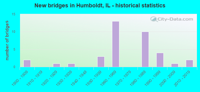
- New bridges - historical statistics
- 21900-1909
- 11920-1929
- 11930-1939
- 31950-1959
- 131960-1969
- 101980-1989
- 41990-1999
- 12000-2009
- 22010-2019

- Reconstructed bridges - Historical Statistics
- 11940-1949
- 01950-1959
- 01960-1969
- 01970-1979
- 01980-1989
- 21990-1999


- Bridge Condition - Deck
- 9.1%Very good
- 39.4%Good
- 33.3%Satisfactory
- 9.1%Fair
- 6.1%Poor
- 3.0%Critical

- Bridge Condition - Superstructure
- 6.1%Very good
- 39.4%Good
- 33.3%Satisfactory
- 12.1%Fair
- 6.1%Poor
- 3.0%Critical

- Bridge Condition - Substructure
- 6.1%Very good
- 51.5%Good
- 12.1%Satisfactory
- 24.2%Fair
- 3.0%Poor
- 3.0%Serious

- Bridge Condition - Channel
- 6.5%Very good
- 25.8%Good
- 29.0%Satisfactory
- 35.5%Fair
- 3.2%Poor
Find on map >> Show street view
Structure Number: 150009, Location: .5 MI S HUMBOLDT (Lat: 39.595925, Lng: -88.304600), Route carried "on" structure: Interstate 57, Year Built: 1967, Status: Open, Structure Length: 2.82m (9.25ft), Average Daily Traffic: 11,700 (year 2021), Truck Traffic: 37%, Average Future Daily Traffic: 9,165 (year 2032), Design Load: HS 20, Features Intersected: S FORK FLAT BRANCH
Minimum Vertical Clearance: 30+ m (98+ ft), Kilometerpoint: 317.788, Lanes on structure: 2, Base Highway Network: Yes, Owner: State Highway Agency, Approaching Roadway Width: 12.2m (40.0ft), Skew: 1 degrees, Material/Design: Concrete continuous, Design/Construction: Slab, Number Of Spans In Main Unit: 3, Length of Maximum Span: 10.4m (34.1ft), Curb or Sidewalk Widths: Left: 0.0m, Right: 0.6m (2.0ft), Curb-To-Curb Width: 11.9m (39.0ft), Out-to-Out Width: 13.3m (43.6ft)
Condition: Deck: Satisfactory, Superstructure: Satisfactory, Substructure: Good, Channel: Good, Operating Rating: 51.2 metric tons, Method Used To Determine Operating Rating: Load Factor (LF) rating reported by rating factor (RF) method using MS18 loading, Inventory Rating: 30.8 metric tons, Method Used To Determine Inventory Rating: Load Factor (LF) rating reported by rating factor (RF) method using MS18 loading, Structural Evaluation: Equal to present minimum criteria, Deck Geometry: Equal to present minimum criteria, Waterway Adequacy: Equal to present desirable criteria, Approach Roadway Alignment: Equal to present desirable criteria, Length Of Structure Improvement: 2.83m (9.28ft), Designated Inspection Frequency: Every 24 months, Other Special Inspection Frequency: Every 12 months, Inspection Date: July 2021, Other Special Inspection Date: September 2021, Bridge Improvement Cost: $485,000, Roadway Improvement Cost: $81,000, Total Project Cost: $566,000, Deck Structure Type: Concrete Cast-file-Place, Wearing Surface/Protective System: Wearing Surface: Bituminous, Membrane: Built-up
Find on map >> Show street view
Structure Number: 15001, Location: .5 MI S HUMBOLDT (Lat: 39.596056, Lng: -88.304508), Route carried "on" structure: Interstate 57, Year Built: 1967, Status: Open, Structure Length: 2.82m (9.25ft), Average Daily Traffic: 11,700 (year 2021), Truck Traffic: 37%, Average Future Daily Traffic: 9,165 (year 2032), Design Load: HS 20, Features Intersected: S FORK FLAT BRANCH
Minimum Vertical Clearance: 30+ m (98+ ft), Kilometerpoint: 317.805, Lanes on structure: 2, Base Highway Network: Yes, Owner: State Highway Agency, Approaching Roadway Width: 12.2m (40.0ft), Skew: 1 degrees, Material/Design: Concrete continuous, Design/Construction: Slab, Number Of Spans In Main Unit: 3, Length of Maximum Span: 10.4m (34.1ft), Curb or Sidewalk Widths: Left: 0.0m, Right: 0.6m (2.0ft), Curb-To-Curb Width: 11.9m (39.0ft), Out-to-Out Width: 13.3m (43.6ft)
Condition: Deck: Satisfactory, Superstructure: Satisfactory, Substructure: Good, Channel: Good, Operating Rating: 51.2 metric tons, Method Used To Determine Operating Rating: Load Factor (LF) rating reported by rating factor (RF) method using MS18 loading, Inventory Rating: 30.8 metric tons, Method Used To Determine Inventory Rating: Load Factor (LF) rating reported by rating factor (RF) method using MS18 loading, Structural Evaluation: Equal to present minimum criteria, Deck Geometry: Equal to present minimum criteria, Waterway Adequacy: Equal to present desirable criteria, Approach Roadway Alignment: Equal to present desirable criteria, Length Of Structure Improvement: 2.83m (9.28ft), Designated Inspection Frequency: Every 24 months, Other Special Inspection Frequency: Every 12 months, Inspection Date: July 2021, Other Special Inspection Date: September 2021, Bridge Improvement Cost: $485,000, Roadway Improvement Cost: $81,000, Total Project Cost: $566,000, Deck Structure Type: Concrete Cast-file-Place, Wearing Surface/Protective System: Wearing Surface: Bituminous, Membrane: Built-up
Find on map >> Show street view
Structure Number: 150011, Location: .5 MI N HUMBOLDT RD (Lat: 39.603153, Lng: -88.299600), Route carried "on" structure: Interstate 57, Year Built: 1967, Year Reconstructed: 2001, Status: Open, Structure Length: 3.54m (11.61ft), Average Daily Traffic: 11,700 (year 2021), Truck Traffic: 37%, Average Future Daily Traffic: 9,165 (year 2032), Design Load: HS 20, Features Intersected: FLAT BRANCH
Minimum Vertical Clearance: 30+ m (98+ ft), Kilometerpoint: 318.690, Lanes on structure: 1, Base Highway Network: Yes, Owner: State Highway Agency, Approaching Roadway Width: 12.2m (40.0ft), Material/Design: Steel continuous, Design/Construction: Stringer/Multi-beam, Number Of Spans In Main Unit: 3, Length of Maximum Span: 12.6m (41.3ft), Curb or Sidewalk Widths: Left: 0.0m, Right: 0.6m (2.0ft), Curb-To-Curb Width: 12.6m (41.3ft), Out-to-Out Width: 13.6m (44.6ft)
Condition: Deck: Satisfactory, Superstructure: Satisfactory, Substructure: Satisfactory, Channel: Good, Operating Rating: 89.1 metric tons, Method Used To Determine Operating Rating: Load Factor (LF) rating reported by rating factor (RF) method using MS18 loading, Inventory Rating: 57.3 metric tons, Method Used To Determine Inventory Rating: Load Factor (LF) rating reported by rating factor (RF) method using MS18 loading, Structural Evaluation: Equal to present minimum criteria, Deck Geometry: Somewhat better than minimum adequacy, Waterway Adequacy: Equal to present desirable criteria, Approach Roadway Alignment: Equal to present desirable criteria, Length Of Structure Improvement: 3.54m (11.61ft), Designated Inspection Frequency: Every 24 months, Inspection Date: January 2021, Bridge Improvement Cost: $621,000, Roadway Improvement Cost: $103,000, Total Project Cost: $724,000, Deck Structure Type: Concrete Cast-file-Place, Wearing Surface/Protective System: Deck Protection: Epoxy Coated Reinforcing
Find on map >> Show street view
Structure Number: 150012, Location: .5 MI N HUMBOLDT (Lat: 39.603278, Lng: -88.299511), Route carried "on" structure: Interstate 57, Year Built: 1967, Year Reconstructed: 2001, Status: Open, Structure Length: 3.54m (11.61ft), Average Daily Traffic: 11,700 (year 2021), Truck Traffic: 37%, Average Future Daily Traffic: 9,165 (year 2032), Design Load: HS 20, Features Intersected: FLAT BRANCH
Minimum Vertical Clearance: 30+ m (98+ ft), Kilometerpoint: 318.706, Lanes on structure: 2, Base Highway Network: Yes, Owner: State Highway Agency, Approaching Roadway Width: 12.2m (40.0ft), Material/Design: Steel continuous, Design/Construction: Stringer/Multi-beam, Number Of Spans In Main Unit: 3, Length of Maximum Span: 12.6m (41.3ft), Curb or Sidewalk Widths: Left: 0.0m, Right: 0.6m (2.0ft), Curb-To-Curb Width: 12.6m (41.3ft), Out-to-Out Width: 13.6m (44.6ft)
Condition: Deck: Satisfactory, Superstructure: Satisfactory, Substructure: Satisfactory, Channel: Good, Operating Rating: 89.1 metric tons, Method Used To Determine Operating Rating: Load Factor (LF) rating reported by rating factor (RF) method using MS18 loading, Inventory Rating: 57.3 metric tons, Method Used To Determine Inventory Rating: Load Factor (LF) rating reported by rating factor (RF) method using MS18 loading, Structural Evaluation: Equal to present minimum criteria, Deck Geometry: Better than present minimum criteria, Waterway Adequacy: Equal to present desirable criteria, Approach Roadway Alignment: Equal to present desirable criteria, Length Of Structure Improvement: 3.54m (11.61ft), Designated Inspection Frequency: Every 24 months, Inspection Date: January 2021, Bridge Improvement Cost: $621,000, Roadway Improvement Cost: $103,000, Total Project Cost: $724,000, Deck Structure Type: Concrete Cast-file-Place, Wearing Surface/Protective System: Deck Protection: Epoxy Coated Reinforcing
Find on map >> Show street view
Structure Number: 150022, Location: W OF HUMBLDT (Lat: 39.599681, Lng: -88.324381), Route carried "on" structure: US 45, Year Built: 1954, Status: Open, Structure Length: 3.66m (12.01ft), Average Daily Traffic: 2,400 (year 2021), Truck Traffic: 10%, Average Future Daily Traffic: 3,430 (year 2032), Design Load: HS 20, Features Intersected: FLAT BRANCH
Minimum Vertical Clearance: 30+ m (98+ ft), Kilometerpoint: 337.518, Lanes on structure: 2, Base Highway Network: Yes, Owner: State Highway Agency, Approaching Roadway Width: 7.3m (24.0ft), Material/Design: Concrete continuous, Design/Construction: Tee Beam, Number Of Spans In Main Unit: 3, Length of Maximum Span: 13.9m (45.6ft), Curb or Sidewalk Widths: Left: 0.6m (2.0ft), Right: 0.6m (2.0ft), Curb-To-Curb Width: 9.1m (29.9ft), Out-to-Out Width: 10.9m (35.8ft)
Condition: Deck: Poor, Superstructure: Fair, Substructure: Fair, Channel: Good, Operating Rating: 50.2 metric tons, Method Used To Determine Operating Rating: Load Factor (LF) rating reported by rating factor (RF) method using MS18 loading, Inventory Rating: 30.1 metric tons, Method Used To Determine Inventory Rating: Load Factor (LF) rating reported by rating factor (RF) method using MS18 loading, Structural Evaluation: Somewhat better than minimum adequacy, Deck Geometry: Meets minimum limits, Waterway Adequacy: Equal to present desirable criteria, Approach Roadway Alignment: Equal to present desirable criteria, Length Of Structure Improvement: 3.66m (12.01ft), Designated Inspection Frequency: Every 24 months, Inspection Date: November 2021, Bridge Improvement Cost: $515,000, Roadway Improvement Cost: $86,000, Total Project Cost: $601,000, Deck Structure Type: Concrete Cast-file-Place, Wearing Surface/Protective System: Wearing Surface: Bituminous, Membrane: Built-up
Find on map >> Show street view
Structure Number: 150033, Location: E OF HUMBOLDT (Lat: 39.601119, Lng: -88.301019), Route carried "on" structure: County highway , Year Built: 1967, Status: Open, Structure Length: 7.72m (25.33ft), Average Daily Traffic: 225 (year 2019), Truck Traffic: 8%, Average Future Daily Traffic: 256 (year 2032), Design Load: HS 15, Features Intersected: I-57, Facility Carried by Structure: CH 16(FAS 1672)
Minimum Vertical Clearance: 30+ m (98+ ft), Kilometerpoint: 1.947, Lanes on structure: 2, Lanes under structure: 4, Owner: State Highway Agency, Approaching Roadway Width: 6.1m (20.0ft), Skew: 2 degrees, Material/Design: Steel continuous, Design/Construction: Stringer/Multi-beam, Number Of Spans In Main Unit: 4, Length of Maximum Span: 23.4m (76.8ft), Curb or Sidewalk Widths: Left: 0.6m (2.0ft), Right: 0.6m (2.0ft), Curb-To-Curb Width: 7.3m (24.0ft), Out-to-Out Width: 9.1m (29.9ft)
Condition: Deck: Satisfactory, Superstructure: Good, Substructure: Good, Operating Rating: 44.4 metric tons, Method Used To Determine Operating Rating: Load Factor (LF) rating reported by rating factor (RF) method using MS18 loading, Inventory Rating: 26.6 metric tons, Method Used To Determine Inventory Rating: Load Factor (LF) rating reported by rating factor (RF) method using MS18 loading, Structural Evaluation: Equal to present minimum criteria, Deck Geometry: Somewhat better than minimum adequacy, Underclear: High priority of corrective action, Approach Roadway Alignment: Equal to present desirable criteria, Designated Inspection Frequency: Every 24 months, Inspection Date: Febuary 2022, Deck Structure Type: Concrete Cast-file-Place
Find on map >> Show street view
Structure Number: 150045, Location: 2.0 MI S OF DOUGLAS (Lat: 39.623000, Lng: -88.293831), Route carried "on" structure: County highway , Year Built: 1967, Status: Open, Structure Length: 6.71m (22.01ft), Average Daily Traffic: 75 (year 2019), Truck Traffic: 1%, Average Future Daily Traffic: 102 (year 2032), Design Load: HS 15, Features Intersected: I-57, Facility Carried by Structure: TR 23
Minimum Vertical Clearance: 30+ m (98+ ft), Kilometerpoint: 5.520, Lanes on structure: 2, Lanes under structure: 4, Owner: State Highway Agency, Approaching Roadway Width: 5.5m (18.0ft), Material/Design: Steel continuous, Design/Construction: Stringer/Multi-beam, Number Of Spans In Main Unit: 4, Length of Maximum Span: 20.5m (67.3ft), Curb-To-Curb Width: 7.3m (24.0ft), Out-to-Out Width: 9.1m (29.9ft)
Condition: Deck: Satisfactory, Superstructure: Good, Substructure: Good, Operating Rating: 48.0 metric tons, Method Used To Determine Operating Rating: Load Factor (LF) rating reported by rating factor (RF) method using MS18 loading, Inventory Rating: 28.8 metric tons, Method Used To Determine Inventory Rating: Load Factor (LF) rating reported by rating factor (RF) method using MS18 loading, Structural Evaluation: Better than present minimum criteria, Deck Geometry: Equal to present minimum criteria, Underclear: High priority of corrective action, Approach Roadway Alignment: Equal to present desirable criteria, Designated Inspection Frequency: Every 24 months, Inspection Date: January 2022, Deck Structure Type: Concrete Cast-file-Place
Find on map >> Show street view
Structure Number: 150046, Location: 1.0 MI S HUMBOLDT (Lat: 39.586561, Lng: -88.311161), Route carried "on" structure: County highway , Year Built: 1967, Status: Open, Structure Length: 7.34m (24.08ft), Average Daily Traffic: 50 (year 2019), Truck Traffic: 4%, Average Future Daily Traffic: 51 (year 2032), Design Load: HS 15, Features Intersected: I-57, Facility Carried by Structure: TR 69
Minimum Vertical Clearance: 30+ m (98+ ft), Kilometerpoint: 0.885, Lanes on structure: 2, Lanes under structure: 4, Owner: State Highway Agency, Approaching Roadway Width: 5.5m (18.0ft), Skew: 2 degrees, Material/Design: Steel continuous, Design/Construction: Stringer/Multi-beam, Number Of Spans In Main Unit: 4, Length of Maximum Span: 22.3m (73.2ft), Curb-To-Curb Width: 7.3m (24.0ft), Out-to-Out Width: 9.1m (29.9ft)
Condition: Deck: Satisfactory, Superstructure: Good, Substructure: Good, Operating Rating: 36.9 metric tons, Method Used To Determine Operating Rating: Allowable Stress (AS) rating reported by rating factor (RF) method using MS18 loading, Inventory Rating: 19.8 metric tons, Method Used To Determine Inventory Rating: Allowable Stress (AS) rating reported by rating factor (RF) method using MS18 loading, Structural Evaluation: Somewhat better than minimum adequacy, Deck Geometry: Equal to present minimum criteria, Underclear: High priority of corrective action, Approach Roadway Alignment: Equal to present desirable criteria, Designated Inspection Frequency: Every 24 months, Inspection Date: Febuary 2022, Deck Structure Type: Concrete Cast-file-Place
Find on map >> Show street view
Structure Number: 150072, Location: 1.5 MI N OF HUMBOLDT (Lat: 39.630864, Lng: -88.317236), Route carried "on" structure: US 45, Year Built: 1997, Status: Open, Structure Length: 0.98m (3.22ft), Average Daily Traffic: 2,400 (year 2021), Truck Traffic: 11%, Average Future Daily Traffic: 3,379 (year 2032), Design Load: HS 20+Mod, Features Intersected: STREAM
Minimum Vertical Clearance: 30+ m (98+ ft), Kilometerpoint: 341.043, Lanes on structure: 2, Base Highway Network: Yes, Owner: State Highway Agency, Approaching Roadway Width: 7.3m (24.0ft), Material/Design: Concrete, Design/Construction: Slab, Number Of Spans In Main Unit: 1, Length of Maximum Span: 8.2m (26.9ft), Curb-To-Curb Width: 10.8m (35.4ft), Out-to-Out Width: 11.8m (38.7ft)
Condition: Deck: Satisfactory, Superstructure: Satisfactory, Substructure: Satisfactory, Channel: Very good, Operating Rating: 75.8 metric tons, Method Used To Determine Operating Rating: Load Factor (LF) rating reported by rating factor (RF) method using MS18 loading, Inventory Rating: 45.4 metric tons, Method Used To Determine Inventory Rating: Load Factor (LF) rating reported by rating factor (RF) method using MS18 loading, Structural Evaluation: Equal to present minimum criteria, Deck Geometry: Somewhat better than minimum adequacy, Waterway Adequacy: Equal to present desirable criteria, Approach Roadway Alignment: Equal to present desirable criteria, Designated Inspection Frequency: Every 24 months, Inspection Date: July 2021, Deck Structure Type: Concrete Cast-file-Place, Wearing Surface/Protective System: Deck Protection: Epoxy Coated Reinforcing
Find on map >> Show street view
Structure Number: 152001, Location: MP 196.4 (Lat: 39.581372, Lng: -88.312558), Route carried "on" structure: Interstate 57, Year Built: 1968, Status: Open, Structure Length: 1.27m (4.17ft), Average Daily Traffic: 23,400 (year 2021), Truck Traffic: 37%, Average Future Daily Traffic: 18,330 (year 2032), Design Load: HS 20+Mod, Features Intersected: STREAM
Minimum Vertical Clearance: 30+ m (98+ ft), Kilometerpoint: 316.034, Lanes on structure: 4, Base Highway Network: Yes, Owner: State Highway Agency, Approaching Roadway Width: 24.4m (80.1ft), Skew: 14 degrees, Material/Design: Concrete, Design/Construction: Culvert, Number Of Spans In Main Unit: 3, Length of Maximum Span: 4.4m (14.4ft)
Condition: Channel: Satisfactory, Culverts: Fair, Operating Rating: 80.0 metric tons, Method Used To Determine Operating Rating: Load Factor (LF) rating reported by rating factor (RF) method using MS18 loading, Inventory Rating: 48.0 metric tons, Method Used To Determine Inventory Rating: Load Factor (LF) rating reported by rating factor (RF) method using MS18 loading, Structural Evaluation: Somewhat better than minimum adequacy, Waterway Adequacy: Better than present minimum criteria, Approach Roadway Alignment: Equal to present desirable criteria, Designated Inspection Frequency: Every 24 months, Inspection Date: November 2021
Find on map >> Show street view
Structure Number: 153006, Location: 1.5 MI E HUMBOLDT (Lat: 39.599208, Lng: -88.289336), Route carried "on" structure: County highway , Year Built: 1958, Status: Open, Structure Length: 1.10m (3.61ft), Average Daily Traffic: 25 (year 2019), Truck Traffic: 4%, Average Future Daily Traffic: 26 (year 2032), Features Intersected: FLAT BRANCH, Facility Carried by Structure: TR 105 A
Minimum Vertical Clearance: 30+ m (98+ ft), Kilometerpoint: 0.225, Lanes on structure: 2, Owner: Town or Township Highway Agency, Approaching Roadway Width: 7.3m (24.0ft), Material/Design: Steel, Design/Construction: Stringer/Multi-beam, Number Of Spans In Main Unit: 1, Length of Maximum Span: 10.7m (35.1ft), Curb-To-Curb Width: 5.8m (19.0ft), Out-to-Out Width: 6.1m (20.0ft)
Condition: Deck: Good, Superstructure: Satisfactory, Substructure: Good, Channel: Fair, Operating Rating: 39.5 metric tons, Method Used To Determine Operating Rating: Load Factor (LF) rating reported by rating factor (RF) method using MS18 loading, Inventory Rating: 23.7 metric tons, Method Used To Determine Inventory Rating: Load Factor (LF) rating reported by rating factor (RF) method using MS18 loading, Structural Evaluation: Equal to present minimum criteria, Deck Geometry: Meets minimum limits, Waterway Adequacy: Equal to present minimum criteria, Approach Roadway Alignment: Better than present minimum criteria, Length Of Structure Improvement: 1.10m (3.61ft), Designated Inspection Frequency: Every 24 months, Inspection Date: January 2021, Bridge Improvement Cost: $87,000, Roadway Improvement Cost: $14,000, Total Project Cost: $101,000, Deck Structure Type: Concrete Cast-file-Place, Wearing Surface/Protective System: Wearing Surface: Bituminous
Find on map >> Show street view
Structure Number: 15303, Location: .5 MI E HUMBOLDT (Lat: 39.608394, Lng: -88.304236), Route carried "on" structure: County highway , Year Built: 1954, Status: Open, Structure Length: 0.83m (2.72ft), Average Daily Traffic: 150 (year 2019), Truck Traffic: 3%, Average Future Daily Traffic: 154 (year 2032), Features Intersected: FLAT BRANCH, Facility Carried by Structure: TR 39 B
Minimum Vertical Clearance: 30+ m (98+ ft), Kilometerpoint: 0.660, Lanes on structure: 2, Owner: Town or Township Highway Agency, Approaching Roadway Width: 7.3m (24.0ft), Material/Design: Steel, Design/Construction: Stringer/Multi-beam, Number Of Spans In Main Unit: 1, Length of Maximum Span: 8.3m (27.2ft), Curb-To-Curb Width: 6.4m (21.0ft), Out-to-Out Width: 6.7m (22.0ft)
Condition: Deck: Fair, Superstructure: Satisfactory, Substructure: Fair, Channel: Fair, Operating Rating: 41.1 metric tons, Method Used To Determine Operating Rating: Load Factor (LF) rating reported by rating factor (RF) method using MS18 loading, Inventory Rating: 24.6 metric tons, Method Used To Determine Inventory Rating: Load Factor (LF) rating reported by rating factor (RF) method using MS18 loading, Structural Evaluation: Somewhat better than minimum adequacy, Deck Geometry: Meets minimum limits, Waterway Adequacy: Equal to present desirable criteria, Approach Roadway Alignment: Equal to present desirable criteria, Length Of Structure Improvement: 0.82m (2.69ft), Designated Inspection Frequency: Every 24 months, Inspection Date: January 2021, Bridge Improvement Cost: $209,000, Roadway Improvement Cost: $24,000, Total Project Cost: $233,000, Deck Structure Type: Concrete Cast-file-Place
Find on map >> Show street view
Structure Number: 153075, Location: .5 MI W HUMBOLDT (Lat: 39.600278, Lng: -88.329633), Route carried "on" structure: County highway , Year Built: 1909, Status: Closed, Structure Length: 1.84m (6.04ft), Average Daily Traffic: 25 (year 2019), Truck Traffic: 8%, Average Future Daily Traffic: 26 (year 2032), Features Intersected: FLAT CREEK, Facility Carried by Structure: TR 53A
Minimum Vertical Clearance: 30+ m (98+ ft), Kilometerpoint: 1.239, Lanes on structure: 1, Owner: Town or Township Highway Agency, Approaching Roadway Width: 4.9m (16.1ft), Material/Design: Steel, Design/Construction: Truss - Thru, Number Of Spans In Main Unit: 1, Length of Maximum Span: 18.1m (59.4ft), Curb-To-Curb Width: 4.1m (13.5ft), Out-to-Out Width: 4.9m (16.1ft)
Condition: Deck: Good, Superstructure: Critical, Substructure: Serious, Channel: Fair, Deck Geometry: Somewhat better than minimum adequacy, Waterway Adequacy: High priority of corrective action, Approach Roadway Alignment: Equal to present minimum criteria, Bridge Posting: Required (Relationship of Operating Rating to Maximum Legal Load: > 39.9% below), Length Of Structure Improvement: 1.83m (6.00ft), Designated Inspection Frequency: Every 24 months, Critical Feature Inspection Frequency: Every 12 months, Inspection Date: January 2022, Critical Feature Inspection Date: January 2022, Bridge Improvement Cost: $338,000, Roadway Improvement Cost: $39,000, Total Project Cost: $377,000, Deck Structure Type: Wood or Timber, Wearing Surface/Protective System: Wearing Surface: Wood or Timber
Find on map >> Show street view
Structure Number: 153084, Location: 1.0 MI S HUMBOLT (Lat: 39.586586, Lng: -88.306256), Route carried "on" structure: County highway , Year Built: 1961, Status: Open, Structure Length: 1.15m (3.77ft), Average Daily Traffic: 50 (year 2019), Truck Traffic: 4%, Average Future Daily Traffic: 51 (year 2032), Features Intersected: FLAT BRANCH, Facility Carried by Structure: TR 69
Minimum Vertical Clearance: 30+ m (98+ ft), Kilometerpoint: 1.336, Lanes on structure: 2, Owner: Town or Township Highway Agency, Approaching Roadway Width: 6.7m (22.0ft), Material/Design: Concrete, Design/Construction: Slab, Number Of Spans In Main Unit: 1, Length of Maximum Span: 11.3m (37.1ft), Curb-To-Curb Width: 8.0m (26.2ft), Out-to-Out Width: 8.0m (26.2ft)
Condition: Deck: Very good, Superstructure: Satisfactory, Substructure: Good, Channel: Satisfactory, Operating Rating: 41.1 metric tons, Method Used To Determine Operating Rating: Load Factor (LF) rating reported by rating factor (RF) method using MS18 loading, Inventory Rating: 24.6 metric tons, Method Used To Determine Inventory Rating: Load Factor (LF) rating reported by rating factor (RF) method using MS18 loading, Structural Evaluation: Equal to present minimum criteria, Deck Geometry: Equal to present minimum criteria, Waterway Adequacy: Equal to present desirable criteria, Approach Roadway Alignment: Equal to present desirable criteria, Designated Inspection Frequency: Every 24 months, Inspection Date: December 2021, Deck Structure Type: Concrete Cast-file-Place
Find on map >> Show street view
Structure Number: 153087, Location: 1.5 MI S HUMBOLT (Lat: 39.579300, Lng: -88.315144), Route carried "on" structure: County highway , Year Built: 1935, Status: Posted for load, Structure Length: 0.85m (2.79ft), Average Daily Traffic: 25 (year 2019), Truck Traffic: 4%, Average Future Daily Traffic: 10 (year 2032), Features Intersected: STREAM, Facility Carried by Structure: TR 71 A
Minimum Vertical Clearance: 30+ m (98+ ft), Kilometerpoint: 0.660, Lanes on structure: 1, Owner: Town or Township Highway Agency, Approaching Roadway Width: 7.3m (24.0ft), Material/Design: Steel, Design/Construction: Stringer/Multi-beam, Number Of Spans In Main Unit: 1, Length of Maximum Span: 8.2m (26.9ft), Curb-To-Curb Width: 4.5m (14.8ft), Out-to-Out Width: 4.9m (16.1ft)
Condition: Deck: Good, Superstructure: Fair, Substructure: Fair, Channel: Satisfactory, Operating Rating: 14.9 metric tons, Method Used To Determine Operating Rating: Load Factor (LF) rating reported by rating factor (RF) method using MS18 loading, Inventory Rating: 8.7 metric tons, Method Used To Determine Inventory Rating: Load Factor (LF) rating reported by rating factor (RF) method using MS18 loading, Structural Evaluation: High priority of replacement, Deck Geometry: Equal to present minimum criteria, Waterway Adequacy: Equal to present minimum criteria, Approach Roadway Alignment: Better than present minimum criteria, Bridge Posting: Required (Relationship of Operating Rating to Maximum Legal Load: > 39.9% below), Length Of Structure Improvement: 0.85m (2.79ft), Designated Inspection Frequency: Every 24 months, Inspection Date: January 2021, Bridge Improvement Cost: $157,000, Roadway Improvement Cost: $18,000, Total Project Cost: $175,000, Deck Structure Type: Concrete Cast-file-Place, Wearing Surface/Protective System: Wearing Surface: Wood or Timber
Find on map >> Show street view
Structure Number: 153091, Location: 1.0 MI W HUMBOLT (Lat: 39.600931, Lng: -88.340808), Route carried "on" structure: County highway , Year Built: 1909, Status: Open, Structure Length: 2.16m (7.09ft), Average Daily Traffic: 175 (year 2019), Truck Traffic: 7%, Average Future Daily Traffic: 102 (year 2032), Features Intersected: FLAT BRANCH, Facility Carried by Structure: TR 76
Minimum Vertical Clearance: 30+ m (98+ ft), Kilometerpoint: 0.241, Lanes on structure: 1, Owner: Town or Township Highway Agency, Approaching Roadway Width: 7.3m (24.0ft), Material/Design: Prestressed concrete, Design/Construction: Box Beam or Girders - Multiple, Number Of Spans In Main Unit: 1, Length of Maximum Span: 20.7m (67.9ft), Curb-To-Curb Width: 6.2m (20.3ft), Out-to-Out Width: 6.4m (21.0ft)
Condition: Deck: Satisfactory, Superstructure: Satisfactory, Substructure: Fair, Channel: Poor, Operating Rating: 37.9 metric tons, Method Used To Determine Operating Rating: Load Factor (LF) rating reported by rating factor (RF) method using MS18 loading, Inventory Rating: 22.7 metric tons, Method Used To Determine Inventory Rating: Load Factor (LF) rating reported by rating factor (RF) method using MS18 loading, Structural Evaluation: Somewhat better than minimum adequacy, Deck Geometry: Meets minimum limits, Waterway Adequacy: Better than present minimum criteria, Approach Roadway Alignment: Better than present minimum criteria, Designated Inspection Frequency: Every 24 months, Inspection Date: January 2021, Deck Structure Type: Concrete Precast Panels
Find on map >> Show street view
Structure Number: 153094, Location: 2.5 MI NW HUMBOLDT (Lat: 39.642656, Lng: -88.340572), Route carried "on" structure: County highway , Year Built: 1960, Status: Open, Structure Length: 0.85m (2.79ft), Average Daily Traffic: 50 (year 2019), Truck Traffic: 4%, Average Future Daily Traffic: 77 (year 2032), Features Intersected: KASKASKIA RIVER TRIB, Facility Carried by Structure: TR 78
Minimum Vertical Clearance: 30+ m (98+ ft), Kilometerpoint: 0.998, Lanes on structure: 2, Owner: Town or Township Highway Agency, Approaching Roadway Width: 7.3m (24.0ft), Material/Design: Steel, Design/Construction: Stringer/Multi-beam, Number Of Spans In Main Unit: 1, Length of Maximum Span: 8.2m (26.9ft), Curb-To-Curb Width: 6.1m (20.0ft), Out-to-Out Width: 6.4m (21.0ft)
Condition: Deck: Good, Superstructure: Satisfactory, Substructure: Fair, Channel: Fair, Operating Rating: 45.7 metric tons, Method Used To Determine Operating Rating: Allowable Stress (AS) rating reported by rating factor (RF) method using MS18 loading, Inventory Rating: 29.8 metric tons, Method Used To Determine Inventory Rating: Allowable Stress (AS) rating reported by rating factor (RF) method using MS18 loading, Structural Evaluation: Somewhat better than minimum adequacy, Deck Geometry: Somewhat better than minimum adequacy, Waterway Adequacy: Better than present minimum criteria, Approach Roadway Alignment: Better than present minimum criteria, Designated Inspection Frequency: Every 24 months, Inspection Date: January 2021, Deck Structure Type: Concrete Cast-file-Place, Wearing Surface/Protective System: Wearing Surface: Other
Find on map >> Show street view
Structure Number: 153095, Location: .1 MI S HUMBOLDT (Lat: 39.599867, Lng: -88.322058), Route carried "on" structure: County highway , Year Built: 1929, Year Reconstructed: 1954, Status: Posted for load, Structure Length: 2.62m (8.60ft), Average Daily Traffic: 10 (year 2019), Truck Traffic: 10%, Average Future Daily Traffic: 26 (year 2032), Features Intersected: FLAT BRANCH, Facility Carried by Structure: TR 78 A
Minimum Vertical Clearance: 30+ m (98+ ft), Kilometerpoint: 0.129, Lanes on structure: 2, Owner: Town or Township Highway Agency, Approaching Roadway Width: 5.5m (18.0ft), Material/Design: Concrete, Number Of Spans In Main Unit: 2, Length of Maximum Span: 13.0m (42.7ft), Curb-To-Curb Width: 6.4m (21.0ft), Out-to-Out Width: 6.8m (22.3ft)
Condition: Deck: Critical, Superstructure: Poor, Substructure: Poor, Channel: Fair, Operating Rating: 8.7 metric tons, Method Used To Determine Operating Rating: Field evaluation and documented engineering judgment, Inventory Rating: 5.2 metric tons, Method Used To Determine Inventory Rating: Field evaluation and documented engineering judgment, Structural Evaluation: High priority of replacement, Deck Geometry: Somewhat better than minimum adequacy, Waterway Adequacy: Equal to present desirable criteria, Approach Roadway Alignment: Better than present minimum criteria, Bridge Posting: Required (Relationship of Operating Rating to Maximum Legal Load: > 39.9% below), Length Of Structure Improvement: 2.62m (8.60ft), Designated Inspection Frequency: Every 24 months, Other Special Inspection Frequency: Every 6 months, Inspection Date: January 2022, Other Special Inspection Date: January 2022, Bridge Improvement Cost: $783,000, Roadway Improvement Cost: $89,000, Total Project Cost: $872,000, Deck Structure Type: Concrete Cast-file-Place
Find on map >> Show street view
Structure Number: 153227, Location: .5 E HUMBOLDT (Lat: 39.609172, Lng: -88.303514), Route carried "on" structure: County highway , Year Built: 1980, Status: Open, Structure Length: 1.31m (4.30ft), Average Daily Traffic: 175 (year 2019), Truck Traffic: 3%, Average Future Daily Traffic: 256 (year 2032), Design Load: HS 20, Features Intersected: FLAT BRANCH, Facility Carried by Structure: TR 100
Minimum Vertical Clearance: 30+ m (98+ ft), Kilometerpoint: 4.715, Lanes on structure: 2, Owner: Town or Township Highway Agency, Approaching Roadway Width: 8.5m (27.9ft), Skew: 1 degrees, Material/Design: Prestressed concrete, Design/Construction: Box Beam or Girders - Multiple, Number Of Spans In Main Unit: 1, Length of Maximum Span: 12.8m (42.0ft), Curb-To-Curb Width: 7.3m (24.0ft), Out-to-Out Width: 7.4m (24.3ft)
Condition: Deck: Good, Superstructure: Good, Substructure: Good, Channel: Fair, Operating Rating: 44.4 metric tons, Method Used To Determine Operating Rating: Assigned rating based on Load Factor Design (LFD) reported by rating factor (RF) using MS18 loading, Inventory Rating: 32.4 metric tons, Method Used To Determine Inventory Rating: Assigned rating based on Load Factor Design (LFD) reported by rating factor (RF) using MS18 loading, Structural Evaluation: Better than present minimum criteria, Deck Geometry: Somewhat better than minimum adequacy, Waterway Adequacy: Better than present minimum criteria, Approach Roadway Alignment: Equal to present desirable criteria, Designated Inspection Frequency: Every 48 months, Inspection Date: January 2021, Deck Structure Type: Concrete Precast Panels
Find on map >> Show street view
Structure Number: 153234, Location: 0.5 MI E HUMBOLDT (Lat: 39.602531, Lng: -88.303272), Route carried "on" structure: County highway , Year Built: 1981, Status: Open, Structure Length: 1.66m (5.45ft), Average Daily Traffic: 75 (year 2019), Truck Traffic: 5%, Average Future Daily Traffic: 77 (year 2032), Design Load: HS 20, Features Intersected: FLAT BRANCH CREEK, Facility Carried by Structure: TR 100A
Minimum Vertical Clearance: 30+ m (98+ ft), Kilometerpoint: 0.660, Lanes on structure: 2, Owner: Town or Township Highway Agency, Approaching Roadway Width: 3.9m (12.8ft), Skew: 1 degrees, Material/Design: Prestressed concrete, Design/Construction: Box Beam or Girders - Multiple, Number Of Spans In Main Unit: 1, Length of Maximum Span: 15.4m (50.5ft), Curb-To-Curb Width: 7.4m (24.3ft), Out-to-Out Width: 7.4m (24.3ft)
Condition: Deck: Fair, Superstructure: Fair, Substructure: Good, Channel: Satisfactory, Operating Rating: 44.4 metric tons, Method Used To Determine Operating Rating: Assigned rating based on Load Factor Design (LFD) reported by rating factor (RF) using MS18 loading, Inventory Rating: 32.4 metric tons, Method Used To Determine Inventory Rating: Assigned rating based on Load Factor Design (LFD) reported by rating factor (RF) using MS18 loading, Structural Evaluation: Somewhat better than minimum adequacy, Deck Geometry: Equal to present minimum criteria, Waterway Adequacy: Equal to present desirable criteria, Approach Roadway Alignment: Equal to present desirable criteria, Designated Inspection Frequency: Every 24 months, Inspection Date: January 2022, Deck Structure Type: Concrete Precast Panels, Wearing Surface/Protective System: Wearing Surface: Gravel
Find on map >> Show street view
Structure Number: 153238, Location: 3 MI NE COOKS MILL (Lat: 39.604458, Lng: -88.374478), Route carried "on" structure: County highway , Year Built: 1980, Status: Open, Structure Length: 3.17m (10.40ft), Average Daily Traffic: 325 (year 2019), Truck Traffic: 9%, Average Future Daily Traffic: 256 (year 2032), Design Load: HS 20, Features Intersected: FLAT BRANCH CREEK, Facility Carried by Structure: CH 16
Minimum Vertical Clearance: 30+ m (98+ ft), Kilometerpoint: 3.009, Lanes on structure: 2, Owner: County Highway Agency, Approaching Roadway Width: 7.3m (24.0ft), Skew: 1 degrees, Material/Design: Concrete, Design/Construction: Channel Beam, Number Of Spans In Main Unit: 3, Length of Maximum Span: 10.4m (34.1ft), Curb-To-Curb Width: 8.0m (26.2ft), Out-to-Out Width: 8.0m (26.2ft)
Condition: Deck: Good, Superstructure: Good, Substructure: Good, Channel: Fair, Operating Rating: 44.4 metric tons, Method Used To Determine Operating Rating: Assigned rating based on Load Factor Design (LFD) reported by rating factor (RF) using MS18 loading, Inventory Rating: 32.4 metric tons, Method Used To Determine Inventory Rating: Assigned rating based on Load Factor Design (LFD) reported by rating factor (RF) using MS18 loading, Structural Evaluation: Better than present minimum criteria, Deck Geometry: Somewhat better than minimum adequacy, Waterway Adequacy: Equal to present minimum criteria, Approach Roadway Alignment: Somewhat better than minimum adequacy, Designated Inspection Frequency: Every 48 months, Inspection Date: January 2021, Deck Structure Type: Concrete Precast Panels, Wearing Surface/Protective System: Wearing Surface: Gravel
Find on map >> Show street view
Structure Number: 153246, Location: 1.5 MI NE HUMBOLDT (Lat: 39.610175, Lng: -88.284681), Route carried "on" structure: County highway , Year Built: 1981, Status: Open, Structure Length: 1.22m (4.00ft), Average Daily Traffic: 25 (year 2019), Truck Traffic: 4%, Average Future Daily Traffic: 51 (year 2032), Design Load: HS 20, Features Intersected: DRAINAGE DITCH, Facility Carried by Structure: TR 108
Minimum Vertical Clearance: 30+ m (98+ ft), Kilometerpoint: 4.667, Lanes on structure: 2, Owner: Town or Township Highway Agency, Approaching Roadway Width: 7.3m (24.0ft), Skew: 1 degrees, Material/Design: Prestressed concrete, Design/Construction: Box Beam or Girders - Multiple, Number Of Spans In Main Unit: 1, Length of Maximum Span: 11.8m (38.7ft), Curb-To-Curb Width: 7.4m (24.3ft), Out-to-Out Width: 7.4m (24.3ft)
Condition: Deck: Very good, Superstructure: Very good, Substructure: Good, Channel: Fair, Operating Rating: 44.4 metric tons, Method Used To Determine Operating Rating: Assigned rating based on Load Factor Design (LFD) reported by rating factor (RF) using MS18 loading, Inventory Rating: 32.4 metric tons, Method Used To Determine Inventory Rating: Assigned rating based on Load Factor Design (LFD) reported by rating factor (RF) using MS18 loading, Structural Evaluation: Better than present minimum criteria, Deck Geometry: Equal to present minimum criteria, Waterway Adequacy: Equal to present desirable criteria, Approach Roadway Alignment: Equal to present desirable criteria, Designated Inspection Frequency: Every 48 months, Inspection Date: January 2022, Deck Structure Type: Concrete Precast Panels
Find on map >> Show street view
Structure Number: 153253, Location: 4 MI NW HUMBOLDT (Lat: 39.645083, Lng: -88.353856), Route carried "on" structure: County highway , Year Built: 1985, Status: Open, Structure Length: 1.52m (4.99ft), Average Daily Traffic: 75 (year 2019), Truck Traffic: 8%, Average Future Daily Traffic: 77 (year 2032), Design Load: HS 20, Features Intersected: KASKASKIA RIVER TRIB, Facility Carried by Structure: TR 66
Minimum Vertical Clearance: 30+ m (98+ ft), Kilometerpoint: 0.772, Lanes on structure: 2, Owner: Town or Township Highway Agency, Approaching Roadway Width: 7.3m (24.0ft), Material/Design: Prestressed concrete, Design/Construction: Box Beam or Girders - Multiple, Number Of Spans In Main Unit: 1, Length of Maximum Span: 14.9m (48.9ft), Curb-To-Curb Width: 7.3m (24.0ft), Out-to-Out Width: 7.3m (24.0ft)
Condition: Deck: Good, Superstructure: Good, Substructure: Very good, Channel: Satisfactory, Operating Rating: 44.4 metric tons, Method Used To Determine Operating Rating: Assigned rating based on Load Factor Design (LFD) reported by rating factor (RF) using MS18 loading, Inventory Rating: 32.4 metric tons, Method Used To Determine Inventory Rating: Assigned rating based on Load Factor Design (LFD) reported by rating factor (RF) using MS18 loading, Structural Evaluation: Better than present minimum criteria, Deck Geometry: Equal to present minimum criteria, Waterway Adequacy: Equal to present minimum criteria, Approach Roadway Alignment: Equal to present minimum criteria, Designated Inspection Frequency: Every 48 months, Inspection Date: January 2021, Deck Structure Type: Concrete Precast Panels
Find on map >> Show street view
Structure Number: 153254, Location: .5 MI S HUMBOLDT (Lat: 39.586650, Lng: -88.299325), Route carried "on" structure: County highway , Year Built: 1983, Status: Open, Structure Length: 1.71m (5.61ft), Average Daily Traffic: 50 (year 2019), Truck Traffic: 4%, Average Future Daily Traffic: 51 (year 2032), Design Load: HS 20, Features Intersected: FLAT BRANCH CREEK, Facility Carried by Structure: TR 69
Minimum Vertical Clearance: 30+ m (98+ ft), Kilometerpoint: 1.947, Lanes on structure: 2, Owner: Town or Township Highway Agency, Approaching Roadway Width: 4.0m (13.1ft), Material/Design: Prestressed concrete, Design/Construction: Box Beam or Girders - Multiple, Number Of Spans In Main Unit: 1, Length of Maximum Span: 15.9m (52.2ft), Curb-To-Curb Width: 7.3m (24.0ft), Out-to-Out Width: 7.3m (24.0ft)
Condition: Deck: Good, Superstructure: Good, Substructure: Good, Channel: Satisfactory, Operating Rating: 44.4 metric tons, Method Used To Determine Operating Rating: Assigned rating based on Load Factor Design (LFD) reported by rating factor (RF) using MS18 loading, Inventory Rating: 32.4 metric tons, Method Used To Determine Inventory Rating: Assigned rating based on Load Factor Design (LFD) reported by rating factor (RF) using MS18 loading, Structural Evaluation: Better than present minimum criteria, Deck Geometry: Equal to present minimum criteria, Waterway Adequacy: Equal to present desirable criteria, Approach Roadway Alignment: Equal to present desirable criteria, Designated Inspection Frequency: Every 48 months, Inspection Date: January 2022, Deck Structure Type: Concrete Precast Panels, Wearing Surface/Protective System: Wearing Surface: Gravel
Find on map >> Show street view
Structure Number: 153255, Location: .5 MI S HUMBOLDT (Lat: 39.586603, Lng: -88.303433), Route carried "on" structure: County highway , Year Built: 1983, Status: Open, Structure Length: 1.52m (4.99ft), Average Daily Traffic: 50 (year 2019), Truck Traffic: 4%, Average Future Daily Traffic: 51 (year 2032), Design Load: HS 20, Features Intersected: FLAT BRANCH CREEK, Facility Carried by Structure: TR 69
Minimum Vertical Clearance: 30+ m (98+ ft), Kilometerpoint: 1.593, Lanes on structure: 2, Owner: Town or Township Highway Agency, Approaching Roadway Width: 4.0m (13.1ft), Material/Design: Prestressed concrete, Design/Construction: Box Beam or Girders - Multiple, Number Of Spans In Main Unit: 1, Length of Maximum Span: 15.0m (49.2ft), Curb-To-Curb Width: 7.3m (24.0ft), Out-to-Out Width: 7.4m (24.3ft)
Condition: Deck: Good, Superstructure: Good, Substructure: Good, Channel: Satisfactory, Operating Rating: 44.4 metric tons, Method Used To Determine Operating Rating: Assigned rating based on Load Factor Design (LFD) reported by rating factor (RF) using MS18 loading, Inventory Rating: 32.4 metric tons, Method Used To Determine Inventory Rating: Assigned rating based on Load Factor Design (LFD) reported by rating factor (RF) using MS18 loading, Structural Evaluation: Better than present minimum criteria, Deck Geometry: Equal to present minimum criteria, Waterway Adequacy: Equal to present desirable criteria, Approach Roadway Alignment: Better than present minimum criteria, Designated Inspection Frequency: Every 48 months, Inspection Date: January 2022, Deck Structure Type: Concrete Precast Panels, Wearing Surface/Protective System: Wearing Surface: Gravel
Find on map >> Show street view
Structure Number: 15327, Location: 2.0 E HUMBOLDT (Lat: 39.594119, Lng: -88.277094), Route carried "on" structure: County highway , Year Built: 1982, Status: Open, Structure Length: 1.46m (4.79ft), Average Daily Traffic: 225 (year 2019), Truck Traffic: 8%, Average Future Daily Traffic: 256 (year 2032), Design Load: HS 20, Features Intersected: CREEK, Facility Carried by Structure: FAS 1672(CH 16)
Minimum Vertical Clearance: 30+ m (98+ ft), Kilometerpoint: 4.651, Lanes on structure: 2, Owner: County Highway Agency, Approaching Roadway Width: 9.1m (29.9ft), Skew: 3 degrees, Material/Design: Prestressed concrete, Design/Construction: Box Beam or Girders - Multiple, Number Of Spans In Main Unit: 1, Length of Maximum Span: 14.3m (46.9ft), Curb-To-Curb Width: 8.5m (27.9ft), Out-to-Out Width: 8.5m (27.9ft)
Condition: Deck: Poor, Superstructure: Poor, Substructure: Fair, Channel: Fair, Operating Rating: 46.3 metric tons, Method Used To Determine Operating Rating: Load Factor (LF) rating reported by rating factor (RF) method using MS18 loading, Inventory Rating: 27.9 metric tons, Method Used To Determine Inventory Rating: Load Factor (LF) rating reported by rating factor (RF) method using MS18 loading, Structural Evaluation: Meets minimum limits, Deck Geometry: Equal to present minimum criteria, Waterway Adequacy: Better than present minimum criteria, Approach Roadway Alignment: Equal to present desirable criteria, Designated Inspection Frequency: Every 24 months, Inspection Date: January 2021, Deck Structure Type: Concrete Precast Panels
Find on map >> Show street view
Structure Number: 153283, Location: 0.1 E OF HUMBOLDT (Lat: 39.601067, Lng: -88.311456), Route carried "on" structure: County highway , Year Built: 1984, Status: Open, Structure Length: 2.12m (6.96ft), Average Daily Traffic: 275 (year 2019), Truck Traffic: 11%, Average Future Daily Traffic: 307 (year 2032), Design Load: HS 20, Features Intersected: FLAT BRANCH, Facility Carried by Structure: FAS 1672(CH 16)
Minimum Vertical Clearance: 30+ m (98+ ft), Kilometerpoint: 1.094, Lanes on structure: 2, Owner: County Highway Agency, Approaching Roadway Width: 6.7m (22.0ft), Skew: 1 degrees, Material/Design: Concrete continuous, Design/Construction: Slab, Number Of Spans In Main Unit: 3, Length of Maximum Span: 7.8m (25.6ft), Curb-To-Curb Width: 8.5m (27.9ft), Out-to-Out Width: 8.5m (27.9ft)
Condition: Deck: Satisfactory, Superstructure: Good, Substructure: Fair, Channel: Fair, Operating Rating: 44.4 metric tons, Method Used To Determine Operating Rating: Assigned rating based on Load Factor Design (LFD) reported by rating factor (RF) using MS18 loading, Inventory Rating: 32.4 metric tons, Method Used To Determine Inventory Rating: Assigned rating based on Load Factor Design (LFD) reported by rating factor (RF) using MS18 loading, Structural Evaluation: Somewhat better than minimum adequacy, Deck Geometry: Equal to present minimum criteria, Waterway Adequacy: Better than present minimum criteria, Approach Roadway Alignment: Equal to present desirable criteria, Designated Inspection Frequency: Every 24 months, Inspection Date: January 2021, Deck Structure Type: Concrete Precast Panels
Find on map >> Show street view
Structure Number: 153289, Location: 1.3 MI E HUMBOLDT (Lat: 39.601233, Lng: -88.291736), Route carried "on" structure: County highway , Year Built: 1986, Status: Open, Structure Length: 1.83m (6.00ft), Average Daily Traffic: 50 (year 2019), Truck Traffic: 2%, Average Future Daily Traffic: 51 (year 2032), Design Load: HS 20, Features Intersected: FLAT BRANCH, Facility Carried by Structure: TR 43
Minimum Vertical Clearance: 30+ m (98+ ft), Kilometerpoint: 0.064, Lanes on structure: 2, Owner: Town or Township Highway Agency, Approaching Roadway Width: 7.3m (24.0ft), Material/Design: Prestressed concrete, Design/Construction: Box Beam or Girders - Multiple, Number Of Spans In Main Unit: 1, Length of Maximum Span: 17.7m (58.1ft), Curb-To-Curb Width: 7.3m (24.0ft), Out-to-Out Width: 7.3m (24.0ft)
Condition: Deck: Good, Superstructure: Good, Substructure: Good, Channel: Fair, Operating Rating: 44.4 metric tons, Method Used To Determine Operating Rating: Assigned rating based on Load Factor Design (LFD) reported by rating factor (RF) using MS18 loading, Inventory Rating: 32.4 metric tons, Method Used To Determine Inventory Rating: Assigned rating based on Load Factor Design (LFD) reported by rating factor (RF) using MS18 loading, Structural Evaluation: Better than present minimum criteria, Deck Geometry: Equal to present minimum criteria, Waterway Adequacy: Better than present minimum criteria, Approach Roadway Alignment: Better than present minimum criteria, Designated Inspection Frequency: Every 48 months, Inspection Date: January 2021, Deck Structure Type: Concrete Precast Panels
Find on map >> Show street view
Structure Number: 153301, Location: 1.25 MI S HUMBOLDT (Lat: 39.579119, Lng: -88.328953), Route carried "on" structure: County highway , Year Built: 1991, Status: Open, Structure Length: 1.20m (3.94ft), Average Daily Traffic: 50 (year 2019), Truck Traffic: 4%, Average Future Daily Traffic: 51 (year 2032), Design Load: HS 20, Features Intersected: DRAINAGE DITCH, Facility Carried by Structure: TR 71
Minimum Vertical Clearance: 30+ m (98+ ft), Kilometerpoint: 0.129, Lanes on structure: 2, Owner: Town or Township Highway Agency, Approaching Roadway Width: 4.0m (13.1ft), Skew: 1 degrees, Material/Design: Prestressed concrete, Design/Construction: Box Beam or Girders - Multiple, Number Of Spans In Main Unit: 1, Length of Maximum Span: 11.6m (38.1ft), Curb-To-Curb Width: 7.3m (24.0ft), Out-to-Out Width: 7.3m (24.0ft)
Condition: Deck: Good, Superstructure: Good, Substructure: Good, Channel: Satisfactory, Operating Rating: 44.4 metric tons, Method Used To Determine Operating Rating: Assigned rating based on Load Factor Design (LFD) reported by rating factor (RF) using MS18 loading, Inventory Rating: 32.4 metric tons, Method Used To Determine Inventory Rating: Assigned rating based on Load Factor Design (LFD) reported by rating factor (RF) using MS18 loading, Structural Evaluation: Better than present minimum criteria, Deck Geometry: Equal to present minimum criteria, Waterway Adequacy: Better than present minimum criteria, Approach Roadway Alignment: Equal to present desirable criteria, Designated Inspection Frequency: Every 48 months, Inspection Date: January 2022, Deck Structure Type: Concrete Precast Panels, Wearing Surface/Protective System: Wearing Surface: Gravel
Find on map >> Show street view
Structure Number: 153322, Location: .2 MI S HUMBOLDT (Lat: 39.599747, Lng: -88.321156), Route carried "on" structure: County highway , Year Built: 1994, Status: Open, Structure Length: 2.41m (7.91ft), Average Daily Traffic: 275 (year 2019), Truck Traffic: 8%, Average Future Daily Traffic: 230 (year 2032), Design Load: HS 20, Features Intersected: FLAT BRANCH, Facility Carried by Structure: TR 88
Minimum Vertical Clearance: 30+ m (98+ ft), Kilometerpoint: 0.145, Lanes on structure: 2, Owner: Town or Township Highway Agency, Approaching Roadway Width: 5.8m (19.0ft), Material/Design: Prestressed concrete, Design/Construction: Box Beam or Girders - Multiple, Number Of Spans In Main Unit: 1, Length of Maximum Span: 23.2m (76.1ft), Curb-To-Curb Width: 7.3m (24.0ft), Out-to-Out Width: 7.3m (24.0ft)
Condition: Deck: Good, Superstructure: Good, Substructure: Good, Channel: Good, Operating Rating: 44.1 metric tons, Method Used To Determine Operating Rating: Assigned rating based on Load Factor Design (LFD) reported by rating factor (RF) using MS18 loading, Inventory Rating: 32.4 metric tons, Method Used To Determine Inventory Rating: Assigned rating based on Load Factor Design (LFD) reported by rating factor (RF) using MS18 loading, Structural Evaluation: Better than present minimum criteria, Deck Geometry: Somewhat better than minimum adequacy, Waterway Adequacy: Equal to present desirable criteria, Approach Roadway Alignment: Equal to present desirable criteria, Designated Inspection Frequency: Every 48 months, Inspection Date: January 2022, Deck Structure Type: Concrete Precast Panels, Wearing Surface/Protective System: Wearing Surface: Gravel
Find on map >> Show street view
Structure Number: 153347, Location: 3 MI SE HUMBOLDT (Lat: 39.588686, Lng: -88.266119), Route carried "on" structure: County highway , Year Built: 1990, Status: Open, Structure Length: 1.41m (4.63ft), Average Daily Traffic: 250 (year 2019), Truck Traffic: 12%, Average Future Daily Traffic: 333 (year 2032), Design Load: HS 20, Features Intersected: DRAINAGE DITCH, Facility Carried by Structure: FAS 1673(CH 28)
Minimum Vertical Clearance: 30+ m (98+ ft), Kilometerpoint: 0.612, Lanes on structure: 2, Owner: County Highway Agency, Approaching Roadway Width: 6.1m (20.0ft), Skew: 1 degrees, Material/Design: Prestressed concrete, Design/Construction: Box Beam or Girders - Multiple, Number Of Spans In Main Unit: 1, Length of Maximum Span: 13.7m (44.9ft), Curb-To-Curb Width: 8.6m (28.2ft), Out-to-Out Width: 8.6m (28.2ft)
Condition: Deck: Very good, Superstructure: Very good, Substructure: Fair, Channel: Satisfactory, Operating Rating: 44.4 metric tons, Method Used To Determine Operating Rating: Assigned rating based on Load Factor Design (LFD) reported by rating factor (RF) using MS18 loading, Inventory Rating: 32.4 metric tons, Method Used To Determine Inventory Rating: Assigned rating based on Load Factor Design (LFD) reported by rating factor (RF) using MS18 loading, Structural Evaluation: Somewhat better than minimum adequacy, Deck Geometry: Equal to present minimum criteria, Waterway Adequacy: Better than present minimum criteria, Approach Roadway Alignment: Equal to present desirable criteria, Designated Inspection Frequency: Every 24 months, Inspection Date: January 2022, Deck Structure Type: Concrete Precast Panels, Wearing Surface/Protective System: Wearing Surface: Bituminous
Find on map >> Show street view
Structure Number: 153379, Location: 2.8 Mi. W Humboldt (Lat: 39.622597, Lng: -88.373861), Route carried "on" structure: County highway , Year Built: 2016, Status: Open, Structure Length: 7.53m (24.70ft), Average Daily Traffic: 100 (year 2019), Truck Traffic: 4%, Average Future Daily Traffic: 128 (year 2032), Design Load: HS 25 or greater, Features Intersected: Kaskaskia River, Facility Carried by Structure: TR 23
Minimum Vertical Clearance: 30+ m (98+ ft), Kilometerpoint: 3.508, Lanes on structure: 2, Owner: Town or Township Highway Agency, Approaching Roadway Width: 7.3m (24.0ft), Skew: 4 degrees, Material/Design: Prestressed concrete, Design/Construction: Box Beam or Girders - Multiple, Number Of Spans In Main Unit: 3, Length of Maximum Span: 26.0m (85.3ft), Curb-To-Curb Width: 7.3m (24.0ft), Out-to-Out Width: 7.3m (24.0ft)
Condition: Deck: Good, Superstructure: Good, Substructure: Good, Channel: Good, Operating Rating: 42.1 metric tons, Method Used To Determine Operating Rating: Assigned ratings based on Load and Resistance Factor Design (LRFD) reported by rating factor (RF) using HL93 loadings, Inventory Rating: 32.4 metric tons, Method Used To Determine Inventory Rating: Assigned ratings based on Load and Resistance Factor Design (LRFD) reported by rating factor (RF) using HL93 loadings, Structural Evaluation: Better than present minimum criteria, Deck Geometry: Equal to present minimum criteria, Waterway Adequacy: Equal to present desirable criteria, Approach Roadway Alignment: Equal to present desirable criteria, Designated Inspection Frequency: Every 48 months, Inspection Date: January 2021, Deck Structure Type: Concrete Precast Panels
Find on map >> Show street view
Structure Number: 15338, Location: 2.0 MI NE COOKS MILL (Lat: 39.606575, Lng: -88.379133), Route carried "on" structure: County highway , Year Built: 2004, Status: Open, Structure Length: 6.83m (22.41ft), Average Daily Traffic: 300 (year 2019), Truck Traffic: 10%, Average Future Daily Traffic: 256 (year 2032), Design Load: HS 20, Features Intersected: KASKASKIA RIVER, Facility Carried by Structure: TR 41
Minimum Vertical Clearance: 30+ m (98+ ft), Kilometerpoint: 6.389, Lanes on structure: 2, Owner: Town or Township Highway Agency, Approaching Roadway Width: 7.3m (24.0ft), Skew: 2 degrees, Material/Design: Prestressed concrete, Design/Construction: Box Beam or Girders - Multiple, Number Of Spans In Main Unit: 3, Length of Maximum Span: 22.6m (74.1ft), Curb-To-Curb Width: 7.3m (24.0ft), Out-to-Out Width: 7.3m (24.0ft)
Condition: Deck: Satisfactory, Superstructure: Satisfactory, Substructure: Satisfactory, Channel: Very good, Operating Rating: 40.5 metric tons, Method Used To Determine Operating Rating: Load Factor (LF) rating reported by rating factor (RF) method using MS18 loading, Inventory Rating: 24.0 metric tons, Method Used To Determine Inventory Rating: Load Factor (LF) rating reported by rating factor (RF) method using MS18 loading, Structural Evaluation: Equal to present minimum criteria, Deck Geometry: Somewhat better than minimum adequacy, Waterway Adequacy: Equal to present desirable criteria, Approach Roadway Alignment: Better than present minimum criteria, Designated Inspection Frequency: Every 24 months, Other Special Inspection Frequency: Every 12 months, Inspection Date: December 2021, Other Special Inspection Date: August 2021, Deck Structure Type: Concrete Precast Panels
Find on map >> Show street view
Structure Number: 153396, Location: 2.9 mi. E Humboldt (Lat: 39.598106, Lng: -88.265892), Route carried "on" structure: County highway , Year Built: 2015, Status: Open, Structure Length: 2.15m (7.05ft), Average Daily Traffic: 100 (year 2019), Truck Traffic: 3%, Average Future Daily Traffic: 128 (year 2032), Design Load: HS 25 or greater, Features Intersected: Flat Branch, Facility Carried by Structure: TR 120
Minimum Vertical Clearance: 30+ m (98+ ft), Kilometerpoint: 6.019, Lanes on structure: 2, Owner: Town or Township Highway Agency, Approaching Roadway Width: 7.3m (24.0ft), Skew: 2 degrees, Material/Design: Prestressed concrete, Design/Construction: Box Beam or Girders - Multiple, Number Of Spans In Main Unit: 1, Length of Maximum Span: 21.0m (68.9ft), Curb-To-Curb Width: 8.2m (26.9ft), Out-to-Out Width: 8.2m (26.9ft)
Condition: Deck: Fair, Superstructure: Fair, Substructure: Very good, Channel: Good, Operating Rating: 42.1 metric tons, Method Used To Determine Operating Rating: Assigned ratings based on Load and Resistance Factor Design (LRFD) reported by rating factor (RF) using HL93 loadings, Inventory Rating: 32.4 metric tons, Method Used To Determine Inventory Rating: Assigned ratings based on Load and Resistance Factor Design (LRFD) reported by rating factor (RF) using HL93 loadings, Structural Evaluation: Somewhat better than minimum adequacy, Deck Geometry: Equal to present minimum criteria, Waterway Adequacy: Equal to present desirable criteria, Approach Roadway Alignment: Equal to present desirable criteria, Designated Inspection Frequency: Every 24 months, Inspection Date: January 2022, Deck Structure Type: Concrete Precast Panels, Wearing Surface/Protective System: Wearing Surface: Bituminous
Find on map >> Show street view
Structure Number: 150033, Location: E OF HUMBOLDT (Lat: 39.601119, Lng: -88.301019), Route carried "under" structure: Interstate 57, Year Built: 1967, Structure Length: 0. m, Average Daily Traffic: 23,400 (year 2021), Truck Traffic: 37%, Features Intersected: I-57, Facility Carried by Structure: CH 16(FAS 1672)
Minimum Vertical Clearance: 4.98m (16.34ft), Kilometerpoint: 318.432, Lanes on structure: 2, Lanes under structure: 4, Material/Design: Steel continuous, Design/Construction: Stringer/Multi-beam, Length of Maximum Span: 23.4m (76.8ft)
Find on map >> Show street view
Structure Number: 150045, Location: 2.0 MI S OF DOUGLAS (Lat: 39.623000, Lng: -88.293831), Route carried "under" structure: Interstate 57, Year Built: 1967, Structure Length: 0. m, Average Daily Traffic: 23,400 (year 2021), Truck Traffic: 37%, Features Intersected: I-57, Facility Carried by Structure: TR 23
Minimum Vertical Clearance: 4.95m (16.24ft), Kilometerpoint: 321.007, Lanes on structure: 2, Lanes under structure: 4, Material/Design: Steel continuous, Design/Construction: Stringer/Multi-beam, Length of Maximum Span: 20.5m (67.3ft)
Find on map >> Show street view
Structure Number: 150046, Location: 1.0 MI S HUMBOLDT (Lat: 39.586561, Lng: -88.311000), Route carried "under" structure: Interstate 57, Year Built: 1967, Structure Length: 0. m, Average Daily Traffic: 23,400 (year 2021), Truck Traffic: 37%, Features Intersected: I-57, Facility Carried by Structure: TR 69
Minimum Vertical Clearance: 5.05m (16.57ft), Kilometerpoint: 316.630, Lanes on structure: 2, Lanes under structure: 4, Material/Design: Steel continuous, Design/Construction: Stringer/Multi-beam, Length of Maximum Span: 22.3m (73.2ft)