Bridge Statistics for Hull, Wisconsin (WI)
Condition, Traffic, Stress, Structural Evaluation, Project Costs
- National Bridge Inventory (NBI) Statistics
- 40Number of bridges
- 404ft / 123mTotal length
- $3,388,000Total costs
- 434,573Total average daily traffic
- 44,585Total average daily truck traffic
- National Bridge Inventory (NBI) Registered Bridges for Hull
- No street view available for this location
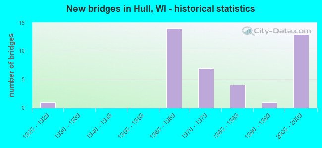
- New bridges - historical statistics
- 11920-1929
- 141960-1969
- 71970-1979
- 41980-1989
- 11990-1999
- 132000-2009

- Reconstructed bridges - Historical Statistics
- 11960-1969
- 01970-1979
- 01980-1989
- 01990-1999
- 32000-2009


- Bridge Condition - Deck
- 22.7%Very good
- 22.7%Good
- 45.5%Satisfactory
- 4.5%Fair
- 4.5%Poor

- Bridge Condition - Superstructure
- 18.2%Very good
- 45.5%Good
- 18.2%Satisfactory
- 18.2%Fair

- Bridge Condition - Substructure
- 9.1%Very good
- 45.5%Good
- 36.4%Satisfactory
- 4.5%Fair
- 4.5%Poor

- Bridge Condition - Channel
- 57.1%Very good
- 7.1%Good
- 7.1%Satisfactory
- 28.6%Poor

- Bridge Condition - Culverts
- 40.0%Good
- 20.0%Satisfactory
- 20.0%Fair
- 20.0%Poor
Find on map >> Show street view
Structure Number: B490021, Location: 0.7M E JCT USH B51 (Lat: 44.497192, Lng: -89.518700), Route carried "on" structure: County highway , Year Built: 1969, Status: Open, Structure Length: 5.47m (17.95ft), Average Daily Traffic: 18,000 (year 2019), Average Future Daily Traffic: 18,000 (year 2039), Design Load: H 20, Features Intersected: IH USH 51-IH 39, Facility Carried by Structure: CTH HH
Minimum Vertical Clearance: 30+ m (98+ ft), Kilometerpoint: 0.000, Lanes on structure: 5, Lanes under structure: 4, Owner: State Highway Agency, Approaching Roadway Width: 20.7m (67.9ft), Material/Design: Steel continuous, Design/Construction: Stringer/Multi-beam, Number Of Spans In Main Unit: 2, Length of Maximum Span: 27.6m (90.6ft), Curb-To-Curb Width: 21.3m (69.9ft), Out-to-Out Width: 22.3m (73.2ft)
Condition: Deck: Good, Superstructure: Satisfactory, Substructure: Satisfactory, Operating Rating: 57.0 metric tons, Method Used To Determine Operating Rating: Load Factor (LF), Inventory Rating: 34.0 metric tons, Method Used To Determine Inventory Rating: Load Factor (LF), Structural Evaluation: Equal to present minimum criteria, Deck Geometry: Somewhat better than minimum adequacy, Underclear: Somewhat better than minimum adequacy, Approach Roadway Alignment: Equal to present desirable criteria, Designated Inspection Frequency: Every 24 months, Inspection Date: July 2020, Deck Structure Type: Concrete Cast-file-Place, Wearing Surface/Protective System: Wearing Surface: Monolithic Concrete, Deck Protection: Epoxy Coated Reinforcing
Find on map >> Show street view
Structure Number: B490024, Location: 0.8M E JCT CTH YY (Lat: 44.523269, Lng: -89.527736), Route carried "on" structure: US 10, Year Built: 1968, Status: Open, Structure Length: 7.25m (23.79ft), Average Daily Traffic: 23,500 (year 2019), Truck Traffic: 3%, Average Future Daily Traffic: 52,490 (year 2040), Design Load: HS 20, Features Intersected: IH USH 51-IH 39
Minimum Vertical Clearance: 30+ m (98+ ft), Kilometerpoint: 0.000, Lanes on structure: 6, Lanes under structure: 5, Base Highway Network: Yes, Owner: State Highway Agency, Approaching Roadway Width: 27.7m (90.9ft), Skew: 33 degrees, Material/Design: Steel continuous, Design/Construction: Stringer/Multi-beam, Number Of Spans In Main Unit: 2, Length of Maximum Span: 35.5m (116.5ft), Curb or Sidewalk Widths: Left: 0.0m, Right: 2.0m (6.6ft), Curb-To-Curb Width: 25.8m (84.6ft), Out-to-Out Width: 29.9m (98.1ft)
Condition: Deck: Poor, Superstructure: Fair, Substructure: Poor, Operating Rating: 50.6 metric tons, Method Used To Determine Operating Rating: Load Factor (LF), Inventory Rating: 30.8 metric tons, Method Used To Determine Inventory Rating: Load Factor (LF), Structural Evaluation: Meets minimum limits, Deck Geometry: Somewhat better than minimum adequacy, Underclear: Somewhat better than minimum adequacy, Approach Roadway Alignment: Equal to present desirable criteria, Length Of Structure Improvement: 7.68m (25.20ft), Designated Inspection Frequency: Every 12 months, Inspection Date: August 2021, Bridge Improvement Cost: $1,229,000, Roadway Improvement Cost: $122,000, Total Project Cost: $1,843,000 ( Estimate for 2021), Deck Structure Type: Concrete Cast-file-Place, Wearing Surface/Protective System: Wearing Surface: Low Slump Concrete
Find on map >> Show street view
Structure Number: B490026, Location: 0.2M N JCT USH 10 TO E (Lat: 44.526981, Lng: -89.530564), Route carried "on" structure: Interstate 39, Year Built: 1969, Status: Open, Structure Length: 3.45m (11.32ft), Average Daily Traffic: 15,900 (year 2019), Truck Traffic: 16%, Average Future Daily Traffic: 27,132 (year 2039), Design Load: HS 20, Features Intersected: PLOVER RIVER
Minimum Vertical Clearance: 30+ m (98+ ft), Kilometerpoint: 0.000, Lanes on structure: 3, Base Highway Network: Yes, Owner: State Highway Agency, Approaching Roadway Width: 12.2m (40.0ft), Material/Design: Concrete continuous, Design/Construction: Slab, Number Of Spans In Main Unit: 3, Length of Maximum Span: 14.0m (45.9ft), Curb-To-Curb Width: 14.5m (47.6ft), Out-to-Out Width: 15.4m (50.5ft)
Condition: Deck: Fair, Superstructure: Fair, Substructure: Satisfactory, Channel: Very good, Operating Rating: 45.7 metric tons, Method Used To Determine Operating Rating: Load Factor (LF), Inventory Rating: 27.5 metric tons, Method Used To Determine Inventory Rating: Load Factor (LF), Structural Evaluation: Somewhat better than minimum adequacy, Deck Geometry: Meets minimum limits, Waterway Adequacy: Equal to present desirable criteria, Approach Roadway Alignment: Equal to present desirable criteria, Designated Inspection Frequency: Every 24 months, Inspection Date: July 2020, Deck Structure Type: Concrete Cast-file-Place, Wearing Surface/Protective System: Wearing Surface: Epoxy Overlay
Find on map >> Show street view
Structure Number: B490027, Location: 1.1M S JCT STH 66 TO E (Lat: 44.527003, Lng: -89.531250), Route carried "on" structure: Interstate 39, Year Built: 1969, Status: Open, Structure Length: 3.45m (11.32ft), Average Daily Traffic: 18,000 (year 2019), Truck Traffic: 15%, Average Future Daily Traffic: 18,400 (year 2039), Design Load: HS 20, Features Intersected: PLOVER RIVER
Minimum Vertical Clearance: 30+ m (98+ ft), Kilometerpoint: 0.000, Lanes on structure: 2, Base Highway Network: Yes, Owner: State Highway Agency, Approaching Roadway Width: 12.2m (40.0ft), Material/Design: Concrete continuous, Design/Construction: Slab, Number Of Spans In Main Unit: 3, Length of Maximum Span: 14.0m (45.9ft), Curb-To-Curb Width: 11.9m (39.0ft), Out-to-Out Width: 12.8m (42.0ft)
Condition: Deck: Satisfactory, Superstructure: Satisfactory, Substructure: Good, Channel: Very good, Operating Rating: 47.4 metric tons, Method Used To Determine Operating Rating: Load Factor (LF), Inventory Rating: 27.5 metric tons, Method Used To Determine Inventory Rating: Load Factor (LF), Structural Evaluation: Equal to present minimum criteria, Deck Geometry: Equal to present minimum criteria, Waterway Adequacy: Equal to present desirable criteria, Approach Roadway Alignment: Equal to present desirable criteria, Designated Inspection Frequency: Every 24 months, Inspection Date: July 2020, Deck Structure Type: Concrete Cast-file-Place, Wearing Surface/Protective System: Wearing Surface: Epoxy Overlay
Find on map >> Show street view
Structure Number: B490028, Location: 0.7M S JCT STH 66 (Lat: 44.530550, Lng: -89.534850), Route carried "on" structure: City street , Year Built: 1968, Status: Open, Structure Length: 5.61m (18.41ft), Average Daily Traffic: 1,500 (year 2019), Average Future Daily Traffic: 1,500 (year 2039), Design Load: H 15, Features Intersected: IH USH 51-IH 39, Facility Carried by Structure: LRD BARBARAS LANE
Minimum Vertical Clearance: 30+ m (98+ ft), Kilometerpoint: 0.000, Lanes on structure: 2, Lanes under structure: 4, Owner: State Highway Agency, Approaching Roadway Width: 7.9m (25.9ft), Skew: 1 degrees, Material/Design: Steel continuous, Design/Construction: Stringer/Multi-beam, Number Of Spans In Main Unit: 2, Length of Maximum Span: 28.2m (92.5ft), Curb-To-Curb Width: 8.2m (26.9ft), Out-to-Out Width: 9.3m (30.5ft)
Condition: Deck: Good, Superstructure: Good, Substructure: Satisfactory, Operating Rating: 35.9 metric tons, Method Used To Determine Operating Rating: Load Factor (LF), Inventory Rating: 21.1 metric tons, Method Used To Determine Inventory Rating: Load Factor (LF), Structural Evaluation: Somewhat better than minimum adequacy, Deck Geometry: Meets minimum limits, Underclear: Somewhat better than minimum adequacy, Approach Roadway Alignment: Equal to present desirable criteria, Designated Inspection Frequency: Every 24 months, Inspection Date: August 2020, Deck Structure Type: Concrete Cast-file-Place, Wearing Surface/Protective System: Wearing Surface: Low Slump Concrete
Find on map >> Show street view
Structure Number: B490029, Location: 1.4M N JCT USH 10 TO E (Lat: 44.540678, Lng: -89.544056), Route carried "on" structure: Interstate 39, Year Built: 1968, Status: Open, Structure Length: 4.86m (15.94ft), Average Daily Traffic: 15,900 (year 2019), Truck Traffic: 16%, Average Future Daily Traffic: 27,132 (year 2039), Design Load: HS 20, Features Intersected: STH 66
Minimum Vertical Clearance: 30+ m (98+ ft), Kilometerpoint: 0.000, Lanes on structure: 2, Lanes under structure: 6, Base Highway Network: Yes, Owner: State Highway Agency, Approaching Roadway Width: 11.6m (38.1ft), Material/Design: Prestressed concrete continuous, Design/Construction: Stringer/Multi-beam, Number Of Spans In Main Unit: 2, Length of Maximum Span: 23.9m (78.4ft), Curb-To-Curb Width: 11.9m (39.0ft), Out-to-Out Width: 12.8m (42.0ft)
Condition: Deck: Satisfactory, Superstructure: Fair, Substructure: Satisfactory, Operating Rating: 39.2 metric tons, Method Used To Determine Operating Rating: Load Factor (LF), Inventory Rating: 21.1 metric tons, Method Used To Determine Inventory Rating: Load Factor (LF), Structural Evaluation: Somewhat better than minimum adequacy, Deck Geometry: Equal to present minimum criteria, Underclear: Equal to present minimum criteria, Approach Roadway Alignment: Equal to present desirable criteria, Designated Inspection Frequency: Every 24 months, Inspection Date: August 2020, Deck Structure Type: Concrete Cast-file-Place, Wearing Surface/Protective System: Wearing Surface: Epoxy Overlay
Find on map >> Show street view
Structure Number: B49003, Location: 5.9M S JCT CTH X TO E (Lat: 44.540800, Lng: -89.544775), Route carried "on" structure: Interstate 39, Year Built: 1968, Status: Open, Structure Length: 4.86m (15.94ft), Average Daily Traffic: 16,400 (year 2019), Truck Traffic: 16%, Average Future Daily Traffic: 14,535 (year 2039), Design Load: HS 20, Features Intersected: STH 66
Minimum Vertical Clearance: 30+ m (98+ ft), Kilometerpoint: 0.000, Lanes on structure: 2, Lanes under structure: 6, Base Highway Network: Yes, Owner: State Highway Agency, Approaching Roadway Width: 11.6m (38.1ft), Material/Design: Prestressed concrete continuous, Design/Construction: Stringer/Multi-beam, Number Of Spans In Main Unit: 2, Length of Maximum Span: 23.9m (78.4ft), Curb-To-Curb Width: 11.9m (39.0ft), Out-to-Out Width: 12.8m (42.0ft)
Condition: Deck: Satisfactory, Superstructure: Fair, Substructure: Satisfactory, Operating Rating: 49.0 metric tons, Method Used To Determine Operating Rating: Load Factor (LF), Inventory Rating: 29.2 metric tons, Method Used To Determine Inventory Rating: Load Factor (LF), Structural Evaluation: Somewhat better than minimum adequacy, Deck Geometry: Equal to present minimum criteria, Underclear: Equal to present minimum criteria, Approach Roadway Alignment: Equal to present desirable criteria, Designated Inspection Frequency: Every 24 months, Inspection Date: August 2020, Deck Structure Type: Concrete Cast-file-Place, Wearing Surface/Protective System: Wearing Surface: Epoxy Overlay
Find on map >> Show street view
Structure Number: B490033, Location: 2.0M N JCT USH 10 TO W (Lat: 44.552128, Lng: -89.583961), Route carried "on" structure: City street , Year Built: 1969, Status: Open, Structure Length: 8.31m (27.26ft), Average Daily Traffic: 1,600 (year 2019), Average Future Daily Traffic: 1,600 (year 2039), Design Load: H 20, Features Intersected: IH USH 51-IH 39, Facility Carried by Structure: LRD N 2ND ST
Minimum Vertical Clearance: 30+ m (98+ ft), Kilometerpoint: 0.000, Lanes on structure: 2, Lanes under structure: 6, Owner: State Highway Agency, Approaching Roadway Width: 11.6m (38.1ft), Skew: 3 degrees, Material/Design: Steel continuous, Design/Construction: Stringer/Multi-beam, Number Of Spans In Main Unit: 2, Length of Maximum Span: 41.5m (136.2ft), Curb-To-Curb Width: 11.6m (38.1ft), Out-to-Out Width: 12.5m (41.0ft)
Condition: Deck: Satisfactory, Superstructure: Good, Substructure: Good, Operating Rating: 35.9 metric tons, Method Used To Determine Operating Rating: Load Factor (LF), Inventory Rating: 21.1 metric tons, Method Used To Determine Inventory Rating: Load Factor (LF), Structural Evaluation: Somewhat better than minimum adequacy, Deck Geometry: Equal to present minimum criteria, Underclear: Meets minimum limits, Approach Roadway Alignment: Equal to present desirable criteria, Designated Inspection Frequency: Every 24 months, Inspection Date: August 2020, Deck Structure Type: Concrete Cast-file-Place, Wearing Surface/Protective System: Wearing Surface: Low Slump Concrete
Find on map >> Show street view
Structure Number: B490041, Location: 0.4M E JCT CTH YY (Lat: 44.523292, Lng: -89.536817), Route carried "on" structure: State highway 66, Year Built: 1926, Year Reconstructed: 1969, Status: Open, Structure Length: 1.94m (6.36ft), Average Daily Traffic: 19,200 (year 2020), Truck Traffic: 3%, Average Future Daily Traffic: 22,800 (year 2040), Design Load: H 20, Features Intersected: PLOVER RIVER
Minimum Vertical Clearance: 30+ m (98+ ft), Kilometerpoint: 0.000, Lanes on structure: 4, Base Highway Network: Yes, Owner: State Highway Agency, Approaching Roadway Width: 7.9m (25.9ft), Skew: 30 degrees, Material/Design: Prestressed concrete, Design/Construction: Stringer/Multi-beam, Number Of Spans In Main Unit: 1, Length of Maximum Span: 18.8m (61.7ft), Curb or Sidewalk Widths: Left: 0.0m, Right: 2.0m (6.6ft), Curb-To-Curb Width: 7.9m (25.9ft), Out-to-Out Width: 21.6m (70.9ft)
Condition: Deck: Good, Superstructure: Good, Substructure: Fair, Channel: Very good, Operating Rating: 60.4 metric tons, Method Used To Determine Operating Rating: Load Factor (LF), Inventory Rating: 29.2 metric tons, Method Used To Determine Inventory Rating: Load Factor (LF), Structural Evaluation: Somewhat better than minimum adequacy, Deck Geometry: High priority of replacement, Waterway Adequacy: Equal to present desirable criteria, Approach Roadway Alignment: Equal to present desirable criteria, Length Of Structure Improvement: 2.38m (7.81ft), Designated Inspection Frequency: Every 24 months, Inspection Date: July 2020, Bridge Improvement Cost: $382,000, Roadway Improvement Cost: $38,000, Total Project Cost: $574,000 ( Estimate for 2021), Deck Structure Type: Concrete Cast-file-Place, Wearing Surface/Protective System: Wearing Surface: Epoxy Overlay, Deck Protection: Epoxy Coated Reinforcing
Find on map >> Show street view
Structure Number: B490053, Location: 1.5M N JCT USH B51 TO S (Lat: 44.567347, Lng: -89.595658), Route carried "on" structure: Interstate 39, Year Built: 1972, Year Reconstructed: 2006, Status: Open, Structure Length: 0.84m (2.76ft), Average Daily Traffic: 28,100 (year 2019), Truck Traffic: 16%, Average Future Daily Traffic: 25,880 (year 2039), Design Load: HS 20, Features Intersected: HAY MEADOW CREEK
Minimum Vertical Clearance: 30+ m (98+ ft), Kilometerpoint: 0.000, Lanes on structure: 6, Base Highway Network: Yes, Owner: State Highway Agency, Approaching Roadway Width: 24.4m (80.1ft), Skew: 1 degrees, Material/Design: Concrete continuous, Design/Construction: Culvert, Number Of Spans In Main Unit: 3, Length of Maximum Span: 2.4m (7.9ft)
Condition: Channel: Satisfactory, Culverts: Good, Operating Rating: 53.9 metric tons, Method Used To Determine Operating Rating: Field evaluation and documented engineering judgment, Inventory Rating: 32.4 metric tons, Method Used To Determine Inventory Rating: Field evaluation and documented engineering judgment, Structural Evaluation: Better than present minimum criteria, Waterway Adequacy: Equal to present desirable criteria, Approach Roadway Alignment: Equal to present desirable criteria, Designated Inspection Frequency: Every 24 months, Inspection Date: August 2020, Deck Structure Type: Concrete Cast-file-Place, Wearing Surface/Protective System: Wearing Surface: Bituminous
Find on map >> Show street view
Structure Number: B490054, Location: 2.4M S JCT CTH X (Lat: 44.569986, Lng: -89.598747), Route carried "on" structure: City street , Year Built: 1972, Year Reconstructed: 2006, Status: Open, Structure Length: 8.75m (28.71ft), Average Daily Traffic: 2,300 (year 2019), Average Future Daily Traffic: 2,300 (year 2039), Design Load: H 20, Features Intersected: IH USH 51-IH 39, Facility Carried by Structure: LRD CASMIR RD
Minimum Vertical Clearance: 30+ m (98+ ft), Kilometerpoint: 0.000, Lanes on structure: 2, Lanes under structure: 4, Owner: State Highway Agency, Approaching Roadway Width: 12.2m (40.0ft), Skew: 2 degrees, Material/Design: Steel continuous, Design/Construction: Stringer/Multi-beam, Number Of Spans In Main Unit: 2, Length of Maximum Span: 43.9m (144.0ft), Curb-To-Curb Width: 12.2m (40.0ft), Out-to-Out Width: 13.0m (42.7ft)
Condition: Deck: Satisfactory, Superstructure: Good, Substructure: Good, Operating Rating: 62.1 metric tons, Method Used To Determine Operating Rating: Load Factor (LF), Inventory Rating: 37.3 metric tons, Method Used To Determine Inventory Rating: Load Factor (LF), Structural Evaluation: Better than present minimum criteria, Deck Geometry: Equal to present minimum criteria, Underclear: Equal to present minimum criteria, Approach Roadway Alignment: Equal to present desirable criteria, Designated Inspection Frequency: Every 24 months, Inspection Date: August 2020, Deck Structure Type: Concrete Cast-file-Place, Wearing Surface/Protective System: Wearing Surface: Monolithic Concrete, Deck Protection: Epoxy Coated Reinforcing
Find on map >> Show street view
Structure Number: B490055, Location: 5.2M S JCT CTH DB (Lat: 44.594856, Lng: -89.614125), Route carried "on" structure: County highway , Year Built: 1971, Year Reconstructed: 2008, Status: Open, Structure Length: 7.92m (25.98ft), Average Daily Traffic: 590 (year 2019), Average Future Daily Traffic: 590 (year 2039), Design Load: HS 20, Features Intersected: IH USH 51-IH 39, Facility Carried by Structure: CTH X
Minimum Vertical Clearance: 30+ m (98+ ft), Kilometerpoint: 0.000, Lanes on structure: 2, Lanes under structure: 6, Owner: State Highway Agency, Approaching Roadway Width: 13.4m (44.0ft), Material/Design: Steel continuous, Design/Construction: Stringer/Multi-beam, Number Of Spans In Main Unit: 2, Length of Maximum Span: 39.6m (129.9ft), Curb-To-Curb Width: 13.4m (44.0ft), Out-to-Out Width: 14.2m (46.6ft)
Condition: Deck: Good, Superstructure: Good, Substructure: Satisfactory, Operating Rating: 63.7 metric tons, Method Used To Determine Operating Rating: Load Factor (LF), Inventory Rating: 37.3 metric tons, Method Used To Determine Inventory Rating: Load Factor (LF), Structural Evaluation: Equal to present minimum criteria, Deck Geometry: Superior to present desirable criteria, Underclear: Somewhat better than minimum adequacy, Approach Roadway Alignment: Equal to present desirable criteria, Designated Inspection Frequency: Every 24 months, Inspection Date: August 2020, Deck Structure Type: Concrete Cast-file-Place, Wearing Surface/Protective System: Wearing Surface: Monolithic Concrete
Find on map >> Show street view
Structure Number: B490062, Location: 0.7M S JCT USH 51 (Lat: 44.563656, Lng: -89.597717), Route carried "on" structure: City street , Year Built: 1971, Status: Open, Structure Length: 0.82m (2.69ft), Average Daily Traffic: 300 (year 2019), Average Future Daily Traffic: 330 (year 2039), Design Load: H 15, Features Intersected: HAY MEADOW CREEK, Facility Carried by Structure: LRD OLD WAUSAU RD
Minimum Vertical Clearance: 30+ m (98+ ft), Kilometerpoint: 0.000, Lanes on structure: 2, Owner: Town or Township Highway Agency, Approaching Roadway Width: 12.8m (42.0ft), Material/Design: Concrete continuous, Design/Construction: Culvert, Number Of Spans In Main Unit: 3, Length of Maximum Span: 2.7m (8.9ft)
Condition: Channel: Poor, Culverts: Good, Operating Rating: 53.9 metric tons, Method Used To Determine Operating Rating: Field evaluation and documented engineering judgment, Inventory Rating: 24.3 metric tons, Method Used To Determine Inventory Rating: Field evaluation and documented engineering judgment, Structural Evaluation: Equal to present minimum criteria, Waterway Adequacy: Equal to present desirable criteria, Approach Roadway Alignment: Equal to present desirable criteria, Designated Inspection Frequency: Every 24 months, Inspection Date: September 2020, Deck Structure Type: Concrete Cast-file-Place, Wearing Surface/Protective System: Wearing Surface: Bituminous
Find on map >> Show street view
Structure Number: B490065, Location: 2.0M S JCT CTH X (Lat: 44.570042, Lng: -89.592147), Route carried "on" structure: City street , Year Built: 1984, Status: Open, Structure Length: 1.01m (3.31ft), Average Daily Traffic: 1,659 (year 2019), Average Future Daily Traffic: 1,824 (year 2039), Design Load: H 20, Features Intersected: HAY MEADOW CREEK, Facility Carried by Structure: LRD N SECOND STREE
Minimum Vertical Clearance: 30+ m (98+ ft), Kilometerpoint: 0.000, Lanes on structure: 2, Owner: Town or Township Highway Agency, Approaching Roadway Width: 12.2m (40.0ft), Material/Design: Concrete continuous, Design/Construction: Culvert, Number Of Spans In Main Unit: 3, Length of Maximum Span: 3.0m (9.8ft)
Condition: Channel: Poor, Culverts: Satisfactory, Operating Rating: 53.9 metric tons, Method Used To Determine Operating Rating: Field evaluation and documented engineering judgment, Inventory Rating: 32.4 metric tons, Method Used To Determine Inventory Rating: Field evaluation and documented engineering judgment, Structural Evaluation: Equal to present minimum criteria, Waterway Adequacy: Equal to present desirable criteria, Approach Roadway Alignment: Equal to present minimum criteria, Designated Inspection Frequency: Every 24 months, Inspection Date: September 2020, Deck Structure Type: Concrete Cast-file-Place, Wearing Surface/Protective System: Wearing Surface: Bituminous
Find on map >> Show street view
Structure Number: B490073, Location: 0.1M E JCT CTH Y (Lat: 44.576144, Lng: -89.501239), Route carried "on" structure: State highway 66, Year Built: 1985, Status: Open, Structure Length: 1.58m (5.18ft), Average Daily Traffic: 4,400 (year 2019), Truck Traffic: 6%, Average Future Daily Traffic: 5,330 (year 2040), Design Load: HS 20, Features Intersected: PLOVER RIVER
Minimum Vertical Clearance: 30+ m (98+ ft), Kilometerpoint: 0.000, Lanes on structure: 2, Owner: State Highway Agency, Approaching Roadway Width: 12.2m (40.0ft), Material/Design: Prestressed concrete, Design/Construction: Stringer/Multi-beam, Number Of Spans In Main Unit: 1, Length of Maximum Span: 15.6m (51.2ft), Curb or Sidewalk Widths: Left: 0.0m, Right: 2.0m (6.6ft), Curb-To-Curb Width: 13.1m (43.0ft), Out-to-Out Width: 15.7m (51.5ft)
Condition: Deck: Good, Superstructure: Very good, Substructure: Good, Channel: Good, Operating Rating: 62.1 metric tons, Method Used To Determine Operating Rating: Load Factor (LF), Inventory Rating: 34.0 metric tons, Method Used To Determine Inventory Rating: Load Factor (LF), Structural Evaluation: Better than present minimum criteria, Deck Geometry: Equal to present minimum criteria, Waterway Adequacy: Equal to present desirable criteria, Approach Roadway Alignment: Equal to present desirable criteria, Designated Inspection Frequency: Every 24 months, Inspection Date: September 2021, Deck Structure Type: Concrete Cast-file-Place, Wearing Surface/Protective System: Wearing Surface: Epoxy Overlay, Deck Protection: Epoxy Coated Reinforcing
Find on map >> Show street view
Structure Number: B490074, Location: 0.2M E JCT CTH Y (Lat: 44.576236, Lng: -89.500536), Route carried "on" structure: State highway 66, Year Built: 1985, Status: Open, Structure Length: 0.77m (2.53ft), Average Daily Traffic: 3,400 (year 2019), Truck Traffic: 6%, Average Future Daily Traffic: 5,330 (year 2040), Design Load: HS 20, Features Intersected: PLOVER RIVER
Minimum Vertical Clearance: 30+ m (98+ ft), Kilometerpoint: 0.000, Lanes on structure: 2, Owner: State Highway Agency, Approaching Roadway Width: 12.2m (40.0ft), Skew: 3 degrees, Material/Design: Concrete, Design/Construction: Slab, Number Of Spans In Main Unit: 1, Length of Maximum Span: 7.6m (24.9ft), Curb or Sidewalk Widths: Left: 0.0m, Right: 2.0m (6.6ft), Curb-To-Curb Width: 12.2m (40.0ft), Out-to-Out Width: 15.7m (51.5ft)
Condition: Deck: Satisfactory, Superstructure: Satisfactory, Substructure: Good, Channel: Very good, Operating Rating: 57.0 metric tons, Method Used To Determine Operating Rating: Load Factor (LF), Inventory Rating: 34.0 metric tons, Method Used To Determine Inventory Rating: Load Factor (LF), Structural Evaluation: Equal to present minimum criteria, Deck Geometry: Equal to present minimum criteria, Waterway Adequacy: Equal to present desirable criteria, Approach Roadway Alignment: Equal to present desirable criteria, Designated Inspection Frequency: Every 24 months, Underwater Inspection Frequency: Every 72 months, Inspection Date: September 2021, Underwater Inspection Date: July 2020, Deck Structure Type: Concrete Cast-file-Place, Wearing Surface/Protective System: Wearing Surface: Epoxy Overlay, Deck Protection: Epoxy Coated Reinforcing
Find on map >> Show street view
Structure Number: B490076, Location: 1.8M W JCT USH 51 (Lat: 44.569544, Lng: -89.634019), Route carried "on" structure: City street , Year Built: 1988, Status: Open, Structure Length: 1.58m (5.18ft), Average Daily Traffic: 51 (year 2019), Average Future Daily Traffic: 52 (year 2039), Design Load: HS 20, Features Intersected: WISCONSIN R BACKWATER, Facility Carried by Structure: LRD WALKUSH RD (DE
Minimum Vertical Clearance: 30+ m (98+ ft), Kilometerpoint: 0.000, Lanes on structure: 2, Owner: Town or Township Highway Agency, Approaching Roadway Width: 7.3m (24.0ft), Material/Design: Prestressed concrete, Design/Construction: Box Beam or Girders - Multiple, Number Of Spans In Main Unit: 1, Length of Maximum Span: 15.2m (49.9ft), Curb-To-Curb Width: 7.3m (24.0ft), Out-to-Out Width: 7.5m (24.6ft)
Condition: Deck: Satisfactory, Superstructure: Very good, Substructure: Satisfactory, Channel: Very good, Operating Rating: 65.0 metric tons, Method Used To Determine Operating Rating: Load Factor (LF), Inventory Rating: 37.3 metric tons, Method Used To Determine Inventory Rating: Load Factor (LF), Structural Evaluation: Equal to present minimum criteria, Deck Geometry: Equal to present minimum criteria, Waterway Adequacy: Equal to present desirable criteria, Approach Roadway Alignment: Equal to present desirable criteria, Designated Inspection Frequency: Every 24 months, Inspection Date: September 2020, Deck Structure Type: Concrete Cast-file-Place, Wearing Surface/Protective System: Wearing Surface: Monolithic Concrete, Deck Protection: Epoxy Coated Reinforcing
Find on map >> Show street view
Structure Number: B49014, Location: 0.8M E JCT CTH E TO S (Lat: 44.528631, Lng: -89.615333), Route carried "on" structure: County highway , Year Built: 2006, Status: Open, Structure Length: 2.82m (9.25ft), Average Daily Traffic: 8,569 (year 2019), Average Future Daily Traffic: 9,425 (year 2040), Design Load: HS 20, Features Intersected: WISCONSIN RIVER OVRFLW, Facility Carried by Structure: CTH HH
Minimum Vertical Clearance: 30+ m (98+ ft), Kilometerpoint: 0.000, Lanes on structure: 2, Owner: County Highway Agency, Approaching Roadway Width: 13.4m (44.0ft), Material/Design: Concrete continuous, Design/Construction: Slab, Number Of Spans In Main Unit: 2, Length of Maximum Span: 13.7m (44.9ft), Curb-To-Curb Width: 13.4m (44.0ft), Out-to-Out Width: 14.2m (46.6ft)
Condition: Deck: Satisfactory, Superstructure: Satisfactory, Substructure: Satisfactory, Channel: Very good, Operating Rating: 68.6 metric tons, Method Used To Determine Operating Rating: Load Factor (LF), Inventory Rating: 40.5 metric tons, Method Used To Determine Inventory Rating: Load Factor (LF), Structural Evaluation: Equal to present minimum criteria, Deck Geometry: Equal to present minimum criteria, Waterway Adequacy: Equal to present desirable criteria, Approach Roadway Alignment: Equal to present desirable criteria, Designated Inspection Frequency: Every 24 months, Inspection Date: August 2021, Deck Structure Type: Concrete Cast-file-Place, Wearing Surface/Protective System: Wearing Surface: Monolithic Concrete
Find on map >> Show street view
Structure Number: B490143, Location: 0.75M W JCT IH39 (Lat: 44.595917, Lng: -89.631194), Route carried "on" structure: US 10, Year Built: 2009, Status: Open, Structure Length: 12.80m (41.99ft), Average Daily Traffic: 3,150 (year 2018), Average Future Daily Traffic: 9,700 (year 2040), Design Load: HS 25 or greater, Features Intersected: WETLANDS
Minimum Vertical Clearance: 30+ m (98+ ft), Kilometerpoint: 0.000, Lanes on structure: 2, Base Highway Network: Yes, Owner: State Highway Agency, Approaching Roadway Width: 12.2m (40.0ft), Skew: 2 degrees, Material/Design: Prestressed concrete continuous, Design/Construction: Stringer/Multi-beam, Number Of Spans In Main Unit: 3, Length of Maximum Span: 42.4m (139.1ft), Curb-To-Curb Width: 12.2m (40.0ft), Out-to-Out Width: 13.0m (42.7ft)
Condition: Deck: Satisfactory, Superstructure: Good, Substructure: Good, Channel: Very good, Operating Rating: 82.0 metric tons, Method Used To Determine Operating Rating: Load Factor (LF), Inventory Rating: 38.9 metric tons, Method Used To Determine Inventory Rating: Load Factor (LF), Structural Evaluation: Better than present minimum criteria, Deck Geometry: Better than present minimum criteria, Waterway Adequacy: Superior to present desirable criteria, Approach Roadway Alignment: Equal to present desirable criteria, Designated Inspection Frequency: Every 24 months, Inspection Date: June 2021, Deck Structure Type: Concrete Cast-file-Place, Wearing Surface/Protective System: Wearing Surface: Epoxy Overlay
Find on map >> Show street view
Structure Number: B490144, Location: 0.75M W JCT IH39 (Lat: 44.596444, Lng: -89.629361), Route carried "on" structure: US 10, Year Built: 2009, Status: Open, Structure Length: 12.80m (41.99ft), Average Daily Traffic: 3,150 (year 2018), Average Future Daily Traffic: 9,700 (year 2040), Design Load: HS 25 or greater, Features Intersected: WETLANDS
Minimum Vertical Clearance: 30+ m (98+ ft), Kilometerpoint: 0.000, Lanes on structure: 2, Base Highway Network: Yes, Owner: State Highway Agency, Approaching Roadway Width: 12.2m (40.0ft), Skew: 2 degrees, Material/Design: Prestressed concrete continuous, Design/Construction: Stringer/Multi-beam, Number Of Spans In Main Unit: 3, Length of Maximum Span: 42.4m (139.1ft), Curb-To-Curb Width: 12.2m (40.0ft), Out-to-Out Width: 13.0m (42.7ft)
Condition: Deck: Satisfactory, Superstructure: Good, Substructure: Good, Channel: Very good, Operating Rating: 82.0 metric tons, Method Used To Determine Operating Rating: Load Factor (LF), Inventory Rating: 38.9 metric tons, Method Used To Determine Inventory Rating: Load Factor (LF), Structural Evaluation: Better than present minimum criteria, Deck Geometry: Better than present minimum criteria, Waterway Adequacy: Superior to present desirable criteria, Approach Roadway Alignment: Equal to present desirable criteria, Designated Inspection Frequency: Every 24 months, Inspection Date: June 2021, Deck Structure Type: Concrete Cast-file-Place, Wearing Surface/Protective System: Wearing Surface: Epoxy Overlay
Find on map >> Show street view
Structure Number: B490145, Location: 5.15 MI. E JCT STH 34 (Lat: 44.597333, Lng: -89.618139), Route carried "on" structure: Ramp Interstate 39, Year Built: 2008, Status: Open, Structure Length: 3.78m (12.40ft), Average Daily Traffic: 5,300 (year 2020), Truck Traffic: 3%, Average Future Daily Traffic: 4,550 (year 2040), Design Load: HS 25 or greater, Features Intersected: LRD SCENIC DRIVE N, Facility Carried by Structure: IH 10EB RAMP TO I-
Minimum Vertical Clearance: 30+ m (98+ ft), Kilometerpoint: 0.000, Lanes on structure: 4, Lanes under structure: 2, Owner: State Highway Agency, Approaching Roadway Width: 8.8m (28.9ft), Skew: 30 degrees, Material/Design: Prestressed concrete, Design/Construction: Stringer/Multi-beam, Number Of Spans In Main Unit: 1, Length of Maximum Span: 36.6m (120.1ft), Curb-To-Curb Width: 8.8m (28.9ft), Out-to-Out Width: 19.1m (62.7ft)
Condition: Deck: Very good, Superstructure: Very good, Substructure: Very good, Operating Rating: 96.3 metric tons, Method Used To Determine Operating Rating: Load Factor (LF), Inventory Rating: 47.0 metric tons, Method Used To Determine Inventory Rating: Load Factor (LF), Structural Evaluation: Equal to present desirable criteria, Deck Geometry: High priority of replacement, Underclear: Meets minimum limits, Approach Roadway Alignment: Equal to present desirable criteria, Length Of Structure Improvement: 4.21m (13.81ft), Designated Inspection Frequency: Every 48 months, Inspection Date: June 2021, Bridge Improvement Cost: $525,000, Roadway Improvement Cost: $52,000, Total Project Cost: $787,000 ( Estimate for 2021), Deck Structure Type: Concrete Cast-file-Place, Wearing Surface/Protective System: Wearing Surface: Epoxy Overlay, Deck Protection: Epoxy Coated Reinforcing
Find on map >> Show street view
Structure Number: B490146, Location: 3.5 MI EAST OF STH 34 TO (Lat: 44.597167, Lng: -89.618083), Route carried "on" structure: Ramp Interstate 39, Year Built: 2009, Status: Open, Structure Length: 3.32m (10.89ft), Average Daily Traffic: 2,400 (year 2019), Average Future Daily Traffic: 4,650 (year 2040), Design Load: HS 25 or greater, Features Intersected: LRD SCENIC DRIVE, Facility Carried by Structure: IH USH10 EB RAMP T
Minimum Vertical Clearance: 30+ m (98+ ft), Kilometerpoint: 0.000, Lanes on structure: 2, Lanes under structure: 2, Owner: State Highway Agency, Approaching Roadway Width: 8.2m (26.9ft), Skew: 1 degrees, Material/Design: Prestressed concrete, Design/Construction: Stringer/Multi-beam, Number Of Spans In Main Unit: 1, Length of Maximum Span: 32.0m (105.0ft), Curb-To-Curb Width: 8.7m (28.5ft), Out-to-Out Width: 9.5m (31.2ft)
Condition: Deck: Very good, Superstructure: Very good, Substructure: Very good, Operating Rating: 99.6 metric tons, Method Used To Determine Operating Rating: Load Factor (LF), Inventory Rating: 50.2 metric tons, Method Used To Determine Inventory Rating: Load Factor (LF), Structural Evaluation: Equal to present desirable criteria, Deck Geometry: Meets minimum limits, Underclear: Meets minimum limits, Approach Roadway Alignment: Equal to present desirable criteria, Designated Inspection Frequency: Every 48 months, Inspection Date: June 2021, Deck Structure Type: Concrete Cast-file-Place, Wearing Surface/Protective System: Wearing Surface: Epoxy Overlay, Deck Protection: Epoxy Coated Reinforcing
Find on map >> Show street view
Structure Number: B490147, Location: US 10 AND I39 SYSTEM RAMP (Lat: 44.598444, Lng: -89.617694), Route carried "on" structure: Interstate 39, Year Built: 2009, Status: Open, Structure Length: 4.75m (15.58ft), Average Daily Traffic: 280 (year 2020), Average Future Daily Traffic: 325 (year 2040), Design Load: HS 25 or greater, Features Intersected: LRD SCENIC DRIVE
Minimum Vertical Clearance: 30+ m (98+ ft), Kilometerpoint: 0.000, Lanes on structure: 1, Lanes under structure: 2, Base Highway Network: Yes, Owner: State Highway Agency, Approaching Roadway Width: 8.2m (26.9ft), Skew: 24 degrees, Material/Design: Prestressed concrete, Design/Construction: Stringer/Multi-beam, Number Of Spans In Main Unit: 1, Length of Maximum Span: 45.7m (149.9ft), Curb-To-Curb Width: 10.4m (34.1ft), Out-to-Out Width: 11.3m (37.1ft)
Condition: Deck: Very good, Superstructure: Good, Substructure: Good, Inventory Rating: 48.6 metric tons, Method Used To Determine Inventory Rating: Load Factor (LF), Structural Evaluation: Better than present minimum criteria, Deck Geometry: Better than present minimum criteria, Underclear: Meets minimum limits, Approach Roadway Alignment: Equal to present minimum criteria, Designated Inspection Frequency: Every 48 months, Inspection Date: June 2021, Deck Structure Type: Concrete Cast-file-Place, Wearing Surface/Protective System: Wearing Surface: Epoxy Overlay, Deck Protection: Epoxy Coated Reinforcing
Find on map >> Show street view
Structure Number: B490148, Location: 5.25 MI E. JCT STH 34 (Lat: 44.597583, Lng: -89.615833), Route carried "on" structure: Ramp Interstate 39, Year Built: 2008, Status: Open, Structure Length: 8.35m (27.40ft), Average Daily Traffic: 5,300 (year 2020), Average Future Daily Traffic: 4,550 (year 2040), Design Load: HS 25 or greater, Features Intersected: IH 39, Facility Carried by Structure: IH USH10 EB RAMP T
Minimum Vertical Clearance: 30+ m (98+ ft), Kilometerpoint: 0.000, Lanes on structure: 2, Lanes under structure: 4, Owner: State Highway Agency, Approaching Roadway Width: 8.8m (28.9ft), Skew: 31 degrees, Material/Design: Prestressed concrete continuous, Design/Construction: Stringer/Multi-beam, Number Of Spans In Main Unit: 2, Length of Maximum Span: 41.1m (134.8ft), Curb-To-Curb Width: 8.8m (28.9ft), Out-to-Out Width: 19.1m (62.7ft)
Condition: Deck: Very good, Superstructure: Good, Substructure: Good, Operating Rating: 76.7 metric tons, Method Used To Determine Operating Rating: Load Factor (LF), Inventory Rating: 42.1 metric tons, Method Used To Determine Inventory Rating: Load Factor (LF), Structural Evaluation: Better than present minimum criteria, Deck Geometry: Meets minimum limits, Underclear: Equal to present minimum criteria, Approach Roadway Alignment: Equal to present desirable criteria, Designated Inspection Frequency: Every 48 months, Inspection Date: June 2021, Deck Structure Type: Concrete Cast-file-Place, Wearing Surface/Protective System: Wearing Surface: Epoxy Overlay, Deck Protection: Epoxy Coated Reinforcing
Find on map >> Show street view
Structure Number: B490149, Location: IH39/USH10 SYSTEM INTERCH (Lat: 44.597611, Lng: -89.608861), Route carried "on" structure: Ramp Interstate 39, Year Built: 2009, Status: Open, Structure Length: 4.02m (13.19ft), Average Daily Traffic: 5,300 (year 2020), Average Future Daily Traffic: 4,550 (year 2040), Design Load: HS 25 or greater, Features Intersected: CTH X
Minimum Vertical Clearance: 30+ m (98+ ft), Kilometerpoint: 0.000, Lanes on structure: 2, Lanes under structure: 2, Owner: State Highway Agency, Approaching Roadway Width: 18.9m (62.0ft), Skew: 30 degrees, Material/Design: Prestressed concrete, Design/Construction: Stringer/Multi-beam, Number Of Spans In Main Unit: 1, Length of Maximum Span: 39.0m (128.0ft), Curb-To-Curb Width: 19.5m (64.0ft), Out-to-Out Width: 21.0m (68.9ft)
Condition: Deck: Very good, Superstructure: Good, Substructure: Good, Inventory Rating: 48.6 metric tons, Method Used To Determine Inventory Rating: Load Factor (LF), Structural Evaluation: Better than present minimum criteria, Deck Geometry: Superior to present desirable criteria, Underclear: Equal to present minimum criteria, Approach Roadway Alignment: Equal to present desirable criteria, Designated Inspection Frequency: Every 48 months, Inspection Date: June 2021, Deck Structure Type: Concrete Cast-file-Place, Wearing Surface/Protective System: Wearing Surface: Epoxy Overlay, Deck Protection: Epoxy Coated Reinforcing
Find on map >> Show street view
Structure Number: P490913, Location: 2.3M S JCT STH 66 (Lat: 44.594153, Lng: -89.284089), Route carried "on" structure: County highway , Year Built: 1979, Status: Open, Structure Length: 0.70m (2.30ft), Average Daily Traffic: 1,065 (year 2019), Average Future Daily Traffic: 1,171 (year 2040), Design Load: H 20, Features Intersected: FLUME CREEK, Facility Carried by Structure: CTH A
Minimum Vertical Clearance: 30+ m (98+ ft), Kilometerpoint: 0.000, Lanes on structure: 2, Owner: County Highway Agency, Approaching Roadway Width: 10.4m (34.1ft), Material/Design: Steel, Design/Construction: Culvert, Number Of Spans In Main Unit: 2, Length of Maximum Span: 3.0m (9.8ft)
Condition: Channel: Poor, Culverts: Poor, Operating Rating: 53.9 metric tons, Method Used To Determine Operating Rating: Field evaluation and documented engineering judgment, Inventory Rating: 24.3 metric tons, Method Used To Determine Inventory Rating: Field evaluation and documented engineering judgment, Structural Evaluation: Meets minimum limits, Waterway Adequacy: Equal to present desirable criteria, Approach Roadway Alignment: Equal to present desirable criteria, Length Of Structure Improvement: 1.16m (3.81ft), Designated Inspection Frequency: Every 12 months, Inspection Date: August 2021, Bridge Improvement Cost: $123,000, Roadway Improvement Cost: $12,000, Total Project Cost: $184,000 ( Estimate for 2021), Deck Structure Type: Corrugated Steel, Wearing Surface/Protective System: Wearing Surface: Bituminous
Find on map >> Show street view
Structure Number: P490917, Location: 2.5M N JCT USH 51 (Lat: 44.584683, Lng: -89.570517), Route carried "on" structure: City street , Year Built: 1994, Status: Open, Structure Length: 1.20m (3.94ft), Average Daily Traffic: 1,659 (year 2019), Average Future Daily Traffic: 1,824 (year 2039), Design Load: HS 20, Features Intersected: HAY MEADOW CREEK, Facility Carried by Structure: LRD N RESERVE DRIV
Minimum Vertical Clearance: 30+ m (98+ ft), Kilometerpoint: 0.000, Lanes on structure: 2, Owner: Town or Township Highway Agency, Approaching Roadway Width: 9.1m (29.9ft), Skew: 1 degrees, Material/Design: Aluminum, Iron, Design/Construction: Culvert, Number Of Spans In Main Unit: 4, Length of Maximum Span: 2.2m (7.2ft)
Condition: Channel: Poor, Culverts: Fair, Operating Rating: 53.9 metric tons, Method Used To Determine Operating Rating: Field evaluation and documented engineering judgment, Inventory Rating: 32.4 metric tons, Method Used To Determine Inventory Rating: Field evaluation and documented engineering judgment, Structural Evaluation: Somewhat better than minimum adequacy, Waterway Adequacy: Equal to present desirable criteria, Approach Roadway Alignment: Equal to present desirable criteria, Designated Inspection Frequency: Every 24 months, Inspection Date: September 2020, Deck Structure Type: Corrugated Steel, Wearing Surface/Protective System: Wearing Surface: Bituminous
Find on map >> Show street view
Structure Number: B490024, Location: 6.7M N JCT STH 54 TO E (Lat: 44.523269, Lng: -89.527736), Route carried "under" structure: Interstate 39, Year Built: 1968, Structure Length: 0. m, Average Daily Traffic: 27,400 (year 2019), Truck Traffic: 15%, Features Intersected: IH USH 51-IH 39, Facility Carried by Structure: USH 10
Minimum Vertical Clearance: 4.90m (16.08ft), Kilometerpoint: 0.000, Lanes on structure: 6, Lanes under structure: 5, Material/Design: Steel continuous, Design/Construction: Stringer/Multi-beam, Length of Maximum Span: 35.5m (116.5ft)
Find on map >> Show street view
Structure Number: B490028, Location: 0.5M N JCT USH 10 TO E (Lat: 44.530550, Lng: -89.534850), Route carried "under" structure: Interstate 39, Year Built: 1968, Structure Length: 0. m, Average Daily Traffic: 28,400 (year 2019), Truck Traffic: 15%, Features Intersected: IH USH 51-IH 39, Facility Carried by Structure: LRD BARBARAS LANE
Minimum Vertical Clearance: 4.94m (16.21ft), Kilometerpoint: 0.000, Lanes on structure: 2, Lanes under structure: 4, Material/Design: Steel continuous, Design/Construction: Stringer/Multi-beam, Length of Maximum Span: 28.2m (92.5ft)
Find on map >> Show street view
Structure Number: B490029, Location: 1.8M E JCT USH 10 (Lat: 44.540678, Lng: -89.544056), Route carried "under" structure: State highway 66, Year Built: 1968, Structure Length: 0. m, Average Daily Traffic: 14,200 (year 2019), Truck Traffic: 3%, Features Intersected: STH 66, Facility Carried by Structure: IH USH51-IH39NB
Minimum Vertical Clearance: 4.52m (14.83ft), Kilometerpoint: 0.000, Lanes on structure: 2, Lanes under structure: 6, Material/Design: Prestressed concrete continuous, Design/Construction: Stringer/Multi-beam, Length of Maximum Span: 23.9m (78.4ft)
Find on map >> Show street view
Structure Number: B49003, Location: 1.7M E JCT USH 10 (Lat: 44.540800, Lng: -89.544775), Route carried "under" structure: State highway 66, Year Built: 1968, Structure Length: 0. m, Average Daily Traffic: 17,900 (year 2019), Truck Traffic: 3%, Features Intersected: STH 66, Facility Carried by Structure: IH USH51-IH39SB
Minimum Vertical Clearance: 4.52m (14.83ft), Kilometerpoint: 0.000, Lanes on structure: 2, Lanes under structure: 6, Material/Design: Prestressed concrete continuous, Design/Construction: Stringer/Multi-beam, Length of Maximum Span: 23.9m (78.4ft)
Find on map >> Show street view
Structure Number: B490033, Location: 0.3M N JCT USH B51 TO S (Lat: 44.552128, Lng: -89.583961), Route carried "under" structure: Interstate 39, Year Built: 1969, Structure Length: 0. m, Average Daily Traffic: 26,900 (year 2019), Truck Traffic: 16%, Features Intersected: IH USH 51-IH 39, Facility Carried by Structure: LRD N 2ND ST
Minimum Vertical Clearance: 4.93m (16.17ft), Kilometerpoint: 0.000, Lanes on structure: 2, Lanes under structure: 6, Material/Design: Steel continuous, Design/Construction: Stringer/Multi-beam, Length of Maximum Span: 41.5m (136.2ft)
Find on map >> Show street view
Structure Number: B49004, Location: 0.5M N JCT STH 66 TO E (Lat: 44.544689, Lng: -89.548672), Route carried "under" structure: Interstate 39, Year Built: 1969, Structure Length: 0. m, Average Daily Traffic: 27,600 (year 2019), Truck Traffic: 15%, Features Intersected: IH USH 51-IH 39, Facility Carried by Structure: LRD WILSHIRE BLVD
Minimum Vertical Clearance: 4.90m (16.08ft), Kilometerpoint: 0.000, Lanes on structure: 2, Lanes under structure: 4, Material/Design: Steel continuous, Design/Construction: Stringer/Multi-beam, Length of Maximum Span: 35.2m (115.5ft)
Find on map >> Show street view
Structure Number: B490054, Location: 1.7M N JCT USH B51 TO S (Lat: 44.569986, Lng: -89.598747), Route carried "under" structure: Interstate 39, Year Built: 1972, Structure Length: 0. m, Average Daily Traffic: 26,900 (year 2019), Truck Traffic: 18%, Features Intersected: IH USH 51-IH 39, Facility Carried by Structure: LRD CASMIR RD
Minimum Vertical Clearance: 5.09m (16.70ft), Kilometerpoint: 0.000, Lanes on structure: 2, Lanes under structure: 4, Material/Design: Steel continuous, Design/Construction: Stringer/Multi-beam, Length of Maximum Span: 43.9m (144.0ft)
Find on map >> Show street view
Structure Number: B490055, Location: 3.6M N JCT USH B51 TO S (Lat: 44.594856, Lng: -89.614125), Route carried "under" structure: Interstate 39, Year Built: 1971, Structure Length: 0. m, Average Daily Traffic: 28,600 (year 2019), Truck Traffic: 18%, Features Intersected: IH USH 51-IH 39, Facility Carried by Structure: CTH X
Minimum Vertical Clearance: 5.15m (16.90ft), Kilometerpoint: 0.000, Lanes on structure: 2, Lanes under structure: 6, Material/Design: Steel continuous, Design/Construction: Stringer/Multi-beam, Length of Maximum Span: 39.6m (129.9ft)
Find on map >> Show street view
Structure Number: B490145, Location: AT USH 10 (Lat: 44.597333, Lng: -89.618139), Route carried "under" structure: City street , Year Built: 2008, Structure Length: 0. m, Average Daily Traffic: 200 (year 2019), Truck Traffic: 1%, Features Intersected: LRD SCENIC DRIVE N, Facility Carried by Structure: IH 10EB RAMP TO I-
Minimum Vertical Clearance: 5.52m (18.11ft), Kilometerpoint: 0.000, Lanes on structure: 4, Lanes under structure: 2, Material/Design: Prestressed concrete, Design/Construction: Stringer/Multi-beam, Length of Maximum Span: 36.6m (120.1ft)
Find on map >> Show street view
Structure Number: B490146, Location: AT USH 10 (Lat: 44.597167, Lng: -89.618083), Route carried "under" structure: City street , Year Built: 2009, Structure Length: 0. m, Average Daily Traffic: 200 (year 2019), Features Intersected: LRD SCENIC DRIVE, Facility Carried by Structure: IH USH10 EB RAMP T
Minimum Vertical Clearance: 4.59m (15.06ft), Kilometerpoint: 0.000, Lanes on structure: 2, Lanes under structure: 2, Material/Design: Prestressed concrete, Design/Construction: Stringer/Multi-beam, Length of Maximum Span: 32.0m (105.0ft)
Find on map >> Show street view
Structure Number: B490147, Location: AT IH39 (Lat: 44.598444, Lng: -89.617694), Route carried "under" structure: City street , Year Built: 2009, Structure Length: 0. m, Average Daily Traffic: 200 (year 2020), Features Intersected: LRD SCENIC DRIVE, Facility Carried by Structure: IH I39 SB RAMP TO
Minimum Vertical Clearance: 4.69m (15.39ft), Kilometerpoint: 0.000, Lanes on structure: 1, Lanes under structure: 2, Material/Design: Prestressed concrete, Design/Construction: Stringer/Multi-beam, Length of Maximum Span: 45.7m (149.9ft)
Find on map >> Show street view
Structure Number: B490148, Location: AT USH10 (Lat: 44.597583, Lng: -89.615833), Route carried "under" structure: Interstate 39, Year Built: 2008, Structure Length: 0. m, Average Daily Traffic: 28,600 (year 2020), Features Intersected: IH 39, Facility Carried by Structure: IH USH10 EB RAMP T
Minimum Vertical Clearance: 6.04m (19.82ft), Kilometerpoint: 0.000, Lanes on structure: 2, Lanes under structure: 4, Material/Design: Prestressed concrete continuous, Design/Construction: Stringer/Multi-beam, Length of Maximum Span: 41.1m (134.8ft)
Find on map >> Show street view
Structure Number: B490149, Location: XING OF IH39 (Lat: 44.597611, Lng: -89.608861), Route carried "under" structure: County highway , Year Built: 2009, Structure Length: 0. m, Average Daily Traffic: 500 (year 2020), Features Intersected: CTH X, Facility Carried by Structure: IH39 NB RAMP TO US
Minimum Vertical Clearance: 4.44m (14.57ft), Kilometerpoint: 0.000, Lanes on structure: 2, Lanes under structure: 2, Material/Design: Prestressed concrete, Design/Construction: Stringer/Multi-beam, Length of Maximum Span: 39.0m (128.0ft)