Bridge Statistics for Hughesville, Maryland (MD)
Condition, Traffic, Stress, Structural Evaluation, Project Costs
- National Bridge Inventory (NBI) Statistics
- 11Number of bridges
- 79ft / 24.1mTotal length
- $43,000Total costs
- 92,930Total average daily traffic
- 5,783Total average daily truck traffic
- National Bridge Inventory (NBI) Registered Bridges for Hughesville
- No street view available for this location
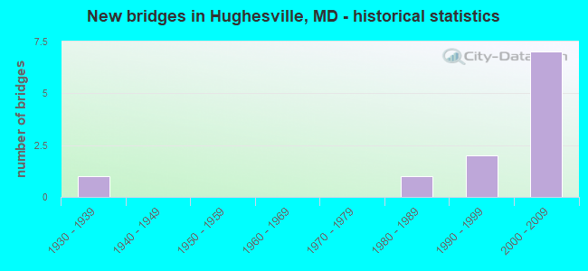
- New bridges - historical statistics
- 11930-1939
- 11980-1989
- 21990-1999
- 72000-2009


- Bridge Condition - Deck
- 75.0%Very good
- 25.0%Good

- Bridge Condition - Superstructure
- 75.0%Very good
- 25.0%Good

- Bridge Condition - Substructure
- 75.0%Very good
- 25.0%Good

- Bridge Condition - Channel
- 60.0%Good
- 20.0%Satisfactory
- 20.0%Fair

- Bridge Condition - Culverts
- 50.0%Good
- 50.0%Poor
Find on map >> Show street view
Structure Number: 10000008000402, Location: 2.94 MI W OF ST MARY'S CO (Lat: 38.483767, Lng: -76.843567), Route carried "on" structure: State highway 6, Year Built: 1987, Status: Open, Structure Length: 1.95m (6.40ft), Average Daily Traffic: 6,492 (year 2009), Truck Traffic: 8%, Average Future Daily Traffic: 7,255 (year 2026), Design Load: HS 20, Features Intersected: GILBERT SWAMP
Minimum Vertical Clearance: 30+ m (98+ ft), Kilometerpoint: 56.144, Lanes on structure: 2, Base Highway Network: Yes, Owner: State Highway Agency, Approaching Roadway Width: 13.4m (44.0ft), Skew: 2 degrees, Material/Design: Concrete, Design/Construction: Culvert, Length of Maximum Span: 4.6m (15.1ft)
Condition: Channel: Satisfactory, Culverts: Good, Operating Rating: 32.7 metric tons, Method Used To Determine Operating Rating: Field evaluation and documented engineering judgment, Inventory Rating: 32.7 metric tons, Method Used To Determine Inventory Rating: Field evaluation and documented engineering judgment, Structural Evaluation: Better than present minimum criteria, Waterway Adequacy: Better than present minimum criteria, Approach Roadway Alignment: Equal to present desirable criteria, Designated Inspection Frequency: Every 24 months, Inspection Date: September 2021
Find on map >> Show street view
Structure Number: 10000008003201, Location: 1.06 MILES WEST OF MD 5 (Lat: 38.528964, Lng: -76.803011), Route carried "on" structure: State highway 231, Year Built: 1930, Year Reconstructed: 1991, Status: Open, Structure Length: 0.73m (2.40ft), Average Daily Traffic: 2,592 (year 2009), Truck Traffic: 8%, Average Future Daily Traffic: 3,830 (year 2026), Design Load: HS 25 or greater, Features Intersected: GILBERT CREEK
Minimum Vertical Clearance: 30+ m (98+ ft), Kilometerpoint: 3.754, Lanes on structure: 2, Owner: State Highway Agency, Approaching Roadway Width: 7.6m (24.9ft), Material/Design: Prestressed concrete, Design/Construction: Slab, Number Of Spans In Main Unit: 1, Length of Maximum Span: 7.3m (24.0ft), Curb-To-Curb Width: 7.6m (24.9ft), Out-to-Out Width: 8.2m (26.9ft)
Condition: Deck: Good, Superstructure: Good, Substructure: Good, Channel: Good, Operating Rating: 69.4 metric tons, Method Used To Determine Operating Rating: Load Factor (LF), Inventory Rating: 41.3 metric tons, Method Used To Determine Inventory Rating: Load Factor (LF), Structural Evaluation: Better than present minimum criteria, Deck Geometry: High priority of replacement, Waterway Adequacy: Superior to present desirable criteria, Approach Roadway Alignment: Equal to present desirable criteria, Length Of Structure Improvement: 0.73m (2.40ft), Designated Inspection Frequency: Every 24 months, Inspection Date: January 2022, Bridge Improvement Cost: $39,000, Roadway Improvement Cost: $4,000, Total Project Cost: $43,000, Deck Structure Type: Concrete Cast-file-Place, Wearing Surface/Protective System: Wearing Surface: Integral Concrete, Deck Protection: Epoxy Coated Reinforcing
Find on map >> Show street view
Structure Number: 100000080052011, Location: 1.85 M N OF ST MARY'S CO (Lat: 38.533900, Lng: -76.778619), Route carried "on" structure: State highway 5, Year Built: 2006, Status: Open, Structure Length: 5.76m (18.90ft), Average Daily Traffic: 17,551 (year 2006), Truck Traffic: 6%, Average Future Daily Traffic: 20,236 (year 2026), Design Load: HS 25 or greater, Features Intersected: MD 231
Minimum Vertical Clearance: 30+ m (98+ ft), Kilometerpoint: 2.949, Lanes on structure: 2, Lanes under structure: 2, Owner: State Highway Agency, Approaching Roadway Width: 12.2m (40.0ft), Skew: 1 degrees, Material/Design: Prestressed concrete continuous, Design/Construction: Stringer/Multi-beam, Number Of Spans In Main Unit: 2, Length of Maximum Span: 29.9m (98.1ft), Curb-To-Curb Width: 11.6m (38.1ft), Out-to-Out Width: 12.8m (42.0ft)
Condition: Deck: Very good, Superstructure: Very good, Substructure: Very good, Operating Rating: 61.7 metric tons, Method Used To Determine Operating Rating: Load Factor (LF), Inventory Rating: 36.7 metric tons, Method Used To Determine Inventory Rating: Load Factor (LF), Structural Evaluation: Equal to present desirable criteria, Deck Geometry: Better than present minimum criteria, Underclear: Somewhat better than minimum adequacy, Approach Roadway Alignment: Equal to present desirable criteria, Designated Inspection Frequency: Every 24 months, Inspection Date: January 2021, Deck Structure Type: Concrete Cast-file-Place, Wearing Surface/Protective System: Wearing Surface: Monolithic Concrete, Deck Protection: Epoxy Coated Reinforcing
Find on map >> Show street view
Structure Number: 100000080052012, Location: 1.85 M N OF ST MARY'S CO (Lat: 38.534269, Lng: -76.779225), Route carried "on" structure: State highway 5, Year Built: 2006, Status: Open, Structure Length: 5.76m (18.90ft), Average Daily Traffic: 17,551 (year 2006), Truck Traffic: 6%, Average Future Daily Traffic: 20,236 (year 2026), Design Load: HS 25 or greater, Features Intersected: MD 231
Minimum Vertical Clearance: 30+ m (98+ ft), Kilometerpoint: 2.949, Lanes on structure: 2, Lanes under structure: 2, Owner: State Highway Agency, Approaching Roadway Width: 12.2m (40.0ft), Skew: 1 degrees, Material/Design: Prestressed concrete continuous, Design/Construction: Stringer/Multi-beam, Number Of Spans In Main Unit: 2, Length of Maximum Span: 29.9m (98.1ft), Curb-To-Curb Width: 11.6m (38.1ft), Out-to-Out Width: 12.8m (42.0ft)
Condition: Deck: Very good, Superstructure: Very good, Substructure: Very good, Operating Rating: 61.7 metric tons, Method Used To Determine Operating Rating: Load Factor (LF), Inventory Rating: 36.7 metric tons, Method Used To Determine Inventory Rating: Load Factor (LF), Structural Evaluation: Equal to present desirable criteria, Deck Geometry: Better than present minimum criteria, Underclear: Somewhat better than minimum adequacy, Approach Roadway Alignment: Equal to present desirable criteria, Designated Inspection Frequency: Every 24 months, Inspection Date: January 2021, Deck Structure Type: Concrete Cast-file-Place, Wearing Surface/Protective System: Wearing Surface: Monolithic Concrete, Deck Protection: Epoxy Coated Reinforcing
Find on map >> Show street view
Structure Number: 10000008005301, Location: AT MD 5 (Lat: 38.526244, Lng: -76.778711), Route carried "on" structure: County highway 99, Year Built: 2006, Status: Open, Structure Length: 6.25m (20.51ft), Average Daily Traffic: 50 (year 2005), Average Future Daily Traffic: 60 (year 2025), Design Load: HS 25 or greater, Features Intersected: MD 5, Facility Carried by Structure: HOMELAND DRIVE
Minimum Vertical Clearance: 30+ m (98+ ft), Kilometerpoint: 0.002, Lanes on structure: 2, Lanes under structure: 4, Owner: State Highway Agency, Approaching Roadway Width: 9.8m (32.2ft), Material/Design: Prestressed concrete continuous, Design/Construction: Stringer/Multi-beam, Number Of Spans In Main Unit: 2, Length of Maximum Span: 30.5m (100.1ft), Curb-To-Curb Width: 11.2m (36.7ft), Out-to-Out Width: 12.4m (40.7ft)
Condition: Deck: Very good, Superstructure: Very good, Substructure: Very good, Operating Rating: 67.6 metric tons, Method Used To Determine Operating Rating: Load Factor (LF), Inventory Rating: 38.5 metric tons, Method Used To Determine Inventory Rating: Load Factor (LF), Structural Evaluation: Equal to present desirable criteria, Deck Geometry: Superior to present desirable criteria, Underclear: Better than present minimum criteria, Approach Roadway Alignment: Equal to present desirable criteria, Designated Inspection Frequency: Every 24 months, Inspection Date: January 2021, Deck Structure Type: Concrete Cast-file-Place, Wearing Surface/Protective System: Wearing Surface: Monolithic Concrete, Deck Protection: Epoxy Coated Reinforcing
Find on map >> Show street view
Structure Number: 200000CH002303, Location: 1 MI E GALLANT GREEN RD (Lat: 38.565833, Lng: -76.769444), Route carried "on" structure: County highway 1474, Year Built: 1992, Status: Open, Structure Length: 1.13m (3.71ft), Average Daily Traffic: 1,100 (year 2002), Truck Traffic: 5%, Average Future Daily Traffic: 1,100 (year 2012), Features Intersected: SWANSON CREEK, Facility Carried by Structure: TRUMAN MANOR LANE
Minimum Vertical Clearance: 30+ m (98+ ft), Kilometerpoint: 0.000, Lanes on structure: 2, Owner: County Highway Agency, Approaching Roadway Width: 7.3m (24.0ft), Skew: 1 degrees, Material/Design: Steel, Design/Construction: Culvert, Length of Maximum Span: 2.7m (8.9ft)
Condition: Channel: Good, Culverts: Poor, Inventory Rating: 55.3 metric tons, Method Used To Determine Inventory Rating: Load Factor (LF), Structural Evaluation: Meets minimum limits, Waterway Adequacy: Better than present minimum criteria, Approach Roadway Alignment: Better than present minimum criteria, Designated Inspection Frequency: Every 24 months, Inspection Date: August 2021
Find on map >> Show street view
Structure Number: 200000CH002403, Location: 1 MI E. GALLANT GREEN RD (Lat: 38.574197, Lng: -76.765814), Route carried "on" structure: County highway 1628, Year Built: 1992, Status: Open, Structure Length: 1.52m (4.99ft), Average Daily Traffic: 1,100 (year 2002), Truck Traffic: 5%, Average Future Daily Traffic: 1,100 (year 2012), Features Intersected: SWANSON CREEK, Facility Carried by Structure: CELESTIAL LANE
Minimum Vertical Clearance: 30+ m (98+ ft), Kilometerpoint: 0.000, Lanes on structure: 2, Owner: County Highway Agency, Approaching Roadway Width: 6.7m (22.0ft), Skew: 3 degrees, Material/Design: Steel, Design/Construction: Culvert, Length of Maximum Span: 3.0m (9.8ft)
Condition: Channel: Fair, Culverts: Poor, Structural Evaluation: Meets minimum limits, Waterway Adequacy: Better than present minimum criteria, Approach Roadway Alignment: Equal to present desirable criteria, Designated Inspection Frequency: Every 24 months, Inspection Date: August 2021
Find on map >> Show street view
Structure Number: 200000CH003604, Location: EAGLE RIDGE SUBDIVISION (Lat: 38.565839, Lng: -76.768539), Route carried "on" structure: County highway , Year Built: 2007, Status: Open, Structure Length: 0.98m (3.22ft), Average Daily Traffic: 2,000 (year 2014), Truck Traffic: 2%, Average Future Daily Traffic: 3,000 (year 2034), Design Load: HS 25 or greater, Features Intersected: SWANSON CREEK, Facility Carried by Structure: BASSFORD ROAD
Minimum Vertical Clearance: 30+ m (98+ ft), Kilometerpoint: 0.000, Lanes on structure: 2, Owner: County Highway Agency, Approaching Roadway Width: 7.3m (24.0ft), Material/Design: Concrete, Design/Construction: Culvert, Length of Maximum Span: 9.8m (32.2ft), Curb or Sidewalk Widths: Left: 0.2m (0.7ft), Right: 0.2m (0.7ft)
Condition: Channel: Good, Culverts: Good, Inventory Rating: 82.1 metric tons, Method Used To Determine Inventory Rating: Load Factor (LF), Structural Evaluation: Better than present minimum criteria, Waterway Adequacy: Equal to present desirable criteria, Approach Roadway Alignment: Equal to present desirable criteria, Designated Inspection Frequency: Every 24 months, Inspection Date: October 2021
Find on map >> Show street view
Structure Number: 100000080052011, Location: 1.83 MILES WEST OF MD 381 (Lat: 38.533900, Lng: -76.778619), Route carried "under" structure: State highway 231, Year Built: 2006, Structure Length: 0. m, Average Daily Traffic: 3,322 (year 2006), Truck Traffic: 8%, Features Intersected: MD 231, Facility Carried by Structure: MD 5 NBR
Minimum Vertical Clearance: 5.49m (18.01ft), Kilometerpoint: 5.971, Lanes on structure: 2, Lanes under structure: 4, Material/Design: Prestressed concrete continuous, Design/Construction: Stringer/Multi-beam, Length of Maximum Span: 29.9m (98.1ft)
Find on map >> Show street view
Structure Number: 100000080052012, Location: 1.14 MILES WEST OF MD 381 (Lat: 38.534269, Lng: -76.779225), Route carried "under" structure: State highway 231, Year Built: 2006, Structure Length: 0. m, Average Daily Traffic: 3,322 (year 2006), Truck Traffic: 8%, Features Intersected: MD 231, Facility Carried by Structure: MD 5 SBR
Minimum Vertical Clearance: 5.18m (16.99ft), Kilometerpoint: 5.471, Lanes on structure: 2, Lanes under structure: 4, Material/Design: Prestressed concrete continuous, Design/Construction: Stringer/Multi-beam, Length of Maximum Span: 29.9m (98.1ft)
Find on map >> Show street view
Structure Number: 10000008005301, Location: 1.244 M N OF ST MARY'S CO (Lat: 38.526244, Lng: -76.778711), Route carried "under" structure: State highway 5, Year Built: 2006, Structure Length: 0. m, Average Daily Traffic: 37,850 (year 2009), Truck Traffic: 6%, Features Intersected: MD 5, Facility Carried by Structure: HOMELAND DRIVE
Minimum Vertical Clearance: 4.88m (16.01ft), Kilometerpoint: 2.002, Lanes on structure: 2, Lanes under structure: 4, Material/Design: Prestressed concrete continuous, Design/Construction: Stringer/Multi-beam, Length of Maximum Span: 30.5m (100.1ft)