Bridge Statistics for Hudson, Michigan (MI)
Condition, Traffic, Stress, Structural Evaluation, Project Costs
- National Bridge Inventory (NBI) Statistics
- 20Number of bridges
- 128ft / 39.0mTotal length
- $441,000Total costs
- 29,322Total average daily traffic
- 2,135Total average daily truck traffic
- 40,572Total future (year 1977) average daily traffic
- National Bridge Inventory (NBI) Registered Bridges for Hudson
- No street view available for this location
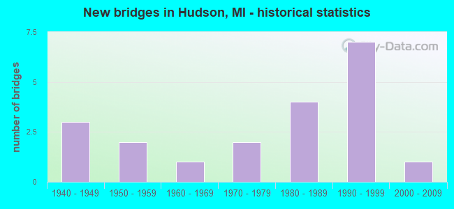
- New bridges - historical statistics
- 31940-1949
- 21950-1959
- 11960-1969
- 21970-1979
- 41980-1989
- 71990-1999
- 12000-2009

- Reconstructed bridges - Historical Statistics
- 11990-1999
- 32000-2009


- Bridge Condition - Deck
- 33.3%Very good
- 27.8%Good
- 16.7%Satisfactory
- 22.2%Fair

- Bridge Condition - Superstructure
- 33.3%Very good
- 27.8%Good
- 16.7%Satisfactory
- 22.2%Fair

- Bridge Condition - Substructure
- 22.2%Very good
- 33.3%Good
- 27.8%Satisfactory
- 11.1%Fair
- 5.6%Critical

- Bridge Condition - Channel
- 15.0%Very good
- 20.0%Good
- 35.0%Satisfactory
- 25.0%Fair
- 5.0%Poor

- Bridge Condition - Culverts
- 50.0%Very good
- 50.0%Satisfactory
Find on map >> Show street view
Structure Number: 435, Location: 0.3 MILE EAST OF SANTIAGO (Lat: 44.113356, Lng: -83.700456), Route carried "on" structure: County highway 680, Year Built: 1986, Status: Open, Structure Length: 2.56m (8.40ft), Average Daily Traffic: 423 (year 2018), Average Future Daily Traffic: 600 (year 2038), Design Load: HS 20+Mod, Features Intersected: AUGRES RIVER, Facility Carried by Structure: TWINING ROAD
Minimum Vertical Clearance: 30.48m (100.00ft), Kilometerpoint: 27.149, Lanes on structure: 2, Owner: County Highway Agency, Approaching Roadway Width: 7.9m (25.9ft), Material/Design: Prestressed concrete, Design/Construction: Box Beam or Girders - Multiple, Number Of Spans In Main Unit: 3, Length of Maximum Span: 12.2m (40.0ft), Curb-To-Curb Width: 10.4m (34.1ft), Out-to-Out Width: 11.3m (37.1ft)
Condition: Deck: Satisfactory, Superstructure: Satisfactory, Substructure: Satisfactory, Channel: Fair, Operating Rating: 50.9 metric tons, Method Used To Determine Operating Rating: Load Factor (LF) rating reported by rating factor (RF) method using MS18 loading, Inventory Rating: 30.5 metric tons, Method Used To Determine Inventory Rating: Load Factor (LF) rating reported by rating factor (RF) method using MS18 loading, Structural Evaluation: Equal to present minimum criteria, Deck Geometry: Equal to present minimum criteria, Waterway Adequacy: Better than present minimum criteria, Approach Roadway Alignment: Better than present minimum criteria, Designated Inspection Frequency: Every 24 months, Inspection Date: August 2020, Deck Structure Type: Concrete Cast-file-Place, Wearing Surface/Protective System: Wearing Surface: Bituminous, Membrane: Preformed Fabric, Deck Protection: Epoxy Coated Reinforcing
Find on map >> Show street view
Structure Number: 439, Location: 4 MILES EAST OF TURNER (Lat: 44.142600, Lng: -83.706061), Route carried "on" structure: County highway 690, Year Built: 1959, Status: Open, Structure Length: 2.31m (7.58ft), Average Daily Traffic: 963 (year 1998), Average Future Daily Traffic: 310 (year 1977), Design Load: HS 20+Mod, Features Intersected: AUGRES RIVER, Facility Carried by Structure: TURNER ROAD
Minimum Vertical Clearance: 30.48m (100.00ft), Kilometerpoint: 34.741, Lanes on structure: 2, Owner: County Highway Agency, Approaching Roadway Width: 9.4m (30.8ft), Material/Design: Prestressed concrete, Design/Construction: Box Beam or Girders - Multiple, Number Of Spans In Main Unit: 2, Length of Maximum Span: 10.6m (34.8ft), Curb or Sidewalk Widths: Left: 0.4m (1.3ft), Right: 0.4m (1.3ft), Curb-To-Curb Width: 7.3m (24.0ft), Out-to-Out Width: 8.6m (28.2ft)
Condition: Deck: Fair, Superstructure: Satisfactory, Substructure: Satisfactory, Channel: Good, Operating Rating: 69.0 metric tons, Method Used To Determine Operating Rating: Load Factor (LF) rating reported by rating factor (RF) method using MS18 loading, Inventory Rating: 40.2 metric tons, Method Used To Determine Inventory Rating: Load Factor (LF) rating reported by rating factor (RF) method using MS18 loading, Structural Evaluation: Equal to present minimum criteria, Deck Geometry: Meets minimum limits, Waterway Adequacy: Better than present minimum criteria, Approach Roadway Alignment: Equal to present minimum criteria, Designated Inspection Frequency: Every 24 months, Inspection Date: August 2020, Bridge Improvement Cost: $6,000, Roadway Improvement Cost: $1,000, Total Project Cost: $7,000, Deck Structure Type: Concrete Cast-file-Place, Wearing Surface/Protective System: Wearing Surface: Bituminous
Find on map >> Show street view
Structure Number: 3273, Location: 2.4 MI SW OF HUDSON (Lat: 41.825533, Lng: -84.361369), Route carried "on" structure: US 127, Year Built: 1947, Year Reconstructed: 2007, Status: Open, Structure Length: 3.66m (12.01ft), Average Daily Traffic: 5,136 (year 2007), Truck Traffic: 11%, Average Future Daily Traffic: 5,636 (year 2018), Design Load: HS 20, Features Intersected: BEAN CREEK
Minimum Vertical Clearance: 30.48m (100.00ft), Kilometerpoint: 13.207, Lanes on structure: 2, Base Highway Network: Yes (Inventory Route: 52, Subroute: 4), Owner: State Highway Agency, Approaching Roadway Width: 11.6m (38.1ft), Material/Design: Steel continuous, Design/Construction: Stringer/Multi-beam, Number Of Spans In Main Unit: 3, Length of Maximum Span: 15.2m (49.9ft), Curb-To-Curb Width: 12.1m (39.7ft), Out-to-Out Width: 13.3m (43.6ft)
Condition: Deck: Fair, Superstructure: Satisfactory, Substructure: Satisfactory, Channel: Fair, Operating Rating: 66.7 metric tons, Method Used To Determine Operating Rating: Load Factor (LF) rating reported by rating factor (RF) method using MS18 loading, Inventory Rating: 39.9 metric tons, Method Used To Determine Inventory Rating: Load Factor (LF) rating reported by rating factor (RF) method using MS18 loading, Structural Evaluation: Equal to present minimum criteria, Deck Geometry: Somewhat better than minimum adequacy, Waterway Adequacy: Equal to present minimum criteria, Approach Roadway Alignment: Equal to present desirable criteria, Designated Inspection Frequency: Every 24 months, Inspection Date: May 2020, Deck Structure Type: Concrete Cast-file-Place, Wearing Surface/Protective System: Wearing Surface: Latex Concrete
Find on map >> Show street view
Structure Number: 3274, Location: 1.7 MI SW OF HUDSON (Lat: 41.836653, Lng: -84.361625), Route carried "on" structure: US 127, Year Built: 1947, Year Reconstructed: 2007, Status: Open, Structure Length: 3.44m (11.29ft), Average Daily Traffic: 5,136 (year 2007), Truck Traffic: 11%, Average Future Daily Traffic: 5,636 (year 2018), Design Load: HS 20, Features Intersected: BEAN CREEK
Minimum Vertical Clearance: 30.48m (100.00ft), Kilometerpoint: 14.441, Lanes on structure: 2, Base Highway Network: Yes (Inventory Route: 52, Subroute: 4), Owner: State Highway Agency, Approaching Roadway Width: 11.6m (38.1ft), Material/Design: Steel, Design/Construction: Stringer/Multi-beam, Number Of Spans In Main Unit: 3, Length of Maximum Span: 14.9m (48.9ft), Curb-To-Curb Width: 12.1m (39.7ft), Out-to-Out Width: 13.3m (43.6ft)
Condition: Deck: Fair, Superstructure: Fair, Substructure: Satisfactory, Channel: Fair, Operating Rating: 61.6 metric tons, Method Used To Determine Operating Rating: Load Factor (LF) rating reported by rating factor (RF) method using MS18 loading, Inventory Rating: 36.9 metric tons, Method Used To Determine Inventory Rating: Load Factor (LF) rating reported by rating factor (RF) method using MS18 loading, Structural Evaluation: Somewhat better than minimum adequacy, Deck Geometry: Somewhat better than minimum adequacy, Waterway Adequacy: Equal to present minimum criteria, Approach Roadway Alignment: Equal to present desirable criteria, Length Of Structure Improvement: 3.45m (11.32ft), Designated Inspection Frequency: Every 24 months, Inspection Date: May 2020, Bridge Improvement Cost: $71,000, Roadway Improvement Cost: $5,000, Total Project Cost: $60,000, Deck Structure Type: Concrete Cast-file-Place, Wearing Surface/Protective System: Wearing Surface: Latex Concrete
Find on map >> Show street view
Structure Number: 3275, Location: 2.5 MI NW OF HUDSON (Lat: 41.885169, Lng: -84.363864), Route carried "on" structure: US 127, Year Built: 1991, Status: Open, Structure Length: 0.94m (3.08ft), Average Daily Traffic: 5,142 (year 2007), Truck Traffic: 11%, Average Future Daily Traffic: 5,925 (year 2018), Design Load: HS 20, Features Intersected: BEECHER CREEK
Minimum Vertical Clearance: 30.48m (100.00ft), Kilometerpoint: 19.860, Lanes on structure: 2, Base Highway Network: Yes (Inventory Route: 52, Subroute: 4), Owner: State Highway Agency, Approaching Roadway Width: 13.4m (44.0ft), Material/Design: Prestressed concrete, Design/Construction: Stringer/Multi-beam, Number Of Spans In Main Unit: 1, Length of Maximum Span: 9.4m (30.8ft), Curb-To-Curb Width: 14.6m (47.9ft), Out-to-Out Width: 15.6m (51.2ft)
Condition: Deck: Good, Superstructure: Good, Substructure: Satisfactory, Channel: Satisfactory, Operating Rating: 65.1 metric tons, Method Used To Determine Operating Rating: Load Factor (LF) rating reported by rating factor (RF) method using MS18 loading, Inventory Rating: 38.9 metric tons, Method Used To Determine Inventory Rating: Load Factor (LF) rating reported by rating factor (RF) method using MS18 loading, Structural Evaluation: Equal to present minimum criteria, Deck Geometry: Superior to present desirable criteria, Waterway Adequacy: Equal to present minimum criteria, Approach Roadway Alignment: Equal to present desirable criteria, Designated Inspection Frequency: Every 24 months, Inspection Date: May 2020, Deck Structure Type: Concrete Cast-file-Place, Wearing Surface/Protective System: Wearing Surface: Monolithic Concrete, Deck Protection: Epoxy Coated Reinforcing
Find on map >> Show street view
Structure Number: 3298, Location: 0.8 MILE E OF GARDNER RD (Lat: 41.883828, Lng: -84.384836), Route carried "on" structure: Alternate County highway 3046, Year Built: 1992, Status: Open, Structure Length: 1.22m (4.00ft), Average Daily Traffic: 742 (year 2013), Average Future Daily Traffic: 1,217 (year 2038), Design Load: HS 20, Features Intersected: ST JOSEPH CREEK, Facility Carried by Structure: BEECHER ROAD
Minimum Vertical Clearance: 30.48m (100.00ft), Kilometerpoint: 7.614, Lanes on structure: 2, Owner: County Highway Agency, Approaching Roadway Width: 9.8m (32.2ft), Skew: 3 degrees, Material/Design: Prestressed concrete, Design/Construction: Box Beam or Girders - Multiple, Number Of Spans In Main Unit: 1, Length of Maximum Span: 10.9m (35.8ft), Curb-To-Curb Width: 10.4m (34.1ft), Out-to-Out Width: 10.5m (34.4ft)
Condition: Deck: Satisfactory, Superstructure: Fair, Substructure: Very good, Channel: Very good, Operating Rating: 43.8 metric tons, Method Used To Determine Operating Rating: Load Factor (LF), Inventory Rating: 26.2 metric tons, Method Used To Determine Inventory Rating: Load Factor (LF), Structural Evaluation: Somewhat better than minimum adequacy, Deck Geometry: Equal to present minimum criteria, Waterway Adequacy: Equal to present desirable criteria, Approach Roadway Alignment: Equal to present desirable criteria, Designated Inspection Frequency: Every 24 months, Inspection Date: November 2020, Deck Structure Type: Concrete Precast Panels, Wearing Surface/Protective System: Wearing Surface: Bituminous, Membrane: Built-up
Find on map >> Show street view
Structure Number: 3345, Location: 0.2 MILE WEST OF US-127 (Lat: 41.895817, Lng: -84.371211), Route carried "on" structure: County highway , Year Built: 1981, Status: Open, Structure Length: 0.82m (2.69ft), Average Daily Traffic: 85 (year 2014), Average Future Daily Traffic: 139 (year 2038), Design Load: HS 20, Features Intersected: ST JOSEPH CREEK, Facility Carried by Structure: BRYANT ROAD
Minimum Vertical Clearance: 30.48m (100.00ft), Kilometerpoint: 0.808, Lanes on structure: 2, Owner: County Highway Agency, Approaching Roadway Width: 9.1m (29.9ft), Material/Design: Steel, Design/Construction: Culvert, Number Of Spans In Main Unit: 3, Length of Maximum Span: 2.4m (7.9ft), Curb-To-Curb Width: 6.1m (20.0ft), Out-to-Out Width: 10.4m (34.1ft)
Condition: Channel: Satisfactory, Culverts: Satisfactory, Operating Rating: 68.0 metric tons, Method Used To Determine Operating Rating: Load Factor (LF) rating reported by rating factor (RF) method using MS18 loading, Inventory Rating: 40.8 metric tons, Method Used To Determine Inventory Rating: Load Factor (LF) rating reported by rating factor (RF) method using MS18 loading, Structural Evaluation: Equal to present minimum criteria, Deck Geometry: Somewhat better than minimum adequacy, Waterway Adequacy: Equal to present desirable criteria, Approach Roadway Alignment: Equal to present minimum criteria, Designated Inspection Frequency: Every 24 months, Inspection Date: November 2020
Find on map >> Show street view
Structure Number: 4063, Location: 0.5 MI N 1.5 MI W OFIONIA (Lat: 43.001867, Lng: -85.119625), Route carried "on" structure: ServiceCounty highway , Year Built: 2005, Status: Open, Structure Length: 1.74m (5.71ft), Average Daily Traffic: 107 (year 2008), Truck Traffic: 8%, Average Future Daily Traffic: 124 (year 2028), Design Load: HS 20+Mod, Features Intersected: BELLAMY CREEK, Facility Carried by Structure: LYLE ROAD
Minimum Vertical Clearance: 30.48m (100.00ft), Kilometerpoint: 1.194, Lanes on structure: 2, Owner: County Highway Agency, Approaching Roadway Width: 9.1m (29.9ft), Skew: 1 degrees, Material/Design: Prestressed concrete, Design/Construction: Box Beam or Girders - Single/Spread, Number Of Spans In Main Unit: 1, Length of Maximum Span: 17.0m (55.8ft), Curb-To-Curb Width: 9.1m (29.9ft), Out-to-Out Width: 10.0m (32.8ft)
Condition: Deck: Very good, Superstructure: Very good, Substructure: Good, Channel: Good, Operating Rating: 97.2 metric tons, Method Used To Determine Operating Rating: Load Factor (LF) rating reported by rating factor (RF) method using MS18 loading, Inventory Rating: 67.4 metric tons, Method Used To Determine Inventory Rating: Load Factor (LF) rating reported by rating factor (RF) method using MS18 loading, Structural Evaluation: Better than present minimum criteria, Deck Geometry: Equal to present minimum criteria, Waterway Adequacy: Equal to present minimum criteria, Approach Roadway Alignment: Equal to present minimum criteria, Designated Inspection Frequency: Every 24 months, Inspection Date: October 2020, Deck Structure Type: Concrete Cast-file-Place, Wearing Surface/Protective System: Wearing Surface: Integral Concrete, Deck Protection: Epoxy Coated Reinforcing
Find on map >> Show street view
Structure Number: 437, Location: SEC 20-21 SHERMAN TWP (Lat: 43.682953, Lng: -85.047883), Route carried "on" structure: ServiceCounty highway , Year Built: 1941, Status: Posted for load, Structure Length: 1.64m (5.38ft), Average Daily Traffic: 233 (year 2004), Average Future Daily Traffic: 333 (year 2024), Design Load: H 15, Features Intersected: SOUTH BR CHIPPEWA RIVER, Facility Carried by Structure: WYMAN ROAD
Minimum Vertical Clearance: 30.48m (100.00ft), Kilometerpoint: 6.487, Lanes on structure: 2, Owner: County Highway Agency, Approaching Roadway Width: 8.5m (27.9ft), Material/Design: Steel, Design/Construction: Stringer/Multi-beam, Number Of Spans In Main Unit: 1, Length of Maximum Span: 15.2m (49.9ft), Curb-To-Curb Width: 7.3m (24.0ft), Out-to-Out Width: 7.9m (25.9ft)
Condition: Deck: Fair, Superstructure: Fair, Substructure: Fair, Channel: Fair, Operating Rating: 38.1 metric tons, Method Used To Determine Operating Rating: Load Factor (LF), Inventory Rating: 22.8 metric tons, Method Used To Determine Inventory Rating: Load Factor (LF), Structural Evaluation: Somewhat better than minimum adequacy, Deck Geometry: Somewhat better than minimum adequacy, Waterway Adequacy: Somewhat better than minimum adequacy, Approach Roadway Alignment: Somewhat better than minimum adequacy, Bridge Posting: Required (Relationship of Operating Rating to Maximum Legal Load: 20.0 - 29.9% below), Length Of Structure Improvement: 2.44m (8.01ft), Designated Inspection Frequency: Every 24 months, Inspection Date: May 2020, Bridge Improvement Cost: $324,000, Roadway Improvement Cost: $50,000, Total Project Cost: $374,000, Deck Structure Type: Concrete Cast-file-Place, Wearing Surface/Protective System: Wearing Surface: Bituminous
Find on map >> Show street view
Structure Number: 4505, Location: IN NORVELL (Lat: 42.156600, Lng: -84.184050), Route carried "on" structure: County highway , Year Built: 1985, Status: Posted for load, Structure Length: 1.28m (4.20ft), Average Daily Traffic: 550 (year 2002), Average Future Daily Traffic: 650 (year 2022), Design Load: HS 20+Mod, Features Intersected: RAISIN RIVER, Facility Carried by Structure: MILL STREET
Minimum Vertical Clearance: 30.48m (100.00ft), Kilometerpoint: 0.097, Lanes on structure: 2, Owner: County Highway Agency, Approaching Roadway Width: 10.4m (34.1ft), Material/Design: Prestressed concrete, Design/Construction: Box Beam or Girders - Multiple, Number Of Spans In Main Unit: 1, Length of Maximum Span: 12.8m (42.0ft), Curb-To-Curb Width: 10.4m (34.1ft), Out-to-Out Width: 10.4m (34.1ft)
Condition: Deck: Satisfactory, Superstructure: Fair, Substructure: Good, Channel: Good, Operating Rating: 29.8 metric tons, Method Used To Determine Operating Rating: Load Factor (LF) rating reported by rating factor (RF) method using MS18 loading, Inventory Rating: 17.8 metric tons, Method Used To Determine Inventory Rating: Load Factor (LF) rating reported by rating factor (RF) method using MS18 loading, Structural Evaluation: Meets minimum limits, Deck Geometry: Equal to present minimum criteria, Waterway Adequacy: Equal to present desirable criteria, Approach Roadway Alignment: Better than present minimum criteria, Bridge Posting: Required (Relationship of Operating Rating to Maximum Legal Load: 10.0 - 19.9% below), Designated Inspection Frequency: Every 24 months, Inspection Date: June 2021, Deck Structure Type: Concrete Cast-file-Place, Wearing Surface/Protective System: Wearing Surface: Bituminous, Membrane: Preformed Fabric, Deck Protection: Epoxy Coated Reinforcing
Find on map >> Show street view
Structure Number: 5505, Location: IN HUDSON (Lat: 41.854961, Lng: -84.351189), Route carried "on" structure: State highway 34, Year Built: 1998, Status: Open, Structure Length: 2.02m (6.63ft), Average Daily Traffic: 6,285 (year 2007), Truck Traffic: 5%, Average Future Daily Traffic: 9,427 (year 2018), Design Load: HS 25 or greater, Features Intersected: BEAN CREEK
Minimum Vertical Clearance: 30.48m (100.00ft), Kilometerpoint: 0.887, Lanes on structure: 2, Owner: State Highway Agency, Approaching Roadway Width: 9.1m (29.9ft), Skew: 1 degrees, Material/Design: Prestressed concrete, Design/Construction: Box Beam or Girders - Single/Spread, Number Of Spans In Main Unit: 1, Length of Maximum Span: 20.2m (66.3ft), Curb or Sidewalk Widths: Left: 2.2m (7.2ft), Right: 2.2m (7.2ft), Curb-To-Curb Width: 9.1m (29.9ft), Out-to-Out Width: 13.2m (43.3ft)
Condition: Deck: Good, Superstructure: Very good, Substructure: Good, Channel: Satisfactory, Operating Rating: 97.2 metric tons, Method Used To Determine Operating Rating: Load Factor (LF) rating reported by rating factor (RF) method using MS18 loading, Inventory Rating: 42.1 metric tons, Method Used To Determine Inventory Rating: Load Factor (LF) rating reported by rating factor (RF) method using MS18 loading, Structural Evaluation: Better than present minimum criteria, Deck Geometry: High priority of corrective action, Waterway Adequacy: Equal to present desirable criteria, Approach Roadway Alignment: Equal to present desirable criteria, Designated Inspection Frequency: Every 24 months, Inspection Date: June 2020, Deck Structure Type: Concrete Cast-file-Place, Wearing Surface/Protective System: Wearing Surface: Monolithic Concrete, Deck Protection: Epoxy Coated Reinforcing
Find on map >> Show street view
Structure Number: 5559, Location: 0.25 MI W OF LAWRENCE RD (Lat: 41.812983, Lng: -84.278803), Route carried "on" structure: County highway 4626, Year Built: 1950, Year Reconstructed: 2003, Status: Open, Structure Length: 3.65m (11.98ft), Average Daily Traffic: 318 (year 2012), Truck Traffic: 3%, Average Future Daily Traffic: 700 (year 2031), Design Load: HS 20, Features Intersected: BEAN CREEK, Facility Carried by Structure: MEDINA RD
Minimum Vertical Clearance: 30.48m (100.00ft), Kilometerpoint: 6.877, Lanes on structure: 2, Owner: County Highway Agency, Approaching Roadway Width: 9.1m (29.9ft), Skew: 3 degrees, Material/Design: Wood or Timber, Design/Construction: Slab, Number Of Spans In Main Unit: 3, Length of Maximum Span: 18.2m (59.7ft), Curb or Sidewalk Widths: Left: 0.4m (1.3ft), Right: 0.4m (1.3ft), Curb-To-Curb Width: 8.5m (27.9ft), Out-to-Out Width: 9.0m (29.5ft)
Condition: Deck: Very good, Superstructure: Very good, Substructure: Fair, Channel: Good, Operating Rating: 53.8 metric tons, Method Used To Determine Operating Rating: Allowable Stress (AS) rating reported by rating factor (RF) method using MS18 loading, Inventory Rating: 37.9 metric tons, Method Used To Determine Inventory Rating: Allowable Stress (AS) rating reported by rating factor (RF) method using MS18 loading, Structural Evaluation: Somewhat better than minimum adequacy, Deck Geometry: Equal to present minimum criteria, Waterway Adequacy: Equal to present desirable criteria, Approach Roadway Alignment: Equal to present minimum criteria, Designated Inspection Frequency: Every 24 months, Inspection Date: November 2020, Deck Structure Type: Concrete Cast-file-Place, Wearing Surface/Protective System: Wearing Surface: Bituminous
Find on map >> Show street view
Structure Number: 5563, Location: EAST OF DILLON HWY (Lat: 41.834842, Lng: -84.314158), Route carried "on" structure: County highway , Year Built: 1993, Status: Open, Structure Length: 0.79m (2.59ft), Average Daily Traffic: 243 (year 2012), Truck Traffic: 2%, Average Future Daily Traffic: 575 (year 2031), Design Load: HS 20, Features Intersected: BEAN CREEK, Facility Carried by Structure: LAWRENCE RD
Minimum Vertical Clearance: 30.48m (100.00ft), Kilometerpoint: 1.650, Lanes on structure: 2, Owner: County Highway Agency, Approaching Roadway Width: 9.1m (29.9ft), Material/Design: Concrete, Design/Construction: Culvert, Number Of Spans In Main Unit: 1, Length of Maximum Span: 7.3m (24.0ft), Curb-To-Curb Width: 9.1m (29.9ft), Out-to-Out Width: 9.1m (29.9ft)
Condition: Channel: Very good, Culverts: Very good, Operating Rating: 54.5 metric tons, Method Used To Determine Operating Rating: Field evaluation and documented engineering judgment, Inventory Rating: 32.7 metric tons, Method Used To Determine Inventory Rating: Field evaluation and documented engineering judgment, Structural Evaluation: Equal to present desirable criteria, Deck Geometry: Equal to present minimum criteria, Waterway Adequacy: Equal to present minimum criteria, Approach Roadway Alignment: Equal to present desirable criteria, Designated Inspection Frequency: Every 24 months, Inspection Date: August 2020, Deck Structure Type: Concrete Cast-file-Place, Wearing Surface/Protective System: Wearing Surface: Bituminous
Find on map >> Show street view
Structure Number: 5567, Location: 0.1 MI EAST OF US-127 (Lat: 41.883608, Lng: -84.359992), Route carried "on" structure: County highway 4646, Year Built: 1992, Status: Open, Structure Length: 1.52m (4.99ft), Average Daily Traffic: 1,234 (year 2012), Truck Traffic: 1%, Average Future Daily Traffic: 3,700 (year 2031), Design Load: HS 20, Features Intersected: SILVER CREEK, Facility Carried by Structure: BEECHER RD
Minimum Vertical Clearance: 30.48m (100.00ft), Kilometerpoint: 0.171, Lanes on structure: 2, Owner: County Highway Agency, Approaching Roadway Width: 10.1m (33.1ft), Skew: 3 degrees, Material/Design: Wood or Timber, Design/Construction: Slab, Number Of Spans In Main Unit: 3, Length of Maximum Span: 7.3m (24.0ft), Curb-To-Curb Width: 9.8m (32.2ft), Out-to-Out Width: 10.0m (32.8ft)
Condition: Deck: Very good, Superstructure: Very good, Substructure: Very good, Channel: Satisfactory, Operating Rating: 53.5 metric tons, Method Used To Determine Operating Rating: Allowable Stress (AS), Inventory Rating: 38.3 metric tons, Method Used To Determine Inventory Rating: Allowable Stress (AS), Structural Evaluation: Equal to present desirable criteria, Deck Geometry: Somewhat better than minimum adequacy, Waterway Adequacy: Equal to present minimum criteria, Approach Roadway Alignment: Equal to present minimum criteria, Designated Inspection Frequency: Every 24 months, Inspection Date: November 2020, Deck Structure Type: Wood or Timber, Wearing Surface/Protective System: Wearing Surface: Bituminous
Find on map >> Show street view
Structure Number: 5568, Location: 0.25 MI EAST OF KEIL HWY (Lat: 41.883650, Lng: -84.351431), Route carried "on" structure: County highway 4646, Year Built: 1967, Year Reconstructed: 2000, Status: Open, Structure Length: 1.22m (4.00ft), Average Daily Traffic: 1,234 (year 2012), Truck Traffic: 5%, Average Future Daily Traffic: 3,500 (year 2031), Design Load: H 20, Features Intersected: FITTS CREEK, Facility Carried by Structure: BEECHER RD
Minimum Vertical Clearance: 30.48m (100.00ft), Kilometerpoint: 0.885, Lanes on structure: 2, Owner: County Highway Agency, Approaching Roadway Width: 8.5m (27.9ft), Material/Design: Wood or Timber, Design/Construction: Slab, Number Of Spans In Main Unit: 1, Length of Maximum Span: 11.6m (38.1ft), Curb-To-Curb Width: 9.1m (29.9ft), Out-to-Out Width: 9.5m (31.2ft)
Condition: Deck: Very good, Superstructure: Very good, Substructure: Good, Channel: Satisfactory, Operating Rating: 53.4 metric tons, Method Used To Determine Operating Rating: Allowable Stress (AS), Inventory Rating: 36.6 metric tons, Method Used To Determine Inventory Rating: Allowable Stress (AS), Structural Evaluation: Better than present minimum criteria, Deck Geometry: Somewhat better than minimum adequacy, Waterway Adequacy: Equal to present desirable criteria, Approach Roadway Alignment: Somewhat better than minimum adequacy, Designated Inspection Frequency: Every 24 months, Inspection Date: November 2020, Deck Structure Type: Wood or Timber, Wearing Surface/Protective System: Wearing Surface: Bituminous
Find on map >> Show street view
Structure Number: 5648, Location: 0.1 MI E OF CRAMER HWY (Lat: 41.840931, Lng: -84.348886), Route carried "on" structure: County highway , Year Built: 1990, Status: Open, Structure Length: 1.89m (6.20ft), Average Daily Traffic: 185 (year 2012), Truck Traffic: 1%, Average Future Daily Traffic: 300 (year 2031), Design Load: HS 20, Features Intersected: BEAN CREEK, Facility Carried by Structure: NELSON RD
Minimum Vertical Clearance: 30.48m (100.00ft), Kilometerpoint: 0.480, Lanes on structure: 2, Owner: County Highway Agency, Approaching Roadway Width: 6.1m (20.0ft), Material/Design: Wood or Timber, Design/Construction: Slab, Number Of Spans In Main Unit: 3, Length of Maximum Span: 7.9m (25.9ft), Curb-To-Curb Width: 7.3m (24.0ft), Out-to-Out Width: 7.7m (25.3ft)
Condition: Deck: Good, Superstructure: Good, Substructure: Good, Channel: Satisfactory, Operating Rating: 44.6 metric tons, Method Used To Determine Operating Rating: Allowable Stress (AS), Inventory Rating: 31.5 metric tons, Method Used To Determine Inventory Rating: Allowable Stress (AS), Structural Evaluation: Better than present minimum criteria, Deck Geometry: Somewhat better than minimum adequacy, Waterway Adequacy: Somewhat better than minimum adequacy, Approach Roadway Alignment: Somewhat better than minimum adequacy, Designated Inspection Frequency: Every 24 months, Inspection Date: November 2020, Deck Structure Type: Wood or Timber, Wearing Surface/Protective System: Wearing Surface: Bituminous, Deck Protection: Other
Find on map >> Show street view
Structure Number: 5649, Location: 0.3 MI N OF MEDINA RD (Lat: 41.815725, Lng: -84.332192), Route carried "on" structure: County highway , Year Built: 1996, Status: Open, Structure Length: 2.92m (9.58ft), Average Daily Traffic: 113 (year 2012), Truck Traffic: 1%, Average Future Daily Traffic: 300 (year 2031), Design Load: HS 20, Features Intersected: BEAN CREEK, Facility Carried by Structure: MUNSON HWY
Minimum Vertical Clearance: 30.48m (100.00ft), Kilometerpoint: 11.140, Lanes on structure: 2, Owner: County Highway Agency, Approaching Roadway Width: 8.5m (27.9ft), Material/Design: Prestressed concrete, Design/Construction: Box Beam or Girders - Multiple, Number Of Spans In Main Unit: 1, Length of Maximum Span: 28.0m (91.9ft), Curb-To-Curb Width: 8.5m (27.9ft), Out-to-Out Width: 9.4m (30.8ft)
Condition: Deck: Good, Superstructure: Good, Substructure: Very good, Channel: Very good, Operating Rating: 37.7 metric tons, Method Used To Determine Operating Rating: Load Factor (LF), Inventory Rating: 22.6 metric tons, Method Used To Determine Inventory Rating: Load Factor (LF), Structural Evaluation: Equal to present minimum criteria, Waterway Adequacy: Equal to present desirable criteria, Approach Roadway Alignment: Equal to present desirable criteria, Designated Inspection Frequency: Every 24 months, Inspection Date: August 2020, Deck Structure Type: Concrete Cast-file-Place, Wearing Surface/Protective System: Wearing Surface: Monolithic Concrete, Deck Protection: Epoxy Coated Reinforcing
Find on map >> Show street view
Structure Number: 565, Location: 0.2 MI S OF LAWRENCE RD (Lat: 41.830783, Lng: -84.313325), Route carried "on" structure: County highway , Year Built: 1980, Status: Closed, Structure Length: 1.82m (5.97ft), Average Daily Traffic: 93 (year 2006), Truck Traffic: 1%, Average Future Daily Traffic: 150 (year 2025), Design Load: HS 20, Features Intersected: BEAN CREEK, Facility Carried by Structure: DILLON HWY
Minimum Vertical Clearance: 30.48m (100.00ft), Kilometerpoint: 5.562, Lanes on structure: 2, Owner: County Highway Agency, Approaching Roadway Width: 7.0m (23.0ft), Material/Design: Wood or Timber, Design/Construction: Slab, Number Of Spans In Main Unit: 2, Length of Maximum Span: 9.1m (29.9ft), Curb-To-Curb Width: 6.7m (22.0ft), Out-to-Out Width: 6.8m (22.3ft)
Condition: Deck: Good, Superstructure: Good, Substructure: Critical, Channel: Poor, Operating Rating: 50.0 metric tons, Method Used To Determine Operating Rating: Allowable Stress (AS), Inventory Rating: 34.9 metric tons, Method Used To Determine Inventory Rating: Allowable Stress (AS), Structural Evaluation: High priority of replacement, Deck Geometry: Somewhat better than minimum adequacy, Waterway Adequacy: Equal to present desirable criteria, Approach Roadway Alignment: Somewhat better than minimum adequacy, Designated Inspection Frequency: Every 24 months, Inspection Date: August 2020, Deck Structure Type: Wood or Timber, Wearing Surface/Protective System: Wearing Surface: Bituminous
Find on map >> Show street view
Structure Number: 5721, Location: 645' E OF MARKET ST (Lat: 41.853231, Lng: -84.350086), Route carried "on" structure: Business City street , Year Built: 1977, Status: Open, Structure Length: 1.77m (5.81ft), Average Daily Traffic: 570 (year 2015), Truck Traffic: 3%, Average Future Daily Traffic: 700 (year 2035), Design Load: H 20, Features Intersected: BEAN CREEK, Facility Carried by Structure: MECHANIC STEET
Minimum Vertical Clearance: 30.48m (100.00ft), Kilometerpoint: 0.304, Lanes on structure: 2, Owner: City or Municipal Highway Agency, Approaching Roadway Width: 8.8m (28.9ft), Skew: 1 degrees, Material/Design: Prestressed concrete, Design/Construction: Box Beam or Girders - Multiple, Number Of Spans In Main Unit: 1, Length of Maximum Span: 17.0m (55.8ft), Curb or Sidewalk Widths: Left: 1.2m (3.9ft), Right: 1.2m (3.9ft), Curb-To-Curb Width: 8.5m (27.9ft), Out-to-Out Width: 11.7m (38.4ft)
Condition: Deck: Very good, Superstructure: Good, Substructure: Very good, Channel: Fair, Operating Rating: 60.6 metric tons, Method Used To Determine Operating Rating: Load Factor (LF) rating reported by rating factor (RF) method using MS18 loading, Inventory Rating: 36.3 metric tons, Method Used To Determine Inventory Rating: Load Factor (LF) rating reported by rating factor (RF) method using MS18 loading, Structural Evaluation: Better than present minimum criteria, Deck Geometry: Somewhat better than minimum adequacy, Waterway Adequacy: Superior to present desirable criteria, Approach Roadway Alignment: Equal to present desirable criteria, Designated Inspection Frequency: Every 24 months, Inspection Date: June 2020, Deck Structure Type: Concrete Precast Panels, Wearing Surface/Protective System: Wearing Surface: Bituminous, Membrane: Preformed Fabric
Find on map >> Show street view
Structure Number: 5722, Location: 325' E OF MARKET ST (Lat: 41.857425, Lng: -84.352542), Route carried "on" structure: Business City street , Year Built: 1971, Status: Posted for load, Structure Length: 1.77m (5.81ft), Average Daily Traffic: 530 (year 2015), Truck Traffic: 3%, Average Future Daily Traffic: 650 (year 2035), Design Load: H 20, Features Intersected: BEAN CREEK, Facility Carried by Structure: JACKSON ST
Minimum Vertical Clearance: 30.48m (100.00ft), Kilometerpoint: 0.108, Lanes on structure: 2, Owner: City or Municipal Highway Agency, Approaching Roadway Width: 8.5m (27.9ft), Skew: 1 degrees, Material/Design: Prestressed concrete, Design/Construction: Box Beam or Girders - Multiple, Number Of Spans In Main Unit: 1, Length of Maximum Span: 17.0m (55.8ft), Curb or Sidewalk Widths: Left: 0.0m, Right: 1.3m (4.3ft), Curb-To-Curb Width: 8.5m (27.9ft), Out-to-Out Width: 9.9m (32.5ft)
Condition: Deck: Very good, Superstructure: Very good, Substructure: Good, Channel: Satisfactory, Operating Rating: 46.7 metric tons, Method Used To Determine Operating Rating: Load Factor (LF) rating reported by rating factor (RF) method using MS18 loading, Inventory Rating: 27.5 metric tons, Method Used To Determine Inventory Rating: Load Factor (LF) rating reported by rating factor (RF) method using MS18 loading, Structural Evaluation: Equal to present minimum criteria, Deck Geometry: Somewhat better than minimum adequacy, Waterway Adequacy: Superior to present desirable criteria, Approach Roadway Alignment: Equal to present desirable criteria, Bridge Posting: Required (Relationship of Operating Rating to Maximum Legal Load: 10.0 - 19.9% below), Designated Inspection Frequency: Every 24 months, Inspection Date: June 2020, Deck Structure Type: Concrete Precast Panels, Wearing Surface/Protective System: Wearing Surface: Bituminous, Membrane: Preformed Fabric