Bridge Statistics for Howard City, Michigan (MI)
Condition, Traffic, Stress, Structural Evaluation, Project Costs
- National Bridge Inventory (NBI) Statistics
- 34Number of bridges
- 279ft / 85.2mTotal length
- $359,000Total costs
- 265,525Total average daily traffic
- 26,469Total average daily truck traffic
- National Bridge Inventory (NBI) Registered Bridges for Howard City
- No street view available for this location
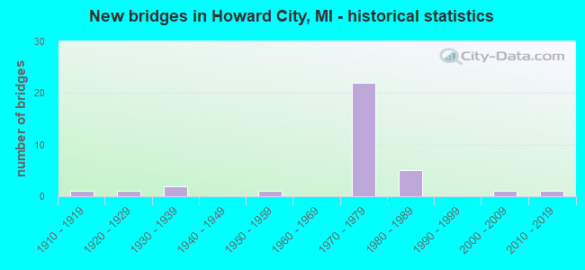
- New bridges - historical statistics
- 11910-1919
- 11920-1929
- 21930-1939
- 11950-1959
- 221970-1979
- 51980-1989
- 12000-2009
- 12010-2019

- Reconstructed bridges - Historical Statistics
- 11950-1959
- 01960-1969
- 11970-1979
- 01980-1989
- 01990-1999
- 32000-2009
- 12010-2019


- Bridge Condition - Deck
- 47.4%Good
- 47.4%Satisfactory
- 5.3%Fair

- Bridge Condition - Superstructure
- 31.6%Very good
- 31.6%Good
- 31.6%Satisfactory
- 5.3%Fair

- Bridge Condition - Substructure
- 15.8%Very good
- 52.6%Good
- 26.3%Satisfactory
- 5.3%Fair

- Bridge Condition - Channel
- 11.1%Very good
- 33.3%Good
- 44.4%Satisfactory
- 5.6%Fair
- 5.6%Poor

- Bridge Condition - Culverts
- 14.3%Very good
- 28.6%Good
- 28.6%Satisfactory
- 28.6%Fair
Find on map >> Show street view
Structure Number: 7266, Location: 0.12 MI E OF RAISINVILLE (Lat: 41.975800, Lng: -83.442728), Route carried "on" structure: County highway 5845, Year Built: 1980, Status: Open, Structure Length: 0.67m (2.20ft), Average Daily Traffic: 5,160 (year 2017), Truck Traffic: 1%, Average Future Daily Traffic: 5,933 (year 2037), Design Load: HS 20, Features Intersected: LITTLE SANDY CREEK, Facility Carried by Structure: BLUE BUSH ROAD
Minimum Vertical Clearance: 30.48m (100.00ft), Kilometerpoint: 8.382, Lanes on structure: 2, Owner: County Highway Agency, Approaching Roadway Width: 9.9m (32.5ft), Skew: 1 degrees, Material/Design: Concrete, Design/Construction: Culvert, Number Of Spans In Main Unit: 2, Length of Maximum Span: 3.0m (9.8ft), Curb-To-Curb Width: 9.1m (29.9ft), Out-to-Out Width: 20.1m (65.9ft)
Condition: Channel: Very good, Culverts: Fair, Operating Rating: 64.8 metric tons, Method Used To Determine Operating Rating: Load Factor (LF) rating reported by rating factor (RF) method using MS18 loading, Inventory Rating: 38.9 metric tons, Method Used To Determine Inventory Rating: Load Factor (LF) rating reported by rating factor (RF) method using MS18 loading, Structural Evaluation: Somewhat better than minimum adequacy, Deck Geometry: High priority of corrective action, Waterway Adequacy: Better than present minimum criteria, Approach Roadway Alignment: Equal to present desirable criteria, Designated Inspection Frequency: Every 24 months, Inspection Date: November 2020
Find on map >> Show street view
Structure Number: 7412, Location: 0.5 MI S OF M-82 (Lat: 43.390389, Lng: -85.517333), Route carried "on" structure: US 131, Year Built: 1972, Year Reconstructed: 2012, Status: Open, Structure Length: 5.09m (16.70ft), Average Daily Traffic: 26,700 (year 2011), Truck Traffic: 11%, Average Future Daily Traffic: 34,200 (year 2031), Design Load: H 20, Features Intersected: TAMARACK CREEK
Minimum Vertical Clearance: 30.48m (100.00ft), Kilometerpoint: 11.729, Lanes on structure: 3, Base Highway Network: Yes (Inventory Route: 120, Subroute: 1), Owner: State Highway Agency, Approaching Roadway Width: 15.2m (49.9ft), Material/Design: Prestressed concrete, Design/Construction: Stringer/Multi-beam, Number Of Spans In Main Unit: 3, Length of Maximum Span: 17.0m (55.8ft), Curb-To-Curb Width: 14.1m (46.3ft), Out-to-Out Width: 14.7m (48.2ft)
Condition: Deck: Satisfactory, Superstructure: Satisfactory, Substructure: Satisfactory, Channel: Good, Operating Rating: 76.5 metric tons, Method Used To Determine Operating Rating: Load Factor (LF) rating reported by rating factor (RF) method using MS18 loading, Inventory Rating: 40.8 metric tons, Method Used To Determine Inventory Rating: Load Factor (LF) rating reported by rating factor (RF) method using MS18 loading, Structural Evaluation: Equal to present minimum criteria, Deck Geometry: Somewhat better than minimum adequacy, Waterway Adequacy: Superior to present desirable criteria, Approach Roadway Alignment: Equal to present desirable criteria, Designated Inspection Frequency: Every 24 months, Inspection Date: July 2021, Deck Structure Type: Concrete Cast-file-Place, Wearing Surface/Protective System: Wearing Surface: Latex Concrete
Find on map >> Show street view
Structure Number: 7413, Location: 0.5 MI S OF M-82 (Lat: 43.390314, Lng: -85.515608), Route carried "on" structure: US 131, Year Built: 1972, Year Reconstructed: 2012, Status: Open, Structure Length: 4.94m (16.21ft), Average Daily Traffic: 26,700 (year 2011), Truck Traffic: 11%, Average Future Daily Traffic: 34,200 (year 2031), Design Load: HL 93, Features Intersected: TAMARACK CREEK
Minimum Vertical Clearance: 30.48m (100.00ft), Kilometerpoint: 11.729, Lanes on structure: 3, Base Highway Network: Yes (Inventory Route: 120, Subroute: 5), Owner: State Highway Agency, Approaching Roadway Width: 14.6m (47.9ft), Skew: 1 degrees, Material/Design: Prestressed concrete, Design/Construction: Stringer/Multi-beam, Number Of Spans In Main Unit: 3, Length of Maximum Span: 15.9m (52.2ft), Curb-To-Curb Width: 17.1m (56.1ft), Out-to-Out Width: 18.1m (59.4ft)
Condition: Deck: Satisfactory, Superstructure: Very good, Substructure: Good, Channel: Satisfactory, Operating Rating: 70.6 metric tons, Method Used To Determine Operating Rating: Load and Resistance Factor Rating (LRFR) rating reported by rating factor(RF) method using HL-93 loadings, Inventory Rating: 42.8 metric tons, Method Used To Determine Inventory Rating: Load and Resistance Factor Rating (LRFR) rating reported by rating factor(RF) method using HL-93 loadings, Structural Evaluation: Better than present minimum criteria, Deck Geometry: Superior to present desirable criteria, Waterway Adequacy: Superior to present desirable criteria, Approach Roadway Alignment: Equal to present desirable criteria, Designated Inspection Frequency: Every 24 months, Inspection Date: July 2021, Deck Structure Type: Concrete Cast-file-Place, Wearing Surface/Protective System: Wearing Surface: Monolithic Concrete, Deck Protection: Epoxy Coated Reinforcing
Find on map >> Show street view
Structure Number: 7414, Location: 0.5 MI N OF EDGAR RD, M46 (Lat: 43.433097, Lng: -85.493253), Route carried "on" structure: US 131, Year Built: 1979, Status: Open, Structure Length: 0.73m (2.40ft), Average Daily Traffic: 10,150 (year 2014), Truck Traffic: 9%, Average Future Daily Traffic: 11,800 (year 2034), Design Load: HS 20, Features Intersected: HANDY CREEK
Minimum Vertical Clearance: 30.48m (100.00ft), Kilometerpoint: 16.867, Lanes on structure: 2, Base Highway Network: Yes (Inventory Route: 120, Subroute: 5), Owner: State Highway Agency, Approaching Roadway Width: 11.0m (36.1ft), Material/Design: Concrete, Design/Construction: Culvert, Number Of Spans In Main Unit: 2, Length of Maximum Span: 3.2m (10.5ft), Curb-To-Curb Width: 10.1m (33.1ft), Out-to-Out Width: 11.0m (36.1ft)
Condition: Channel: Poor, Culverts: Good, Operating Rating: 97.2 metric tons, Method Used To Determine Operating Rating: Load Factor (LF) rating reported by rating factor (RF) method using MS18 loading, Inventory Rating: 75.5 metric tons, Method Used To Determine Inventory Rating: Load Factor (LF) rating reported by rating factor (RF) method using MS18 loading, Structural Evaluation: Better than present minimum criteria, Deck Geometry: Somewhat better than minimum adequacy, Waterway Adequacy: Equal to present minimum criteria, Approach Roadway Alignment: Equal to present desirable criteria, Designated Inspection Frequency: Every 24 months, Inspection Date: January 2021, Wearing Surface/Protective System: Wearing Surface: Bituminous
Find on map >> Show street view
Structure Number: 7415, Location: 0.5 MI N OF EDGAR RD (Lat: 43.433100, Lng: -85.494153), Route carried "on" structure: US 131, Year Built: 1979, Status: Open, Structure Length: 0.73m (2.40ft), Average Daily Traffic: 10,150 (year 2014), Truck Traffic: 9%, Average Future Daily Traffic: 11,800 (year 2034), Design Load: HS 20, Features Intersected: HANDY CREEK
Minimum Vertical Clearance: 30.48m (100.00ft), Kilometerpoint: 16.881, Lanes on structure: 2, Base Highway Network: Yes (Inventory Route: 120, Subroute: 1), Owner: State Highway Agency, Approaching Roadway Width: 11.0m (36.1ft), Material/Design: Concrete, Design/Construction: Culvert, Number Of Spans In Main Unit: 2, Length of Maximum Span: 3.2m (10.5ft), Curb-To-Curb Width: 10.1m (33.1ft), Out-to-Out Width: 11.0m (36.1ft)
Condition: Channel: Satisfactory, Culverts: Good, Operating Rating: 97.2 metric tons, Method Used To Determine Operating Rating: Load Factor (LF) rating reported by rating factor (RF) method using MS18 loading, Inventory Rating: 97.2 metric tons, Method Used To Determine Inventory Rating: Load Factor (LF) rating reported by rating factor (RF) method using MS18 loading, Structural Evaluation: Better than present minimum criteria, Deck Geometry: Somewhat better than minimum adequacy, Waterway Adequacy: Equal to present minimum criteria, Approach Roadway Alignment: Equal to present desirable criteria, Designated Inspection Frequency: Every 24 months, Inspection Date: January 2021, Wearing Surface/Protective System: Wearing Surface: Bituminous
Find on map >> Show street view
Structure Number: 7421, Location: 2.0 MI S OF M-82 (Lat: 43.366517, Lng: -85.516150), Route carried "on" structure: US 131, Year Built: 1971, Status: Open, Structure Length: 3.29m (10.79ft), Average Daily Traffic: 26,700 (year 2011), Truck Traffic: 12%, Average Future Daily Traffic: 34,200 (year 2031), Design Load: HS 20, Features Intersected: KENDAVILLE RD
Minimum Vertical Clearance: 30.48m (100.00ft), Kilometerpoint: 9.032, Lanes on structure: 2, Lanes under structure: 2, Base Highway Network: Yes (Inventory Route: 120, Subroute: 1), Owner: State Highway Agency, Approaching Roadway Width: 13.7m (44.9ft), Skew: 1 degrees, Material/Design: Steel, Design/Construction: Stringer/Multi-beam, Number Of Spans In Main Unit: 3, Length of Maximum Span: 15.8m (51.8ft), Curb-To-Curb Width: 12.3m (40.4ft), Out-to-Out Width: 13.3m (43.6ft)
Condition: Deck: Good, Superstructure: Good, Substructure: Good, Operating Rating: 57.3 metric tons, Method Used To Determine Operating Rating: Load Factor (LF) rating reported by rating factor (RF) method using MS18 loading, Inventory Rating: 34.3 metric tons, Method Used To Determine Inventory Rating: Load Factor (LF) rating reported by rating factor (RF) method using MS18 loading, Structural Evaluation: Better than present minimum criteria, Deck Geometry: Better than present minimum criteria, Underclear: Meets minimum limits, Approach Roadway Alignment: Equal to present desirable criteria, Designated Inspection Frequency: Every 24 months, Inspection Date: July 2021, Deck Structure Type: Concrete Cast-file-Place, Wearing Surface/Protective System: Wearing Surface: Epoxy Overlay
Find on map >> Show street view
Structure Number: 7422, Location: 2.0 MI S OF M-82 (Lat: 43.366533, Lng: -85.514367), Route carried "on" structure: US 131, Year Built: 1971, Status: Open, Structure Length: 3.37m (11.06ft), Average Daily Traffic: 26,700 (year 2011), Truck Traffic: 12%, Average Future Daily Traffic: 34,200 (year 2031), Design Load: HS 20, Features Intersected: KENDAVILLE RD
Minimum Vertical Clearance: 30.48m (100.00ft), Kilometerpoint: 9.034, Lanes on structure: 2, Lanes under structure: 2, Base Highway Network: Yes (Inventory Route: 120, Subroute: 5), Owner: State Highway Agency, Approaching Roadway Width: 13.7m (44.9ft), Skew: 1 degrees, Material/Design: Steel, Design/Construction: Stringer/Multi-beam, Number Of Spans In Main Unit: 3, Length of Maximum Span: 16.0m (52.5ft), Curb-To-Curb Width: 12.3m (40.4ft), Out-to-Out Width: 13.3m (43.6ft)
Condition: Deck: Satisfactory, Superstructure: Very good, Substructure: Good, Operating Rating: 61.2 metric tons, Method Used To Determine Operating Rating: Load Factor (LF) rating reported by rating factor (RF) method using MS18 loading, Inventory Rating: 36.6 metric tons, Method Used To Determine Inventory Rating: Load Factor (LF) rating reported by rating factor (RF) method using MS18 loading, Structural Evaluation: Better than present minimum criteria, Deck Geometry: Better than present minimum criteria, Underclear: Equal to present minimum criteria, Approach Roadway Alignment: Equal to present desirable criteria, Designated Inspection Frequency: Every 24 months, Inspection Date: July 2021, Deck Structure Type: Concrete Cast-file-Place, Wearing Surface/Protective System: Wearing Surface: Epoxy Overlay
Find on map >> Show street view
Structure Number: 7423, Location: 1.1 MI S OF M-82 (Lat: 43.381178, Lng: -85.519456), Route carried "on" structure: County highway , Year Built: 1971, Status: Open, Structure Length: 5.09m (16.70ft), Average Daily Traffic: 50 (year 1988), Average Future Daily Traffic: 58 (year 2008), Design Load: H 20, Features Intersected: US-131 SB, Facility Carried by Structure: LK MONTCALM RD
Minimum Vertical Clearance: 30.48m (100.00ft), Kilometerpoint: 3.502, Lanes on structure: 2, Lanes under structure: 2, Owner: State Highway Agency, Approaching Roadway Width: 12.2m (40.0ft), Material/Design: Steel, Design/Construction: Stringer/Multi-beam, Number Of Spans In Main Unit: 3, Length of Maximum Span: 28.0m (91.9ft), Curb or Sidewalk Widths: Left: 0.2m (0.7ft), Right: 0.2m (0.7ft), Curb-To-Curb Width: 12.2m (40.0ft), Out-to-Out Width: 12.9m (42.3ft)
Condition: Deck: Good, Superstructure: Good, Substructure: Good, Operating Rating: 72.6 metric tons, Method Used To Determine Operating Rating: Load Factor (LF) rating reported by rating factor (RF) method using MS18 loading, Inventory Rating: 41.1 metric tons, Method Used To Determine Inventory Rating: Load Factor (LF) rating reported by rating factor (RF) method using MS18 loading, Structural Evaluation: Better than present minimum criteria, Deck Geometry: Superior to present desirable criteria, Underclear: Superior to present desirable criteria, Approach Roadway Alignment: Equal to present desirable criteria, Designated Inspection Frequency: Every 24 months, Inspection Date: July 2021, Deck Structure Type: Concrete Cast-file-Place, Wearing Surface/Protective System: Wearing Surface: Monolithic Concrete
Find on map >> Show street view
Structure Number: 7424, Location: 1.1 MI S OF M-82 (Lat: 43.381189, Lng: -85.517956), Route carried "on" structure: County highway , Year Built: 1971, Status: Open, Structure Length: 5.06m (16.60ft), Average Daily Traffic: 50 (year 1988), Average Future Daily Traffic: 58 (year 2008), Design Load: H 20, Features Intersected: US-131 NB, Facility Carried by Structure: LK MONTCALM RD
Minimum Vertical Clearance: 30.48m (100.00ft), Kilometerpoint: 3.624, Lanes on structure: 2, Lanes under structure: 2, Owner: State Highway Agency, Approaching Roadway Width: 12.2m (40.0ft), Material/Design: Steel, Design/Construction: Stringer/Multi-beam, Number Of Spans In Main Unit: 3, Length of Maximum Span: 28.0m (91.9ft), Curb or Sidewalk Widths: Left: 0.2m (0.7ft), Right: 0.2m (0.7ft), Curb-To-Curb Width: 12.2m (40.0ft), Out-to-Out Width: 12.9m (42.3ft)
Condition: Deck: Good, Superstructure: Good, Substructure: Good, Operating Rating: 72.6 metric tons, Method Used To Determine Operating Rating: Load Factor (LF) rating reported by rating factor (RF) method using MS18 loading, Inventory Rating: 43.4 metric tons, Method Used To Determine Inventory Rating: Load Factor (LF) rating reported by rating factor (RF) method using MS18 loading, Structural Evaluation: Better than present minimum criteria, Deck Geometry: Superior to present desirable criteria, Underclear: Superior to present desirable criteria, Approach Roadway Alignment: Equal to present desirable criteria, Designated Inspection Frequency: Every 24 months, Inspection Date: July 2021, Deck Structure Type: Concrete Cast-file-Place, Wearing Surface/Protective System: Wearing Surface: Monolithic Concrete
Find on map >> Show street view
Structure Number: 7425, Location: @ M-82 (Lat: 43.395850, Lng: -85.514972), Route carried "on" structure: State highway 82, Year Built: 1971, Status: Open, Structure Length: 5.61m (18.41ft), Average Daily Traffic: 3,800 (year 2014), Truck Traffic: 13%, Average Future Daily Traffic: 4,370 (year 2034), Design Load: HS 20, Features Intersected: US-131 SB & M-46 SB
Minimum Vertical Clearance: 30.48m (100.00ft), Kilometerpoint: 3.858, Lanes on structure: 2, Lanes under structure: 2, Base Highway Network: Yes (Inventory Route: 120, Subroute: 1), Owner: State Highway Agency, Approaching Roadway Width: 17.0m (55.8ft), Skew: 1 degrees, Material/Design: Steel, Design/Construction: Stringer/Multi-beam, Number Of Spans In Main Unit: 3, Length of Maximum Span: 30.2m (99.1ft), Curb-To-Curb Width: 16.9m (55.4ft), Out-to-Out Width: 18.2m (59.7ft)
Condition: Deck: Satisfactory, Superstructure: Good, Substructure: Very good, Operating Rating: 67.4 metric tons, Method Used To Determine Operating Rating: Load Factor (LF) rating reported by rating factor (RF) method using MS18 loading, Inventory Rating: 40.5 metric tons, Method Used To Determine Inventory Rating: Load Factor (LF) rating reported by rating factor (RF) method using MS18 loading, Structural Evaluation: Better than present minimum criteria, Deck Geometry: Superior to present desirable criteria, Underclear: Better than present minimum criteria, Approach Roadway Alignment: Better than present minimum criteria, Designated Inspection Frequency: Every 24 months, Inspection Date: July 2021, Deck Structure Type: Concrete Cast-file-Place, Wearing Surface/Protective System: Wearing Surface: Latex Concrete, Deck Protection: Epoxy Coated Reinforcing
Find on map >> Show street view
Structure Number: 7426, Location: @ M-82 (Lat: 43.395844, Lng: -85.513458), Route carried "on" structure: State highway 82, Year Built: 1971, Status: Open, Structure Length: 5.75m (18.86ft), Average Daily Traffic: 3,800 (year 2014), Truck Traffic: 13%, Average Future Daily Traffic: 4,370 (year 2034), Design Load: HS 20, Features Intersected: US-131 NB & M-46 NB
Minimum Vertical Clearance: 30.48m (100.00ft), Kilometerpoint: 3.980, Lanes on structure: 2, Lanes under structure: 2, Base Highway Network: Yes (Inventory Route: 120, Subroute: 1), Owner: State Highway Agency, Approaching Roadway Width: 17.0m (55.8ft), Skew: 1 degrees, Material/Design: Steel, Design/Construction: Stringer/Multi-beam, Number Of Spans In Main Unit: 3, Length of Maximum Span: 30.1m (98.8ft), Curb-To-Curb Width: 16.9m (55.4ft), Out-to-Out Width: 18.2m (59.7ft)
Condition: Deck: Satisfactory, Superstructure: Good, Substructure: Good, Operating Rating: 68.7 metric tons, Method Used To Determine Operating Rating: Load Factor (LF) rating reported by rating factor (RF) method using MS18 loading, Inventory Rating: 41.1 metric tons, Method Used To Determine Inventory Rating: Load Factor (LF) rating reported by rating factor (RF) method using MS18 loading, Structural Evaluation: Better than present minimum criteria, Deck Geometry: Superior to present desirable criteria, Underclear: Superior to present desirable criteria, Approach Roadway Alignment: Better than present minimum criteria, Designated Inspection Frequency: Every 24 months, Inspection Date: July 2021, Deck Structure Type: Concrete Cast-file-Place, Wearing Surface/Protective System: Wearing Surface: Latex Concrete, Deck Protection: Epoxy Coated Reinforcing
Find on map >> Show street view
Structure Number: 7427, Location: 2.5 MI NW OF HOWARD CITY (Lat: 43.424831, Lng: -85.495517), Route carried "on" structure: State highway 46, Year Built: 1979, Status: Open, Structure Length: 11.22m (36.81ft), Average Daily Traffic: 6,427 (year 2007), Truck Traffic: 18%, Average Future Daily Traffic: 8,233 (year 2018), Design Load: HS 25 or greater, Features Intersected: US-131
Minimum Vertical Clearance: 30.48m (100.00ft), Kilometerpoint: 0.575, Lanes on structure: 2, Lanes under structure: 4, Base Highway Network: Yes (Inventory Route: 120, Subroute: 2), Owner: State Highway Agency, Approaching Roadway Width: 13.4m (44.0ft), Skew: 1 degrees, Material/Design: Steel, Design/Construction: Stringer/Multi-beam, Number Of Spans In Main Unit: 3, Length of Maximum Span: 37.8m (124.0ft), Curb-To-Curb Width: 15.0m (49.2ft), Out-to-Out Width: 15.8m (51.8ft)
Condition: Deck: Satisfactory, Superstructure: Very good, Substructure: Good, Operating Rating: 78.1 metric tons, Method Used To Determine Operating Rating: Load Factor (LF) rating reported by rating factor (RF) method using MS18 loading, Inventory Rating: 46.7 metric tons, Method Used To Determine Inventory Rating: Load Factor (LF) rating reported by rating factor (RF) method using MS18 loading, Structural Evaluation: Better than present minimum criteria, Deck Geometry: Superior to present desirable criteria, Underclear: Better than present minimum criteria, Approach Roadway Alignment: Equal to present desirable criteria, Length Of Structure Improvement: 11.22m (36.81ft), Designated Inspection Frequency: Every 24 months, Inspection Date: October 2021, Bridge Improvement Cost: $320,000, Roadway Improvement Cost: $16,000, Total Project Cost: $192,000, Deck Structure Type: Concrete Cast-file-Place, Wearing Surface/Protective System: Wearing Surface: Monolithic Concrete
Find on map >> Show street view
Structure Number: 7428, Location: 3.3 MI NW HOWARD CITY (Lat: 43.439333, Lng: -85.492264), Route carried "on" structure: County highway 59, Year Built: 1979, Status: Open, Structure Length: 13.99m (45.90ft), Average Daily Traffic: 550 (year 1988), Truck Traffic: 3%, Average Future Daily Traffic: 633 (year 2008), Design Load: H 20, Features Intersected: US-131, Facility Carried by Structure: TAMARACK ROAD
Minimum Vertical Clearance: 30.48m (100.00ft), Kilometerpoint: 1.643, Lanes on structure: 2, Lanes under structure: 4, Owner: State Highway Agency, Approaching Roadway Width: 10.3m (33.8ft), Material/Design: Steel continuous, Design/Construction: Stringer/Multi-beam, Number Of Spans In Main Unit: 4, Length of Maximum Span: 37.2m (122.0ft), Curb-To-Curb Width: 11.4m (37.4ft), Out-to-Out Width: 12.1m (39.7ft)
Condition: Deck: Good, Superstructure: Very good, Substructure: Good, Operating Rating: 63.5 metric tons, Method Used To Determine Operating Rating: Load Factor (LF) rating reported by rating factor (RF) method using MS18 loading, Inventory Rating: 37.9 metric tons, Method Used To Determine Inventory Rating: Load Factor (LF) rating reported by rating factor (RF) method using MS18 loading, Structural Evaluation: Better than present minimum criteria, Deck Geometry: Better than present minimum criteria, Underclear: Better than present minimum criteria, Approach Roadway Alignment: Equal to present desirable criteria, Length Of Structure Improvement: 13.99m (45.90ft), Designated Inspection Frequency: Every 24 months, Inspection Date: October 2021, Bridge Improvement Cost: $277,000, Roadway Improvement Cost: $14,000, Total Project Cost: $167,000, Deck Structure Type: Concrete Cast-file-Place, Wearing Surface/Protective System: Wearing Surface: Monolithic Concrete, Deck Protection: Epoxy Coated Reinforcing
Find on map >> Show street view
Structure Number: 7441, Location: 1.0 MI E OF NEWAYGO COL (Lat: 43.395844, Lng: -85.542839), Route carried "on" structure: State highway 82, Year Built: 1932, Year Reconstructed: 1961, Status: Open, Structure Length: 4.36m (14.30ft), Average Daily Traffic: 5,181 (year 2007), Truck Traffic: 13%, Average Future Daily Traffic: 4,721 (year 2018), Design Load: HS 20, Features Intersected: TAMARACK CREEK
Minimum Vertical Clearance: 30.48m (100.00ft), Kilometerpoint: 1.601, Lanes on structure: 2, Base Highway Network: Yes (Inventory Route: 120, Subroute: 1), Owner: State Highway Agency, Approaching Roadway Width: 13.4m (44.0ft), Material/Design: Steel, Design/Construction: Stringer/Multi-beam, Number Of Spans In Main Unit: 3, Length of Maximum Span: 26.5m (86.9ft), Curb-To-Curb Width: 12.8m (42.0ft), Out-to-Out Width: 13.7m (44.9ft)
Condition: Deck: Satisfactory, Superstructure: Fair, Substructure: Satisfactory, Channel: Satisfactory, Operating Rating: 55.4 metric tons, Method Used To Determine Operating Rating: Load Factor (LF) rating reported by rating factor (RF) method using MS18 loading, Inventory Rating: 33.0 metric tons, Method Used To Determine Inventory Rating: Load Factor (LF) rating reported by rating factor (RF) method using MS18 loading, Structural Evaluation: Somewhat better than minimum adequacy, Deck Geometry: Somewhat better than minimum adequacy, Waterway Adequacy: Somewhat better than minimum adequacy, Approach Roadway Alignment: Better than present minimum criteria, Designated Inspection Frequency: Every 24 months, Inspection Date: March 2021, Deck Structure Type: Concrete Cast-file-Place, Wearing Surface/Protective System: Wearing Surface: Latex Concrete
Find on map >> Show street view
Structure Number: 7459, Location: 3.8 MI S OF M-46 (Lat: 43.376989, Lng: -85.475500), Route carried "on" structure: County highway 131, Year Built: 2009, Status: Open, Structure Length: 1.28m (4.20ft), Average Daily Traffic: 6,000 (year 2006), Average Future Daily Traffic: 10,800 (year 2026), Features Intersected: RICE CR
Minimum Vertical Clearance: 30.48m (100.00ft), Kilometerpoint: 13.210, Lanes on structure: 2, Owner: County Highway Agency, Approaching Roadway Width: 12.8m (42.0ft), Material/Design: Prestressed concrete, Design/Construction: Box Beam or Girders - Single/Spread, Number Of Spans In Main Unit: 1, Length of Maximum Span: 11.6m (38.1ft), Curb-To-Curb Width: 12.2m (40.0ft), Out-to-Out Width: 12.8m (42.0ft)
Condition: Deck: Good, Superstructure: Very good, Substructure: Very good, Channel: Good, Operating Rating: 98.1 metric tons, Method Used To Determine Operating Rating: Load Factor (LF), Inventory Rating: 58.9 metric tons, Method Used To Determine Inventory Rating: Load Factor (LF), Structural Evaluation: Equal to present desirable criteria, Deck Geometry: Somewhat better than minimum adequacy, Waterway Adequacy: Equal to present desirable criteria, Approach Roadway Alignment: Better than present minimum criteria, Designated Inspection Frequency: Every 24 months, Inspection Date: September 2021, Deck Structure Type: Concrete Cast-file-Place, Wearing Surface/Protective System: Wearing Surface: Monolithic Concrete, Deck Protection: Epoxy Coated Reinforcing
Find on map >> Show street view
Structure Number: 7465, Location: 0.1 MI WEST MAPLE HILL RD (Lat: 43.439156, Lng: -85.483367), Route carried "on" structure: County highway , Year Built: 1976, Status: Open, Structure Length: 0.70m (2.30ft), Average Daily Traffic: 477 (year 2003), Average Future Daily Traffic: 733 (year 2023), Design Load: HS 20+Mod, Features Intersected: HANDY CREEK, Facility Carried by Structure: TAMARACK RD
Minimum Vertical Clearance: 30.48m (100.00ft), Kilometerpoint: 2.364, Lanes on structure: 2, Owner: County Highway Agency, Approaching Roadway Width: 9.1m (29.9ft), Material/Design: Wood or Timber, Design/Construction: Culvert, Number Of Spans In Main Unit: 3, Length of Maximum Span: 2.4m (7.9ft), Curb-To-Curb Width: 10.1m (33.1ft), Out-to-Out Width: 12.5m (41.0ft)
Condition: Channel: Satisfactory, Culverts: Fair, Operating Rating: 43.6 metric tons, Method Used To Determine Operating Rating: Allowable Stress (AS), Inventory Rating: 33.7 metric tons, Method Used To Determine Inventory Rating: Allowable Stress (AS), Structural Evaluation: Somewhat better than minimum adequacy, Deck Geometry: Equal to present minimum criteria, Waterway Adequacy: Better than present minimum criteria, Approach Roadway Alignment: Equal to present desirable criteria, Designated Inspection Frequency: Every 24 months, Inspection Date: September 2021, Deck Structure Type: Wood or Timber, Wearing Surface/Protective System: Wearing Surface: Bituminous
Find on map >> Show street view
Structure Number: 7466, Location: 0.2 MI WEST MAPLE HILL RD (Lat: 43.439244, Lng: -85.486844), Route carried "on" structure: County highway , Year Built: 1976, Status: Open, Structure Length: 0.70m (2.30ft), Average Daily Traffic: 533 (year 2003), Average Future Daily Traffic: 733 (year 2023), Design Load: HS 20+Mod, Features Intersected: HANDY CREEK, Facility Carried by Structure: TAMARACK RD
Minimum Vertical Clearance: 30.48m (100.00ft), Kilometerpoint: 2.083, Lanes on structure: 2, Owner: County Highway Agency, Approaching Roadway Width: 9.1m (29.9ft), Material/Design: Wood or Timber, Design/Construction: Culvert, Number Of Spans In Main Unit: 3, Length of Maximum Span: 2.4m (7.9ft), Curb-To-Curb Width: 10.1m (33.1ft), Out-to-Out Width: 12.5m (41.0ft)
Condition: Channel: Satisfactory, Culverts: Satisfactory, Operating Rating: 23.3 metric tons, Method Used To Determine Operating Rating: Load Factor (LF) rating reported by rating factor (RF) method using MS18 loading, Inventory Rating: 16.8 metric tons, Method Used To Determine Inventory Rating: Load Factor (LF) rating reported by rating factor (RF) method using MS18 loading, Structural Evaluation: Meets minimum limits, Deck Geometry: Equal to present minimum criteria, Waterway Adequacy: Equal to present desirable criteria, Approach Roadway Alignment: Equal to present desirable criteria, Designated Inspection Frequency: Every 24 months, Inspection Date: September 2021, Deck Structure Type: Wood or Timber, Wearing Surface/Protective System: Wearing Surface: Bituminous
Find on map >> Show street view
Structure Number: 7468, Location: TAMARACK AT MAPLE HILL RD (Lat: 43.438692, Lng: -85.482394), Route carried "on" structure: County highway , Year Built: 1987, Status: Open, Structure Length: 1.06m (3.48ft), Average Daily Traffic: 577 (year 2003), Average Future Daily Traffic: 833 (year 2023), Design Load: HS 20+Mod, Features Intersected: HANDY CREEK, Facility Carried by Structure: MAPLE HILL RD, 540
Minimum Vertical Clearance: 30.48m (100.00ft), Kilometerpoint: 3.966, Lanes on structure: 2, Owner: County Highway Agency, Approaching Roadway Width: 10.1m (33.1ft), Material/Design: Prestressed concrete, Design/Construction: Box Beam or Girders - Multiple, Number Of Spans In Main Unit: 1, Length of Maximum Span: 10.6m (34.8ft), Curb-To-Curb Width: 11.0m (36.1ft), Out-to-Out Width: 11.3m (37.1ft)
Condition: Deck: Good, Superstructure: Satisfactory, Substructure: Good, Channel: Fair, Operating Rating: 50.5 metric tons, Method Used To Determine Operating Rating: Load Factor (LF), Inventory Rating: 30.3 metric tons, Method Used To Determine Inventory Rating: Load Factor (LF), Structural Evaluation: Equal to present minimum criteria, Deck Geometry: Better than present minimum criteria, Waterway Adequacy: Equal to present desirable criteria, Approach Roadway Alignment: Equal to present desirable criteria, Designated Inspection Frequency: Every 24 months, Inspection Date: September 2021, Deck Structure Type: Concrete Precast Panels, Wearing Surface/Protective System: Wearing Surface: Bituminous, Membrane: Preformed Fabric, Deck Protection: Epoxy Coated Reinforcing
Find on map >> Show street view
Structure Number: 7478, Location: 0.3 MI. E OF US 131 (Lat: 43.395808, Lng: -85.504208), Route carried "on" structure: County highway 5978, Year Built: 1957, Year Reconstructed: 2015, Status: Open, Structure Length: 1.98m (6.50ft), Average Daily Traffic: 5,843 (year 2015), Truck Traffic: 5%, Average Future Daily Traffic: 6,785 (year 2035), Design Load: HS 20+Mod, Features Intersected: TAMARACK CR, Facility Carried by Structure: OLD M-82
Minimum Vertical Clearance: 30.48m (100.00ft), Kilometerpoint: 4.730, Lanes on structure: 2, Owner: County Highway Agency, Approaching Roadway Width: 11.6m (38.1ft), Skew: 2 degrees, Material/Design: Steel, Design/Construction: Stringer/Multi-beam, Number Of Spans In Main Unit: 1, Length of Maximum Span: 19.8m (65.0ft), Curb or Sidewalk Widths: Left: 0.4m (1.3ft), Right: 0.4m (1.3ft), Curb-To-Curb Width: 11.6m (38.1ft), Out-to-Out Width: 13.2m (43.3ft)
Condition: Deck: Good, Superstructure: Satisfactory, Substructure: Satisfactory, Channel: Good, Operating Rating: 97.2 metric tons, Method Used To Determine Operating Rating: Load Factor (LF) rating reported by rating factor (RF) method using MS18 loading, Inventory Rating: 61.2 metric tons, Method Used To Determine Inventory Rating: Load Factor (LF) rating reported by rating factor (RF) method using MS18 loading, Structural Evaluation: Equal to present minimum criteria, Deck Geometry: Somewhat better than minimum adequacy, Waterway Adequacy: Equal to present minimum criteria, Approach Roadway Alignment: Equal to present minimum criteria, Designated Inspection Frequency: Every 24 months, Inspection Date: September 2021, Deck Structure Type: Concrete Cast-file-Place, Wearing Surface/Protective System: Wearing Surface: Latex Concrete, Deck Protection: Epoxy Coated Reinforcing
Find on map >> Show street view
Structure Number: 7518, Location: 0.60 SOUTH OF TAMARACK RD (Lat: 43.432253, Lng: -85.537839), Route carried "on" structure: County highway , Year Built: 1987, Status: Open, Structure Length: 2.31m (7.58ft), Average Daily Traffic: 124 (year 2010), Average Future Daily Traffic: 184 (year 2030), Design Load: HS 20+Mod, Features Intersected: LITTLE MUSKEGON RIVER, Facility Carried by Structure: DAGGET ROAD
Minimum Vertical Clearance: 30.48m (100.00ft), Kilometerpoint: 4.328, Lanes on structure: 2, Owner: County Highway Agency, Approaching Roadway Width: 6.4m (21.0ft), Skew: 2 degrees, Material/Design: Prestressed concrete, Design/Construction: Box Beam or Girders - Multiple, Number Of Spans In Main Unit: 1, Length of Maximum Span: 23.1m (75.8ft), Curb-To-Curb Width: 9.1m (29.9ft), Out-to-Out Width: 10.9m (35.8ft)
Condition: Deck: Satisfactory, Superstructure: Satisfactory, Substructure: Very good, Channel: Good, Operating Rating: 61.0 metric tons, Method Used To Determine Operating Rating: Load Factor (LF), Inventory Rating: 36.5 metric tons, Method Used To Determine Inventory Rating: Load Factor (LF), Structural Evaluation: Equal to present minimum criteria, Deck Geometry: Equal to present minimum criteria, Waterway Adequacy: Equal to present desirable criteria, Approach Roadway Alignment: Equal to present minimum criteria, Designated Inspection Frequency: Every 24 months, Inspection Date: March 2021, Deck Structure Type: Concrete Precast Panels, Wearing Surface/Protective System: Wearing Surface: Bituminous, Membrane: Built-up
Find on map >> Show street view
Structure Number: 7519, Location: 1 MILE NORTH OF M-46 (Lat: 43.443186, Lng: -85.462558), Route carried "on" structure: County highway , Year Built: 1910, Status: Open, Structure Length: 1.06m (3.48ft), Average Daily Traffic: 120 (year 2003), Average Future Daily Traffic: 160 (year 2023), Design Load: HS 20+Mod, Features Intersected: HANDY CREEK, Facility Carried by Structure: REED ROAD
Minimum Vertical Clearance: 30.48m (100.00ft), Kilometerpoint: 2.041, Lanes on structure: 2, Owner: County Highway Agency, Approaching Roadway Width: 6.1m (20.0ft), Material/Design: Concrete, Design/Construction: Girder and Floorbeam System, Number Of Spans In Main Unit: 1, Length of Maximum Span: 9.7m (31.8ft), Curb-To-Curb Width: 6.1m (20.0ft), Out-to-Out Width: 7.5m (24.6ft)
Condition: Deck: Fair, Superstructure: Satisfactory, Substructure: Satisfactory, Channel: Satisfactory, Operating Rating: 20.2 metric tons, Method Used To Determine Operating Rating: Field evaluation and documented engineering judgment, Inventory Rating: 8.2 metric tons, Method Used To Determine Inventory Rating: Field evaluation and documented engineering judgment, Structural Evaluation: High priority of corrective action, Deck Geometry: Meets minimum limits, Waterway Adequacy: Equal to present desirable criteria, Approach Roadway Alignment: Equal to present desirable criteria, Designated Inspection Frequency: Every 24 months, Inspection Date: March 2021, Deck Structure Type: Concrete Cast-file-Place, Wearing Surface/Protective System: Wearing Surface: Bituminous
Find on map >> Show street view
Structure Number: 7525, Location: 0.10 EAST OF MARBLE ROAD (Lat: 43.399308, Lng: -85.410931), Route carried "on" structure: County highway , Year Built: 1983, Status: Open, Structure Length: 1.22m (4.00ft), Average Daily Traffic: 107 (year 2003), Average Future Daily Traffic: 146 (year 2023), Design Load: HS 20+Mod, Features Intersected: TAMARACK CREEK, Facility Carried by Structure: DEANER ROAD
Minimum Vertical Clearance: 30.48m (100.00ft), Kilometerpoint: 4.221, Lanes on structure: 2, Owner: County Highway Agency, Approaching Roadway Width: 4.9m (16.1ft), Material/Design: Wood or Timber, Design/Construction: Slab, Number Of Spans In Main Unit: 2, Length of Maximum Span: 6.1m (20.0ft), Curb-To-Curb Width: 8.5m (27.9ft), Out-to-Out Width: 9.0m (29.5ft)
Condition: Deck: Good, Superstructure: Good, Substructure: Good, Channel: Good, Operating Rating: 65.0 metric tons, Method Used To Determine Operating Rating: Allowable Stress (AS), Inventory Rating: 47.2 metric tons, Method Used To Determine Inventory Rating: Allowable Stress (AS), Structural Evaluation: Better than present minimum criteria, Deck Geometry: Equal to present minimum criteria, Waterway Adequacy: Somewhat better than minimum adequacy, Approach Roadway Alignment: Equal to present desirable criteria, Designated Inspection Frequency: Every 24 months, Inspection Date: April 2021, Deck Structure Type: Wood or Timber, Wearing Surface/Protective System: Wearing Surface: Bituminous
Find on map >> Show street view
Structure Number: 7526, Location: 0.75 WEST OF AMBLE ROAD (Lat: 43.410192, Lng: -85.397150), Route carried "on" structure: County highway , Year Built: 1980, Status: Open, Structure Length: 0.91m (2.99ft), Average Daily Traffic: 63 (year 1998), Average Future Daily Traffic: 88 (year 2018), Design Load: HS 20+Mod, Features Intersected: TAMARACK CREEK, Facility Carried by Structure: ALMY ROAD
Minimum Vertical Clearance: 30.48m (100.00ft), Kilometerpoint: 8.834, Lanes on structure: 2, Owner: County Highway Agency, Approaching Roadway Width: 6.7m (22.0ft), Material/Design: Wood or Timber, Design/Construction: Culvert, Number Of Spans In Main Unit: 4, Length of Maximum Span: 2.1m (6.9ft), Curb-To-Curb Width: 10.7m (35.1ft), Out-to-Out Width: 10.9m (35.8ft)
Condition: Channel: Satisfactory, Culverts: Satisfactory, Operating Rating: 69.0 metric tons, Method Used To Determine Operating Rating: Allowable Stress (AS), Inventory Rating: 51.0 metric tons, Method Used To Determine Inventory Rating: Allowable Stress (AS), Structural Evaluation: Equal to present minimum criteria, Deck Geometry: Superior to present desirable criteria, Waterway Adequacy: Somewhat better than minimum adequacy, Approach Roadway Alignment: Somewhat better than minimum adequacy, Designated Inspection Frequency: Every 24 months, Inspection Date: April 2021, Deck Structure Type: Wood or Timber, Wearing Surface/Protective System: Wearing Surface: Gravel
Find on map >> Show street view
Structure Number: 7533, Location: HOWARD CITY (Lat: 43.397342, Lng: -85.462478), Route carried "on" structure: County highway , Year Built: 1930, Year Reconstructed: 2000, Status: Open, Structure Length: 1.86m (6.10ft), Average Daily Traffic: 570 (year 2004), Average Future Daily Traffic: 866 (year 2024), Design Load: HS 20+Mod, Features Intersected: TAMARACK CREEK, Facility Carried by Structure: ORTON ROAD
Minimum Vertical Clearance: 30.48m (100.00ft), Kilometerpoint: 4.175, Lanes on structure: 2, Base Highway Network: Yes (Inventory Route: 120, Subroute: 10), Owner: City or Municipal Highway Agency, Approaching Roadway Width: 9.1m (29.9ft), Skew: 1 degrees, Material/Design: Prestressed concrete, Design/Construction: Box Beam or Girders - Multiple, Number Of Spans In Main Unit: 1, Length of Maximum Span: 17.4m (57.1ft), Curb or Sidewalk Widths: Left: 2.0m (6.6ft), Right: 0.0m, Curb-To-Curb Width: 8.5m (27.9ft), Out-to-Out Width: 11.5m (37.7ft)
Condition: Deck: Good, Superstructure: Very good, Substructure: Satisfactory, Channel: Good, Operating Rating: 86.2 metric tons, Method Used To Determine Operating Rating: Load and Resistance Factor Rating (LRFR) rating reported by rating factor(RF) method using HL-93 loadings, Inventory Rating: 66.4 metric tons, Method Used To Determine Inventory Rating: Load and Resistance Factor Rating (LRFR) rating reported by rating factor(RF) method using HL-93 loadings, Structural Evaluation: Equal to present minimum criteria, Deck Geometry: Somewhat better than minimum adequacy, Waterway Adequacy: Better than present minimum criteria, Approach Roadway Alignment: Better than present minimum criteria, Designated Inspection Frequency: Every 24 months, Inspection Date: October 2020, Deck Structure Type: Concrete Cast-file-Place, Wearing Surface/Protective System: Wearing Surface: Monolithic Concrete, Deck Protection: Epoxy Coated Reinforcing
Find on map >> Show street view
Structure Number: 7534, Location: IN HOWARD CITY (Lat: 43.400947, Lng: -85.468714), Route carried "on" structure: County highway 131, Year Built: 1928, Year Reconstructed: 1977, Status: Open, Structure Length: 1.52m (4.99ft), Average Daily Traffic: 8,200 (year 2003), Average Future Daily Traffic: 12,250 (year 2024), Design Load: HS 25 or greater, Features Intersected: TAMARACK CR
Minimum Vertical Clearance: 30.48m (100.00ft), Kilometerpoint: 12.457, Lanes on structure: 2, Owner: City or Municipal Highway Agency, Approaching Roadway Width: 15.2m (49.9ft), Skew: 3 degrees, Material/Design: Steel, Design/Construction: Stringer/Multi-beam, Number Of Spans In Main Unit: 1, Length of Maximum Span: 15.2m (49.9ft), Curb-To-Curb Width: 14.6m (47.9ft), Out-to-Out Width: 15.1m (49.5ft)
Condition: Deck: Satisfactory, Superstructure: Satisfactory, Substructure: Fair, Channel: Satisfactory, Operating Rating: 48.9 metric tons, Method Used To Determine Operating Rating: Load and Resistance Factor Rating (LRFR) rating reported by rating factor(RF) method using HL-93 loadings, Inventory Rating: 37.9 metric tons, Method Used To Determine Inventory Rating: Load and Resistance Factor Rating (LRFR) rating reported by rating factor(RF) method using HL-93 loadings, Structural Evaluation: Somewhat better than minimum adequacy, Deck Geometry: Superior to present desirable criteria, Waterway Adequacy: Better than present minimum criteria, Approach Roadway Alignment: Better than present minimum criteria, Bridge Posting: Required (Relationship of Operating Rating to Maximum Legal Load: 0.1 - 9.9% below), Designated Inspection Frequency: Every 24 months, Inspection Date: October 2020, Deck Structure Type: Concrete Cast-file-Place, Wearing Surface/Protective System: Wearing Surface: Monolithic Concrete
Find on map >> Show street view
Structure Number: 13813, Location: 0.2 MI EAST OF FEDERAL RD (Lat: 43.366717, Lng: -85.474872), Route carried "on" structure: County highway 530, Year Built: 2014, Status: Open, Structure Length: 0.67m (2.20ft), Average Daily Traffic: 1,525 (year 2010), Truck Traffic: 3%, Average Future Daily Traffic: 1,770 (year 2020), Design Load: HL 93, Features Intersected: HERRON DRAIN, Facility Carried by Structure: KENDAVILLE ROAD
Minimum Vertical Clearance: 30.48m (100.00ft), Kilometerpoint: 7.114, Lanes on structure: 2, Owner: County Highway Agency, Approaching Roadway Width: 8.5m (27.9ft), Skew: 4 degrees, Material/Design: Concrete, Design/Construction: Culvert, Number Of Spans In Main Unit: 1, Length of Maximum Span: 6.1m (20.0ft), Curb-To-Curb Width: 8.5m (27.9ft), Out-to-Out Width: 11.0m (36.1ft)
Condition: Channel: Very good, Culverts: Very good, Operating Rating: 56.1 metric tons, Method Used To Determine Operating Rating: Load and Resistance Factor Rating (LRFR) rating reported by rating factor(RF) method using HL-93 loadings, Inventory Rating: 43.1 metric tons, Method Used To Determine Inventory Rating: Load and Resistance Factor Rating (LRFR) rating reported by rating factor(RF) method using HL-93 loadings, Structural Evaluation: Equal to present desirable criteria, Deck Geometry: Somewhat better than minimum adequacy, Waterway Adequacy: Better than present minimum criteria, Approach Roadway Alignment: Better than present minimum criteria, Designated Inspection Frequency: Every 24 months, Inspection Date: September 2021, Wearing Surface/Protective System: Wearing Surface: Bituminous
Find on map >> Show street view
Structure Number: 7421, Location: 2.0 MI S OF M-82 (Lat: 43.366517, Lng: -85.516150), Route carried "under" structure: County highway 5964, Year Built: 1971, Structure Length: 0. m, Average Daily Traffic: 180 (year 1988), Features Intersected: KENDAVILLE RD, Facility Carried by Structure: US-131 & M-46 SB
Minimum Vertical Clearance: 4.32m (14.17ft), Kilometerpoint: 3.768, Lanes on structure: 2, Lanes under structure: 2, Material/Design: Steel, Design/Construction: Stringer/Multi-beam, Length of Maximum Span: 15.8m (51.8ft)
Find on map >> Show street view
Structure Number: 7422, Location: 2.0 MI S OF M-82 (Lat: 43.366533, Lng: -85.514367), Route carried "under" structure: County highway 5964, Year Built: 1971, Structure Length: 0. m, Average Daily Traffic: 180 (year 1988), Features Intersected: KENDAVILLE RD, Facility Carried by Structure: US-131 & M-46 NB
Minimum Vertical Clearance: 30+ m (98+ ft), Kilometerpoint: 3.912, Lanes on structure: 2, Lanes under structure: 2, Material/Design: Steel, Design/Construction: Stringer/Multi-beam, Length of Maximum Span: 16.0m (52.5ft)
Find on map >> Show street view
Structure Number: 7423, Location: 1.1 MI S OF M-82 (Lat: 43.381178, Lng: -85.519456), Route carried "under" structure: US 131, Year Built: 1971, Structure Length: 0. m, Average Daily Traffic: 12,542 (year 2007), Truck Traffic: 11%, Features Intersected: US-131 SB, Facility Carried by Structure: LK MONTCALM RD
Minimum Vertical Clearance: 5.08m (16.67ft), Kilometerpoint: 10.688, Lanes on structure: 2, Lanes under structure: 2, Material/Design: Steel, Design/Construction: Stringer/Multi-beam, Length of Maximum Span: 28.0m (91.9ft)
Find on map >> Show street view
Structure Number: 7424, Location: 1.1 MI S OF M-82 (Lat: 43.381189, Lng: -85.517956), Route carried "under" structure: US 131, Year Built: 1971, Structure Length: 0. m, Average Daily Traffic: 12,542 (year 2007), Truck Traffic: 11%, Features Intersected: US-131 NB, Facility Carried by Structure: LK MONTCALM RD
Minimum Vertical Clearance: 5.05m (16.57ft), Kilometerpoint: 10.696, Lanes on structure: 2, Lanes under structure: 2, Material/Design: Steel, Design/Construction: Stringer/Multi-beam, Length of Maximum Span: 28.0m (91.9ft)
Find on map >> Show street view
Structure Number: 7425, Location: @ M-82 (Lat: 43.395850, Lng: -85.514972), Route carried "under" structure: US 131, Year Built: 1971, Structure Length: 0. m, Average Daily Traffic: 11,000 (year 2014), Truck Traffic: 10%, Features Intersected: US-131 SB & M-46 SB, Facility Carried by Structure: M-82
Minimum Vertical Clearance: 5.00m (16.40ft), Kilometerpoint: 12.365, Lanes on structure: 2, Lanes under structure: 2, Material/Design: Steel, Design/Construction: Stringer/Multi-beam, Length of Maximum Span: 30.2m (99.1ft)
Find on map >> Show street view
Structure Number: 7426, Location: @ M-82 (Lat: 43.395844, Lng: -85.513458), Route carried "under" structure: US 131, Year Built: 1971, Structure Length: 0. m, Average Daily Traffic: 11,000 (year 2014), Truck Traffic: 10%, Features Intersected: US-131 NB & M-46 NB, Facility Carried by Structure: M-82
Minimum Vertical Clearance: 5.36m (17.59ft), Kilometerpoint: 12.368, Lanes on structure: 2, Lanes under structure: 2, Material/Design: Steel, Design/Construction: Stringer/Multi-beam, Length of Maximum Span: 30.1m (98.8ft)
Find on map >> Show street view
Structure Number: 7427, Location: 2.5 MI NW OF HOWARD CITY (Lat: 43.424831, Lng: -85.495517), Route carried "under" structure: US 131, Year Built: 1979, Structure Length: 0. m, Average Daily Traffic: 22,824 (year 2007), Truck Traffic: 10%, Features Intersected: US-131, Facility Carried by Structure: M-46 (EXTEN)
Minimum Vertical Clearance: 5.26m (17.26ft), Kilometerpoint: 15.928, Lanes on structure: 2, Lanes under structure: 4, Material/Design: Steel, Design/Construction: Stringer/Multi-beam, Length of Maximum Span: 37.8m (124.0ft)
Find on map >> Show street view
Structure Number: 7428, Location: 3.3 MI NW HOWARD CITY (Lat: 43.439333, Lng: -85.492264), Route carried "under" structure: US 131, Year Built: 1979, Structure Length: 0. m, Average Daily Traffic: 19,000 (year 2007), Truck Traffic: 10%, Features Intersected: US-131, Facility Carried by Structure: TAMARACK ROAD
Minimum Vertical Clearance: 5.28m (17.32ft), Kilometerpoint: 17.563, Lanes on structure: 2, Lanes under structure: 4, Material/Design: Steel continuous, Design/Construction: Stringer/Multi-beam, Length of Maximum Span: 37.2m (122.0ft)