Bridge Statistics for Houston, Pennsylvania (PA)
Condition, Traffic, Stress, Structural Evaluation, Project Costs
- National Bridge Inventory (NBI) Statistics
- 17Number of bridges
- 194ft / 58.5mTotal length
- $7,257,000Total costs
- 158,273Total average daily traffic
- 17,514Total average daily truck traffic
- National Bridge Inventory (NBI) Registered Bridges for Houston
- No street view available for this location
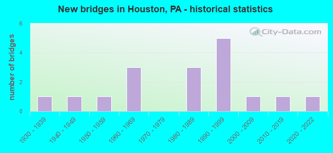
- New bridges - historical statistics
- 11930-1939
- 11940-1949
- 11950-1959
- 31960-1969
- 31980-1989
- 51990-1999
- 12000-2009
- 12010-2019
- 12020-2022

- Reconstructed bridges - Historical Statistics
- 11970-1979
- 01980-1989
- 11990-1999
- 02000-2009
- 22010-2019


- Bridge Condition - Deck
- 7.1%Excellent
- 14.3%Very good
- 42.9%Good
- 28.6%Satisfactory
- 7.1%Fair

- Bridge Condition - Superstructure
- 7.1%Excellent
- 14.3%Very good
- 28.6%Good
- 35.7%Satisfactory
- 14.3%Fair

- Bridge Condition - Substructure
- 7.1%Excellent
- 35.7%Good
- 50.0%Satisfactory
- 7.1%Fair

- Bridge Condition - Channel
- 11.1%Very good
- 55.6%Satisfactory
- 22.2%Fair
- 11.1%Poor
Find on map >> Show street view
Structure Number: 7179, Location: .2MI.EAST PA 413 42F01 (Lat: 40.157769, Lng: -74.891383), Route carried "on" structure: State highway , Year Built: 1957, Year Reconstructed: 2010, Status: Open, Structure Length: 1.49m (4.89ft), Average Daily Traffic: 12,353 (year 2022), Truck Traffic: 3%, Average Future Daily Traffic: 16,408 (year 2032), Design Load: HL 93, Features Intersected: MILL CREEK, Facility Carried by Structure: TRENTON ROAD
Minimum Vertical Clearance: 30+ m (98+ ft), Kilometerpoint: 2.108, Lanes on structure: 2, Owner: State Highway Agency, Approaching Roadway Width: 12.8m (42.0ft), Skew: 2 degrees, Material/Design: Prestressed concrete, Design/Construction: Box Beam or Girders - Multiple, Number Of Spans In Main Unit: 1, Length of Maximum Span: 14.0m (45.9ft), Curb-To-Curb Width: 12.3m (40.4ft), Out-to-Out Width: 13.2m (43.3ft)
Condition: Deck: Very good, Superstructure: Very good, Substructure: Satisfactory, Channel: Poor, Operating Rating: 62.9 metric tons, Method Used To Determine Operating Rating: Assigned ratings based on Load and Resistance Factor Design (LRFD) reported by rating factor (RF) using HL93 loadings, Inventory Rating: 39.5 metric tons, Method Used To Determine Inventory Rating: Assigned ratings based on Load and Resistance Factor Design (LRFD) reported by rating factor (RF) using HL93 loadings, Structural Evaluation: Equal to present minimum criteria, Deck Geometry: Somewhat better than minimum adequacy, Waterway Adequacy: Equal to present minimum criteria, Approach Roadway Alignment: Equal to present desirable criteria, Length Of Structure Improvement: 2.20m (7.22ft), Designated Inspection Frequency: Every 24 months, Inspection Date: October 2020, Bridge Improvement Cost: $7,000, Roadway Improvement Cost: $20,000, Total Project Cost: $92,000, Deck Structure Type: Concrete Cast-file-Place, Wearing Surface/Protective System: Wearing Surface: Monolithic Concrete, Membrane: Other, Deck Protection: Epoxy Coated Reinforcing
Find on map >> Show street view
Structure Number: 11764, Location: 2 MI E EXIT 133 (Lat: 40.980269, Lng: -78.133086), Route carried "on" structure: State highway , Year Built: 1968, Status: Open, Structure Length: 10.21m (33.50ft), Average Daily Traffic: 691 (year 2022), Truck Traffic: 1%, Average Future Daily Traffic: 822 (year 2041), Design Load: HS 20, Features Intersected: SR 80-I 80, Facility Carried by Structure: SR 2035
Minimum Vertical Clearance: 30+ m (98+ ft), Kilometerpoint: 10.194, Lanes on structure: 2, Lanes under structure: 4, Owner: State Highway Agency, Approaching Roadway Width: 6.4m (21.0ft), Skew: 33 degrees, Material/Design: Prestressed concrete, Design/Construction: Box Beam or Girders - Single/Spread, Number Of Spans In Main Unit: 5, Length of Maximum Span: 21.6m (70.9ft), Curb or Sidewalk Widths: Left: 0.5m (1.6ft), Right: 0.5m (1.6ft), Curb-To-Curb Width: 8.6m (28.2ft), Out-to-Out Width: 10.2m (33.5ft)
Condition: Deck: Fair, Superstructure: Satisfactory, Substructure: Satisfactory, Operating Rating: 71.7 metric tons, Method Used To Determine Operating Rating: Load Factor (LF), Inventory Rating: 29.0 metric tons, Method Used To Determine Inventory Rating: Load Factor (LF), Structural Evaluation: Equal to present minimum criteria, Deck Geometry: Somewhat better than minimum adequacy, Underclear: Meets minimum limits, Approach Roadway Alignment: Equal to present desirable criteria, Length Of Structure Improvement: 10.20m (33.46ft), Designated Inspection Frequency: Every 24 months, Inspection Date: July 2021, Bridge Improvement Cost: $64,000, Roadway Improvement Cost: $250,000, Total Project Cost: $861,000, Deck Structure Type: Concrete Cast-file-Place, Wearing Surface/Protective System: Wearing Surface: Latex Concrete
Find on map >> Show street view
Structure Number: 12912, Location: CENTERVILLE BOROUGH (Lat: 41.734989, Lng: -79.762953), Route carried "on" structure: State highway 8, Year Built: 1930, Year Reconstructed: 1979, Status: Open, Structure Length: 4.27m (14.01ft), Average Daily Traffic: 2,881 (year 2020), Truck Traffic: 10%, Average Future Daily Traffic: 4,323 (year 2032), Design Load: HS 15, Features Intersected: OVER OIL CREEK EAST BR
Minimum Vertical Clearance: 30+ m (98+ ft), Kilometerpoint: 16.319, Lanes on structure: 2, Base Highway Network: Yes, Owner: State Highway Agency, Approaching Roadway Width: 9.1m (29.9ft), Material/Design: Steel, Design/Construction: Girder and Floorbeam System, Number Of Spans In Main Unit: 2, Length of Maximum Span: 20.7m (67.9ft), Curb or Sidewalk Widths: Left: 1.6m (5.2ft), Right: 0.0m, Curb-To-Curb Width: 9.1m (29.9ft), Out-to-Out Width: 12.0m (39.4ft)
Condition: Deck: Satisfactory, Superstructure: Fair, Substructure: Fair, Channel: Fair, Operating Rating: 46.3 metric tons, Method Used To Determine Operating Rating: Load Factor (LF), Inventory Rating: 27.2 metric tons, Method Used To Determine Inventory Rating: Load Factor (LF), Structural Evaluation: Somewhat better than minimum adequacy, Deck Geometry: Meets minimum limits, Waterway Adequacy: Equal to present minimum criteria, Approach Roadway Alignment: Equal to present desirable criteria, Length Of Structure Improvement: 4.30m (14.11ft), Designated Inspection Frequency: Every 24 months, Critical Feature Inspection Frequency: Every 24 months, Inspection Date: May 2020, Critical Feature Inspection Date: May 2020, Bridge Improvement Cost: $93,000, Roadway Improvement Cost: $273,000, Total Project Cost: $1,253,000, Deck Structure Type: Concrete Cast-file-Place, Wearing Surface/Protective System: Wearing Surface: Bituminous, Membrane: Preformed Fabric, Deck Protection: Epoxy Coated Reinforcing
Find on map >> Show street view
Structure Number: 14424, Location: WILLIAMSTOWN BORO (Lat: 40.579344, Lng: -76.614397), Route carried "on" structure: State highway , Year Built: 1985, Status: Open, Structure Length: 2.07m (6.79ft), Average Daily Traffic: 1,048 (year 2022), Truck Traffic: 4%, Average Future Daily Traffic: 1,479 (year 2032), Design Load: HS 25 or greater, Features Intersected: WICONISCO CREEK, Facility Carried by Structure: SR 1005
Minimum Vertical Clearance: 30+ m (98+ ft), Kilometerpoint: 0.000, Lanes on structure: 2, Owner: State Highway Agency, Approaching Roadway Width: 7.3m (24.0ft), Material/Design: Prestressed concrete, Design/Construction: Box Beam or Girders - Multiple, Number Of Spans In Main Unit: 1, Length of Maximum Span: 20.4m (66.9ft), Curb or Sidewalk Widths: Left: 0.2m (0.7ft), Right: 1.2m (3.9ft), Curb-To-Curb Width: 8.5m (27.9ft), Out-to-Out Width: 10.6m (34.8ft)
Condition: Deck: Good, Superstructure: Satisfactory, Substructure: Good, Channel: Satisfactory, Operating Rating: 64.4 metric tons, Method Used To Determine Operating Rating: Load Factor (LF), Inventory Rating: 18.1 metric tons, Method Used To Determine Inventory Rating: Load Factor (LF), Structural Evaluation: Somewhat better than minimum adequacy, Deck Geometry: Somewhat better than minimum adequacy, Waterway Adequacy: Better than present minimum criteria, Approach Roadway Alignment: Equal to present desirable criteria, Length Of Structure Improvement: 2.70m (8.86ft), Designated Inspection Frequency: Every 24 months, Inspection Date: July 2020, Deck Structure Type: Concrete Cast-file-Place, Wearing Surface/Protective System: Wearing Surface: Monolithic Concrete, Deck Protection: Epoxy Coated Reinforcing
Find on map >> Show street view
Structure Number: 17783, Location: OVER PA 915 AT EXIT 151 (Lat: 39.948925, Lng: -78.231308), Route carried "on" structure: Interstate 70, Year Built: 1963, Year Reconstructed: 2004, Status: Open, Structure Length: 7.99m (26.21ft), Average Daily Traffic: 7,675 (year 2020), Truck Traffic: 37%, Average Future Daily Traffic: 10,050 (year 2032), Design Load: HS 20+Mod, Features Intersected: SR 915&3023; L.BRUSH CRK
Minimum Vertical Clearance: 30+ m (98+ ft), Kilometerpoint: 0.000, Lanes on structure: 2, Lanes under structure: 4, Base Highway Network: Yes, Owner: State Highway Agency, Approaching Roadway Width: 10.4m (34.1ft), Skew: 11 degrees, Material/Design: Steel, Design/Construction: Stringer/Multi-beam, Number Of Spans In Main Unit: 3, Length of Maximum Span: 25.9m (85.0ft), Curb or Sidewalk Widths: Left: 0.2m (0.7ft), Right: 0.2m (0.7ft), Curb-To-Curb Width: 10.4m (34.1ft), Out-to-Out Width: 11.4m (37.4ft)
Condition: Deck: Satisfactory, Superstructure: Satisfactory, Substructure: Good, Channel: Satisfactory, Operating Rating: 90.7 metric tons, Method Used To Determine Operating Rating: Load Factor (LF), Inventory Rating: 54.4 metric tons, Method Used To Determine Inventory Rating: Load Factor (LF), Structural Evaluation: Equal to present minimum criteria, Deck Geometry: Meets minimum limits, Underclear: Somewhat better than minimum adequacy, Waterway Adequacy: Superior to present desirable criteria, Approach Roadway Alignment: Equal to present desirable criteria, Length Of Structure Improvement: 9.90m (32.48ft), Designated Inspection Frequency: Every 24 months, Inspection Date: September 2020, Bridge Improvement Cost: $241,000, Roadway Improvement Cost: $710,000, Total Project Cost: $3,254,000, Deck Structure Type: Concrete Cast-file-Place, Wearing Surface/Protective System: Wearing Surface: Epoxy Overlay, Deck Protection: Epoxy Coated Reinforcing
Find on map >> Show street view
Structure Number: 17887, Location: 1 MI.W.OF KNOBSVILLE (Lat: 40.015247, Lng: -77.980236), Route carried "on" structure: State highway , Year Built: 1941, Status: Open, Structure Length: 2.83m (9.28ft), Average Daily Traffic: 337 (year 2022), Truck Traffic: 11%, Average Future Daily Traffic: 435 (year 2032), Design Load: H 20, Features Intersected: LICKING CREEK, Facility Carried by Structure: SR 1007
Minimum Vertical Clearance: 30+ m (98+ ft), Kilometerpoint: 13.082, Lanes on structure: 2, Owner: State Highway Agency, Approaching Roadway Width: 5.8m (19.0ft), Skew: 4 degrees, Material/Design: Concrete, Design/Construction: Tee Beam, Number Of Spans In Main Unit: 2, Length of Maximum Span: 13.4m (44.0ft), Curb or Sidewalk Widths: Left: 0.2m (0.7ft), Right: 0.2m (0.7ft), Curb-To-Curb Width: 7.4m (24.3ft), Out-to-Out Width: 8.4m (27.6ft)
Condition: Deck: Satisfactory, Superstructure: Fair, Substructure: Satisfactory, Channel: Satisfactory, Operating Rating: 60.8 metric tons, Method Used To Determine Operating Rating: Load Factor (LF), Inventory Rating: 36.3 metric tons, Method Used To Determine Inventory Rating: Load Factor (LF), Structural Evaluation: Somewhat better than minimum adequacy, Deck Geometry: Somewhat better than minimum adequacy, Waterway Adequacy: Better than present minimum criteria, Approach Roadway Alignment: Equal to present minimum criteria, Length Of Structure Improvement: 3.60m (11.81ft), Designated Inspection Frequency: Every 24 months, Inspection Date: Febuary 2020, Deck Structure Type: Concrete Cast-file-Place, Wearing Surface/Protective System: Wearing Surface: Bituminous, Membrane: Preformed Fabric
Find on map >> Show street view
Structure Number: 19453, Location: BTW SR2017 & T668 (Lat: 40.474211, Lng: -79.187125), Route carried "on" structure: City street , Year Built: 1989, Status: Open, Structure Length: 1.43m (4.69ft), Average Daily Traffic: 400 (year 2021), Truck Traffic: 10%, Average Future Daily Traffic: 595 (year 2041), Design Load: HS 25 or greater, Features Intersected: GHOST TOWN TRAIL, Facility Carried by Structure: T-660 OLD INDIANA
Minimum Vertical Clearance: 30+ m (98+ ft), Kilometerpoint: 0.000, Lanes on structure: 2, Owner: Town or Township Highway Agency, Approaching Roadway Width: 9.4m (30.8ft), Material/Design: Prestressed concrete, Design/Construction: Box Beam or Girders - Multiple, Number Of Spans In Main Unit: 1, Length of Maximum Span: 13.7m (44.9ft), Curb-To-Curb Width: 9.4m (30.8ft), Out-to-Out Width: 10.2m (33.5ft)
Condition: Deck: Good, Superstructure: Good, Substructure: Good, Operating Rating: 94.3 metric tons, Method Used To Determine Operating Rating: Load Factor (LF), Inventory Rating: 43.5 metric tons, Method Used To Determine Inventory Rating: Load Factor (LF), Structural Evaluation: Better than present minimum criteria, Deck Geometry: Equal to present minimum criteria, Approach Roadway Alignment: Better than present minimum criteria, Length Of Structure Improvement: 2.10m (6.89ft), Designated Inspection Frequency: Every 24 months, Inspection Date: October 2019, Deck Structure Type: Concrete Cast-file-Place, Wearing Surface/Protective System: Wearing Surface: Monolithic Concrete, Deck Protection: Epoxy Coated Reinforcing
Find on map >> Show street view
Structure Number: 20486, Location: BENTON TWP OVER TR 107 (Lat: 41.592208, Lng: -75.651386), Route carried "on" structure: Interstate 81, Year Built: 1961, Year Reconstructed: 2017, Status: Open, Structure Length: 3.66m (12.01ft), Average Daily Traffic: 13,036 (year 2021), Truck Traffic: 33%, Average Future Daily Traffic: 14,691 (year 2032), Design Load: HS 20+Mod, Features Intersected: SR 0107 TR 107 EXIT 202
Minimum Vertical Clearance: 30+ m (98+ ft), Kilometerpoint: 36.495, Lanes on structure: 2, Lanes under structure: 2, Base Highway Network: Yes, Owner: State Highway Agency, Approaching Roadway Width: 12.2m (40.0ft), Skew: 11 degrees, Material/Design: Steel continuous, Design/Construction: Stringer/Multi-beam, Number Of Spans In Main Unit: 3, Length of Maximum Span: 13.7m (44.9ft), Curb or Sidewalk Widths: Left: 0.2m (0.7ft), Right: 0.2m (0.7ft), Curb-To-Curb Width: 12.8m (42.0ft), Out-to-Out Width: 13.9m (45.6ft)
Condition: Deck: Very good, Superstructure: Good, Substructure: Satisfactory, Operating Rating: 54.4 metric tons, Method Used To Determine Operating Rating: Load Factor (LF), Inventory Rating: 32.7 metric tons, Method Used To Determine Inventory Rating: Load Factor (LF), Structural Evaluation: Equal to present minimum criteria, Deck Geometry: Equal to present desirable criteria, Underclear: Somewhat better than minimum adequacy, Approach Roadway Alignment: Equal to present desirable criteria, Length Of Structure Improvement: 3.60m (11.81ft), Designated Inspection Frequency: Every 24 months, Inspection Date: October 2020, Bridge Improvement Cost: $25,000, Roadway Improvement Cost: $100,000, Total Project Cost: $336,000, Deck Structure Type: Concrete Cast-file-Place, Wearing Surface/Protective System: Wearing Surface: Latex Concrete, Deck Protection: Epoxy Coated Reinforcing
Find on map >> Show street view
Structure Number: 20989, Location: 0.75 MI. N.E. OF Eden (Lat: 40.077553, Lng: -76.259308), Route carried "on" structure: State highway 23, Year Built: 1989, Status: Open, Structure Length: 7.01m (23.00ft), Average Daily Traffic: 18,843 (year 2022), Truck Traffic: 5%, Average Future Daily Traffic: 24,947 (year 2032), Design Load: HS 25 or greater, Features Intersected: Conestoga River
Minimum Vertical Clearance: 30+ m (98+ ft), Kilometerpoint: 23.670, Lanes on structure: 2, Owner: State Highway Agency, Approaching Roadway Width: 11.0m (36.1ft), Material/Design: Prestressed concrete continuous, Design/Construction: Box Beam or Girders - Single/Spread, Number Of Spans In Main Unit: 4, Length of Maximum Span: 17.1m (56.1ft), Curb or Sidewalk Widths: Left: 0.2m (0.7ft), Right: 1.2m (3.9ft), Curb-To-Curb Width: 11.0m (36.1ft), Out-to-Out Width: 13.3m (43.6ft)
Condition: Deck: Good, Superstructure: Good, Substructure: Good, Channel: Satisfactory, Operating Rating: 76.2 metric tons, Method Used To Determine Operating Rating: Load Factor (LF), Inventory Rating: 44.5 metric tons, Method Used To Determine Inventory Rating: Load Factor (LF), Structural Evaluation: Better than present minimum criteria, Deck Geometry: Meets minimum limits, Waterway Adequacy: Superior to present desirable criteria, Approach Roadway Alignment: Equal to present desirable criteria, Length Of Structure Improvement: 7.90m (25.92ft), Designated Inspection Frequency: Every 24 months, Inspection Date: June 2020, Deck Structure Type: Concrete Cast-file-Place, Wearing Surface/Protective System: Wearing Surface: Monolithic Concrete, Deck Protection: Epoxy Coated Reinforcing
Find on map >> Show street view
Structure Number: 34573, Location: NORTH STRABANE TOWNSHIP (Lat: 40.245086, Lng: -80.200561), Route carried "on" structure: Interstate 79, Year Built: 1994, Status: Open, Structure Length: 2.41m (7.91ft), Average Daily Traffic: 18,647 (year 2021), Truck Traffic: 12%, Average Future Daily Traffic: 10,296 (year 2032), Design Load: HS 25 or greater, Features Intersected: SR 0519
Minimum Vertical Clearance: 30+ m (98+ ft), Kilometerpoint: 26.590, Lanes on structure: 2, Lanes under structure: 2, Base Highway Network: Yes, Owner: State Highway Agency, Approaching Roadway Width: 12.2m (40.0ft), Skew: 13 degrees, Material/Design: Prestressed concrete, Design/Construction: Box Beam or Girders - Single/Spread, Number Of Spans In Main Unit: 1, Length of Maximum Span: 23.5m (77.1ft), Curb or Sidewalk Widths: Left: 0.2m (0.7ft), Right: 0.2m (0.7ft), Curb-To-Curb Width: 12.2m (40.0ft), Out-to-Out Width: 13.3m (43.6ft)
Condition: Deck: Satisfactory, Superstructure: Good, Substructure: Satisfactory, Operating Rating: 89.8 metric tons, Method Used To Determine Operating Rating: Load Factor (LF), Inventory Rating: 49.0 metric tons, Method Used To Determine Inventory Rating: Load Factor (LF), Structural Evaluation: Equal to present minimum criteria, Deck Geometry: Better than present minimum criteria, Underclear: Superior to present desirable criteria, Approach Roadway Alignment: Equal to present desirable criteria, Length Of Structure Improvement: 4.20m (13.78ft), Designated Inspection Frequency: Every 24 months, Inspection Date: September 2021, Bridge Improvement Cost: $53,000, Roadway Improvement Cost: $200,000, Total Project Cost: $720,000, Deck Structure Type: Concrete Cast-file-Place, Wearing Surface/Protective System: Wearing Surface: Monolithic Concrete, Deck Protection: Epoxy Coated Reinforcing
Find on map >> Show street view
Structure Number: 34574, Location: NORTH STRABANE TOWNSHIP (Lat: 40.245167, Lng: -80.200931), Route carried "on" structure: Interstate 79, Year Built: 1993, Status: Open, Structure Length: 2.47m (8.10ft), Average Daily Traffic: 32,467 (year 2021), Truck Traffic: 10%, Average Future Daily Traffic: 9,856 (year 2032), Design Load: HS 25 or greater, Features Intersected: SR 0519
Minimum Vertical Clearance: 30+ m (98+ ft), Kilometerpoint: 27.383, Lanes on structure: 3, Lanes under structure: 2, Base Highway Network: Yes, Owner: State Highway Agency, Approaching Roadway Width: 17.1m (56.1ft), Skew: 13 degrees, Material/Design: Prestressed concrete, Design/Construction: Box Beam or Girders - Single/Spread, Number Of Spans In Main Unit: 1, Length of Maximum Span: 23.5m (77.1ft), Curb or Sidewalk Widths: Left: 0.2m (0.7ft), Right: 0.2m (0.7ft), Curb-To-Curb Width: 16.5m (54.1ft), Out-to-Out Width: 17.5m (57.4ft)
Condition: Deck: Good, Superstructure: Satisfactory, Substructure: Satisfactory, Operating Rating: 89.8 metric tons, Method Used To Determine Operating Rating: Load Factor (LF), Inventory Rating: 55.3 metric tons, Method Used To Determine Inventory Rating: Load Factor (LF), Structural Evaluation: Equal to present minimum criteria, Deck Geometry: Equal to present minimum criteria, Underclear: Superior to present desirable criteria, Approach Roadway Alignment: Equal to present desirable criteria, Length Of Structure Improvement: 4.10m (13.45ft), Designated Inspection Frequency: Every 24 months, Inspection Date: September 2021, Bridge Improvement Cost: $45,000, Roadway Improvement Cost: $200,000, Total Project Cost: $608,000, Deck Structure Type: Concrete Cast-file-Place, Wearing Surface/Protective System: Wearing Surface: Monolithic Concrete, Deck Protection: Epoxy Coated Reinforcing
Find on map >> Show street view
Structure Number: 34709, Location: HOUSTON BOROUGH (Lat: 40.248800, Lng: -80.206392), Route carried "on" structure: State highway 519, Year Built: 1990, Status: Open, Structure Length: 2.87m (9.42ft), Average Daily Traffic: 9,713 (year 2020), Truck Traffic: 4%, Average Future Daily Traffic: 13,317 (year 2032), Design Load: HS 25 or greater, Features Intersected: CHARTIERS CREEK
Minimum Vertical Clearance: 30+ m (98+ ft), Kilometerpoint: 18.239, Lanes on structure: 2, Owner: State Highway Agency, Approaching Roadway Width: 7.3m (24.0ft), Material/Design: Prestressed concrete, Design/Construction: Box Beam or Girders - Multiple, Number Of Spans In Main Unit: 1, Length of Maximum Span: 27.7m (90.9ft), Curb or Sidewalk Widths: Left: 1.4m (4.6ft), Right: 0.0m, Curb-To-Curb Width: 9.1m (29.9ft), Out-to-Out Width: 11.4m (37.4ft)
Condition: Deck: Good, Superstructure: Satisfactory, Substructure: Satisfactory, Channel: Satisfactory, Operating Rating: 89.8 metric tons, Method Used To Determine Operating Rating: Load Factor (LF), Inventory Rating: 38.1 metric tons, Method Used To Determine Inventory Rating: Load Factor (LF), Structural Evaluation: Equal to present minimum criteria, Deck Geometry: High priority of corrective action, Waterway Adequacy: Equal to present minimum criteria, Approach Roadway Alignment: Equal to present desirable criteria, Length Of Structure Improvement: 3.60m (11.81ft), Designated Inspection Frequency: Every 48 months, Inspection Date: October 2021, Bridge Improvement Cost: $10,000, Roadway Improvement Cost: $29,000, Total Project Cost: $133,000, Deck Structure Type: Concrete Cast-file-Place, Wearing Surface/Protective System: Wearing Surface: Monolithic Concrete, Deck Protection: Epoxy Coated Reinforcing
Find on map >> Show street view
Structure Number: 4549, Location: Near Arona (Lat: 40.268119, Lng: -79.667183), Route carried "on" structure: State highway 136, Year Built: 2007, Status: Open, Structure Length: 6.71m (22.01ft), Average Daily Traffic: 2,599 (year 2020), Truck Traffic: 12%, Average Future Daily Traffic: 3,946 (year 2032), Design Load: HL 93, Features Intersected: PA TURNPIKE(I-76), B-514
Minimum Vertical Clearance: 30+ m (98+ ft), Kilometerpoint: 18.580, Lanes on structure: 2, Lanes under structure: 4, Owner: State Highway Agency, Approaching Roadway Width: 11.0m (36.1ft), Skew: 2 degrees, Material/Design: Prestressed concrete continuous, Design/Construction: Box Beam or Girders - Single/Spread, Number Of Spans In Main Unit: 3, Length of Maximum Span: 22.6m (74.1ft), Curb-To-Curb Width: 12.2m (40.0ft), Out-to-Out Width: 13.2m (43.3ft)
Condition: Deck: Good, Superstructure: Very good, Substructure: Good, Operating Rating: 68.0 metric tons, Method Used To Determine Operating Rating: Load and Resistance Factor (LRFR), Inventory Rating: 41.7 metric tons, Method Used To Determine Inventory Rating: Load and Resistance Factor (LRFR), Structural Evaluation: Better than present minimum criteria, Deck Geometry: Equal to present minimum criteria, Underclear: Equal to present minimum criteria, Approach Roadway Alignment: Equal to present desirable criteria, Designated Inspection Frequency: Every 24 months, Inspection Date: May 2020, Deck Structure Type: Concrete Cast-file-Place, Wearing Surface/Protective System: Wearing Surface: Monolithic Concrete, Deck Protection: Epoxy Coated Reinforcing
Find on map >> Show street view
Structure Number: 46258, Location: 0.6 mi N of SR 0079 (Lat: 40.249217, Lng: -80.211686), Route carried "on" structure: State highway 519, Year Built: 2010, Status: Open, Structure Length: 0.82m (2.69ft), Average Daily Traffic: 3,829 (year 2022), Truck Traffic: 6%, Average Future Daily Traffic: 4,741 (year 2032), Design Load: HL 93, Features Intersected: Plum Run
Minimum Vertical Clearance: 30.45m (99.90ft), Kilometerpoint: 18.799, Lanes on structure: 2, Owner: State Highway Agency, Approaching Roadway Width: 7.0m (23.0ft), Material/Design: Concrete, Design/Construction: Culvert, Number Of Spans In Main Unit: 1, Length of Maximum Span: 7.6m (24.9ft), Curb-To-Curb Width: 9.5m (31.2ft), Out-to-Out Width: 10.8m (35.4ft)
Condition: Channel: Fair, Culverts: Very good, Operating Rating: 63.5 metric tons, Method Used To Determine Operating Rating: Load and Resistance Factor (LRFR), Inventory Rating: 49.0 metric tons, Method Used To Determine Inventory Rating: Load and Resistance Factor (LRFR), Structural Evaluation: Equal to present desirable criteria, Deck Geometry: Meets minimum limits, Waterway Adequacy: Better than present minimum criteria, Approach Roadway Alignment: Equal to present desirable criteria, Designated Inspection Frequency: Every 48 months, Inspection Date: October 2021
Find on map >> Show street view
Structure Number: 68492, Location: HOUSTON BOROUGH (Lat: 40.248639, Lng: -80.210556), Route carried "on" structure: State highway , Year Built: 2021, Status: Open, Structure Length: 2.26m (7.41ft), Average Daily Traffic: 7,896 (year 2021), Truck Traffic: 12%, Average Future Daily Traffic: 7,500 (year 2043), Design Load: HL 93, Features Intersected: Chartiers Run, Facility Carried by Structure: SR 1009
Minimum Vertical Clearance: 30+ m (98+ ft), Kilometerpoint: 8.599, Lanes on structure: 3, Owner: State Highway Agency, Approaching Roadway Width: 6.7m (22.0ft), Skew: 3 degrees, Material/Design: Steel, Design/Construction: Stringer/Multi-beam, Number Of Spans In Main Unit: 1, Length of Maximum Span: 21.3m (69.9ft), Curb or Sidewalk Widths: Left: 1.6m (5.2ft), Right: 1.6m (5.2ft), Curb-To-Curb Width: 11.9m (39.0ft), Out-to-Out Width: 16.0m (52.5ft)
Condition: Deck: Excellent, Superstructure: Excellent, Substructure: Excellent, Channel: Very good, Operating Rating: 62.2 metric tons, Method Used To Determine Operating Rating: Assigned ratings based on Load and Resistance Factor Design (LRFD) reported by rating factor (RF) using HL93 loadings, Inventory Rating: 48.0 metric tons, Method Used To Determine Inventory Rating: Assigned ratings based on Load and Resistance Factor Design (LRFD) reported by rating factor (RF) using HL93 loadings, Structural Evaluation: Superior to present desirable criteria, Deck Geometry: High priority of corrective action, Waterway Adequacy: Equal to present minimum criteria, Approach Roadway Alignment: Equal to present desirable criteria, Designated Inspection Frequency: Every 24 months, Inspection Date: September 2021, Deck Structure Type: Concrete Cast-file-Place, Wearing Surface/Protective System: Wearing Surface: Epoxy Overlay, Deck Protection: Epoxy Coated Reinforcing
Find on map >> Show street view
Structure Number: 34573, Location: NORTH STRABANE TOWNSHIP (Lat: 40.245086, Lng: -80.200561), Route carried "under" structure: State highway 519, Year Built: 1994, Structure Length: 0. m, Average Daily Traffic: 12,929 (year 2022), Truck Traffic: 5%, Features Intersected: SR 0519, Facility Carried by Structure: SR 0079
Minimum Vertical Clearance: 5.41m (17.75ft), Kilometerpoint: 17.347, Lanes on structure: 2, Lanes under structure: 2, Material/Design: Prestressed concrete, Design/Construction: Box Beam or Girders - Single/Spread, Length of Maximum Span: 23.5m (77.1ft)
Find on map >> Show street view
Structure Number: 34574, Location: NORTH STRABANE TOWNSHIP (Lat: 40.245167, Lng: -80.200931), Route carried "under" structure: State highway 519, Year Built: 1993, Structure Length: 0. m, Average Daily Traffic: 12,929 (year 2022), Truck Traffic: 5%, Features Intersected: SR 0519, Facility Carried by Structure: SR 0079
Minimum Vertical Clearance: 5.16m (16.93ft), Kilometerpoint: 17.347, Lanes on structure: 3, Lanes under structure: 2, Material/Design: Prestressed concrete, Design/Construction: Box Beam or Girders - Single/Spread, Length of Maximum Span: 23.5m (77.1ft)