Bridge Statistics for Houghton Lake, Michigan (MI)
Condition, Traffic, Stress, Structural Evaluation, Project Costs
- National Bridge Inventory (NBI) Statistics
- 13Number of bridges
- 108ft / 32.9mTotal length
- 45,730Total average daily traffic
- 4,820Total average daily truck traffic
- National Bridge Inventory (NBI) Registered Bridges for Houghton Lake
- No street view available for this location
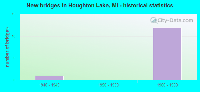
- New bridges - historical statistics
- 11940-1949
- 121960-1969

- Reconstructed bridges - Historical Statistics
- 11980-1989
- 01990-1999
- 12000-2009


- Bridge Condition - Deck
- 28.6%Good
- 42.9%Satisfactory
- 28.6%Fair

- Bridge Condition - Superstructure
- 42.9%Good
- 28.6%Satisfactory
- 28.6%Fair

- Bridge Condition - Substructure
- 42.9%Good
- 28.6%Satisfactory
- 28.6%Fair
Find on map >> Show street view
Structure Number: 9001, Location: 4.5 MI S OF M-55 (Lat: 44.269678, Lng: -84.802575), Route carried "on" structure: County highway , Year Built: 1967, Status: Open, Structure Length: 3.96m (12.99ft), Average Daily Traffic: 130 (year 1988), Truck Traffic: 3%, Average Future Daily Traffic: 70 (year 1977), Design Load: H 15, Features Intersected: US-127 SB, Facility Carried by Structure: SNOW BOWL RD
Minimum Vertical Clearance: 30.48m (100.00ft), Kilometerpoint: 2.759, Lanes on structure: 2, Lanes under structure: 2, Owner: State Highway Agency, Approaching Roadway Width: 10.9m (35.8ft), Skew: 1 degrees, Material/Design: Steel, Design/Construction: Stringer/Multi-beam, Number Of Spans In Main Unit: 3, Length of Maximum Span: 18.2m (59.7ft), Curb-To-Curb Width: 9.1m (29.9ft), Out-to-Out Width: 9.8m (32.2ft)
Condition: Deck: Fair, Superstructure: Satisfactory, Substructure: Satisfactory, Operating Rating: 61.6 metric tons, Method Used To Determine Operating Rating: Load Factor (LF) rating reported by rating factor (RF) method using MS18 loading, Inventory Rating: 28.5 metric tons, Method Used To Determine Inventory Rating: Load Factor (LF) rating reported by rating factor (RF) method using MS18 loading, Structural Evaluation: Equal to present minimum criteria, Deck Geometry: Equal to present minimum criteria, Underclear: Somewhat better than minimum adequacy, Approach Roadway Alignment: Equal to present minimum criteria, Designated Inspection Frequency: Every 24 months, Inspection Date: August 2021, Deck Structure Type: Concrete Cast-file-Place, Wearing Surface/Protective System: Wearing Surface: Epoxy Overlay
Find on map >> Show street view
Structure Number: 9002, Location: 4.5 MI S OF M-55 (Lat: 44.269661, Lng: -84.801381), Route carried "on" structure: County highway , Year Built: 1967, Status: Open, Structure Length: 3.96m (12.99ft), Average Daily Traffic: 130 (year 1988), Truck Traffic: 3%, Average Future Daily Traffic: 70 (year 1977), Design Load: H 15, Features Intersected: US-127 NB, Facility Carried by Structure: SNOW BOWL RD
Minimum Vertical Clearance: 30.48m (100.00ft), Kilometerpoint: 2.853, Lanes on structure: 2, Lanes under structure: 2, Owner: State Highway Agency, Approaching Roadway Width: 10.9m (35.8ft), Skew: 1 degrees, Material/Design: Steel, Design/Construction: Stringer/Multi-beam, Number Of Spans In Main Unit: 3, Length of Maximum Span: 18.2m (59.7ft), Curb-To-Curb Width: 9.1m (29.9ft), Out-to-Out Width: 9.8m (32.2ft)
Condition: Deck: Fair, Superstructure: Fair, Substructure: Good, Operating Rating: 59.0 metric tons, Method Used To Determine Operating Rating: Load Factor (LF) rating reported by rating factor (RF) method using MS18 loading, Inventory Rating: 35.3 metric tons, Method Used To Determine Inventory Rating: Load Factor (LF) rating reported by rating factor (RF) method using MS18 loading, Structural Evaluation: Somewhat better than minimum adequacy, Deck Geometry: Equal to present minimum criteria, Underclear: Somewhat better than minimum adequacy, Approach Roadway Alignment: Better than present minimum criteria, Designated Inspection Frequency: Every 24 months, Inspection Date: August 2021, Deck Structure Type: Concrete Cast-file-Place, Wearing Surface/Protective System: Wearing Surface: Epoxy Overlay
Find on map >> Show street view
Structure Number: 9003, Location: @ M-55 (Lat: 44.335839, Lng: -84.807197), Route carried "on" structure: State highway 55, Year Built: 1961, Year Reconstructed: 2008, Status: Open, Structure Length: 7.01m (23.00ft), Average Daily Traffic: 6,032 (year 2007), Truck Traffic: 6%, Average Future Daily Traffic: 8,250 (year 2028), Design Load: HS 20, Features Intersected: US-127
Minimum Vertical Clearance: 30.48m (100.00ft), Kilometerpoint: 3.758, Lanes on structure: 4, Lanes under structure: 5, Base Highway Network: Yes (Inventory Route: 105, Subroute: 4), Owner: State Highway Agency, Approaching Roadway Width: 18.2m (59.7ft), Material/Design: Steel, Design/Construction: Stringer/Multi-beam, Number Of Spans In Main Unit: 4, Length of Maximum Span: 24.7m (81.0ft), Curb or Sidewalk Widths: Left: 0.7m (2.3ft), Right: 0.7m (2.3ft), Curb-To-Curb Width: 15.2m (49.9ft), Out-to-Out Width: 17.3m (56.8ft)
Condition: Deck: Satisfactory, Superstructure: Good, Substructure: Fair, Operating Rating: 78.1 metric tons, Method Used To Determine Operating Rating: Load Factor (LF) rating reported by rating factor (RF) method using MS18 loading, Inventory Rating: 46.7 metric tons, Method Used To Determine Inventory Rating: Load Factor (LF) rating reported by rating factor (RF) method using MS18 loading, Structural Evaluation: Somewhat better than minimum adequacy, Deck Geometry: High priority of corrective action, Underclear: Meets minimum limits, Approach Roadway Alignment: Equal to present minimum criteria, Designated Inspection Frequency: Every 24 months, Inspection Date: August 2021, Deck Structure Type: Concrete Cast-file-Place, Wearing Surface/Protective System: Wearing Surface: Epoxy Overlay
Find on map >> Show street view
Structure Number: 9006, Location: 2.5 MI N OF M-55 (Lat: 44.371703, Lng: -84.807853), Route carried "on" structure: County highway , Year Built: 1967, Status: Open, Structure Length: 6.25m (20.51ft), Average Daily Traffic: 850 (year 1988), Truck Traffic: 2%, Average Future Daily Traffic: 730 (year 2008), Design Load: H 15, Features Intersected: US-127, Facility Carried by Structure: COUNTY ROAD 300
Minimum Vertical Clearance: 30.48m (100.00ft), Kilometerpoint: 2.039, Lanes on structure: 2, Lanes under structure: 4, Owner: State Highway Agency, Approaching Roadway Width: 10.0m (32.8ft), Material/Design: Prestressed concrete, Design/Construction: Stringer/Multi-beam, Number Of Spans In Main Unit: 4, Length of Maximum Span: 21.6m (70.9ft), Curb-To-Curb Width: 8.7m (28.5ft), Out-to-Out Width: 9.9m (32.5ft)
Condition: Deck: Satisfactory, Superstructure: Fair, Substructure: Good, Operating Rating: 51.2 metric tons, Method Used To Determine Operating Rating: Load Factor (LF) rating reported by rating factor (RF) method using MS18 loading, Inventory Rating: 30.8 metric tons, Method Used To Determine Inventory Rating: Load Factor (LF) rating reported by rating factor (RF) method using MS18 loading, Structural Evaluation: Somewhat better than minimum adequacy, Deck Geometry: Somewhat better than minimum adequacy, Underclear: Somewhat better than minimum adequacy, Approach Roadway Alignment: Better than present minimum criteria, Designated Inspection Frequency: Every 24 months, Inspection Date: August 2021, Deck Structure Type: Concrete Cast-file-Place, Wearing Surface/Protective System: Wearing Surface: Epoxy Overlay
Find on map >> Show street view
Structure Number: 9007, Location: 4.7 MI N OF M-55 (Lat: 44.402978, Lng: -84.799383), Route carried "on" structure: County highway , Year Built: 1967, Status: Open, Structure Length: 3.78m (12.40ft), Average Daily Traffic: 60 (year 1988), Average Future Daily Traffic: 40 (year 1977), Design Load: H 15, Features Intersected: US-127 SB, Facility Carried by Structure: MEADS LANDING RD
Minimum Vertical Clearance: 30.48m (100.00ft), Kilometerpoint: 0.455, Lanes on structure: 2, Lanes under structure: 2, Owner: State Highway Agency, Approaching Roadway Width: 10.9m (35.8ft), Material/Design: Prestressed concrete, Design/Construction: Stringer/Multi-beam, Number Of Spans In Main Unit: 3, Length of Maximum Span: 18.2m (59.7ft), Curb or Sidewalk Widths: Left: 0.2m (0.7ft), Right: 0.2m (0.7ft), Curb-To-Curb Width: 9.1m (29.9ft), Out-to-Out Width: 9.8m (32.2ft)
Condition: Deck: Good, Superstructure: Satisfactory, Substructure: Satisfactory, Operating Rating: 47.3 metric tons, Method Used To Determine Operating Rating: Load Factor (LF) rating reported by rating factor (RF) method using MS18 loading, Inventory Rating: 28.2 metric tons, Method Used To Determine Inventory Rating: Load Factor (LF) rating reported by rating factor (RF) method using MS18 loading, Structural Evaluation: Equal to present minimum criteria, Deck Geometry: Better than present minimum criteria, Underclear: Somewhat better than minimum adequacy, Approach Roadway Alignment: Equal to present minimum criteria, Designated Inspection Frequency: Every 24 months, Inspection Date: August 2021, Deck Structure Type: Concrete Cast-file-Place, Wearing Surface/Protective System: Wearing Surface: Epoxy Overlay
Find on map >> Show street view
Structure Number: 9008, Location: 4.7 MI N OF M-55 (Lat: 44.402697, Lng: -84.798289), Route carried "on" structure: County highway , Year Built: 1967, Status: Open, Structure Length: 3.78m (12.40ft), Average Daily Traffic: 60 (year 1988), Average Future Daily Traffic: 40 (year 1977), Design Load: H 15, Features Intersected: US-127 NB, Facility Carried by Structure: MEADS LANDING RD
Minimum Vertical Clearance: 30.48m (100.00ft), Kilometerpoint: 0.549, Lanes on structure: 2, Lanes under structure: 2, Owner: State Highway Agency, Approaching Roadway Width: 10.9m (35.8ft), Material/Design: Prestressed concrete, Design/Construction: Stringer/Multi-beam, Number Of Spans In Main Unit: 3, Length of Maximum Span: 18.2m (59.7ft), Curb or Sidewalk Widths: Left: 0.2m (0.7ft), Right: 0.2m (0.7ft), Curb-To-Curb Width: 9.1m (29.9ft), Out-to-Out Width: 9.8m (32.2ft)
Condition: Deck: Good, Superstructure: Good, Substructure: Good, Operating Rating: 47.6 metric tons, Method Used To Determine Operating Rating: Load Factor (LF) rating reported by rating factor (RF) method using MS18 loading, Inventory Rating: 28.2 metric tons, Method Used To Determine Inventory Rating: Load Factor (LF) rating reported by rating factor (RF) method using MS18 loading, Structural Evaluation: Better than present minimum criteria, Deck Geometry: Better than present minimum criteria, Underclear: Equal to present minimum criteria, Approach Roadway Alignment: Equal to present desirable criteria, Designated Inspection Frequency: Every 24 months, Inspection Date: August 2021, Deck Structure Type: Concrete Cast-file-Place, Wearing Surface/Protective System: Wearing Surface: Epoxy Overlay
Find on map >> Show street view
Structure Number: 9032, Location: SECTION 10 T23N R4W (Lat: 44.404294, Lng: -84.790811), Route carried "on" structure: Alternate County highway 7213, Year Built: 1947, Year Reconstructed: 1985, Status: Open, Structure Length: 4.11m (13.48ft), Average Daily Traffic: 4,802 (year 2016), Truck Traffic: 5%, Average Future Daily Traffic: 7,105 (year 2036), Design Load: HS 20, Features Intersected: MUSKEGON RIVER, Facility Carried by Structure: OLD US-27
Minimum Vertical Clearance: 30.48m (100.00ft), Kilometerpoint: 30.691, Lanes on structure: 2, Base Highway Network: Yes (Inventory Route: 318, Subroute: 82), Owner: County Highway Agency, Approaching Roadway Width: 14.6m (47.9ft), Material/Design: Steel, Design/Construction: Stringer/Multi-beam, Number Of Spans In Main Unit: 3, Length of Maximum Span: 13.7m (44.9ft), Curb-To-Curb Width: 13.9m (45.6ft), Out-to-Out Width: 14.9m (48.9ft)
Condition: Deck: Satisfactory, Superstructure: Good, Substructure: Fair, Channel: Satisfactory, Operating Rating: 50.5 metric tons, Method Used To Determine Operating Rating: Load Factor (LF) rating reported by rating factor (RF) method using MS18 loading, Inventory Rating: 30.1 metric tons, Method Used To Determine Inventory Rating: Load Factor (LF) rating reported by rating factor (RF) method using MS18 loading, Structural Evaluation: Somewhat better than minimum adequacy, Deck Geometry: Superior to present desirable criteria, Waterway Adequacy: Better than present minimum criteria, Approach Roadway Alignment: Better than present minimum criteria, Designated Inspection Frequency: Every 24 months, Inspection Date: June 2020, Deck Structure Type: Concrete Cast-file-Place, Wearing Surface/Protective System: Wearing Surface: Epoxy Overlay, Deck Protection: Epoxy Coated Reinforcing
Find on map >> Show street view
Structure Number: 9001, Location: 4.5 MI S OF M-55 (Lat: 44.269678, Lng: -84.802575), Route carried "under" structure: US 127, Year Built: 1967, Structure Length: 0. m, Average Daily Traffic: 4,431 (year 2007), Truck Traffic: 11%, Features Intersected: US-127 SB, Facility Carried by Structure: SNOW BOWL RD
Minimum Vertical Clearance: 4.72m (15.49ft), Kilometerpoint: 12.177, Lanes on structure: 2, Lanes under structure: 2, Material/Design: Steel, Design/Construction: Stringer/Multi-beam, Length of Maximum Span: 18.2m (59.7ft)
Find on map >> Show street view
Structure Number: 9002, Location: 4.5 MI S OF M-55 (Lat: 44.269661, Lng: -84.801381), Route carried "under" structure: US 127, Year Built: 1967, Structure Length: 0. m, Average Daily Traffic: 4,431 (year 2007), Truck Traffic: 11%, Features Intersected: US-127 NB, Facility Carried by Structure: SNOW BOWL RD
Minimum Vertical Clearance: 30+ m (98+ ft), Kilometerpoint: 12.177, Lanes on structure: 2, Lanes under structure: 2, Material/Design: Steel, Design/Construction: Stringer/Multi-beam, Length of Maximum Span: 18.2m (59.7ft)
Find on map >> Show street view
Structure Number: 9003, Location: @ M-55 (Lat: 44.335839, Lng: -84.807197), Route carried "under" structure: US 127, Year Built: 1961, Structure Length: 0. m, Average Daily Traffic: 8,268 (year 2007), Truck Traffic: 13%, Features Intersected: US-127, Facility Carried by Structure: M-55
Minimum Vertical Clearance: 4.50m (14.76ft), Kilometerpoint: 19.606, Lanes on structure: 4, Lanes under structure: 5, Material/Design: Steel, Design/Construction: Stringer/Multi-beam, Length of Maximum Span: 24.7m (81.0ft)
Find on map >> Show street view
Structure Number: 9006, Location: 2.5 MI N OF M-55 (Lat: 44.371703, Lng: -84.807853), Route carried "under" structure: US 127, Year Built: 1967, Structure Length: 0. m, Average Daily Traffic: 8,268 (year 2007), Truck Traffic: 13%, Features Intersected: US-127, Facility Carried by Structure: COUNTY ROAD 300
Minimum Vertical Clearance: 4.52m (14.83ft), Kilometerpoint: 23.591, Lanes on structure: 2, Lanes under structure: 4, Material/Design: Prestressed concrete, Design/Construction: Stringer/Multi-beam, Length of Maximum Span: 21.6m (70.9ft)
Find on map >> Show street view
Structure Number: 9007, Location: 4.7 MI N OF M-55 (Lat: 44.402978, Lng: -84.799383), Route carried "under" structure: US 127, Year Built: 1967, Structure Length: 0. m, Average Daily Traffic: 4,134 (year 2007), Truck Traffic: 13%, Features Intersected: US-127 SB, Facility Carried by Structure: MEADS LANDING RD
Minimum Vertical Clearance: 4.50m (14.76ft), Kilometerpoint: 27.170, Lanes on structure: 2, Lanes under structure: 2, Material/Design: Prestressed concrete, Design/Construction: Stringer/Multi-beam, Length of Maximum Span: 18.2m (59.7ft)
Find on map >> Show street view
Structure Number: 9008, Location: 4.7 MI N OF M-55 (Lat: 44.402697, Lng: -84.798289), Route carried "under" structure: US 127, Year Built: 1967, Structure Length: 0. m, Average Daily Traffic: 4,134 (year 2007), Truck Traffic: 13%, Features Intersected: US-127 NB, Facility Carried by Structure: MEADS LANDING RD
Minimum Vertical Clearance: 4.50m (14.76ft), Kilometerpoint: 27.157, Lanes on structure: 2, Lanes under structure: 2, Material/Design: Prestressed concrete, Design/Construction: Stringer/Multi-beam, Length of Maximum Span: 18.2m (59.7ft)