Bridge Statistics for Hoskins, Nebraska (NE)
Condition, Traffic, Stress, Structural Evaluation, Project Costs
- National Bridge Inventory (NBI) Statistics
- 16Number of bridges
- 56ft / 17.2mTotal length
- 3,135Total average daily traffic
- 317Total average daily truck traffic
- 4,785Total future (year 2033) average daily traffic
- National Bridge Inventory (NBI) Registered Bridges for Hoskins
- No street view available for this location
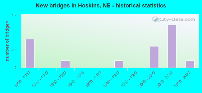
- New bridges - historical statistics
- 41930-1939
- 11950-1959
- 11980-1989
- 32000-2009
- 62010-2019
- 12020-2022

- Bridge Condition - Deck
- 16.7%Very good
- 16.7%Satisfactory
- 50.0%Fair
- 16.7%Poor

- Bridge Condition - Superstructure
- 16.7%Very good
- 33.3%Good
- 16.7%Satisfactory
- 33.3%Fair

- Bridge Condition - Substructure
- 16.7%Very good
- 16.7%Good
- 16.7%Satisfactory
- 33.3%Fair
- 16.7%Serious

- Bridge Condition - Channel
- 12.5%Excellent
- 56.3%Very good
- 12.5%Good
- 18.8%Fair

- Bridge Condition - Culverts
- 50.0%Excellent
- 30.0%Very good
- 10.0%Good
- 10.0%Fair
Find on map >> Show street view
Structure Number: C008420735, Location: 4W 9.7N OF STANTON (Lat: 42.086700, Lng: -97.310000), Route carried "on" structure: County highway 207, Year Built: 2014, Status: Open, Structure Length: 0.95m (3.12ft), Average Daily Traffic: 25 (year 2003), Average Future Daily Traffic: 42 (year 2033), Design Load: HL 93, Features Intersected: STREAM, Facility Carried by Structure: COUNTY HIGHWAY
Minimum Vertical Clearance: 30+ m (98+ ft), Kilometerpoint: 0.000, Lanes on structure: 2, Owner: County Highway Agency, Approaching Roadway Width: 8.5m (27.9ft), Material/Design: Concrete, Design/Construction: Culvert, Number Of Spans In Main Unit: 3, Length of Maximum Span: 3.0m (9.8ft)
Condition: Channel: Very good, Culverts: Very good, Operating Rating: 66.0 metric tons, Method Used To Determine Operating Rating: Load and Resistance Factor (LRFR), Inventory Rating: 51.0 metric tons, Method Used To Determine Inventory Rating: Load and Resistance Factor (LRFR), Structural Evaluation: Equal to present desirable criteria, Waterway Adequacy: Superior to present desirable criteria, Approach Roadway Alignment: Equal to present desirable criteria, Length Of Structure Improvement: 1.22m (4.00ft), Designated Inspection Frequency: Every 24 months, Inspection Date: September 2020
Find on map >> Show street view
Structure Number: C009000305, Location: 2.2W 2.2N OF HOSKINS (Lat: 42.146000, Lng: -97.349200), Route carried "on" structure: County highway 7793, Year Built: 2017, Status: Open, Structure Length: 1.11m (3.64ft), Average Daily Traffic: 60 (year 1998), Average Future Daily Traffic: 102 (year 2033), Features Intersected: STREAM
Minimum Vertical Clearance: 30+ m (98+ ft), Kilometerpoint: 0.460, Lanes on structure: 2, Owner: County Highway Agency, Approaching Roadway Width: 8.5m (27.9ft), Skew: 2 degrees, Material/Design: Steel, Design/Construction: Culvert, Number Of Spans In Main Unit: 3, Length of Maximum Span: 2.7m (8.9ft)
Condition: Channel: Very good, Culverts: Excellent, Operating Rating: 43.0 metric tons, Method Used To Determine Operating Rating: Load and Resistance Factor (LRFR), Inventory Rating: 33.0 metric tons, Method Used To Determine Inventory Rating: Load and Resistance Factor (LRFR), Structural Evaluation: Superior to present desirable criteria, Waterway Adequacy: Equal to present minimum criteria, Approach Roadway Alignment: Equal to present desirable criteria, Length Of Structure Improvement: 1.22m (4.00ft), Designated Inspection Frequency: Every 24 months, Inspection Date: October 2021
Find on map >> Show street view
Structure Number: C00900031, Location: 2.2W 2.5N OF HOSKINS (Lat: 42.148700, Lng: -97.349200), Route carried "on" structure: County highway 7793, Year Built: 2021, Status: Open, Structure Length: 1.23m (4.04ft), Average Daily Traffic: 60 (year 1998), Average Future Daily Traffic: 102 (year 2033), Design Load: HL 93, Features Intersected: TURTLE CREEK, Facility Carried by Structure: 559TH AVE
Minimum Vertical Clearance: 30+ m (98+ ft), Kilometerpoint: 0.491, Lanes on structure: 2, Owner: County Highway Agency, Approaching Roadway Width: 7.3m (24.0ft), Skew: 3 degrees, Material/Design: Steel, Design/Construction: Culvert, Number Of Spans In Main Unit: 3, Length of Maximum Span: 3.3m (10.8ft)
Condition: Channel: Very good, Culverts: Excellent, Operating Rating: 43.0 metric tons, Method Used To Determine Operating Rating: Load Factor (LF), Inventory Rating: 33.0 metric tons, Method Used To Determine Inventory Rating: Load Factor (LF), Structural Evaluation: Superior to present desirable criteria, Waterway Adequacy: Somewhat better than minimum adequacy, Approach Roadway Alignment: Equal to present desirable criteria, Length Of Structure Improvement: 1.22m (4.00ft), Designated Inspection Frequency: Every 24 months, Inspection Date: October 2021
Find on map >> Show street view
Structure Number: C009000505, Location: 1.2S 1W OF HOSKINS (Lat: 42.092200, Lng: -97.329300), Route carried "on" structure: County highway 5, Year Built: 1935, Status: Posted for load, Structure Length: 1.22m (4.00ft), Average Daily Traffic: 25 (year 2003), Average Future Daily Traffic: 42 (year 2033), Features Intersected: STREAM
Minimum Vertical Clearance: 30+ m (98+ ft), Kilometerpoint: 0.000, Lanes on structure: 1, Owner: County Highway Agency, Approaching Roadway Width: 4.9m (16.1ft), Material/Design: Steel, Design/Construction: Girder and Floorbeam System, Number Of Spans In Main Unit: 1, Length of Maximum Span: 11.6m (38.1ft), Curb-To-Curb Width: 4.9m (16.1ft), Out-to-Out Width: 4.9m (16.1ft)
Condition: Deck: Fair, Superstructure: Fair, Substructure: Fair, Channel: Fair, Operating Rating: 23.0 metric tons, Method Used To Determine Operating Rating: Load Factor (LF), Inventory Rating: 14.0 metric tons, Method Used To Determine Inventory Rating: Load Factor (LF), Structural Evaluation: Meets minimum limits, Deck Geometry: High priority of corrective action, Waterway Adequacy: Better than present minimum criteria, Approach Roadway Alignment: Equal to present minimum criteria, Bridge Posting: Required (Relationship of Operating Rating to Maximum Legal Load: > 39.9% below), Length Of Structure Improvement: 1.22m (4.00ft), Designated Inspection Frequency: Every 24 months, Critical Feature Inspection Frequency: Every 24 months, Inspection Date: September 2021, Critical Feature Inspection Date: September 2021, Deck Structure Type: Wood or Timber, Wearing Surface/Protective System: Wearing Surface: Gravel
Find on map >> Show street view
Structure Number: C00900051, Location: 1.7N 1W OF HOSKINS (Lat: 42.143300, Lng: -97.330000), Route carried "on" structure: County highway 5, Year Built: 2012, Status: Open, Structure Length: 1.31m (4.30ft), Average Daily Traffic: 25 (year 2003), Average Future Daily Traffic: 42 (year 2033), Design Load: HS 20, Features Intersected: STREAM
Minimum Vertical Clearance: 30+ m (98+ ft), Kilometerpoint: 0.000, Lanes on structure: 2, Owner: County Highway Agency, Approaching Roadway Width: 8.5m (27.9ft), Skew: 2 degrees, Material/Design: Steel, Design/Construction: Culvert, Number Of Spans In Main Unit: 4, Length of Maximum Span: 2.4m (7.9ft)
Condition: Channel: Very good, Culverts: Excellent, Operating Rating: 42.0 metric tons, Method Used To Determine Operating Rating: Field evaluation and documented engineering judgment, Inventory Rating: 33.0 metric tons, Method Used To Determine Inventory Rating: Field evaluation and documented engineering judgment, Structural Evaluation: Superior to present desirable criteria, Waterway Adequacy: Better than present minimum criteria, Approach Roadway Alignment: Equal to present desirable criteria, Length Of Structure Improvement: 0.98m (3.22ft), Designated Inspection Frequency: Every 24 months, Inspection Date: November 2020
Find on map >> Show street view
Structure Number: C00900091, Location: .6E .6N OF HOSKINS (Lat: 42.120000, Lng: -97.290000), Route carried "on" structure: County highway 9, Year Built: 2004, Status: Open, Structure Length: 1.16m (3.81ft), Average Daily Traffic: 30 (year 2003), Average Future Daily Traffic: 42 (year 2033), Design Load: HS 20, Features Intersected: TRIB. TO SPRING CREEK, Facility Carried by Structure: 562ND AVENUE
Minimum Vertical Clearance: 30+ m (98+ ft), Kilometerpoint: 0.000, Lanes on structure: 2, Owner: County Highway Agency, Approaching Roadway Width: 8.5m (27.9ft), Material/Design: Concrete, Design/Construction: Culvert, Number Of Spans In Main Unit: 3, Length of Maximum Span: 3.7m (12.1ft)
Condition: Channel: Excellent, Culverts: Very good, Operating Rating: 33.0 metric tons, Method Used To Determine Operating Rating: Field evaluation and documented engineering judgment, Inventory Rating: 22.0 metric tons, Method Used To Determine Inventory Rating: Field evaluation and documented engineering judgment, Structural Evaluation: Equal to present minimum criteria, Waterway Adequacy: Equal to present desirable criteria, Approach Roadway Alignment: Equal to present desirable criteria, Length Of Structure Improvement: 0.98m (3.22ft), Designated Inspection Frequency: Every 24 months, Inspection Date: November 2020
Find on map >> Show street view
Structure Number: C009000912, Location: 1NE OF HOSKINS (Lat: 42.121700, Lng: -97.290000), Route carried "on" structure: County highway 9, Year Built: 2013, Status: Open, Structure Length: 1.16m (3.81ft), Average Daily Traffic: 30 (year 2003), Average Future Daily Traffic: 51 (year 2033), Design Load: HL 93, Features Intersected: STREAM, Facility Carried by Structure: 562ND AVENUE
Minimum Vertical Clearance: 30+ m (98+ ft), Kilometerpoint: 0.000, Lanes on structure: 2, Owner: County Highway Agency, Approaching Roadway Width: 8.5m (27.9ft), Skew: 3 degrees, Material/Design: Concrete, Design/Construction: Culvert, Number Of Spans In Main Unit: 3, Length of Maximum Span: 3.0m (9.8ft)
Condition: Channel: Very good, Culverts: Very good, Operating Rating: 42.0 metric tons, Method Used To Determine Operating Rating: Load and Resistance Factor (LRFR), Inventory Rating: 33.0 metric tons, Method Used To Determine Inventory Rating: Load and Resistance Factor (LRFR), Structural Evaluation: Equal to present desirable criteria, Waterway Adequacy: Better than present minimum criteria, Approach Roadway Alignment: Equal to present desirable criteria, Length Of Structure Improvement: 1.01m (3.31ft), Designated Inspection Frequency: Every 24 months, Inspection Date: October 2021
Find on map >> Show street view
Structure Number: C009000913, Location: JCT N57/N98 5W 6.5S (Lat: 42.141500, Lng: -97.290700), Route carried "on" structure: County highway 3215, Year Built: 2017, Status: Open, Structure Length: 1.03m (3.38ft), Average Daily Traffic: 130 (year 2011), Average Future Daily Traffic: 130 (year 2033), Design Load: HL 93, Features Intersected: STREAM, Facility Carried by Structure: 562ND AVE
Minimum Vertical Clearance: 30+ m (98+ ft), Kilometerpoint: 0.452, Lanes on structure: 2, Owner: County Highway Agency, Approaching Roadway Width: 8.5m (27.9ft), Skew: 2 degrees, Material/Design: Concrete, Design/Construction: Culvert, Number Of Spans In Main Unit: 3, Length of Maximum Span: 3.2m (10.5ft)
Condition: Channel: Very good, Culverts: Excellent, Operating Rating: 58.0 metric tons, Method Used To Determine Operating Rating: Load and Resistance Factor (LRFR), Inventory Rating: 44.0 metric tons, Method Used To Determine Inventory Rating: Load and Resistance Factor (LRFR), Structural Evaluation: Superior to present desirable criteria, Waterway Adequacy: Better than present minimum criteria, Approach Roadway Alignment: Equal to present desirable criteria, Length Of Structure Improvement: 0.67m (2.20ft), Designated Inspection Frequency: Every 24 months, Inspection Date: November 2020
Find on map >> Show street view
Structure Number: C009001105, Location: 4.5W 2.5S OF WINSIDE (Lat: 42.140000, Lng: -97.271700), Route carried "on" structure: County highway 11, Year Built: 2005, Status: Open, Structure Length: 1.28m (4.20ft), Average Daily Traffic: 30 (year 2003), Average Future Daily Traffic: 51 (year 2033), Features Intersected: HUMBUG CREEK, Facility Carried by Structure: 563RD AVENUE
Minimum Vertical Clearance: 30+ m (98+ ft), Kilometerpoint: 0.000, Lanes on structure: 2, Owner: County Highway Agency, Approaching Roadway Width: 7.3m (24.0ft), Skew: 3 degrees, Material/Design: Steel, Design/Construction: Stringer/Multi-beam, Number Of Spans In Main Unit: 1, Length of Maximum Span: 12.2m (40.0ft), Curb-To-Curb Width: 8.5m (27.9ft), Out-to-Out Width: 8.7m (28.5ft)
Condition: Deck: Very good, Superstructure: Very good, Substructure: Very good, Channel: Very good, Operating Rating: 73.0 metric tons, Method Used To Determine Operating Rating: Load Factor (LF), Inventory Rating: 44.0 metric tons, Method Used To Determine Inventory Rating: Load Factor (LF), Structural Evaluation: Equal to present desirable criteria, Deck Geometry: Better than present minimum criteria, Waterway Adequacy: Better than present minimum criteria, Approach Roadway Alignment: Equal to present desirable criteria, Length Of Structure Improvement: 0.91m (2.99ft), Designated Inspection Frequency: Every 24 months, Inspection Date: October 2021, Deck Structure Type: Concrete Cast-file-Place, Wearing Surface/Protective System: Wearing Surface: Monolithic Concrete
Find on map >> Show street view
Structure Number: C00900281, Location: 3.2N 1.8W OF HOSKINS (Lat: 42.163100, Lng: -97.345500), Route carried "on" structure: County highway 28, Year Built: 1935, Status: Posted for load, Structure Length: 1.10m (3.61ft), Average Daily Traffic: 20 (year 2003), Average Future Daily Traffic: 34 (year 2033), Features Intersected: STREAM, Facility Carried by Structure: 851ST ROAD
Minimum Vertical Clearance: 30+ m (98+ ft), Kilometerpoint: 0.000, Lanes on structure: 2, Owner: County Highway Agency, Approaching Roadway Width: 5.2m (17.1ft), Material/Design: Steel, Design/Construction: Girder and Floorbeam System, Number Of Spans In Main Unit: 1, Length of Maximum Span: 10.7m (35.1ft), Curb-To-Curb Width: 5.7m (18.7ft), Out-to-Out Width: 6.0m (19.7ft)
Condition: Deck: Poor, Superstructure: Satisfactory, Substructure: Fair, Channel: Fair, Operating Rating: 17.0 metric tons, Method Used To Determine Operating Rating: Load Factor (LF), Inventory Rating: 10.0 metric tons, Method Used To Determine Inventory Rating: Load Factor (LF), Structural Evaluation: High priority of replacement, Deck Geometry: Meets minimum limits, Waterway Adequacy: Better than present minimum criteria, Approach Roadway Alignment: Equal to present minimum criteria, Bridge Posting: Required (Relationship of Operating Rating to Maximum Legal Load: > 39.9% below), Length Of Structure Improvement: 1.10m (3.61ft), Designated Inspection Frequency: Every 24 months, Critical Feature Inspection Frequency: Every 24 months, Inspection Date: September 2021, Critical Feature Inspection Date: September 2021, Deck Structure Type: Wood or Timber, Wearing Surface/Protective System: Wearing Surface: Gravel
Find on map >> Show street view
Structure Number: C009002815, Location: .6S 6.1W OF WINSIDE (Lat: 42.163300, Lng: -97.291700), Route carried "on" structure: County highway 28, Year Built: 2011, Status: Open, Structure Length: 0.79m (2.59ft), Average Daily Traffic: 10 (year 2003), Average Future Daily Traffic: 17 (year 2033), Design Load: HS 20, Features Intersected: STREAM, Facility Carried by Structure: 851ST ROAD
Minimum Vertical Clearance: 30+ m (98+ ft), Kilometerpoint: 0.000, Lanes on structure: 2, Owner: County Highway Agency, Approaching Roadway Width: 7.3m (24.0ft), Material/Design: Concrete, Design/Construction: Culvert, Number Of Spans In Main Unit: 3, Length of Maximum Span: 2.4m (7.9ft)
Condition: Channel: Excellent, Culverts: Excellent, Operating Rating: 42.0 metric tons, Method Used To Determine Operating Rating: Field evaluation and documented engineering judgment, Inventory Rating: 33.0 metric tons, Method Used To Determine Inventory Rating: Field evaluation and documented engineering judgment, Structural Evaluation: Superior to present desirable criteria, Waterway Adequacy: Somewhat better than minimum adequacy, Approach Roadway Alignment: Better than present minimum criteria, Length Of Structure Improvement: 0.98m (3.22ft), Designated Inspection Frequency: Every 24 months, Inspection Date: October 2021
Find on map >> Show street view
Structure Number: C009003005, Location: 2.2N .7W OF HOSKINS (Lat: 42.148300, Lng: -97.325000), Route carried "on" structure: County highway 30, Year Built: 2000, Status: Open, Structure Length: 0.64m (2.10ft), Average Daily Traffic: 15 (year 2003), Average Future Daily Traffic: 21 (year 2033), Design Load: HS 20, Features Intersected: STREAM, Facility Carried by Structure: 850TH ROAD
Minimum Vertical Clearance: 30+ m (98+ ft), Kilometerpoint: 0.000, Lanes on structure: 2, Owner: County Highway Agency, Approaching Roadway Width: 6.7m (22.0ft), Skew: 2 degrees, Material/Design: Steel, Design/Construction: Culvert, Number Of Spans In Main Unit: 2, Length of Maximum Span: 2.7m (8.9ft)
Condition: Channel: Very good, Culverts: Fair, Operating Rating: 38.0 metric tons, Method Used To Determine Operating Rating: Field evaluation and documented engineering judgment, Inventory Rating: 33.0 metric tons, Method Used To Determine Inventory Rating: Field evaluation and documented engineering judgment, Structural Evaluation: Somewhat better than minimum adequacy, Waterway Adequacy: Equal to present desirable criteria, Approach Roadway Alignment: Equal to present desirable criteria, Length Of Structure Improvement: 0.98m (3.22ft), Designated Inspection Frequency: Every 24 months, Inspection Date: November 2020
Find on map >> Show street view
Structure Number: C00900301, Location: 2.2N .5E OF HOSKINS (Lat: 42.148700, Lng: -97.290800), Route carried "on" structure: County highway 30, Year Built: 1935, Status: Posted for load, Structure Length: 0.67m (2.20ft), Average Daily Traffic: 10 (year 2003), Average Future Daily Traffic: 17 (year 2033), Features Intersected: STREAM, Facility Carried by Structure: 850TH ROAD
Minimum Vertical Clearance: 30+ m (98+ ft), Kilometerpoint: 0.000, Lanes on structure: 2, Owner: County Highway Agency, Approaching Roadway Width: 6.7m (22.0ft), Material/Design: Wood or Timber, Design/Construction: Stringer/Multi-beam, Number Of Spans In Main Unit: 1, Length of Maximum Span: 6.4m (21.0ft), Curb-To-Curb Width: 5.8m (19.0ft), Out-to-Out Width: 6.2m (20.3ft)
Condition: Deck: Fair, Superstructure: Fair, Substructure: Serious, Channel: Good, Operating Rating: 11.0 metric tons, Method Used To Determine Operating Rating: Allowable Stress (AS), Inventory Rating: 6.0 metric tons, Method Used To Determine Inventory Rating: Allowable Stress (AS), Structural Evaluation: High priority of replacement, Deck Geometry: Meets minimum limits, Waterway Adequacy: Somewhat better than minimum adequacy, Approach Roadway Alignment: Equal to present minimum criteria, Bridge Posting: Required (Relationship of Operating Rating to Maximum Legal Load: > 39.9% below), Length Of Structure Improvement: 0.67m (2.20ft), Designated Inspection Frequency: Every 24 months, Other Special Inspection Frequency: Every 24 months, Inspection Date: November 2021, Other Special Inspection Date: November 2021, Deck Structure Type: Wood or Timber, Wearing Surface/Protective System: Wearing Surface: Wood or Timber
Find on map >> Show street view
Structure Number: C009003015, Location: 1.6S 4.1W OF WINSIDE (Lat: 42.148400, Lng: -97.251800), Route carried "on" structure: County highway 30, Year Built: 1935, Status: Posted for load, Structure Length: 0.91m (2.99ft), Average Daily Traffic: 40 (year 2003), Average Future Daily Traffic: 68 (year 2033), Features Intersected: STREAM, Facility Carried by Structure: 850TH ROAD
Minimum Vertical Clearance: 30+ m (98+ ft), Kilometerpoint: 0.000, Lanes on structure: 1, Owner: County Highway Agency, Approaching Roadway Width: 6.1m (20.0ft), Material/Design: Steel, Design/Construction: Stringer/Multi-beam, Number Of Spans In Main Unit: 1, Length of Maximum Span: 8.8m (28.9ft), Curb or Sidewalk Widths: Left: 0.2m (0.7ft), Right: 0.2m (0.7ft), Curb-To-Curb Width: 4.6m (15.1ft), Out-to-Out Width: 4.9m (16.1ft)
Condition: Deck: Fair, Superstructure: Good, Substructure: Satisfactory, Channel: Fair, Operating Rating: 18.0 metric tons, Method Used To Determine Operating Rating: Load Factor (LF), Inventory Rating: 11.0 metric tons, Method Used To Determine Inventory Rating: Load Factor (LF), Structural Evaluation: Meets minimum limits, Deck Geometry: Better than present minimum criteria, Waterway Adequacy: Meets minimum limits, Approach Roadway Alignment: Equal to present minimum criteria, Bridge Posting: Required (Relationship of Operating Rating to Maximum Legal Load: > 39.9% below), Length Of Structure Improvement: 0.91m (2.99ft), Designated Inspection Frequency: Every 24 months, Inspection Date: November 2021, Deck Structure Type: Wood or Timber, Wearing Surface/Protective System: Wearing Surface: Wood or Timber
Find on map >> Show street view
Structure Number: M1245B0705, Location: HOSKINS MAIN @ 1ST (Lat: 42.115300, Lng: -97.306400), Route carried "on" structure: City street 3215, Year Built: 1981, Status: Open, Structure Length: 2.04m (6.69ft), Average Daily Traffic: 185 (year 2011), Average Future Daily Traffic: 120 (year 2033), Design Load: HS 20, Features Intersected: STREAM
Minimum Vertical Clearance: 30+ m (98+ ft), Kilometerpoint: 0.074, Lanes on structure: 2, Owner: City or Municipal Highway Agency, Approaching Roadway Width: 11.0m (36.1ft), Material/Design: Concrete continuous, Design/Construction: Slab, Number Of Spans In Main Unit: 3, Length of Maximum Span: 7.9m (25.9ft), Curb or Sidewalk Widths: Left: 1.6m (5.2ft), Right: 0.2m (0.7ft), Curb-To-Curb Width: 11.0m (36.1ft), Out-to-Out Width: 13.0m (42.7ft)
Condition: Deck: Satisfactory, Superstructure: Good, Substructure: Good, Channel: Very good, Operating Rating: 57.0 metric tons, Method Used To Determine Operating Rating: Load Factor (LF), Inventory Rating: 34.0 metric tons, Method Used To Determine Inventory Rating: Load Factor (LF), Structural Evaluation: Better than present minimum criteria, Deck Geometry: Equal to present desirable criteria, Waterway Adequacy: Equal to present desirable criteria, Approach Roadway Alignment: Better than present minimum criteria, Designated Inspection Frequency: Every 24 months, Inspection Date: November 2020, Deck Structure Type: Concrete Cast-file-Place, Wearing Surface/Protective System: Wearing Surface: Monolithic Concrete
Find on map >> Show street view
Structure Number: S035 00869, Location: 2E HOSKINS (Lat: 42.105200, Lng: -97.268200), Route carried "on" structure: State highway 35, Year Built: 1955, Year Reconstructed: 2000, Status: Open, Structure Length: 0.64m (2.10ft), Average Daily Traffic: 2,440 (year 2018), Truck Traffic: 13%, Average Future Daily Traffic: 3,904 (year 2038), Design Load: HS 20, Features Intersected: STREAM
Minimum Vertical Clearance: 30+ m (98+ ft), Kilometerpoint: 1.399, Lanes on structure: 2, Base Highway Network: Yes, Owner: State Highway Agency, Approaching Roadway Width: 7.3m (24.0ft), Material/Design: Concrete, Design/Construction: Culvert, Number Of Spans In Main Unit: 2, Length of Maximum Span: 3.0m (9.8ft)
Condition: Channel: Good, Culverts: Good, Operating Rating: 33.0 metric tons, Method Used To Determine Operating Rating: Field evaluation and documented engineering judgment, Inventory Rating: 22.0 metric tons, Method Used To Determine Inventory Rating: Field evaluation and documented engineering judgment, Structural Evaluation: Somewhat better than minimum adequacy, Waterway Adequacy: Better than present minimum criteria, Approach Roadway Alignment: Equal to present desirable criteria, Designated Inspection Frequency: Every 24 months, Inspection Date: October 2020