Bridge Statistics for Hopwood, Pennsylvania (PA)
Condition, Traffic, Stress, Structural Evaluation, Project Costs
- National Bridge Inventory (NBI) Statistics
- 18Number of bridges
- 108ft / 32.6mTotal length
- $251,000Total costs
- 73,288Total average daily traffic
- 8,424Total average daily truck traffic
- National Bridge Inventory (NBI) Registered Bridges for Hopwood
- No street view available for this location
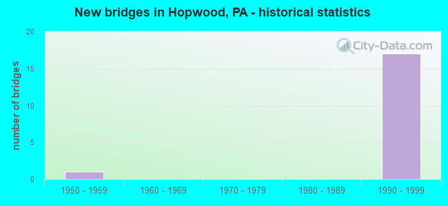
- New bridges - historical statistics
- 11950-1959
- 171990-1999


- Bridge Condition - Superstructure
- 11.1%Very good
- 88.9%Good

- Bridge Condition - Substructure
- 66.7%Good
- 33.3%Satisfactory
Find on map >> Show street view
Structure Number: 16567, Location: SOUTH UNION TOWNSHIP (Lat: 39.870111, Lng: -79.716667), Route carried "on" structure: Bypass US 40, Year Built: 1993, Status: Open, Structure Length: 0.67m (2.20ft), Average Daily Traffic: 10,269 (year 2021), Truck Traffic: 13%, Average Future Daily Traffic: 8,791 (year 2032), Design Load: HS 25 or greater, Features Intersected: REDSTONE CREEK
Minimum Vertical Clearance: 30+ m (98+ ft), Kilometerpoint: 24.903, Lanes on structure: 4, Base Highway Network: Yes, Owner: State Highway Agency, Approaching Roadway Width: 36.6m (120.1ft), Skew: 21 degrees, Material/Design: Concrete, Design/Construction: Culvert, Number Of Spans In Main Unit: 2, Length of Maximum Span: 3.0m (9.8ft)
Condition: Channel: Satisfactory, Culverts: Satisfactory, Inventory Rating: 99.8 metric tons, Method Used To Determine Inventory Rating: Load Factor (LF), Structural Evaluation: Equal to present minimum criteria, Waterway Adequacy: Superior to present desirable criteria, Approach Roadway Alignment: Equal to present desirable criteria, Length Of Structure Improvement: 1.30m (4.27ft), Designated Inspection Frequency: Every 48 months, Inspection Date: November 2018
Find on map >> Show street view
Structure Number: 16568, Location: SOUTH UNION TOWNSHIP (Lat: 39.870628, Lng: -79.715214), Route carried "on" structure: Bypass US 40, Year Built: 1993, Status: Open, Structure Length: 4.57m (14.99ft), Average Daily Traffic: 5,100 (year 2021), Truck Traffic: 13%, Average Future Daily Traffic: 4,608 (year 2032), Design Load: HS 20+Mod, Features Intersected: STADIUM DRIVE
Minimum Vertical Clearance: 30+ m (98+ ft), Kilometerpoint: 25.862, Lanes on structure: 2, Lanes under structure: 2, Base Highway Network: Yes, Owner: State Highway Agency, Approaching Roadway Width: 12.8m (42.0ft), Skew: 14 degrees, Material/Design: Prestressed concrete, Design/Construction: Stringer/Multi-beam, Number Of Spans In Main Unit: 1, Length of Maximum Span: 45.7m (149.9ft), Curb or Sidewalk Widths: Left: 0.2m (0.7ft), Right: 0.2m (0.7ft), Curb-To-Curb Width: 12.2m (40.0ft), Out-to-Out Width: 13.3m (43.6ft)
Condition: Deck: Good, Superstructure: Good, Substructure: Good, Inventory Rating: 50.8 metric tons, Method Used To Determine Inventory Rating: Load Factor (LF), Structural Evaluation: Better than present minimum criteria, Deck Geometry: Better than present minimum criteria, Underclear: Superior to present desirable criteria, Approach Roadway Alignment: Equal to present desirable criteria, Length Of Structure Improvement: 5.50m (18.04ft), Designated Inspection Frequency: Every 48 months, Inspection Date: November 2020, Deck Structure Type: Concrete Cast-file-Place, Wearing Surface/Protective System: Wearing Surface: Monolithic Concrete, Deck Protection: Epoxy Coated Reinforcing
Find on map >> Show street view
Structure Number: 16569, Location: SOUTH UNION TOWNSHIP (Lat: 39.871453, Lng: -79.712689), Route carried "on" structure: Bypass US 40, Year Built: 1993, Status: Open, Structure Length: 3.35m (10.99ft), Average Daily Traffic: 5,100 (year 2021), Truck Traffic: 13%, Average Future Daily Traffic: 4,608 (year 2032), Design Load: HS 20+Mod, Features Intersected: Southwest PA Railroad
Minimum Vertical Clearance: 30+ m (98+ ft), Kilometerpoint: 25.862, Lanes on structure: 2, Base Highway Network: Yes, Owner: State Highway Agency, Approaching Roadway Width: 12.8m (42.0ft), Skew: 11 degrees, Material/Design: Prestressed concrete, Design/Construction: Box Beam or Girders - Multiple, Number Of Spans In Main Unit: 1, Length of Maximum Span: 33.5m (109.9ft), Curb or Sidewalk Widths: Left: 0.2m (0.7ft), Right: 0.2m (0.7ft), Curb-To-Curb Width: 12.6m (41.3ft), Out-to-Out Width: 13.7m (44.9ft)
Condition: Deck: Good, Superstructure: Good, Substructure: Good, Inventory Rating: 55.3 metric tons, Method Used To Determine Inventory Rating: Load Factor (LF), Structural Evaluation: Better than present minimum criteria, Deck Geometry: Better than present minimum criteria, Underclear: High priority of corrective action, Approach Roadway Alignment: Equal to present desirable criteria, Length Of Structure Improvement: 4.20m (13.78ft), Designated Inspection Frequency: Every 48 months, Inspection Date: November 2020, Deck Structure Type: Concrete Cast-file-Place, Wearing Surface/Protective System: Wearing Surface: Monolithic Concrete, Deck Protection: Epoxy Coated Reinforcing
Find on map >> Show street view
Structure Number: 1657, Location: SOUTH UNION TOWNSHIP (Lat: 39.872469, Lng: -79.708803), Route carried "on" structure: Bypass US 40, Year Built: 1993, Status: Open, Structure Length: 3.96m (12.99ft), Average Daily Traffic: 5,100 (year 2021), Truck Traffic: 13%, Average Future Daily Traffic: 4,608 (year 2032), Design Load: HS 25 or greater, Features Intersected: SR 2025
Minimum Vertical Clearance: 30+ m (98+ ft), Kilometerpoint: 25.862, Lanes on structure: 4, Lanes under structure: 2, Base Highway Network: Yes, Owner: State Highway Agency, Approaching Roadway Width: 14.6m (47.9ft), Skew: 14 degrees, Material/Design: Prestressed concrete, Design/Construction: Stringer/Multi-beam, Number Of Spans In Main Unit: 1, Length of Maximum Span: 38.7m (127.0ft), Curb or Sidewalk Widths: Left: 0.2m (0.7ft), Right: 0.2m (0.7ft), Curb-To-Curb Width: 24.4m (80.1ft), Out-to-Out Width: 26.5m (86.9ft)
Condition: Deck: Good, Superstructure: Good, Substructure: Good, Inventory Rating: 49.9 metric tons, Method Used To Determine Inventory Rating: Load Factor (LF), Structural Evaluation: Better than present minimum criteria, Deck Geometry: Superior to present desirable criteria, Underclear: High priority of corrective action, Approach Roadway Alignment: Equal to present desirable criteria, Length Of Structure Improvement: 4.80m (15.75ft), Designated Inspection Frequency: Every 48 months, Inspection Date: November 2020, Deck Structure Type: Concrete Cast-file-Place, Wearing Surface/Protective System: Wearing Surface: Monolithic Concrete, Deck Protection: Epoxy Coated Reinforcing
Find on map >> Show street view
Structure Number: 16571, Location: SOUTH UNION TOWNSHIP (Lat: 39.870875, Lng: -79.715083), Route carried "on" structure: Bypass US 40, Year Built: 1993, Status: Open, Structure Length: 4.82m (15.81ft), Average Daily Traffic: 5,169 (year 2021), Truck Traffic: 13%, Average Future Daily Traffic: 4,183 (year 2032), Design Load: HS 25 or greater, Features Intersected: STADIUM DRIVE
Minimum Vertical Clearance: 30+ m (98+ ft), Kilometerpoint: 25.798, Lanes on structure: 2, Lanes under structure: 2, Base Highway Network: Yes, Owner: State Highway Agency, Approaching Roadway Width: 12.8m (42.0ft), Skew: 14 degrees, Material/Design: Prestressed concrete, Design/Construction: Stringer/Multi-beam, Number Of Spans In Main Unit: 1, Length of Maximum Span: 45.7m (149.9ft), Curb or Sidewalk Widths: Left: 0.2m (0.7ft), Right: 0.2m (0.7ft), Curb-To-Curb Width: 12.2m (40.0ft), Out-to-Out Width: 13.3m (43.6ft)
Condition: Deck: Good, Superstructure: Good, Substructure: Good, Inventory Rating: 50.8 metric tons, Method Used To Determine Inventory Rating: Load Factor (LF), Structural Evaluation: Better than present minimum criteria, Deck Geometry: Better than present minimum criteria, Underclear: Superior to present desirable criteria, Approach Roadway Alignment: Equal to present desirable criteria, Length Of Structure Improvement: 5.70m (18.70ft), Designated Inspection Frequency: Every 48 months, Inspection Date: November 2020, Deck Structure Type: Concrete Cast-file-Place, Wearing Surface/Protective System: Wearing Surface: Monolithic Concrete, Deck Protection: Epoxy Coated Reinforcing
Find on map >> Show street view
Structure Number: 16573, Location: SOUTH UNION TOWNSHIP (Lat: 39.871639, Lng: -79.712750), Route carried "on" structure: Bypass US 40, Year Built: 1993, Status: Open, Structure Length: 3.35m (10.99ft), Average Daily Traffic: 5,169 (year 2021), Truck Traffic: 13%, Average Future Daily Traffic: 4,183 (year 2032), Design Load: HS 20+Mod, Features Intersected: Southwest PA Railroad
Minimum Vertical Clearance: 30+ m (98+ ft), Kilometerpoint: 25.798, Lanes on structure: 2, Base Highway Network: Yes, Owner: State Highway Agency, Approaching Roadway Width: 12.2m (40.0ft), Skew: 11 degrees, Material/Design: Prestressed concrete, Design/Construction: Box Beam or Girders - Multiple, Number Of Spans In Main Unit: 1, Length of Maximum Span: 33.5m (109.9ft), Curb or Sidewalk Widths: Left: 0.2m (0.7ft), Right: 0.2m (0.7ft), Curb-To-Curb Width: 12.6m (41.3ft), Out-to-Out Width: 13.7m (44.9ft)
Condition: Deck: Good, Superstructure: Good, Substructure: Good, Inventory Rating: 55.3 metric tons, Method Used To Determine Inventory Rating: Load Factor (LF), Structural Evaluation: Better than present minimum criteria, Deck Geometry: Better than present minimum criteria, Underclear: High priority of corrective action, Approach Roadway Alignment: Equal to present desirable criteria, Length Of Structure Improvement: 4.20m (13.78ft), Designated Inspection Frequency: Every 48 months, Inspection Date: November 2020, Deck Structure Type: Concrete Cast-file-Place, Wearing Surface/Protective System: Wearing Surface: Monolithic Concrete, Deck Protection: Epoxy Coated Reinforcing
Find on map >> Show street view
Structure Number: 16574, Location: SOUTH UNION TOWNSHIP (Lat: 39.876000, Lng: -79.713953), Route carried "on" structure: Bypass US 40, Year Built: 1993, Status: Open, Structure Length: 3.96m (12.99ft), Average Daily Traffic: 5,169 (year 2021), Truck Traffic: 13%, Average Future Daily Traffic: 4,183 (year 2032), Design Load: HS 25 or greater, Features Intersected: SR 2025
Minimum Vertical Clearance: 30+ m (98+ ft), Kilometerpoint: 25.798, Lanes on structure: 2, Lanes under structure: 2, Base Highway Network: Yes, Owner: State Highway Agency, Approaching Roadway Width: 12.2m (40.0ft), Skew: 14 degrees, Material/Design: Prestressed concrete, Design/Construction: Stringer/Multi-beam, Number Of Spans In Main Unit: 1, Length of Maximum Span: 38.7m (127.0ft), Curb or Sidewalk Widths: Left: 0.2m (0.7ft), Right: 0.2m (0.7ft), Curb-To-Curb Width: 12.2m (40.0ft), Out-to-Out Width: 13.3m (43.6ft)
Condition: Deck: Good, Superstructure: Good, Substructure: Good, Operating Rating: 89.8 metric tons, Method Used To Determine Operating Rating: Load Factor (LF), Inventory Rating: 53.5 metric tons, Method Used To Determine Inventory Rating: Load Factor (LF), Structural Evaluation: Better than present minimum criteria, Deck Geometry: Better than present minimum criteria, Underclear: Superior to present desirable criteria, Approach Roadway Alignment: Equal to present desirable criteria, Length Of Structure Improvement: 4.80m (15.75ft), Designated Inspection Frequency: Every 48 months, Inspection Date: November 2020, Deck Structure Type: Concrete Cast-file-Place, Wearing Surface/Protective System: Wearing Surface: Monolithic Concrete, Deck Protection: Epoxy Coated Reinforcing
Find on map >> Show street view
Structure Number: 16575, Location: SOUTH UNION TOWNSHIP (Lat: 39.869397, Lng: -79.697547), Route carried "on" structure: Bypass US 40, Year Built: 1993, Status: Open, Structure Length: 2.19m (7.19ft), Average Daily Traffic: 10,453 (year 2022), Truck Traffic: 9%, Average Future Daily Traffic: 9,262 (year 2032), Design Load: HS 25 or greater, Features Intersected: SR 8008
Minimum Vertical Clearance: 30+ m (98+ ft), Kilometerpoint: 27.512, Lanes on structure: 5, Lanes under structure: 2, Base Highway Network: Yes, Owner: State Highway Agency, Approaching Roadway Width: 27.7m (90.9ft), Skew: 30 degrees, Material/Design: Prestressed concrete, Design/Construction: Box Beam or Girders - Single/Spread, Number Of Spans In Main Unit: 1, Length of Maximum Span: 21.6m (70.9ft), Curb or Sidewalk Widths: Left: 0.2m (0.7ft), Right: 0.2m (0.7ft), Curb-To-Curb Width: 27.9m (91.5ft), Out-to-Out Width: 28.5m (93.5ft)
Condition: Deck: Good, Superstructure: Good, Substructure: Satisfactory, Operating Rating: 80.7 metric tons, Method Used To Determine Operating Rating: Load Factor (LF), Inventory Rating: 48.1 metric tons, Method Used To Determine Inventory Rating: Load Factor (LF), Structural Evaluation: Equal to present minimum criteria, Deck Geometry: Superior to present desirable criteria, Underclear: Equal to present minimum criteria, Approach Roadway Alignment: Equal to present desirable criteria, Length Of Structure Improvement: 2.90m (9.51ft), Designated Inspection Frequency: Every 48 months, Inspection Date: November 2018, Deck Structure Type: Concrete Cast-file-Place, Wearing Surface/Protective System: Wearing Surface: Monolithic Concrete, Deck Protection: Epoxy Coated Reinforcing
Find on map >> Show street view
Structure Number: 16877, Location: NORTH UNION TOWNSHIP (Lat: 39.876083, Lng: -79.696239), Route carried "on" structure: State highway , Year Built: 1953, Year Reconstructed: 2008, Status: Open, Structure Length: 0.67m (2.20ft), Average Daily Traffic: 2,540 (year 2022), Truck Traffic: 9%, Average Future Daily Traffic: 2,889 (year 2032), Design Load: HL 93, Features Intersected: BENNINGTONS SPRING RUN, Facility Carried by Structure: SR 2023
Minimum Vertical Clearance: 30+ m (98+ ft), Kilometerpoint: 0.000, Lanes on structure: 2, Owner: State Highway Agency, Approaching Roadway Width: 7.9m (25.9ft), Skew: 1 degrees, Material/Design: Steel, Design/Construction: Stringer/Multi-beam, Number Of Spans In Main Unit: 1, Length of Maximum Span: 6.4m (21.0ft), Curb-To-Curb Width: 9.8m (32.2ft), Out-to-Out Width: 10.4m (34.1ft)
Condition: Deck: Good, Superstructure: Very good, Substructure: Satisfactory, Channel: Satisfactory, Operating Rating: 97.1 metric tons, Method Used To Determine Operating Rating: Load and Resistance Factor (LRFR), Inventory Rating: 75.3 metric tons, Method Used To Determine Inventory Rating: Load and Resistance Factor (LRFR), Structural Evaluation: Equal to present minimum criteria, Deck Geometry: Meets minimum limits, Waterway Adequacy: Better than present minimum criteria, Approach Roadway Alignment: Equal to present desirable criteria, Length Of Structure Improvement: 0.70m (2.30ft), Designated Inspection Frequency: Every 48 months, Inspection Date: Febuary 2021, Bridge Improvement Cost: $19,000, Roadway Improvement Cost: $150,000, Total Project Cost: $251,000, Deck Structure Type: Closed Grating, Wearing Surface/Protective System: Wearing Surface: Monolithic Concrete, Deck Protection: Epoxy Coated Reinforcing
Find on map >> Show street view
Structure Number: 16949, Location: SOUTH UNION TOWNSHIP (Lat: 39.871089, Lng: -79.701092), Route carried "on" structure: State highway , Year Built: 1992, Status: Open, Structure Length: 5.09m (16.70ft), Average Daily Traffic: 4,180 (year 2021), Truck Traffic: 6%, Average Future Daily Traffic: 4,968 (year 2032), Design Load: HS 25 or greater, Features Intersected: SR 0040, Facility Carried by Structure: SR 3027
Minimum Vertical Clearance: 30+ m (98+ ft), Kilometerpoint: 7.504, Lanes on structure: 2, Lanes under structure: 4, Owner: State Highway Agency, Approaching Roadway Width: 10.1m (33.1ft), Skew: 1 degrees, Material/Design: Steel, Design/Construction: Stringer/Multi-beam, Number Of Spans In Main Unit: 1, Length of Maximum Span: 49.7m (163.1ft), Curb or Sidewalk Widths: Left: 0.2m (0.7ft), Right: 0.2m (0.7ft), Curb-To-Curb Width: 10.1m (33.1ft), Out-to-Out Width: 11.1m (36.4ft)
Condition: Deck: Good, Superstructure: Good, Substructure: Satisfactory, Inventory Rating: 75.3 metric tons, Method Used To Determine Inventory Rating: Load Factor (LF), Structural Evaluation: Equal to present minimum criteria, Deck Geometry: Meets minimum limits, Underclear: Superior to present desirable criteria, Approach Roadway Alignment: Better than present minimum criteria, Length Of Structure Improvement: 6.10m (20.01ft), Designated Inspection Frequency: Every 48 months, Inspection Date: March 2021, Deck Structure Type: Concrete Cast-file-Place, Wearing Surface/Protective System: Wearing Surface: Monolithic Concrete, Deck Protection: Epoxy Coated Reinforcing
Find on map >> Show street view
Structure Number: 16568, Location: SOUTH UNION TOWNSHIP (Lat: 39.870628, Lng: -79.715214), Route carried "under" structure: Alternate City street , Year Built: 1993, Structure Length: 0. m, Average Daily Traffic: 100 (year 2005), Truck Traffic: 1%, Features Intersected: STADIUM DRIVE, Facility Carried by Structure: SR 0040
Minimum Vertical Clearance: 6.63m (21.75ft), Kilometerpoint: 0.000, Lanes on structure: 2, Lanes under structure: 2, Material/Design: Prestressed concrete, Design/Construction: Stringer/Multi-beam, Length of Maximum Span: 45.7m (149.9ft)
Find on map >> Show street view
Structure Number: 1657, Location: SOUTH UNION TOWNSHIP (Lat: 39.872469, Lng: -79.708803), Route carried "under" structure: Business State highway , Year Built: 1993, Structure Length: 0. m, Average Daily Traffic: 820 (year 2022), Truck Traffic: 8%, Features Intersected: SR 2025, Facility Carried by Structure: SR 0040
Minimum Vertical Clearance: 4.67m (15.32ft), Kilometerpoint: 0.000, Lanes on structure: 4, Lanes under structure: 2, Material/Design: Prestressed concrete, Design/Construction: Stringer/Multi-beam, Length of Maximum Span: 38.7m (127.0ft)
Find on map >> Show street view
Structure Number: 16571, Location: SOUTH UNION TOWNSHIP (Lat: 39.870875, Lng: -79.715083), Route carried "under" structure: Alternate City street , Year Built: 1993, Structure Length: 0. m, Average Daily Traffic: 100 (year 2005), Truck Traffic: 1%, Features Intersected: STADIUM DRIVE, Facility Carried by Structure: SR 0040
Minimum Vertical Clearance: 7.44m (24.41ft), Kilometerpoint: 0.000, Lanes on structure: 2, Lanes under structure: 2, Material/Design: Prestressed concrete, Design/Construction: Stringer/Multi-beam, Length of Maximum Span: 45.7m (149.9ft)
Find on map >> Show street view
Structure Number: 16574, Location: SOUTH UNION TOWNSHIP (Lat: 39.876000, Lng: -79.713953), Route carried "under" structure: State highway , Year Built: 1993, Structure Length: 0. m, Average Daily Traffic: 820 (year 2022), Truck Traffic: 8%, Features Intersected: SR 2025, Facility Carried by Structure: SR 0040
Minimum Vertical Clearance: 6.40m (21.00ft), Kilometerpoint: 0.000, Lanes on structure: 2, Lanes under structure: 2, Material/Design: Prestressed concrete, Design/Construction: Stringer/Multi-beam, Length of Maximum Span: 38.7m (127.0ft)
Find on map >> Show street view
Structure Number: 16575, Location: SOUTH UNION TOWNSHIP (Lat: 39.869397, Lng: -79.697547), Route carried "under" structure: Ramp State highway , Year Built: 1993, Structure Length: 0. m, Average Daily Traffic: 1,712 (year 2022), Truck Traffic: 7%, Features Intersected: SR 8008, Facility Carried by Structure: SR 0040
Minimum Vertical Clearance: 5.72m (18.77ft), Kilometerpoint: 0.000, Lanes on structure: 5, Lanes under structure: 2, Material/Design: Prestressed concrete, Design/Construction: Box Beam or Girders - Single/Spread, Length of Maximum Span: 21.6m (70.9ft)
Find on map >> Show street view
Structure Number: 16575, Location: SOUTH UNION TOWNSHIP (Lat: 39.869397, Lng: -79.697547), Route carried "under" structure: Ramp State highway , Year Built: 1993, Structure Length: 0. m, Average Daily Traffic: 1,218 (year 2022), Truck Traffic: 7%, Features Intersected: SR 8008, Facility Carried by Structure: SR 0040
Minimum Vertical Clearance: 5.16m (16.93ft), Kilometerpoint: 0.000, Lanes on structure: 5, Lanes under structure: 2, Material/Design: Prestressed concrete, Design/Construction: Box Beam or Girders - Single/Spread, Length of Maximum Span: 21.6m (70.9ft)
Find on map >> Show street view
Structure Number: 16949, Location: SOUTH UNION TOWNSHIP (Lat: 39.871089, Lng: -79.701092), Route carried "under" structure: Bypass US 40, Year Built: 1992, Structure Length: 0. m, Average Daily Traffic: 5,100 (year 2021), Truck Traffic: 13%, Features Intersected: SR 0040, Facility Carried by Structure: SR 3027
Minimum Vertical Clearance: 5.74m (18.83ft), Kilometerpoint: 26.646, Lanes on structure: 2, Lanes under structure: 4, Material/Design: Steel, Design/Construction: Stringer/Multi-beam, Length of Maximum Span: 49.7m (163.1ft)
Find on map >> Show street view
Structure Number: 16949, Location: SOUTH UNION TOWNSHIP (Lat: 39.871089, Lng: -79.701092), Route carried "under" structure: Bypass US 40, Year Built: 1992, Structure Length: 0. m, Average Daily Traffic: 5,169 (year 2021), Truck Traffic: 13%, Features Intersected: SR 0040, Facility Carried by Structure: SR 3027
Minimum Vertical Clearance: 5.43m (17.81ft), Kilometerpoint: 26.572, Lanes on structure: 2, Lanes under structure: 4, Material/Design: Steel, Design/Construction: Stringer/Multi-beam, Length of Maximum Span: 49.7m (163.1ft)