Bridge Statistics for Hooks, Texas (TX)
Condition, Traffic, Stress, Structural Evaluation, Project Costs
- National Bridge Inventory (NBI) Statistics
- 30Number of bridges
- 197ft / 60.2mTotal length
- 289,227Total average daily traffic
- 112,335Total average daily truck traffic
- National Bridge Inventory (NBI) Registered Bridges for Hooks
- No street view available for this location
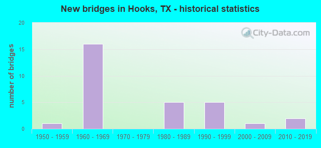
- New bridges - historical statistics
- 11950-1959
- 161960-1969
- 51980-1989
- 51990-1999
- 12000-2009
- 22010-2019
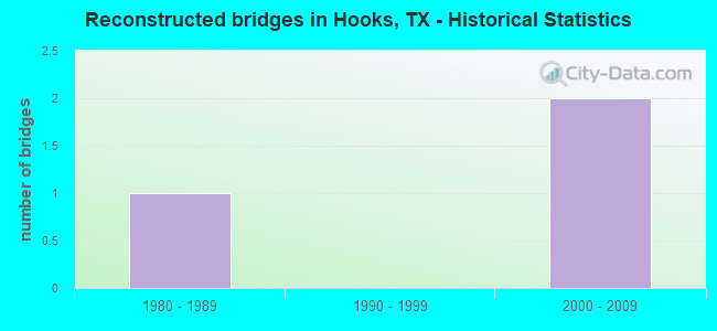
- Reconstructed bridges - Historical Statistics
- 11980-1989
- 01990-1999
- 22000-2009
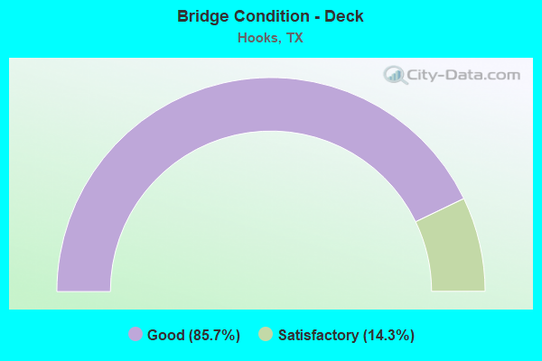
- Bridge Condition - Deck
- 85.7%Good
- 14.3%Satisfactory
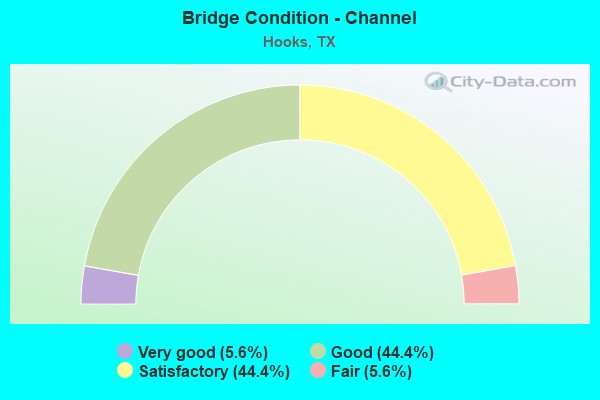
- Bridge Condition - Channel
- 5.6%Very good
- 44.4%Good
- 44.4%Satisfactory
- 5.6%Fair
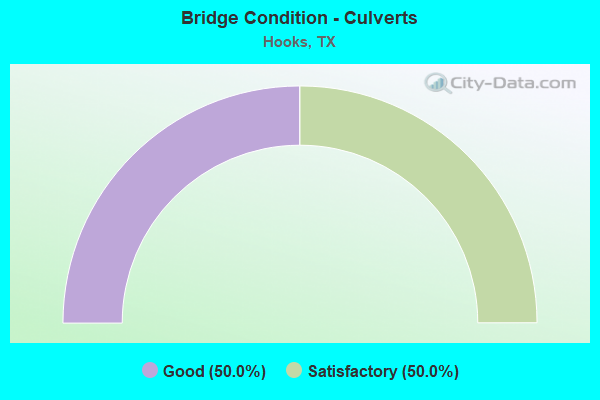
- Bridge Condition - Culverts
- 50.0%Good
- 50.0%Satisfactory
Find on map >> Show street view
Structure Number: 190190061006096, Location: 4.20 MI E OF SH 8 (Lat: 33.468381, Lng: -94.335900), Route carried "on" structure: State highway 86, Year Built: 1965, Status: Open, Structure Length: 7.99m (26.21ft), Average Daily Traffic: 3,040 (year 2013), Truck Traffic: 6%, Average Future Daily Traffic: 4,250 (year 2033), Design Load: HS 20, Features Intersected: IH 30
Minimum Vertical Clearance: 30+ m (98+ ft), Kilometerpoint: 0.113, Lanes on structure: 2, Lanes under structure: 4, Owner: State Highway Agency, Approaching Roadway Width: 8.5m (27.9ft), Material/Design: Prestressed concrete, Design/Construction: Stringer/Multi-beam, Number Of Spans In Main Unit: 4, Length of Maximum Span: 19.8m (65.0ft), Curb-To-Curb Width: 8.5m (27.9ft), Out-to-Out Width: 10.0m (32.8ft)
Condition: Deck: Satisfactory, Superstructure: Good, Substructure: Good, Operating Rating: 68.0 metric tons, Method Used To Determine Operating Rating: Load Factor (LF), Inventory Rating: 36.3 metric tons, Method Used To Determine Inventory Rating: Load Factor (LF), Structural Evaluation: Better than present minimum criteria, Deck Geometry: Meets minimum limits, Underclear: Somewhat better than minimum adequacy, Approach Roadway Alignment: Equal to present desirable criteria, Designated Inspection Frequency: Every 24 months, Inspection Date: July 2020, Deck Structure Type: Concrete Cast-file-Place
Find on map >> Show street view
Structure Number: 190190061006097, Location: 0.80 MI E OF SPUR 86 (Lat: 33.470097, Lng: -94.321614), Route carried "on" structure: Interstate 30, Year Built: 1965, Year Reconstructed: 2012, Status: Open, Structure Length: 1.16m (3.81ft), Average Daily Traffic: 33,443 (year 2020), Truck Traffic: 43%, Average Future Daily Traffic: 43,240 (year 2033), Design Load: HS 20, Features Intersected: E FORK PANTHER CREEK
Minimum Vertical Clearance: 30+ m (98+ ft), Kilometerpoint: 42.108, Lanes on structure: 8, Owner: State Highway Agency, Approaching Roadway Width: 37.8m (124.0ft), Skew: 29 degrees, Material/Design: Concrete, Design/Construction: Culvert, Number Of Spans In Main Unit: 4, Length of Maximum Span: 2.7m (8.9ft), Curb-To-Curb Width: 37.8m (124.0ft), Out-to-Out Width: 82.0m (269.0ft)
Condition: Channel: Satisfactory, Culverts: Good, Operating Rating: 39.9 metric tons, Method Used To Determine Operating Rating: Load Factor (LF), Inventory Rating: 23.6 metric tons, Method Used To Determine Inventory Rating: Load Factor (LF), Structural Evaluation: Somewhat better than minimum adequacy, Deck Geometry: Superior to present desirable criteria, Waterway Adequacy: Equal to present minimum criteria, Approach Roadway Alignment: Equal to present desirable criteria, Designated Inspection Frequency: Every 24 months, Inspection Date: July 2020
Find on map >> Show street view
Structure Number: 190190061006099, Location: 0.10 MI W OF FM 560 (Lat: 33.474208, Lng: -94.292017), Route carried "on" structure: Interstate 30, Year Built: 1965, Year Reconstructed: 2012, Status: Open, Structure Length: 0.91m (2.99ft), Average Daily Traffic: 33,443 (year 2020), Truck Traffic: 43%, Average Future Daily Traffic: 43,240 (year 2033), Design Load: HS 20, Features Intersected: E FORK PANTHER CREEK
Minimum Vertical Clearance: 30+ m (98+ ft), Kilometerpoint: 44.965, Lanes on structure: 8, Owner: State Highway Agency, Approaching Roadway Width: 43.3m (142.1ft), Skew: 21 degrees, Material/Design: Concrete, Design/Construction: Culvert, Number Of Spans In Main Unit: 4, Length of Maximum Span: 2.1m (6.9ft)
Condition: Channel: Satisfactory, Culverts: Satisfactory, Operating Rating: 39.9 metric tons, Method Used To Determine Operating Rating: Load Factor (LF), Inventory Rating: 23.6 metric tons, Method Used To Determine Inventory Rating: Load Factor (LF), Structural Evaluation: Somewhat better than minimum adequacy, Waterway Adequacy: Equal to present minimum criteria, Approach Roadway Alignment: Equal to present desirable criteria, Designated Inspection Frequency: Every 24 months, Inspection Date: July 2020
Find on map >> Show street view
Structure Number: 1901900610061, Location: 2.75 MI E OF SPUR 86 (Lat: 33.474644, Lng: -94.289369), Route carried "on" structure: Interstate 30, Year Built: 1965, Status: Open, Structure Length: 3.47m (11.38ft), Average Daily Traffic: 15,179 (year 2019), Truck Traffic: 43%, Average Future Daily Traffic: 21,620 (year 2033), Design Load: HS 20, Features Intersected: FM 560
Minimum Vertical Clearance: 30+ m (98+ ft), Kilometerpoint: 45.211, Lanes on structure: 2, Lanes under structure: 2, Owner: State Highway Agency, Approaching Roadway Width: 11.6m (38.1ft), Skew: 10 degrees, Material/Design: Concrete continuous, Design/Construction: Slab, Number Of Spans In Main Unit: 3, Length of Maximum Span: 13.7m (44.9ft), Curb-To-Curb Width: 12.0m (39.4ft), Out-to-Out Width: 12.7m (41.7ft)
Condition: Deck: Good, Superstructure: Good, Substructure: Good, Operating Rating: 52.6 metric tons, Method Used To Determine Operating Rating: Load Factor (LF), Inventory Rating: 31.7 metric tons, Method Used To Determine Inventory Rating: Load Factor (LF), Structural Evaluation: Better than present minimum criteria, Deck Geometry: Equal to present minimum criteria, Underclear: Somewhat better than minimum adequacy, Approach Roadway Alignment: Equal to present desirable criteria, Designated Inspection Frequency: Every 24 months, Inspection Date: July 2020, Deck Structure Type: Concrete Cast-file-Place, Wearing Surface/Protective System: Wearing Surface: Bituminous
Find on map >> Show street view
Structure Number: 190190061006101, Location: 2.75 MI E OF SPUR 86 (Lat: 33.474511, Lng: -94.289053), Route carried "on" structure: Interstate 30, Year Built: 1965, Status: Open, Structure Length: 3.47m (11.38ft), Average Daily Traffic: 19,157 (year 2019), Truck Traffic: 43%, Average Future Daily Traffic: 21,620 (year 2033), Design Load: HS 20, Features Intersected: FM 560
Minimum Vertical Clearance: 30+ m (98+ ft), Kilometerpoint: 45.215, Lanes on structure: 2, Lanes under structure: 2, Owner: State Highway Agency, Approaching Roadway Width: 11.6m (38.1ft), Skew: 10 degrees, Material/Design: Concrete continuous, Design/Construction: Slab, Number Of Spans In Main Unit: 3, Length of Maximum Span: 13.7m (44.9ft), Curb-To-Curb Width: 12.0m (39.4ft), Out-to-Out Width: 12.7m (41.7ft)
Condition: Deck: Good, Superstructure: Good, Substructure: Good, Operating Rating: 52.6 metric tons, Method Used To Determine Operating Rating: Load Factor (LF), Inventory Rating: 31.7 metric tons, Method Used To Determine Inventory Rating: Load Factor (LF), Structural Evaluation: Better than present minimum criteria, Deck Geometry: Equal to present minimum criteria, Underclear: Somewhat better than minimum adequacy, Approach Roadway Alignment: Equal to present desirable criteria, Designated Inspection Frequency: Every 24 months, Inspection Date: July 2020, Deck Structure Type: Concrete Cast-file-Place, Wearing Surface/Protective System: Wearing Surface: Bituminous
Find on map >> Show street view
Structure Number: 190190061006102, Location: 0.70 MI W OF FM 1398 (Lat: 33.476678, Lng: -94.270561), Route carried "on" structure: County highway 2112, Year Built: 1965, Status: Open, Structure Length: 7.01m (23.00ft), Average Daily Traffic: 230 (year 2013), Average Future Daily Traffic: 230 (year 2033), Design Load: H 15, Features Intersected: IH 30
Minimum Vertical Clearance: 30+ m (98+ ft), Kilometerpoint: 0.941, Lanes on structure: 2, Lanes under structure: 4, Owner: State Highway Agency, Approaching Roadway Width: 6.1m (20.0ft), Material/Design: Prestressed concrete, Design/Construction: Stringer/Multi-beam, Number Of Spans In Main Unit: 4, Length of Maximum Span: 19.8m (65.0ft), Curb-To-Curb Width: 7.3m (24.0ft), Out-to-Out Width: 8.3m (27.2ft)
Condition: Deck: Good, Superstructure: Good, Substructure: Good, Operating Rating: 56.2 metric tons, Method Used To Determine Operating Rating: Load Factor (LF), Inventory Rating: 29.9 metric tons, Method Used To Determine Inventory Rating: Load Factor (LF), Structural Evaluation: Better than present minimum criteria, Deck Geometry: Somewhat better than minimum adequacy, Underclear: Somewhat better than minimum adequacy, Approach Roadway Alignment: Equal to present minimum criteria, Designated Inspection Frequency: Every 24 months, Inspection Date: August 2020, Deck Structure Type: Concrete Cast-file-Place
Find on map >> Show street view
Structure Number: 190190061006103, Location: 1.80 MI E OF FM 560 (Lat: 33.475081, Lng: -94.258906), Route carried "on" structure: Interstate 30, Year Built: 1965, Status: Open, Structure Length: 5.79m (19.00ft), Average Daily Traffic: 15,302 (year 2019), Truck Traffic: 43%, Average Future Daily Traffic: 22,650 (year 2033), Design Load: HS 20, Features Intersected: FM 1398 & JONES CREEK
Minimum Vertical Clearance: 30+ m (98+ ft), Kilometerpoint: 48.052, Lanes on structure: 2, Lanes under structure: 2, Owner: State Highway Agency, Approaching Roadway Width: 12.2m (40.0ft), Skew: 1 degrees, Material/Design: Prestressed concrete, Design/Construction: Stringer/Multi-beam, Number Of Spans In Main Unit: 4, Length of Maximum Span: 15.2m (49.9ft), Curb-To-Curb Width: 11.7m (38.4ft), Out-to-Out Width: 12.7m (41.7ft)
Condition: Deck: Good, Superstructure: Good, Substructure: Good, Channel: Good, Operating Rating: 68.0 metric tons, Method Used To Determine Operating Rating: Load Factor (LF), Inventory Rating: 40.8 metric tons, Method Used To Determine Inventory Rating: Load Factor (LF), Structural Evaluation: Better than present minimum criteria, Deck Geometry: Equal to present minimum criteria, Underclear: Equal to present minimum criteria, Waterway Adequacy: Superior to present desirable criteria, Approach Roadway Alignment: Equal to present desirable criteria, Designated Inspection Frequency: Every 24 months, Inspection Date: August 2020, Deck Structure Type: Concrete Cast-file-Place, Wearing Surface/Protective System: Wearing Surface: Bituminous
Find on map >> Show street view
Structure Number: 190190061006104, Location: 1.80 MI E OF FM 560 (Lat: 33.474900, Lng: -94.258975), Route carried "on" structure: Interstate 30, Year Built: 1965, Status: Open, Structure Length: 5.79m (19.00ft), Average Daily Traffic: 20,074 (year 2019), Truck Traffic: 43%, Average Future Daily Traffic: 22,650 (year 2033), Design Load: HS 20, Features Intersected: FM 1398 & JONES CREEK
Minimum Vertical Clearance: 30+ m (98+ ft), Kilometerpoint: 48.052, Lanes on structure: 2, Lanes under structure: 2, Owner: State Highway Agency, Approaching Roadway Width: 12.2m (40.0ft), Skew: 1 degrees, Material/Design: Prestressed concrete, Design/Construction: Stringer/Multi-beam, Number Of Spans In Main Unit: 4, Length of Maximum Span: 15.2m (49.9ft), Curb-To-Curb Width: 11.7m (38.4ft), Out-to-Out Width: 12.7m (41.7ft)
Condition: Deck: Good, Superstructure: Good, Substructure: Good, Channel: Good, Operating Rating: 68.0 metric tons, Method Used To Determine Operating Rating: Load Factor (LF), Inventory Rating: 40.8 metric tons, Method Used To Determine Inventory Rating: Load Factor (LF), Structural Evaluation: Better than present minimum criteria, Deck Geometry: Equal to present minimum criteria, Underclear: Equal to present minimum criteria, Waterway Adequacy: Superior to present desirable criteria, Approach Roadway Alignment: Equal to present desirable criteria, Designated Inspection Frequency: Every 24 months, Inspection Date: August 2020, Deck Structure Type: Concrete Cast-file-Place, Wearing Surface/Protective System: Wearing Surface: Bituminous
Find on map >> Show street view
Structure Number: 190190061006115, Location: 1.00 MI W OF SPUR 86 (Lat: 33.469550, Lng: -94.353494), Route carried "on" structure: Interstate 30, Year Built: 1967, Status: Open, Structure Length: 0.73m (2.40ft), Average Daily Traffic: 32,846 (year 2019), Truck Traffic: 43%, Average Future Daily Traffic: 43,310 (year 2033), Design Load: HS 20, Features Intersected: PANTHER CREEK
Minimum Vertical Clearance: 30+ m (98+ ft), Kilometerpoint: 39.044, Lanes on structure: 4, Owner: State Highway Agency, Approaching Roadway Width: 22.6m (74.1ft), Skew: 21 degrees, Material/Design: Concrete, Design/Construction: Culvert, Number Of Spans In Main Unit: 3, Length of Maximum Span: 2.1m (6.9ft)
Condition: Channel: Good, Culverts: Good, Operating Rating: 39.9 metric tons, Method Used To Determine Operating Rating: Load Factor (LF), Inventory Rating: 23.6 metric tons, Method Used To Determine Inventory Rating: Load Factor (LF), Structural Evaluation: Somewhat better than minimum adequacy, Waterway Adequacy: Equal to present minimum criteria, Approach Roadway Alignment: Equal to present desirable criteria, Designated Inspection Frequency: Every 24 months, Inspection Date: June 2020
Find on map >> Show street view
Structure Number: 190190061006116, Location: 0.20 MI W OF SPUR 86 (Lat: 33.468428, Lng: -94.338456), Route carried "on" structure: Ramp Interstate 30, Year Built: 1967, Year Reconstructed: 1986, Status: Open, Structure Length: 0.67m (2.20ft), Average Daily Traffic: 3,090 (year 2013), Truck Traffic: 43%, Average Future Daily Traffic: 4,330 (year 2033), Design Load: HS 20, Features Intersected: BRANDHAM CREEK
Minimum Vertical Clearance: 30+ m (98+ ft), Kilometerpoint: 40.274, Lanes on structure: 6, Owner: State Highway Agency, Approaching Roadway Width: 37.8m (124.0ft), Skew: 9 degrees, Material/Design: Concrete, Design/Construction: Culvert, Number Of Spans In Main Unit: 3, Length of Maximum Span: 1.8m (5.9ft)
Condition: Channel: Very good, Culverts: Satisfactory, Operating Rating: 39.9 metric tons, Method Used To Determine Operating Rating: Load Factor (LF), Inventory Rating: 23.6 metric tons, Method Used To Determine Inventory Rating: Load Factor (LF), Structural Evaluation: Somewhat better than minimum adequacy, Waterway Adequacy: Equal to present minimum criteria, Approach Roadway Alignment: Equal to present desirable criteria, Designated Inspection Frequency: Every 24 months, Inspection Date: June 2020
Find on map >> Show street view
Structure Number: 190190061006215, Location: 1.40 MI W OF FM 560 (Lat: 33.471322, Lng: -94.312858), Route carried "on" structure: Spur US 594, Year Built: 2012, Status: Open, Structure Length: 7.07m (23.20ft), Average Daily Traffic: 830 (year 2011), Truck Traffic: 4%, Average Future Daily Traffic: 1,220 (year 2031), Design Load: HL 93, Features Intersected: IH 30
Minimum Vertical Clearance: 30+ m (98+ ft), Kilometerpoint: 0.166, Lanes on structure: 3, Lanes under structure: 4, Owner: State Highway Agency, Approaching Roadway Width: 17.7m (58.1ft), Skew: 1 degrees, Material/Design: Prestressed concrete, Design/Construction: Stringer/Multi-beam, Number Of Spans In Main Unit: 4, Length of Maximum Span: 19.8m (65.0ft), Curb-To-Curb Width: 17.5m (57.4ft), Out-to-Out Width: 18.3m (60.0ft)
Condition: Deck: Good, Superstructure: Good, Substructure: Good, Operating Rating: 54.4 metric tons, Method Used To Determine Operating Rating: Assigned ratings based on Load and Resistance Factor Design (LRFD) reported in metric tons, Inventory Rating: 32.7 metric tons, Method Used To Determine Inventory Rating: Assigned ratings based on Load and Resistance Factor Design (LRFD) reported in metric tons, Structural Evaluation: Better than present minimum criteria, Deck Geometry: Superior to present desirable criteria, Underclear: Equal to present minimum criteria, Approach Roadway Alignment: Equal to present desirable criteria, Designated Inspection Frequency: Every 24 months, Inspection Date: September 2020, Deck Structure Type: Concrete Precast Panels
Find on map >> Show street view
Structure Number: 190190102101006, Location: 0.10 MI S OF IH 30 (Lat: 33.471514, Lng: -94.289306), Route carried "on" structure: State highway 560, Year Built: 2006, Status: Open, Structure Length: 0.91m (2.99ft), Average Daily Traffic: 3,807 (year 2020), Truck Traffic: 7%, Average Future Daily Traffic: 7,380 (year 2033), Design Load: HS 20, Features Intersected: PANTHER CREEK
Minimum Vertical Clearance: 30+ m (98+ ft), Kilometerpoint: 7.377, Lanes on structure: 2, Owner: State Highway Agency, Approaching Roadway Width: 7.3m (24.0ft), Material/Design: Concrete, Design/Construction: Culvert, Number Of Spans In Main Unit: 4, Length of Maximum Span: 1.8m (5.9ft), Curb-To-Curb Width: 12.4m (40.7ft), Out-to-Out Width: 16.0m (52.5ft)
Condition: Channel: Good, Culverts: Good, Operating Rating: 54.4 metric tons, Method Used To Determine Operating Rating: Assigned rating based on Load Factor Design (LFD) reported in metric tons, Inventory Rating: 32.7 metric tons, Method Used To Determine Inventory Rating: Assigned rating based on Load Factor Design (LFD) reported in metric tons, Structural Evaluation: Better than present minimum criteria, Deck Geometry: Equal to present minimum criteria, Waterway Adequacy: Better than present minimum criteria, Approach Roadway Alignment: Equal to present desirable criteria, Designated Inspection Frequency: Every 48 months, Inspection Date: June 2020, Deck Structure Type: Concrete Cast-file-Place, Wearing Surface/Protective System: Wearing Surface: Bituminous
Find on map >> Show street view
Structure Number: 190190102101008, Location: 3.50 MI N OF IH 30 (Lat: 33.524769, Lng: -94.289164), Route carried "on" structure: State highway 560, Year Built: 1993, Status: Open, Structure Length: 2.29m (7.51ft), Average Daily Traffic: 244 (year 2020), Truck Traffic: 16%, Average Future Daily Traffic: 480 (year 2033), Design Load: HS 20, Features Intersected: BLACK BOTTOM CREEK
Minimum Vertical Clearance: 30+ m (98+ ft), Kilometerpoint: 1.466, Lanes on structure: 2, Owner: State Highway Agency, Approaching Roadway Width: 7.6m (24.9ft), Material/Design: Concrete, Design/Construction: Culvert, Number Of Spans In Main Unit: 7, Length of Maximum Span: 3.0m (9.8ft), Curb-To-Curb Width: 9.1m (29.9ft), Out-to-Out Width: 15.2m (49.9ft)
Condition: Channel: Satisfactory, Culverts: Satisfactory, Operating Rating: 39.9 metric tons, Method Used To Determine Operating Rating: Load Factor (LF), Inventory Rating: 23.6 metric tons, Method Used To Determine Inventory Rating: Load Factor (LF), Structural Evaluation: Equal to present minimum criteria, Deck Geometry: Equal to present minimum criteria, Waterway Adequacy: Meets minimum limits, Approach Roadway Alignment: Equal to present desirable criteria, Designated Inspection Frequency: Every 48 months, Inspection Date: June 2020, Deck Structure Type: Concrete Cast-file-Place, Wearing Surface/Protective System: Wearing Surface: Bituminous
Find on map >> Show street view
Structure Number: 190190102101009, Location: 2.20 MI N OF IH 30 (Lat: 33.506425, Lng: -94.289189), Route carried "on" structure: State highway 560, Year Built: 1994, Status: Open, Structure Length: 0.79m (2.59ft), Average Daily Traffic: 1,204 (year 2020), Truck Traffic: 17%, Average Future Daily Traffic: 2,740 (year 2033), Design Load: HS 20, Features Intersected: BARKMAN CREEK RELIEF
Minimum Vertical Clearance: 30+ m (98+ ft), Kilometerpoint: 3.545, Lanes on structure: 2, Owner: State Highway Agency, Approaching Roadway Width: 8.5m (27.9ft), Material/Design: Concrete, Design/Construction: Culvert, Number Of Spans In Main Unit: 3, Length of Maximum Span: 2.4m (7.9ft), Curb-To-Curb Width: 13.4m (44.0ft), Out-to-Out Width: 14.6m (47.9ft)
Condition: Channel: Good, Culverts: Good, Operating Rating: 39.9 metric tons, Method Used To Determine Operating Rating: Load Factor (LF), Inventory Rating: 23.6 metric tons, Method Used To Determine Inventory Rating: Load Factor (LF), Structural Evaluation: Equal to present minimum criteria, Deck Geometry: Equal to present desirable criteria, Waterway Adequacy: Better than present minimum criteria, Approach Roadway Alignment: Equal to present desirable criteria, Designated Inspection Frequency: Every 48 months, Inspection Date: June 2020, Deck Structure Type: Concrete Cast-file-Place, Wearing Surface/Protective System: Wearing Surface: Bituminous
Find on map >> Show street view
Structure Number: 19019010210101, Location: 2.10 MI N OF IH 30 (Lat: 33.504525, Lng: -94.289175), Route carried "on" structure: State highway 560, Year Built: 1994, Status: Open, Structure Length: 2.29m (7.51ft), Average Daily Traffic: 1,204 (year 2020), Truck Traffic: 17%, Average Future Daily Traffic: 2,740 (year 2033), Design Load: HS 20, Features Intersected: BARKMAN CREEK
Minimum Vertical Clearance: 30+ m (98+ ft), Kilometerpoint: 3.692, Lanes on structure: 2, Owner: State Highway Agency, Approaching Roadway Width: 8.5m (27.9ft), Material/Design: Concrete, Design/Construction: Culvert, Number Of Spans In Main Unit: 7, Length of Maximum Span: 3.0m (9.8ft), Curb-To-Curb Width: 13.4m (44.0ft), Out-to-Out Width: 17.1m (56.1ft)
Condition: Channel: Good, Culverts: Good, Operating Rating: 39.9 metric tons, Method Used To Determine Operating Rating: Load Factor (LF), Inventory Rating: 23.6 metric tons, Method Used To Determine Inventory Rating: Load Factor (LF), Structural Evaluation: Equal to present minimum criteria, Deck Geometry: Equal to present desirable criteria, Waterway Adequacy: Better than present minimum criteria, Approach Roadway Alignment: Equal to present desirable criteria, Designated Inspection Frequency: Every 48 months, Inspection Date: June 2020, Deck Structure Type: Concrete Cast-file-Place, Wearing Surface/Protective System: Wearing Surface: Bituminous
Find on map >> Show street view
Structure Number: 190190102101011, Location: 1.80 MI N OF IH 30 (Lat: 33.500461, Lng: -94.289200), Route carried "on" structure: State highway 560, Year Built: 1994, Status: Open, Structure Length: 0.79m (2.59ft), Average Daily Traffic: 1,204 (year 2020), Truck Traffic: 17%, Average Future Daily Traffic: 2,740 (year 2033), Design Load: HS 20, Features Intersected: DRAW
Minimum Vertical Clearance: 30+ m (98+ ft), Kilometerpoint: 4.136, Lanes on structure: 2, Owner: State Highway Agency, Approaching Roadway Width: 8.5m (27.9ft), Material/Design: Concrete, Design/Construction: Culvert, Number Of Spans In Main Unit: 3, Length of Maximum Span: 2.4m (7.9ft), Curb-To-Curb Width: 13.4m (44.0ft), Out-to-Out Width: 14.6m (47.9ft)
Condition: Channel: Satisfactory, Culverts: Satisfactory, Operating Rating: 39.9 metric tons, Method Used To Determine Operating Rating: Load Factor (LF), Inventory Rating: 23.6 metric tons, Method Used To Determine Inventory Rating: Load Factor (LF), Structural Evaluation: Equal to present minimum criteria, Deck Geometry: Equal to present desirable criteria, Waterway Adequacy: Better than present minimum criteria, Approach Roadway Alignment: Equal to present desirable criteria, Designated Inspection Frequency: Every 48 months, Inspection Date: June 2020, Deck Structure Type: Concrete Cast-file-Place, Wearing Surface/Protective System: Wearing Surface: Bituminous
Find on map >> Show street view
Structure Number: 190190138101002, Location: 0.02 MI N OF IH 30 (Lat: 33.475217, Lng: -94.259036), Route carried "on" structure: State highway 1398, Year Built: 1951, Status: Open, Structure Length: 1.07m (3.51ft), Average Daily Traffic: 817 (year 2020), Truck Traffic: 17%, Average Future Daily Traffic: 1,350 (year 2033), Design Load: HS 20, Features Intersected: JONES CREEK
Minimum Vertical Clearance: 30+ m (98+ ft), Kilometerpoint: 2.678, Lanes on structure: 2, Owner: State Highway Agency, Approaching Roadway Width: 7.3m (24.0ft), Material/Design: Concrete, Design/Construction: Culvert, Number Of Spans In Main Unit: 4, Length of Maximum Span: 2.4m (7.9ft), Curb-To-Curb Width: 7.3m (24.0ft), Out-to-Out Width: 7.7m (25.3ft)
Condition: Channel: Good, Culverts: Good, Operating Rating: 39.9 metric tons, Method Used To Determine Operating Rating: Load Factor (LF), Inventory Rating: 23.6 metric tons, Method Used To Determine Inventory Rating: Load Factor (LF), Structural Evaluation: Equal to present minimum criteria, Deck Geometry: Meets minimum limits, Waterway Adequacy: Equal to present minimum criteria, Approach Roadway Alignment: Equal to present desirable criteria, Length Of Structure Improvement: 1.07m (3.51ft), Designated Inspection Frequency: Every 24 months, Inspection Date: July 2020, Deck Structure Type: Concrete Cast-file-Place, Wearing Surface/Protective System: Wearing Surface: Bituminous
Find on map >> Show street view
Structure Number: 190190138101005, Location: 1.60 MI N OF IH 30 (Lat: 33.498875, Lng: -94.258872), Route carried "on" structure: State highway 1398, Year Built: 1991, Status: Open, Structure Length: 2.96m (9.71ft), Average Daily Traffic: 444 (year 2020), Truck Traffic: 17%, Average Future Daily Traffic: 590 (year 2033), Design Load: HS 20, Features Intersected: BARKMAN CREEK
Minimum Vertical Clearance: 30+ m (98+ ft), Kilometerpoint: 5.309, Lanes on structure: 2, Owner: State Highway Agency, Approaching Roadway Width: 7.9m (25.9ft), Material/Design: Concrete, Design/Construction: Culvert, Number Of Spans In Main Unit: 9, Length of Maximum Span: 3.0m (9.8ft)
Condition: Channel: Fair, Culverts: Satisfactory, Operating Rating: 39.9 metric tons, Method Used To Determine Operating Rating: Load Factor (LF), Inventory Rating: 23.6 metric tons, Method Used To Determine Inventory Rating: Load Factor (LF), Structural Evaluation: Equal to present minimum criteria, Waterway Adequacy: Equal to present minimum criteria, Approach Roadway Alignment: Equal to present desirable criteria, Designated Inspection Frequency: Every 24 months, Inspection Date: June 2020
Find on map >> Show street view
Structure Number: 190190AA0242001, Location: 1.5 MI NE OF FM 560 (Lat: 33.496986, Lng: -94.273558), Route carried "on" structure: County highway 2111, Year Built: 1985, Status: Open, Structure Length: 0.82m (2.69ft), Average Daily Traffic: 440 (year 2013), Average Future Daily Traffic: 440 (year 2033), Design Load: HS 20, Features Intersected: BARKMAN CREEK TRIBUTARY
Minimum Vertical Clearance: 30+ m (98+ ft), Kilometerpoint: 2.414, Lanes on structure: 2, Owner: County Highway Agency, Approaching Roadway Width: 6.1m (20.0ft), Material/Design: Concrete, Design/Construction: Culvert, Number Of Spans In Main Unit: 3, Length of Maximum Span: 2.4m (7.9ft)
Condition: Channel: Satisfactory, Culverts: Good, Operating Rating: 39.9 metric tons, Method Used To Determine Operating Rating: Load Factor (LF), Inventory Rating: 23.6 metric tons, Method Used To Determine Inventory Rating: Load Factor (LF), Structural Evaluation: Equal to present minimum criteria, Waterway Adequacy: Better than present minimum criteria, Approach Roadway Alignment: Better than present minimum criteria, Designated Inspection Frequency: Every 24 months, Inspection Date: May 2020
Find on map >> Show street view
Structure Number: 190190C00080001, Location: 0.25 MI E OF MAIN ST (Lat: 33.467358, Lng: -94.285231), Route carried "on" structure: City street , Year Built: 1986, Status: Open, Structure Length: 0.82m (2.69ft), Average Daily Traffic: 254 (year 2013), Average Future Daily Traffic: 254 (year 2033), Design Load: HS 20, Features Intersected: PANTHER CREEK, Facility Carried by Structure: AVE B
Minimum Vertical Clearance: 30+ m (98+ ft), Kilometerpoint: 0.370, Lanes on structure: 2, Owner: City or Municipal Highway Agency, Approaching Roadway Width: 6.1m (20.0ft), Skew: 1 degrees, Material/Design: Concrete, Design/Construction: Culvert, Number Of Spans In Main Unit: 3, Length of Maximum Span: 2.4m (7.9ft), Curb-To-Curb Width: 8.4m (27.6ft), Out-to-Out Width: 9.1m (29.9ft)
Condition: Channel: Satisfactory, Culverts: Good, Operating Rating: 39.9 metric tons, Method Used To Determine Operating Rating: Load Factor (LF), Inventory Rating: 23.6 metric tons, Method Used To Determine Inventory Rating: Load Factor (LF), Structural Evaluation: Equal to present minimum criteria, Deck Geometry: Somewhat better than minimum adequacy, Waterway Adequacy: Better than present minimum criteria, Approach Roadway Alignment: Equal to present desirable criteria, Designated Inspection Frequency: Every 24 months, Inspection Date: May 2020, Deck Structure Type: Concrete Cast-file-Place
Find on map >> Show street view
Structure Number: 190190C00155001, Location: 0.2 MI N OF US 82 (Lat: 33.468831, Lng: -94.286953), Route carried "on" structure: City street , Year Built: 1985, Status: Open, Structure Length: 1.04m (3.41ft), Average Daily Traffic: 233 (year 2013), Average Future Daily Traffic: 233 (year 2033), Design Load: HS 20, Features Intersected: PANTHER CREEK, Facility Carried by Structure: E 2ND ST
Minimum Vertical Clearance: 30+ m (98+ ft), Kilometerpoint: 0.161, Lanes on structure: 2, Owner: City or Municipal Highway Agency, Approaching Roadway Width: 6.1m (20.0ft), Skew: 3 degrees, Material/Design: Concrete, Design/Construction: Culvert, Number Of Spans In Main Unit: 3, Length of Maximum Span: 2.7m (8.9ft), Curb-To-Curb Width: 8.4m (27.6ft), Out-to-Out Width: 9.1m (29.9ft)
Condition: Channel: Satisfactory, Culverts: Satisfactory, Operating Rating: 39.9 metric tons, Method Used To Determine Operating Rating: Load Factor (LF), Inventory Rating: 23.6 metric tons, Method Used To Determine Inventory Rating: Load Factor (LF), Structural Evaluation: Equal to present minimum criteria, Deck Geometry: Somewhat better than minimum adequacy, Waterway Adequacy: Meets minimum limits, Approach Roadway Alignment: Equal to present desirable criteria, Designated Inspection Frequency: Every 24 months, Inspection Date: May 2020, Deck Structure Type: Concrete Cast-file-Place, Wearing Surface/Protective System: Wearing Surface: Bituminous
Find on map >> Show street view
Structure Number: 190190C00315001, Location: 0.2 MI W OF FM 1398 (Lat: 33.471975, Lng: -94.262878), Route carried "on" structure: City street , Year Built: 1985, Status: Open, Structure Length: 1.31m (4.30ft), Average Daily Traffic: 204 (year 2013), Average Future Daily Traffic: 204 (year 2033), Design Load: HS 20, Features Intersected: JONES CREEK, Facility Carried by Structure: WASHINGTON AVE.
Minimum Vertical Clearance: 30+ m (98+ ft), Kilometerpoint: 0.097, Lanes on structure: 2, Owner: City or Municipal Highway Agency, Approaching Roadway Width: 6.7m (22.0ft), Material/Design: Concrete, Design/Construction: Culvert, Number Of Spans In Main Unit: 4, Length of Maximum Span: 3.0m (9.8ft), Curb-To-Curb Width: 10.3m (33.8ft), Out-to-Out Width: 11.0m (36.1ft)
Condition: Channel: Good, Culverts: Satisfactory, Operating Rating: 39.9 metric tons, Method Used To Determine Operating Rating: Load Factor (LF), Inventory Rating: 23.6 metric tons, Method Used To Determine Inventory Rating: Load Factor (LF), Structural Evaluation: Equal to present minimum criteria, Deck Geometry: Better than present minimum criteria, Waterway Adequacy: Equal to present minimum criteria, Approach Roadway Alignment: Equal to present desirable criteria, Designated Inspection Frequency: Every 24 months, Inspection Date: May 2020, Deck Structure Type: Concrete Cast-file-Place
Find on map >> Show street view
Structure Number: 190190C00375001, Location: 0.35 MI W OF FM 1398 (Lat: 33.469225, Lng: -94.264500), Route carried "on" structure: City street , Year Built: 1985, Status: Open, Structure Length: 1.01m (3.31ft), Average Daily Traffic: 348 (year 2013), Average Future Daily Traffic: 348 (year 2033), Design Load: HS 20, Features Intersected: JONES CREEK, Facility Carried by Structure: POUNDS ST
Minimum Vertical Clearance: 30+ m (98+ ft), Kilometerpoint: 0.016, Lanes on structure: 2, Owner: City or Municipal Highway Agency, Approaching Roadway Width: 6.7m (22.0ft), Material/Design: Concrete, Design/Construction: Culvert, Number Of Spans In Main Unit: 3, Length of Maximum Span: 3.0m (9.8ft), Curb-To-Curb Width: 8.4m (27.6ft), Out-to-Out Width: 9.1m (29.9ft)
Condition: Channel: Satisfactory, Culverts: Satisfactory, Operating Rating: 39.9 metric tons, Method Used To Determine Operating Rating: Load Factor (LF), Inventory Rating: 23.6 metric tons, Method Used To Determine Inventory Rating: Load Factor (LF), Structural Evaluation: Equal to present minimum criteria, Deck Geometry: Somewhat better than minimum adequacy, Waterway Adequacy: Better than present minimum criteria, Approach Roadway Alignment: Equal to present minimum criteria, Designated Inspection Frequency: Every 24 months, Inspection Date: May 2020, Deck Structure Type: Concrete Cast-file-Place
Find on map >> Show street view
Structure Number: 190190061006096, Location: 4.20 MI E OF SH 8 (Lat: 33.468381, Lng: -94.335900), Route carried "under" structure: Interstate 30, Year Built: 1965, Structure Length: 0. m, Average Daily Traffic: 30,880 (year 2013), Truck Traffic: 43%, Features Intersected: IH 30, Facility Carried by Structure: SPUR 86
Minimum Vertical Clearance: 5.08m (16.67ft), Kilometerpoint: 40.755, Material/Design: Prestressed concrete, Design/Construction: Stringer/Multi-beam, Length of Maximum Span: 19.8m (65.0ft)
Find on map >> Show street view
Structure Number: 1901900610061, Location: 2.75 MI E OF SPUR 86 (Lat: 33.474600, Lng: -94.289300), Route carried "under" structure: State highway 560, Year Built: 1965, Structure Length: 0. m, Average Daily Traffic: 1,960 (year 2013), Truck Traffic: 17%, Features Intersected: FM 560, Facility Carried by Structure: IH 30 WB
Minimum Vertical Clearance: 5.01m (16.44ft), Kilometerpoint: 7.002, Material/Design: Concrete continuous, Design/Construction: Slab, Length of Maximum Span: 13.7m (44.9ft)
Find on map >> Show street view
Structure Number: 190190061006101, Location: 2.75 MI E OF SPUR 86 (Lat: 33.474500, Lng: -94.289000), Route carried "under" structure: State highway 560, Year Built: 1965, Structure Length: 0. m, Average Daily Traffic: 5,270 (year 2013), Truck Traffic: 7%, Features Intersected: FM 560, Facility Carried by Structure: IH 30 EB
Minimum Vertical Clearance: 5.05m (16.57ft), Kilometerpoint: 7.023, Material/Design: Concrete continuous, Design/Construction: Slab, Length of Maximum Span: 13.7m (44.9ft)
Find on map >> Show street view
Structure Number: 190190061006102, Location: 0.70 MI W OF FM 1398 (Lat: 33.476678, Lng: -94.270561), Route carried "under" structure: Interstate 30, Year Built: 1965, Structure Length: 0. m, Average Daily Traffic: 30,880 (year 2013), Truck Traffic: 43%, Features Intersected: IH 30, Facility Carried by Structure: CR 2112(GARDEN RD)
Minimum Vertical Clearance: 5.16m (16.93ft), Kilometerpoint: 46.998, Material/Design: Prestressed concrete, Design/Construction: Stringer/Multi-beam, Length of Maximum Span: 19.8m (65.0ft)
Find on map >> Show street view
Structure Number: 190190061006103, Location: 1.80 MI E OF FM 560 (Lat: 33.475000, Lng: -94.258900), Route carried "under" structure: State highway 1398, Year Built: 1965, Structure Length: 0. m, Average Daily Traffic: 960 (year 2013), Truck Traffic: 17%, Features Intersected: FM 1398 & JONES CREEK, Facility Carried by Structure: IH 30 WB
Minimum Vertical Clearance: 4.72m (15.49ft), Kilometerpoint: 2.670, Material/Design: Prestressed concrete, Design/Construction: Stringer/Multi-beam, Length of Maximum Span: 15.2m (49.9ft)
Find on map >> Show street view
Structure Number: 190190061006104, Location: 1.80 MI E OF FM 560 (Lat: 33.474900, Lng: -94.258900), Route carried "under" structure: State highway 1398, Year Built: 1965, Structure Length: 0. m, Average Daily Traffic: 2,200 (year 2013), Truck Traffic: 17%, Features Intersected: FM 1398 & JONES CREEK, Facility Carried by Structure: IH 30 EB
Minimum Vertical Clearance: 4.72m (15.49ft), Kilometerpoint: 2.646, Material/Design: Prestressed concrete, Design/Construction: Stringer/Multi-beam, Length of Maximum Span: 15.2m (49.9ft)
Find on map >> Show street view
Structure Number: 190190061006215, Location: 1.40 MI W OF FM 560 (Lat: 33.471322, Lng: -94.312858), Route carried "under" structure: Interstate 30, Year Built: 2012, Structure Length: 0. m, Average Daily Traffic: 30,040 (year 2011), Truck Traffic: 30%, Features Intersected: IH 30, Facility Carried by Structure: SPUR 594
Minimum Vertical Clearance: 5.18m (16.99ft), Kilometerpoint: 42.934, Material/Design: Prestressed concrete, Design/Construction: Stringer/Multi-beam, Length of Maximum Span: 19.8m (65.0ft)