Bridge Statistics for Hood River, Oregon (OR)
Condition, Traffic, Stress, Structural Evaluation, Project Costs
- National Bridge Inventory (NBI) Statistics
- 21Number of bridges
- 886ft / 270mTotal length
- $37,212,000Total costs
- 268,705Total average daily traffic
- 70,517Total average daily truck traffic
- National Bridge Inventory (NBI) Registered Bridges for Hood River
- No street view available for this location
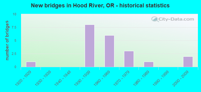
- New bridges - historical statistics
- 11920-1929
- 81950-1959
- 61960-1969
- 31970-1979
- 11980-1989
- 22000-2009
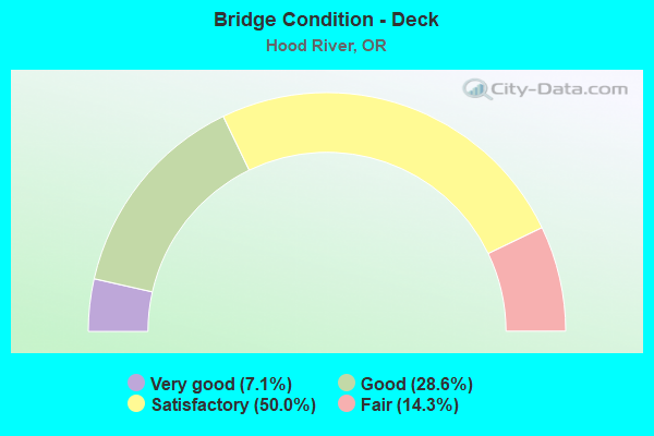
- Bridge Condition - Deck
- 7.1%Very good
- 28.6%Good
- 50.0%Satisfactory
- 14.3%Fair
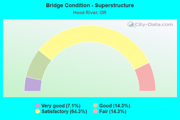
- Bridge Condition - Superstructure
- 7.1%Very good
- 14.3%Good
- 64.3%Satisfactory
- 14.3%Fair
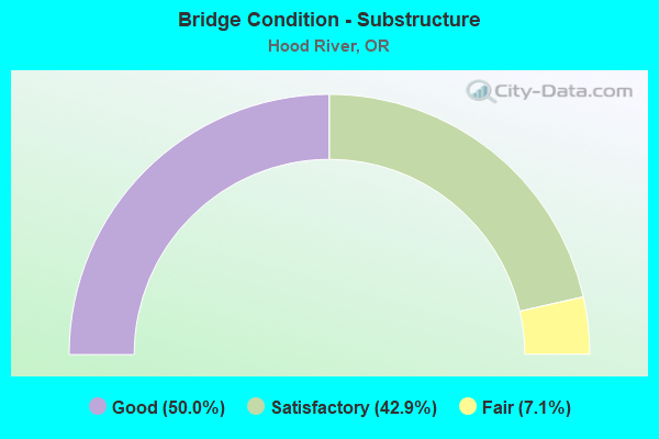
- Bridge Condition - Substructure
- 50.0%Good
- 42.9%Satisfactory
- 7.1%Fair
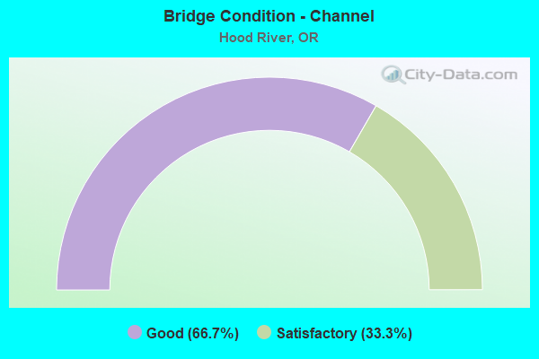
- Bridge Condition - Channel
- 66.7%Good
- 33.3%Satisfactory
Find on map >> Show street view
Structure Number: 200A026 10236, Location: AT ECL HOOD RIVER (Lat: 45.707950, Lng: -121.505589), Route carried "on" structure: US 35, Year Built: 1982, Status: Open, Structure Length: 20.67m (67.81ft), Average Daily Traffic: 7,696 (year 2020), Truck Traffic: 2%, Average Future Daily Traffic: 8,300 (year 2040), Design Load: HS 20, Features Intersected: HOOD RIVER & UPRR, Facility Carried by Structure: HWY 100
Minimum Vertical Clearance: 30+ m (98+ ft), Kilometerpoint: 82.254, Lanes on structure: 2, Base Highway Network: Yes, Owner: State Highway Agency, Approaching Roadway Width: 10.4m (34.1ft), Skew: 2 degrees, Navigation Control: Yes ( Vertical Clearance: 7.0m (23.0ft), Horizontal Clearance: 34.4m (112.9ft)), Material/Design: Prestressed concrete continuous, Design/Construction: Box Beam or Girders - Multiple, Number Of Spans In Main Unit: 5, Number Of Approach Spans: 3, Length of Maximum Span: 42.7m (140.1ft), Curb or Sidewalk Widths: Left: 0.0m, Right: 1.5m (4.9ft), Curb-To-Curb Width: 10.4m (34.1ft), Out-to-Out Width: 14.7m (48.2ft)
Condition: Deck: Good, Superstructure: Good, Substructure: Good, Channel: Good, Operating Rating: 35.6 metric tons, Method Used To Determine Operating Rating: Load and Resistance Factor Rating (LRFR) rating reported by rating factor(RF) method using HL-93 loadings, Inventory Rating: 27.5 metric tons, Method Used To Determine Inventory Rating: Load and Resistance Factor Rating (LRFR) rating reported by rating factor(RF) method using HL-93 loadings, Structural Evaluation: Equal to present minimum criteria, Deck Geometry: Meets minimum limits, Underclear: Equal to present desirable criteria, Waterway Adequacy: Equal to present desirable criteria, Approach Roadway Alignment: Equal to present desirable criteria, Designated Inspection Frequency: Every 24 months, Underwater Inspection Frequency: Every 60 months, Inspection Date: June 2021, Underwater Inspection Date: August 2021, Deck Structure Type: Concrete Cast-file-Place, Wearing Surface/Protective System: Wearing Surface: Monolithic Concrete
Find on map >> Show street view
Structure Number: 2443 002 06341, Location: IN HOOD RIVER (Lat: 45.713000, Lng: -121.522569), Route carried "on" structure: Interstate 84, Year Built: 1953, Year Reconstructed: 2002, Status: Open, Structure Length: 18.26m (59.91ft), Average Daily Traffic: 14,157 (year 2020), Truck Traffic: 28%, Average Future Daily Traffic: 18,750 (year 2040), Design Load: HS 20, Features Intersected: UPRR
Minimum Vertical Clearance: 30+ m (98+ ft), Kilometerpoint: 102.049, Lanes on structure: 2, Base Highway Network: Yes, Owner: State Highway Agency, Approaching Roadway Width: 10.4m (34.1ft), Material/Design: Prestressed concrete continuous, Design/Construction: Girder and Floorbeam System, Number Of Spans In Main Unit: 9, Number Of Approach Spans: 3, Length of Maximum Span: 32.0m (105.0ft), Curb or Sidewalk Widths: Left: 1.1m (3.6ft), Right: 1.1m (3.6ft), Curb-To-Curb Width: 9.1m (29.9ft), Out-to-Out Width: 11.9m (39.0ft)
Condition: Deck: Fair, Superstructure: Satisfactory, Substructure: Satisfactory, Operating Rating: 22.7 metric tons, Method Used To Determine Operating Rating: Load and Resistance Factor Rating (LRFR) rating reported by rating factor(RF) method using HL-93 loadings, Inventory Rating: 17.5 metric tons, Method Used To Determine Inventory Rating: Load and Resistance Factor Rating (LRFR) rating reported by rating factor(RF) method using HL-93 loadings, Structural Evaluation: Meets minimum limits, Deck Geometry: Meets minimum limits, Underclear: Meets minimum limits, Approach Roadway Alignment: Equal to present desirable criteria, Designated Inspection Frequency: Every 24 months, Inspection Date: July 2020, Deck Structure Type: Concrete Cast-file-Place, Wearing Surface/Protective System: Wearing Surface: Latex Concrete
Find on map >> Show street view
Structure Number: 2444 002 06415, Location: AT HOOD RIVER (Lat: 45.710350, Lng: -121.507689), Route carried "on" structure: Interstate 84, Year Built: 1953, Status: Open, Structure Length: 11.22m (36.81ft), Average Daily Traffic: 14,157 (year 2020), Truck Traffic: 28%, Average Future Daily Traffic: 18,750 (year 2040), Design Load: HS 20, Features Intersected: HOOD RIVER
Minimum Vertical Clearance: 30+ m (98+ ft), Kilometerpoint: 103.239, Lanes on structure: 3, Base Highway Network: Yes, Owner: State Highway Agency, Approaching Roadway Width: 11.6m (38.1ft), Material/Design: Steel continuous, Design/Construction: Girder and Floorbeam System, Number Of Spans In Main Unit: 3, Length of Maximum Span: 43.3m (142.1ft), Curb-To-Curb Width: 9.1m (29.9ft), Out-to-Out Width: 11.9m (39.0ft)
Condition: Deck: Very good, Superstructure: Satisfactory, Substructure: Good, Channel: Good, Operating Rating: 32.4 metric tons, Method Used To Determine Operating Rating: Load and Resistance Factor Rating (LRFR) rating reported by rating factor(RF) method using HL-93 loadings, Inventory Rating: 24.9 metric tons, Method Used To Determine Inventory Rating: Load and Resistance Factor Rating (LRFR) rating reported by rating factor(RF) method using HL-93 loadings, Structural Evaluation: Equal to present minimum criteria, Deck Geometry: High priority of replacement, Waterway Adequacy: Equal to present desirable criteria, Approach Roadway Alignment: Equal to present desirable criteria, Length Of Structure Improvement: 11.20m (36.75ft), Designated Inspection Frequency: Every 24 months, Critical Feature Inspection Frequency: Every 24 months, Underwater Inspection Frequency: Every 60 months, Inspection Date: June 2021, Critical Feature Inspection Date: October 2021, Underwater Inspection Date: October 2019, Bridge Improvement Cost: $1,178,000, Roadway Improvement Cost: $118,000, Total Project Cost: $1,885,000, Deck Structure Type: Concrete Cast-file-Place, Wearing Surface/Protective System: Wearing Surface: Monolithic Concrete, Deck Protection: Epoxy Coated Reinforcing
Find on map >> Show street view
Structure Number: 2444A002 06415, Location: AT HOOD RIVER (Lat: 45.710306, Lng: -121.507694), Route carried "on" structure: Interstate 84, Year Built: 1962, Status: Open, Structure Length: 11.22m (36.81ft), Average Daily Traffic: 14,157 (year 2020), Truck Traffic: 28%, Average Future Daily Traffic: 18,750 (year 2040), Design Load: HS 20, Features Intersected: HOOD RIVER
Minimum Vertical Clearance: 30+ m (98+ ft), Kilometerpoint: 103.239, Lanes on structure: 3, Base Highway Network: Yes, Owner: State Highway Agency, Approaching Roadway Width: 11.6m (38.1ft), Material/Design: Steel continuous, Design/Construction: Stringer/Multi-beam, Number Of Spans In Main Unit: 3, Length of Maximum Span: 43.3m (142.1ft), Curb-To-Curb Width: 12.1m (39.7ft), Out-to-Out Width: 13.3m (43.6ft)
Condition: Deck: Satisfactory, Superstructure: Fair, Substructure: Satisfactory, Channel: Satisfactory, Operating Rating: 24.3 metric tons, Method Used To Determine Operating Rating: Load and Resistance Factor Rating (LRFR) rating reported by rating factor(RF) method using HL-93 loadings, Inventory Rating: 18.8 metric tons, Method Used To Determine Inventory Rating: Load and Resistance Factor Rating (LRFR) rating reported by rating factor(RF) method using HL-93 loadings, Structural Evaluation: Meets minimum limits, Deck Geometry: High priority of corrective action, Waterway Adequacy: Better than present minimum criteria, Approach Roadway Alignment: Equal to present desirable criteria, Length Of Structure Improvement: 11.20m (36.75ft), Designated Inspection Frequency: Every 24 months, Underwater Inspection Frequency: Every 60 months, Inspection Date: June 2021, Underwater Inspection Date: October 2019, Bridge Improvement Cost: $1,178,000, Roadway Improvement Cost: $118,000, Total Project Cost: $1,885,000, Deck Structure Type: Concrete Cast-file-Place, Wearing Surface/Protective System: Wearing Surface: Latex Concrete
Find on map >> Show street view
Structure Number: 2471B002C06428, Location: IN HOOD RIVER (Lat: 45.709481, Lng: -121.504400), Route carried "on" structure: ServiceState highway 84, Year Built: 1974, Status: Open, Structure Length: 16.22m (53.22ft), Average Daily Traffic: 7,799 (year 2020), Truck Traffic: 37%, Average Future Daily Traffic: 10,100 (year 2030), Design Load: HS 20, Features Intersected: UPRR & FRONTAGE RD, Facility Carried by Structure: HWY 002 DU
Minimum Vertical Clearance: 30+ m (98+ ft), Kilometerpoint: 103.400, Lanes on structure: 2, Lanes under structure: 2, Base Highway Network: Yes, Owner: State Highway Agency, Approaching Roadway Width: 12.2m (40.0ft), Material/Design: Concrete continuous, Design/Construction: Box Beam or Girders - Multiple, Number Of Spans In Main Unit: 6, Length of Maximum Span: 27.4m (89.9ft), Curb or Sidewalk Widths: Left: 0.0m, Right: 1.8m (5.9ft), Curb-To-Curb Width: 12.2m (40.0ft), Out-to-Out Width: 15.1m (49.5ft)
Condition: Deck: Satisfactory, Superstructure: Satisfactory, Substructure: Good, Operating Rating: 36.9 metric tons, Method Used To Determine Operating Rating: Load and Resistance Factor Rating (LRFR) rating reported by rating factor(RF) method using HL-93 loadings, Inventory Rating: 28.5 metric tons, Method Used To Determine Inventory Rating: Load and Resistance Factor Rating (LRFR) rating reported by rating factor(RF) method using HL-93 loadings, Structural Evaluation: Equal to present minimum criteria, Deck Geometry: Somewhat better than minimum adequacy, Underclear: High priority of corrective action, Approach Roadway Alignment: Equal to present desirable criteria, Length Of Structure Improvement: 16.20m (53.15ft), Designated Inspection Frequency: Every 24 months, Inspection Date: June 2021, Bridge Improvement Cost: $1,704,000, Roadway Improvement Cost: $170,000, Total Project Cost: $2,726,000, Deck Structure Type: Concrete Cast-file-Place, Wearing Surface/Protective System: Wearing Surface: Monolithic Concrete
Find on map >> Show street view
Structure Number: 6645 002C06462, Location: Hood River (Lat: 45.718236, Lng: -121.494903), Route carried "on" structure: Other road , Year Built: 1924, Status: Posted for load, Structure Length: 134.66m (441.80ft), Average Daily Traffic: 12,861 (year 2020), Truck Traffic: 28%, Average Future Daily Traffic: 9,548 (year 2030), Design Load: H 15, Features Intersected: COLUMBIA RIVER, Facility Carried by Structure: I-84 White Salmon
Minimum Vertical Clearance: 4.80m (15.75ft), Kilometerpoint: 103.996, Lanes on structure: 2, Toll: Toll bridge, Owner: Local Toll Authority, Approaching Roadway Width: 6.7m (22.0ft), Navigation Control: Yes ( Vertical Clearance: 41.1m (134.8ft), Horizontal Clearance: 76.8m (252.0ft)), Material/Design: Steel, Design/Construction: Movable - Lift, Number Of Spans In Main Unit: 19, Number Of Approach Spans: 10, Length of Maximum Span: 79.9m (262.1ft), Curb-To-Curb Width: 5.7m (18.7ft), Out-to-Out Width: 5.9m (19.4ft)
Condition: Deck: Fair, Superstructure: Fair, Substructure: Fair, Channel: Good, Operating Rating: 13.3 metric tons, Method Used To Determine Operating Rating: Load and Resistance Factor Rating (LRFR) rating reported by rating factor(RF) method using HL-93 loadings, Inventory Rating: 10.4 metric tons, Method Used To Determine Inventory Rating: Load and Resistance Factor Rating (LRFR) rating reported by rating factor(RF) method using HL-93 loadings, Structural Evaluation: High priority of corrective action, Deck Geometry: High priority of replacement, Waterway Adequacy: Equal to present desirable criteria, Approach Roadway Alignment: Somewhat better than minimum adequacy, Bridge Posting: Required (Relationship of Operating Rating to Maximum Legal Load: 30.0 - 39.9% below), Length Of Structure Improvement: 134.70m (441.93ft), Designated Inspection Frequency: Every 24 months, Critical Feature Inspection Frequency: Every 24 months, Underwater Inspection Frequency: Every 36 months, Inspection Date: July 2020, Critical Feature Inspection Date: July 2020, Underwater Inspection Date: September 2020, Bridge Improvement Cost: $14,147,000, Roadway Improvement Cost: $1,415,000, Total Project Cost: $22,635,000, Deck Structure Type: Open Grating, Wearing Surface/Protective System: Wearing Surface: Other
Find on map >> Show street view
Structure Number: 7458 002F06398, Location: IN HOOD RIVER (Lat: 45.710189, Lng: -121.512261), Route carried "on" structure: ServiceInterstate 84, Year Built: 1952, Year Reconstructed: 1997, Status: Open, Structure Length: 7.96m (26.12ft), Average Daily Traffic: 28,315 (year 2020), Truck Traffic: 28%, Average Future Daily Traffic: 37,500 (year 2040), Design Load: HS 20, Features Intersected: UPRR, Facility Carried by Structure: FRONTAGE RD HWY 2
Minimum Vertical Clearance: 30+ m (98+ ft), Kilometerpoint: 102.966, Lanes on structure: 2, Lanes under structure: 2, Base Highway Network: Yes, Owner: State Highway Agency, Approaching Roadway Width: 11.6m (38.1ft), Material/Design: Concrete continuous, Design/Construction: Stringer/Multi-beam, Number Of Spans In Main Unit: 5, Number Of Approach Spans: 1, Length of Maximum Span: 21.3m (69.9ft), Curb or Sidewalk Widths: Left: 1.8m (5.9ft), Right: 2.4m (7.9ft), Curb-To-Curb Width: 11.6m (38.1ft), Out-to-Out Width: 16.4m (53.8ft)
Condition: Deck: Satisfactory, Superstructure: Satisfactory, Substructure: Satisfactory, Operating Rating: 28.5 metric tons, Method Used To Determine Operating Rating: Load and Resistance Factor Rating (LRFR) rating reported by rating factor(RF) method using HL-93 loadings, Inventory Rating: 22.0 metric tons, Method Used To Determine Inventory Rating: Load and Resistance Factor Rating (LRFR) rating reported by rating factor(RF) method using HL-93 loadings, Structural Evaluation: Somewhat better than minimum adequacy, Deck Geometry: Somewhat better than minimum adequacy, Underclear: Somewhat better than minimum adequacy, Approach Roadway Alignment: Equal to present desirable criteria, Designated Inspection Frequency: Every 24 months, Inspection Date: July 2021, Deck Structure Type: Concrete Cast-file-Place, Wearing Surface/Protective System: Wearing Surface: Monolithic Concrete
Find on map >> Show street view
Structure Number: 7459 002F06392, Location: IN HOOD RIVER (Lat: 45.710961, Lng: -121.512261), Route carried "on" structure: ServiceInterstate 84, Year Built: 1953, Year Reconstructed: 1997, Status: Open, Structure Length: 6.28m (20.60ft), Average Daily Traffic: 28,315 (year 2020), Truck Traffic: 28%, Average Future Daily Traffic: 37,500 (year 2040), Design Load: HS 20, Features Intersected: HWY 2, Facility Carried by Structure: SECOND STREET
Minimum Vertical Clearance: 30+ m (98+ ft), Kilometerpoint: 102.869, Lanes on structure: 4, Lanes under structure: 6, Base Highway Network: Yes, Owner: State Highway Agency, Approaching Roadway Width: 19.5m (64.0ft), Material/Design: Concrete continuous, Design/Construction: Stringer/Multi-beam, Number Of Spans In Main Unit: 4, Length of Maximum Span: 17.1m (56.1ft), Curb or Sidewalk Widths: Left: 1.8m (5.9ft), Right: 2.4m (7.9ft), Curb-To-Curb Width: 19.5m (64.0ft), Out-to-Out Width: 24.3m (79.7ft)
Condition: Deck: Satisfactory, Superstructure: Satisfactory, Substructure: Good, Operating Rating: 21.4 metric tons, Method Used To Determine Operating Rating: Load and Resistance Factor Rating (LRFR) rating reported by rating factor(RF) method using HL-93 loadings, Inventory Rating: 16.5 metric tons, Method Used To Determine Inventory Rating: Load and Resistance Factor Rating (LRFR) rating reported by rating factor(RF) method using HL-93 loadings, Structural Evaluation: Meets minimum limits, Deck Geometry: Better than present minimum criteria, Underclear: High priority of corrective action, Approach Roadway Alignment: Equal to present desirable criteria, Length Of Structure Improvement: 6.30m (20.67ft), Designated Inspection Frequency: Every 24 months, Inspection Date: July 2021, Bridge Improvement Cost: $1,709,000, Roadway Improvement Cost: $171,000, Total Project Cost: $2,734,000, Deck Structure Type: Concrete Cast-file-Place, Wearing Surface/Protective System: Wearing Surface: Latex Concrete
Find on map >> Show street view
Structure Number: 7496 002 06302, Location: IN HOOD RIVER (Lat: 45.712933, Lng: -121.530347), Route carried "on" structure: Interstate 84, Year Built: 1952, Year Reconstructed: 2002, Status: Open, Structure Length: 3.11m (10.20ft), Average Daily Traffic: 14,157 (year 2020), Truck Traffic: 28%, Average Future Daily Traffic: 18,750 (year 2040), Design Load: HS 20, Features Intersected: JAYMAR RD
Minimum Vertical Clearance: 30+ m (98+ ft), Kilometerpoint: 101.421, Lanes on structure: 2, Lanes under structure: 2, Base Highway Network: Yes, Owner: State Highway Agency, Approaching Roadway Width: 11.6m (38.1ft), Material/Design: Concrete continuous, Design/Construction: Stringer/Multi-beam, Number Of Spans In Main Unit: 3, Length of Maximum Span: 12.2m (40.0ft), Curb-To-Curb Width: 13.2m (43.3ft), Out-to-Out Width: 14.1m (46.3ft)
Condition: Deck: Satisfactory, Superstructure: Satisfactory, Substructure: Good, Operating Rating: 41.7 metric tons, Method Used To Determine Operating Rating: Load Factor (LF), Inventory Rating: 24.5 metric tons, Method Used To Determine Inventory Rating: Load Factor (LF), Structural Evaluation: Equal to present minimum criteria, Deck Geometry: Superior to present desirable criteria, Underclear: Meets minimum limits, Approach Roadway Alignment: Equal to present desirable criteria, Designated Inspection Frequency: Every 24 months, Inspection Date: June 2020, Deck Structure Type: Concrete Cast-file-Place, Wearing Surface/Protective System: Wearing Surface: Bituminous, Membrane: Preformed Fabric
Find on map >> Show street view
Structure Number: 7496A002 06302, Location: IN HOOD RIVER (Lat: 45.712703, Lng: -121.530383), Route carried "on" structure: Interstate 84, Year Built: 1964, Year Reconstructed: 2002, Status: Open, Structure Length: 3.38m (11.09ft), Average Daily Traffic: 14,157 (year 2020), Truck Traffic: 28%, Average Future Daily Traffic: 18,750 (year 2040), Design Load: HS 20, Features Intersected: JAYMAR RD
Minimum Vertical Clearance: 30+ m (98+ ft), Kilometerpoint: 101.421, Lanes on structure: 2, Lanes under structure: 2, Base Highway Network: Yes, Owner: State Highway Agency, Approaching Roadway Width: 12.2m (40.0ft), Skew: 1 degrees, Material/Design: Concrete continuous, Design/Construction: Stringer/Multi-beam, Number Of Spans In Main Unit: 3, Length of Maximum Span: 13.4m (44.0ft), Curb-To-Curb Width: 12.2m (40.0ft), Out-to-Out Width: 13.7m (44.9ft)
Condition: Deck: Good, Superstructure: Satisfactory, Substructure: Good, Operating Rating: 15.6 metric tons, Method Used To Determine Operating Rating: Load and Resistance Factor Rating (LRFR) rating reported by rating factor(RF) method using HL-93 loadings, Inventory Rating: 12.0 metric tons, Method Used To Determine Inventory Rating: Load and Resistance Factor Rating (LRFR) rating reported by rating factor(RF) method using HL-93 loadings, Structural Evaluation: High priority of corrective action, Deck Geometry: Better than present minimum criteria, Underclear: High priority of corrective action, Approach Roadway Alignment: Equal to present desirable criteria, Length Of Structure Improvement: 3.40m (11.15ft), Designated Inspection Frequency: Every 24 months, Inspection Date: June 2020, Bridge Improvement Cost: $355,000, Roadway Improvement Cost: $36,000, Total Project Cost: $569,000, Deck Structure Type: Concrete Cast-file-Place, Wearing Surface/Protective System: Wearing Surface: Bituminous, Membrane: Preformed Fabric
Find on map >> Show street view
Structure Number: 8662 002 06341, Location: IN HOOD RIVER (Lat: 45.712819, Lng: -121.522019), Route carried "on" structure: Interstate 84, Year Built: 1964, Status: Open, Structure Length: 19.75m (64.80ft), Average Daily Traffic: 14,157 (year 2020), Truck Traffic: 28%, Average Future Daily Traffic: 18,750 (year 2040), Design Load: HS 20, Features Intersected: UPRR
Minimum Vertical Clearance: 30+ m (98+ ft), Kilometerpoint: 102.049, Lanes on structure: 2, Base Highway Network: Yes, Owner: State Highway Agency, Approaching Roadway Width: 10.4m (34.1ft), Material/Design: Steel continuous, Design/Construction: Stringer/Multi-beam, Number Of Spans In Main Unit: 3, Number Of Approach Spans: 7, Length of Maximum Span: 40.2m (131.9ft), Curb-To-Curb Width: 9.1m (29.9ft), Out-to-Out Width: 10.6m (34.8ft)
Condition: Deck: Satisfactory, Superstructure: Satisfactory, Substructure: Satisfactory, Operating Rating: 27.9 metric tons, Method Used To Determine Operating Rating: Load and Resistance Factor Rating (LRFR) rating reported by rating factor(RF) method using HL-93 loadings, Inventory Rating: 21.4 metric tons, Method Used To Determine Inventory Rating: Load and Resistance Factor Rating (LRFR) rating reported by rating factor(RF) method using HL-93 loadings, Structural Evaluation: Somewhat better than minimum adequacy, Deck Geometry: Meets minimum limits, Underclear: High priority of corrective action, Approach Roadway Alignment: Equal to present desirable criteria, Length Of Structure Improvement: 19.80m (64.96ft), Designated Inspection Frequency: Every 24 months, Critical Feature Inspection Frequency: Every 24 months, Inspection Date: October 2021, Critical Feature Inspection Date: October 2021, Bridge Improvement Cost: $2,075,000, Roadway Improvement Cost: $207,000, Total Project Cost: $3,320,000, Deck Structure Type: Concrete Cast-file-Place, Wearing Surface/Protective System: Wearing Surface: Latex Concrete
Find on map >> Show street view
Structure Number: 9017 026 10461, Location: 0.3 MI W WCL OF HOOD R (Lat: 45.711269, Lng: -121.550219), Route carried "on" structure: State highway 35, Year Built: 1963, Status: Open, Structure Length: 6.83m (22.41ft), Average Daily Traffic: 14,046 (year 2020), Truck Traffic: 2%, Average Future Daily Traffic: 15,500 (year 2040), Design Load: HS 20, Features Intersected: HWY 2, Facility Carried by Structure: HWY 100
Minimum Vertical Clearance: 30+ m (98+ ft), Kilometerpoint: 78.777, Lanes on structure: 2, Lanes under structure: 4, Base Highway Network: Yes, Owner: State Highway Agency, Approaching Roadway Width: 9.8m (32.2ft), Skew: 3 degrees, Material/Design: Steel, Design/Construction: Stringer/Multi-beam, Number Of Spans In Main Unit: 1, Number Of Approach Spans: 2, Length of Maximum Span: 32.3m (106.0ft), Curb or Sidewalk Widths: Left: 1.1m (3.6ft), Right: 1.1m (3.6ft), Curb-To-Curb Width: 9.1m (29.9ft), Out-to-Out Width: 11.9m (39.0ft)
Condition: Deck: Good, Superstructure: Satisfactory, Substructure: Satisfactory, Operating Rating: 28.8 metric tons, Method Used To Determine Operating Rating: Load and Resistance Factor Rating (LRFR) rating reported by rating factor(RF) method using HL-93 loadings, Inventory Rating: 22.4 metric tons, Method Used To Determine Inventory Rating: Load and Resistance Factor Rating (LRFR) rating reported by rating factor(RF) method using HL-93 loadings, Structural Evaluation: Somewhat better than minimum adequacy, Deck Geometry: Meets minimum limits, Underclear: High priority of corrective action, Approach Roadway Alignment: Equal to present desirable criteria, Length Of Structure Improvement: 6.80m (22.31ft), Designated Inspection Frequency: Every 24 months, Inspection Date: July 2021, Bridge Improvement Cost: $911,000, Roadway Improvement Cost: $91,000, Total Project Cost: $1,458,000, Deck Structure Type: Concrete Cast-file-Place, Wearing Surface/Protective System: Wearing Surface: Bituminous
Find on map >> Show street view
Structure Number: 9615 204 00022, Location: 00.22 MI E HWY 35 (Lat: 45.667819, Lng: -121.508581), Route carried "on" structure: County highway C0204, Year Built: 1967, Status: Posted for load, Structure Length: 6.40m (21.00ft), Average Daily Traffic: 1,089 (year 2020), Truck Traffic: 10%, Average Future Daily Traffic: 1,214 (year 2025), Design Load: HS 20, Features Intersected: MHR & UNNAMED CR, Facility Carried by Structure: PAASCH RD #204
Minimum Vertical Clearance: 30+ m (98+ ft), Kilometerpoint: 0.354, Lanes on structure: 2, Owner: County Highway Agency, Approaching Roadway Width: 7.3m (24.0ft), Skew: 2 degrees, Material/Design: Prestressed concrete, Design/Construction: Stringer/Multi-beam, Number Of Spans In Main Unit: 3, Length of Maximum Span: 20.7m (67.9ft), Curb or Sidewalk Widths: Left: 1.0m (3.3ft), Right: 1.0m (3.3ft), Curb-To-Curb Width: 8.5m (27.9ft), Out-to-Out Width: 11.3m (37.1ft)
Condition: Deck: Satisfactory, Superstructure: Good, Substructure: Satisfactory, Channel: Good, Operating Rating: 9.1 metric tons, Method Used To Determine Operating Rating: Load and Resistance Factor Rating (LRFR) rating reported by rating factor(RF) method using HL-93 loadings, Inventory Rating: 7.1 metric tons, Method Used To Determine Inventory Rating: Load and Resistance Factor Rating (LRFR) rating reported by rating factor(RF) method using HL-93 loadings, Structural Evaluation: High priority of corrective action, Deck Geometry: Somewhat better than minimum adequacy, Underclear: Equal to present minimum criteria, Waterway Adequacy: Equal to present desirable criteria, Approach Roadway Alignment: Equal to present desirable criteria, Bridge Posting: Required (Relationship of Operating Rating to Maximum Legal Load: 20.0 - 29.9% below), Designated Inspection Frequency: Every 24 months, Inspection Date: September 2020, Deck Structure Type: Concrete Cast-file-Place, Wearing Surface/Protective System: Wearing Surface: Monolithic Concrete
Find on map >> Show street view
Structure Number: 21218 002 06444, Location: IN HOOD RIVER (Lat: 45.710558, Lng: -121.501767), Route carried "on" structure: Interstate 84, Year Built: 2009, Status: Open, Structure Length: 2.99m (9.81ft), Average Daily Traffic: 23,243 (year 2020), Truck Traffic: 28%, Average Future Daily Traffic: 28,800 (year 2040), Design Load: HL 93, Features Intersected: CONN 2
Minimum Vertical Clearance: 30+ m (98+ ft), Kilometerpoint: 103.706, Lanes on structure: 4, Lanes under structure: 4, Base Highway Network: Yes, Owner: State Highway Agency, Approaching Roadway Width: 25.0m (82.0ft), Material/Design: Steel, Design/Construction: Box Beam or Girders - Multiple, Number Of Spans In Main Unit: 1, Length of Maximum Span: 29.9m (98.1ft), Curb-To-Curb Width: 25.0m (82.0ft), Out-to-Out Width: 26.0m (85.3ft)
Condition: Deck: Good, Superstructure: Very good, Substructure: Good, Operating Rating: 89.7 metric tons, Method Used To Determine Operating Rating: Load and Resistance Factor Rating (LRFR) rating reported by rating factor(RF) method using HL-93 loadings, Inventory Rating: 69.0 metric tons, Method Used To Determine Inventory Rating: Load and Resistance Factor Rating (LRFR) rating reported by rating factor(RF) method using HL-93 loadings, Structural Evaluation: Better than present minimum criteria, Deck Geometry: Superior to present desirable criteria, Underclear: Equal to present minimum criteria, Approach Roadway Alignment: Equal to present desirable criteria, Designated Inspection Frequency: Every 24 months, Inspection Date: June 2021, Deck Structure Type: Concrete Cast-file-Place, Wearing Surface/Protective System: Wearing Surface: Monolithic Concrete, Deck Protection: Epoxy Coated Reinforcing
Find on map >> Show street view
Structure Number: 27C05 105 00114, Location: 00.39M JCT COUNTRY CLB RD (Lat: 45.697228, Lng: -121.575117), Route carried "on" structure: County highway C0105, Year Built: 1972, Status: Open, Structure Length: 0.73m (2.40ft), Average Daily Traffic: 420 (year 2020), Truck Traffic: 10%, Average Future Daily Traffic: 450 (year 2025), Design Load: HS 20, Features Intersected: PHELPS CR, Facility Carried by Structure: POST CANYON RD#105
Minimum Vertical Clearance: 30+ m (98+ ft), Kilometerpoint: 1.835, Lanes on structure: 2, Owner: County Highway Agency, Approaching Roadway Width: 6.7m (22.0ft), Skew: 3 degrees, Material/Design: Concrete, Design/Construction: Culvert, Number Of Spans In Main Unit: 1, Length of Maximum Span: 6.9m (22.6ft), Curb-To-Curb Width: 7.4m (24.3ft), Out-to-Out Width: 8.0m (26.2ft)
Condition: Channel: Satisfactory, Culverts: Good, Operating Rating: 21.7 metric tons, Method Used To Determine Operating Rating: Load and Resistance Factor Rating (LRFR) rating reported by rating factor(RF) method using HL-93 loadings, Inventory Rating: 16.8 metric tons, Method Used To Determine Inventory Rating: Load and Resistance Factor Rating (LRFR) rating reported by rating factor(RF) method using HL-93 loadings, Structural Evaluation: Somewhat better than minimum adequacy, Deck Geometry: Meets minimum limits, Waterway Adequacy: Equal to present minimum criteria, Approach Roadway Alignment: Equal to present minimum criteria, Designated Inspection Frequency: Every 24 months, Inspection Date: September 2020, Deck Structure Type: Concrete Cast-file-Place, Wearing Surface/Protective System: Wearing Surface: Bituminous
Find on map >> Show street view
Structure Number: 2471B002C06428, Location: IN HOOD RIVER (Lat: 45.709481, Lng: -121.504400), Route carried "under" structure: ServiceState highway 84, Year Built: 1974, Structure Length: 0. m, Average Daily Traffic: 161 (year 2020), Truck Traffic: 28%, Features Intersected: UPRR & FRONTAGE RD, Facility Carried by Structure: HWY 002 DU
Minimum Vertical Clearance: 30+ m (98+ ft), Kilometerpoint: 103.400, Lanes on structure: 2, Lanes under structure: 2, Material/Design: Concrete continuous, Design/Construction: Box Beam or Girders - Multiple, Length of Maximum Span: 27.4m (89.9ft)
Find on map >> Show street view
Structure Number: 7459 002F06392, Location: IN HOOD RIVER (Lat: 45.710961, Lng: -121.512261), Route carried "under" structure: Interstate 84, Year Built: 1953, Structure Length: 0. m, Average Daily Traffic: 14,157 (year 2020), Truck Traffic: 28%, Features Intersected: HWY 2, Facility Carried by Structure: SECOND STREET
Minimum Vertical Clearance: 5.23m (17.16ft), Kilometerpoint: 102.869, Lanes on structure: 4, Lanes under structure: 4, Material/Design: Concrete continuous, Design/Construction: Stringer/Multi-beam, Length of Maximum Span: 17.1m (56.1ft)
Find on map >> Show street view
Structure Number: 7459 002F06392, Location: IN HOOD RIVER (Lat: 45.710961, Lng: -121.512261), Route carried "under" structure: Interstate 84, Year Built: 1953, Structure Length: 0. m, Average Daily Traffic: 14,157 (year 2020), Truck Traffic: 28%, Features Intersected: HWY 2, Facility Carried by Structure: SECOND STREET
Minimum Vertical Clearance: 5.23m (17.16ft), Kilometerpoint: 102.869, Lanes on structure: 4, Lanes under structure: 2, Material/Design: Concrete continuous, Design/Construction: Stringer/Multi-beam, Length of Maximum Span: 17.1m (56.1ft)
Find on map >> Show street view
Structure Number: 7496 002 06302, Location: IN HOOD RIVER (Lat: 45.712933, Lng: -121.530347), Route carried "under" structure: Business Other road 84, Year Built: 1952, Structure Length: 0. m, Average Daily Traffic: 666 (year 2010), Features Intersected: JAYMAR RD
Minimum Vertical Clearance: 30+ m (98+ ft), Kilometerpoint: 101.421, Lanes on structure: 2, Lanes under structure: 2, Material/Design: Concrete continuous, Design/Construction: Stringer/Multi-beam, Length of Maximum Span: 12.2m (40.0ft)
Find on map >> Show street view
Structure Number: 9017 026 10461, Location: 0.3 MI W WCL OF HOOD R (Lat: 45.711269, Lng: -121.550219), Route carried "under" structure: Interstate 84, Year Built: 1963, Structure Length: 0. m, Average Daily Traffic: 23,039 (year 2020), Truck Traffic: 28%, Features Intersected: HWY 2, Facility Carried by Structure: HWY 100
Minimum Vertical Clearance: 5.03m (16.50ft), Kilometerpoint: 99.876, Lanes on structure: 2, Lanes under structure: 4, Material/Design: Steel, Design/Construction: Stringer/Multi-beam, Length of Maximum Span: 32.3m (106.0ft)
Find on map >> Show street view
Structure Number: 21218 002 06444, Location: IN HOOD RIVER (Lat: 45.710558, Lng: -121.501767), Route carried "under" structure: Interstate , Year Built: 2009, Structure Length: 0. m, Average Daily Traffic: 7,799 (year 2020), Truck Traffic: 37%, Features Intersected: CONN 2, Facility Carried by Structure: I-84 (HWY 002)
Minimum Vertical Clearance: 4.88m (16.01ft), Kilometerpoint: 103.674, Lanes on structure: 4, Lanes under structure: 2, Material/Design: Steel, Design/Construction: Box Beam or Girders - Multiple, Length of Maximum Span: 29.9m (98.1ft)