Bridge Statistics for Honesdale, Pennsylvania (PA)
Condition, Traffic, Stress, Structural Evaluation, Project Costs
- National Bridge Inventory (NBI) Statistics
- 27Number of bridges
- 200ft / 61.4mTotal length
- $4,428,000Total costs
- 92,400Total average daily traffic
- 5,865Total average daily truck traffic
- National Bridge Inventory (NBI) Registered Bridges for Honesdale
- No street view available for this location
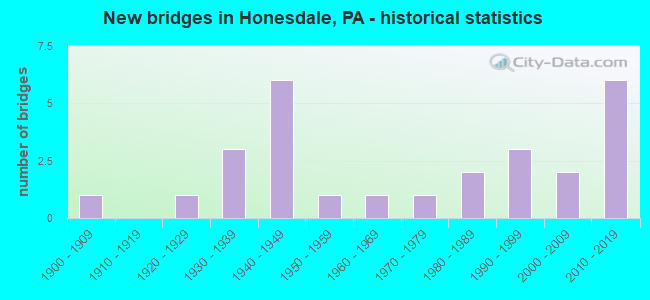
- New bridges - historical statistics
- 11900-1909
- 11920-1929
- 31930-1939
- 61940-1949
- 11950-1959
- 11960-1969
- 11970-1979
- 21980-1989
- 31990-1999
- 22000-2009
- 62010-2019

- Reconstructed bridges - Historical Statistics
- 11930-1939
- 01940-1949
- 01950-1959
- 01960-1969
- 01970-1979
- 21980-1989
- 11990-1999
- 12000-2009
- 12010-2019


- Bridge Condition - Deck
- 5.0%Excellent
- 20.0%Very good
- 55.0%Good
- 10.0%Fair
- 10.0%Poor

- Bridge Condition - Superstructure
- 13.6%Excellent
- 22.7%Very good
- 22.7%Good
- 9.1%Satisfactory
- 9.1%Fair
- 9.1%Poor
- 13.6%Serious

- Bridge Condition - Substructure
- 4.5%Excellent
- 4.5%Very good
- 40.9%Good
- 9.1%Satisfactory
- 18.2%Fair
- 13.6%Poor
- 4.5%Serious
- 4.5%Critical

- Bridge Condition - Channel
- 8.0%Very good
- 24.0%Good
- 20.0%Satisfactory
- 32.0%Fair
- 12.0%Poor
- 4.0%Serious

- Bridge Condition - Culverts
- 25.0%Excellent
- 25.0%Good
- 50.0%Fair
Find on map >> Show street view
Structure Number: 35424, Location: HONESDALE BORO JCT TR 191 (Lat: 41.576714, Lng: -75.257883), Route carried "on" structure: US 6, Year Built: 1944, Year Reconstructed: 1980, Status: Open, Structure Length: 3.90m (12.80ft), Average Daily Traffic: 11,931 (year 2022), Truck Traffic: 7%, Average Future Daily Traffic: 13,889 (year 2032), Design Load: HS 20, Features Intersected: LACKAWAXEN RIVER
Minimum Vertical Clearance: 30+ m (98+ ft), Kilometerpoint: 18.730, Lanes on structure: 3, Owner: State Highway Agency, Approaching Roadway Width: 14.6m (47.9ft), Material/Design: Prestressed concrete, Design/Construction: Box Beam or Girders - Multiple, Number Of Spans In Main Unit: 2, Length of Maximum Span: 18.9m (62.0ft), Curb or Sidewalk Widths: Left: 3.0m (9.8ft), Right: 3.0m (9.8ft), Curb-To-Curb Width: 14.6m (47.9ft), Out-to-Out Width: 21.3m (69.9ft)
Condition: Deck: Good, Superstructure: Good, Substructure: Satisfactory, Channel: Poor, Operating Rating: 90.7 metric tons, Method Used To Determine Operating Rating: Load Factor (LF), Inventory Rating: 39.9 metric tons, Method Used To Determine Inventory Rating: Load Factor (LF), Structural Evaluation: Equal to present minimum criteria, Deck Geometry: Somewhat better than minimum adequacy, Waterway Adequacy: Superior to present desirable criteria, Approach Roadway Alignment: Better than present minimum criteria, Length Of Structure Improvement: 3.90m (12.80ft), Designated Inspection Frequency: Every 24 months, Inspection Date: April 2021, Bridge Improvement Cost: $13,000, Roadway Improvement Cost: $39,000, Total Project Cost: $178,000, Deck Structure Type: Concrete Cast-file-Place, Wearing Surface/Protective System: Wearing Surface: Monolithic Concrete, Deck Protection: Epoxy Coated Reinforcing
Find on map >> Show street view
Structure Number: 35425, Location: HONESDALE BORO JCT TR 191 (Lat: 41.568628, Lng: -75.252033), Route carried "on" structure: US 6, Year Built: 1943, Year Reconstructed: 2008, Status: Open, Structure Length: 5.12m (16.80ft), Average Daily Traffic: 14,076 (year 2021), Truck Traffic: 5%, Average Future Daily Traffic: 21,538 (year 2032), Design Load: H 20, Features Intersected: LACKAWAXEN RIVER
Minimum Vertical Clearance: 30+ m (98+ ft), Kilometerpoint: 19.840, Lanes on structure: 4, Owner: State Highway Agency, Approaching Roadway Width: 17.7m (58.1ft), Skew: 1 degrees, Material/Design: Prestressed concrete, Design/Construction: Box Beam or Girders - Single/Spread, Number Of Spans In Main Unit: 3, Length of Maximum Span: 17.1m (56.1ft), Curb or Sidewalk Widths: Left: 1.5m (4.9ft), Right: 1.5m (4.9ft), Curb-To-Curb Width: 17.7m (58.1ft), Out-to-Out Width: 21.3m (69.9ft)
Condition: Deck: Good, Superstructure: Very good, Substructure: Good, Channel: Fair, Operating Rating: 95.3 metric tons, Method Used To Determine Operating Rating: Load Factor (LF), Inventory Rating: 42.6 metric tons, Method Used To Determine Inventory Rating: Load Factor (LF), Structural Evaluation: Better than present minimum criteria, Deck Geometry: Somewhat better than minimum adequacy, Waterway Adequacy: Equal to present desirable criteria, Approach Roadway Alignment: Better than present minimum criteria, Length Of Structure Improvement: 5.10m (16.73ft), Designated Inspection Frequency: Every 24 months, Inspection Date: May 2021, Bridge Improvement Cost: $31,000, Roadway Improvement Cost: $100,000, Total Project Cost: $422,000, Deck Structure Type: Concrete Cast-file-Place, Wearing Surface/Protective System: Wearing Surface: Epoxy Overlay, Deck Protection: Epoxy Coated Reinforcing
Find on map >> Show street view
Structure Number: 35426, Location: HONESDALE BO 140'E SR2007 (Lat: 41.561181, Lng: -75.245300), Route carried "on" structure: US 6, Year Built: 1936, Status: Open, Structure Length: 0.79m (2.59ft), Average Daily Traffic: 15,410 (year 2021), Truck Traffic: 7%, Average Future Daily Traffic: 23,818 (year 2032), Design Load: H 20, Features Intersected: CARLEY BROOK
Minimum Vertical Clearance: 30+ m (98+ ft), Kilometerpoint: 20.978, Lanes on structure: 3, Owner: State Highway Agency, Approaching Roadway Width: 12.2m (40.0ft), Material/Design: Concrete, Design/Construction: Culvert, Number Of Spans In Main Unit: 1, Length of Maximum Span: 7.9m (25.9ft)
Condition: Channel: Satisfactory, Culverts: Fair, Operating Rating: 49.0 metric tons, Method Used To Determine Operating Rating: Field evaluation and documented engineering judgment, Inventory Rating: 32.7 metric tons, Method Used To Determine Inventory Rating: Field evaluation and documented engineering judgment, Structural Evaluation: Somewhat better than minimum adequacy, Waterway Adequacy: Equal to present desirable criteria, Approach Roadway Alignment: Equal to present desirable criteria, Length Of Structure Improvement: 0.80m (2.62ft), Designated Inspection Frequency: Every 24 months, Inspection Date: March 2021, Bridge Improvement Cost: $17,000, Roadway Improvement Cost: $100,000, Total Project Cost: $231,000
Find on map >> Show street view
Structure Number: 35463, Location: CHERRY RG TP .1M S SR3024 (Lat: 41.509081, Lng: -75.288081), Route carried "on" structure: State highway 191, Year Built: 1943, Year Reconstructed: 1985, Status: Open, Structure Length: 12.25m (40.19ft), Average Daily Traffic: 3,697 (year 2021), Truck Traffic: 6%, Average Future Daily Traffic: 4,806 (year 2032), Design Load: H 20, Features Intersected: MIDDLE CR & ABANDONED RR
Minimum Vertical Clearance: 30+ m (98+ ft), Kilometerpoint: 37.234, Lanes on structure: 2, Base Highway Network: Yes, Owner: State Highway Agency, Approaching Roadway Width: 9.1m (29.9ft), Material/Design: Steel continuous, Design/Construction: Stringer/Multi-beam, Number Of Spans In Main Unit: 6, Length of Maximum Span: 21.6m (70.9ft), Curb or Sidewalk Widths: Left: 0.2m (0.7ft), Right: 0.2m (0.7ft), Curb-To-Curb Width: 10.1m (33.1ft), Out-to-Out Width: 11.6m (38.1ft)
Condition: Deck: Good, Superstructure: Satisfactory, Substructure: Poor, Channel: Good, Operating Rating: 98.0 metric tons, Method Used To Determine Operating Rating: Load Factor (LF), Inventory Rating: 59.0 metric tons, Method Used To Determine Inventory Rating: Load Factor (LF), Structural Evaluation: Meets minimum limits, Deck Geometry: Meets minimum limits, Waterway Adequacy: Superior to present desirable criteria, Approach Roadway Alignment: Equal to present desirable criteria, Length Of Structure Improvement: 13.20m (43.31ft), Designated Inspection Frequency: Every 24 months, Inspection Date: March 2021, Deck Structure Type: Concrete Cast-file-Place, Wearing Surface/Protective System: Wearing Surface: Monolithic Concrete, Deck Protection: Epoxy Coated Reinforcing
Find on map >> Show street view
Structure Number: 35469, Location: HONESDALE BO @ JCT TR 670 (Lat: 41.585653, Lng: -75.261169), Route carried "on" structure: State highway 191, Year Built: 1966, Year Reconstructed: 2018, Status: Open, Structure Length: 3.35m (10.99ft), Average Daily Traffic: 3,553 (year 2020), Truck Traffic: 9%, Average Future Daily Traffic: 6,653 (year 2032), Design Load: HS 20, Features Intersected: DYBERRY CREEK
Minimum Vertical Clearance: 30+ m (98+ ft), Kilometerpoint: 46.111, Lanes on structure: 2, Owner: State Highway Agency, Approaching Roadway Width: 10.1m (33.1ft), Skew: 6 degrees, Material/Design: Prestressed concrete, Design/Construction: Stringer/Multi-beam, Number Of Spans In Main Unit: 2, Length of Maximum Span: 15.8m (51.8ft), Curb or Sidewalk Widths: Left: 0.5m (1.6ft), Right: 1.5m (4.9ft), Curb-To-Curb Width: 10.1m (33.1ft), Out-to-Out Width: 12.8m (42.0ft)
Condition: Deck: Very good, Superstructure: Satisfactory, Substructure: Satisfactory, Channel: Fair, Operating Rating: 61.7 metric tons, Method Used To Determine Operating Rating: Load Factor (LF), Inventory Rating: 36.3 metric tons, Method Used To Determine Inventory Rating: Load Factor (LF), Structural Evaluation: Equal to present minimum criteria, Deck Geometry: Meets minimum limits, Waterway Adequacy: Equal to present desirable criteria, Approach Roadway Alignment: Better than present minimum criteria, Length Of Structure Improvement: 3.50m (11.48ft), Designated Inspection Frequency: Every 24 months, Inspection Date: April 2021, Bridge Improvement Cost: $41,000, Roadway Improvement Cost: $121,000, Total Project Cost: $555,000, Deck Structure Type: Concrete Cast-file-Place, Wearing Surface/Protective System: Wearing Surface: Epoxy Overlay, Deck Protection: Epoxy Coated Reinforcing
Find on map >> Show street view
Structure Number: 35576, Location: HONESDALE BO .7M N SR1005 (Lat: 41.593719, Lng: -75.246928), Route carried "on" structure: State highway , Year Built: 1974, Status: Open, Structure Length: 2.83m (9.28ft), Average Daily Traffic: 582 (year 2022), Truck Traffic: 8%, Average Future Daily Traffic: 728 (year 2032), Design Load: HS 20, Features Intersected: CARLEY BROOK, Facility Carried by Structure: SR 1001
Minimum Vertical Clearance: 30+ m (98+ ft), Kilometerpoint: 2.900, Lanes on structure: 2, Owner: State Highway Agency, Approaching Roadway Width: 7.6m (24.9ft), Skew: 3 degrees, Material/Design: Prestressed concrete, Design/Construction: Box Beam or Girders - Single/Spread, Number Of Spans In Main Unit: 2, Length of Maximum Span: 13.7m (44.9ft), Curb or Sidewalk Widths: Left: 0.2m (0.7ft), Right: 0.2m (0.7ft), Curb-To-Curb Width: 13.4m (44.0ft), Out-to-Out Width: 14.6m (47.9ft)
Condition: Deck: Good, Superstructure: Good, Substructure: Fair, Channel: Poor, Operating Rating: 48.1 metric tons, Method Used To Determine Operating Rating: Load Factor (LF), Inventory Rating: 29.0 metric tons, Method Used To Determine Inventory Rating: Load Factor (LF), Structural Evaluation: Somewhat better than minimum adequacy, Deck Geometry: Superior to present desirable criteria, Waterway Adequacy: Better than present minimum criteria, Approach Roadway Alignment: Equal to present desirable criteria, Length Of Structure Improvement: 3.60m (11.81ft), Designated Inspection Frequency: Every 24 months, Underwater Inspection Frequency: Every 24 months, Inspection Date: June 2021, Underwater Inspection Date: August 2021, Deck Structure Type: Concrete Cast-file-Place, Wearing Surface/Protective System: Wearing Surface: Latex Concrete
Find on map >> Show street view
Structure Number: 35577, Location: BERLIN TWP @ JCT SR 1010 (Lat: 41.603994, Lng: -75.242394), Route carried "on" structure: State highway , Year Built: 1943, Status: Open, Structure Length: 0.64m (2.10ft), Average Daily Traffic: 582 (year 2022), Truck Traffic: 8%, Average Future Daily Traffic: 728 (year 2032), Design Load: H 20, Features Intersected: CARLEY BROOK, Facility Carried by Structure: SR 1001
Minimum Vertical Clearance: 30+ m (98+ ft), Kilometerpoint: 4.125, Lanes on structure: 2, Owner: State Highway Agency, Approaching Roadway Width: 6.1m (20.0ft), Skew: 1 degrees, Material/Design: Concrete, Design/Construction: Arch - Deck, Number Of Spans In Main Unit: 1, Length of Maximum Span: 6.4m (21.0ft), Curb or Sidewalk Widths: Left: 0.2m (0.7ft), Right: 0.2m (0.7ft), Curb-To-Curb Width: 8.2m (26.9ft), Out-to-Out Width: 9.4m (30.8ft)
Condition: Superstructure: Fair, Substructure: Fair, Channel: Fair, Operating Rating: 49.0 metric tons, Method Used To Determine Operating Rating: Field evaluation and documented engineering judgment, Inventory Rating: 32.7 metric tons, Method Used To Determine Inventory Rating: Field evaluation and documented engineering judgment, Structural Evaluation: Somewhat better than minimum adequacy, Deck Geometry: Somewhat better than minimum adequacy, Waterway Adequacy: Superior to present desirable criteria, Approach Roadway Alignment: Equal to present desirable criteria, Length Of Structure Improvement: 0.60m (1.97ft), Designated Inspection Frequency: Every 24 months, Inspection Date: April 2021, Bridge Improvement Cost: $13,000, Roadway Improvement Cost: $100,000, Total Project Cost: $177,000
Find on map >> Show street view
Structure Number: 35578, Location: OREGON TWP 1.8M N SR 1010 (Lat: 41.628083, Lng: -75.235197), Route carried "on" structure: State highway , Year Built: 1943, Status: Open, Structure Length: 0.64m (2.10ft), Average Daily Traffic: 582 (year 2022), Truck Traffic: 8%, Average Future Daily Traffic: 728 (year 2032), Design Load: HS 20, Features Intersected: CARLEY BROOK, Facility Carried by Structure: SR 1001 CARLEY BK
Minimum Vertical Clearance: 30+ m (98+ ft), Kilometerpoint: 6.986, Lanes on structure: 2, Owner: State Highway Agency, Approaching Roadway Width: 5.2m (17.1ft), Skew: 2 degrees, Material/Design: Concrete, Design/Construction: Culvert, Number Of Spans In Main Unit: 1, Length of Maximum Span: 6.4m (21.0ft)
Condition: Channel: Fair, Culverts: Fair, Operating Rating: 49.0 metric tons, Method Used To Determine Operating Rating: Field evaluation and documented engineering judgment, Inventory Rating: 32.7 metric tons, Method Used To Determine Inventory Rating: Field evaluation and documented engineering judgment, Structural Evaluation: Somewhat better than minimum adequacy, Waterway Adequacy: Equal to present desirable criteria, Approach Roadway Alignment: Equal to present desirable criteria, Length Of Structure Improvement: 0.80m (2.62ft), Designated Inspection Frequency: Every 24 months, Inspection Date: April 2021
Find on map >> Show street view
Structure Number: 35594, Location: HONESDLE BO 200'E SR 1001 (Lat: 41.584986, Lng: -75.246358), Route carried "on" structure: State highway , Year Built: 1984, Status: Open, Structure Length: 0.88m (2.89ft), Average Daily Traffic: 1,404 (year 2022), Truck Traffic: 6%, Average Future Daily Traffic: 1,877 (year 2032), Features Intersected: OUTLET OF BUNNELLS POND, Facility Carried by Structure: SR 1005
Minimum Vertical Clearance: 30+ m (98+ ft), Kilometerpoint: 0.000, Lanes on structure: 2, Owner: State Highway Agency, Approaching Roadway Width: 10.1m (33.1ft), Material/Design: Prestressed concrete, Design/Construction: Box Beam or Girders - Multiple, Number Of Spans In Main Unit: 1, Length of Maximum Span: 8.5m (27.9ft), Curb or Sidewalk Widths: Left: 0.2m (0.7ft), Right: 0.2m (0.7ft), Curb-To-Curb Width: 10.0m (32.8ft), Out-to-Out Width: 11.1m (36.4ft)
Condition: Deck: Good, Superstructure: Serious, Substructure: Good, Channel: Satisfactory, Operating Rating: 59.0 metric tons, Method Used To Determine Operating Rating: Load Factor (LF), Inventory Rating: 35.4 metric tons, Method Used To Determine Inventory Rating: Load Factor (LF), Structural Evaluation: High priority of corrective action, Deck Geometry: Somewhat better than minimum adequacy, Waterway Adequacy: Equal to present desirable criteria, Approach Roadway Alignment: Equal to present desirable criteria, Length Of Structure Improvement: 0.90m (2.95ft), Designated Inspection Frequency: Every 24 months, Other Special Inspection Frequency: Every 6 months, Inspection Date: June 2021, Other Special Inspection Date: June 2021, Deck Structure Type: Other, Wearing Surface/Protective System: Wearing Surface: Bituminous, Membrane: Preformed Fabric
Find on map >> Show street view
Structure Number: 35653, Location: HONESDALE BORO .2M E TR 6 (Lat: 41.563717, Lng: -75.242753), Route carried "on" structure: State highway , Year Built: 1909, Status: Open, Structure Length: 0.73m (2.40ft), Average Daily Traffic: 304 (year 2020), Truck Traffic: 9%, Average Future Daily Traffic: 663 (year 2032), Features Intersected: CARLEY BROOK, Facility Carried by Structure: SR 2007
Minimum Vertical Clearance: 30+ m (98+ ft), Kilometerpoint: 0.000, Lanes on structure: 1, Owner: State Highway Agency, Approaching Roadway Width: 4.9m (16.1ft), Material/Design: Masonry, Design/Construction: Arch - Deck, Number Of Spans In Main Unit: 1, Length of Maximum Span: 7.3m (24.0ft), Curb-To-Curb Width: 4.7m (15.4ft), Out-to-Out Width: 5.6m (18.4ft)
Condition: Superstructure: Serious, Substructure: Serious, Channel: Fair, Operating Rating: 42.6 metric tons, Method Used To Determine Operating Rating: Field evaluation and documented engineering judgment, Inventory Rating: 21.8 metric tons, Method Used To Determine Inventory Rating: Field evaluation and documented engineering judgment, Structural Evaluation: High priority of corrective action, Deck Geometry: High priority of replacement, Waterway Adequacy: Superior to present desirable criteria, Approach Roadway Alignment: Equal to present desirable criteria, Length Of Structure Improvement: 0.70m (2.30ft), Designated Inspection Frequency: Every 24 months, Other Special Inspection Frequency: Every 6 months, Inspection Date: March 2021, Other Special Inspection Date: September 2021, Bridge Improvement Cost: $27,000, Roadway Improvement Cost: $178,000, Total Project Cost: $363,000
Find on map >> Show street view
Structure Number: 35655, Location: HONESDALE BO .1M E SR1001 (Lat: 41.579336, Lng: -75.246528), Route carried "on" structure: State highway , Year Built: 1930, Status: Posted for load, Structure Length: 0.88m (2.89ft), Average Daily Traffic: 38 (year 2018), Truck Traffic: 5%, Average Future Daily Traffic: 83 (year 2032), Features Intersected: CARLEY BROOK, Facility Carried by Structure: SR 2008 BATES RD
Minimum Vertical Clearance: 30+ m (98+ ft), Kilometerpoint: 0.000, Lanes on structure: 1, Owner: State Highway Agency, Approaching Roadway Width: 3.7m (12.1ft), Material/Design: Steel, Design/Construction: Stringer/Multi-beam, Number Of Spans In Main Unit: 1, Length of Maximum Span: 8.2m (26.9ft), Curb-To-Curb Width: 4.0m (13.1ft), Out-to-Out Width: 4.6m (15.1ft)
Condition: Deck: Poor, Superstructure: Poor, Substructure: Fair, Channel: Poor, Operating Rating: 40.8 metric tons, Method Used To Determine Operating Rating: Load Factor (LF), Inventory Rating: 24.5 metric tons, Method Used To Determine Inventory Rating: Load Factor (LF), Structural Evaluation: Meets minimum limits, Deck Geometry: Somewhat better than minimum adequacy, Waterway Adequacy: Equal to present minimum criteria, Approach Roadway Alignment: Equal to present minimum criteria, Bridge Posting: Required (Relationship of Operating Rating to Maximum Legal Load: 10.0 - 19.9% below), Length Of Structure Improvement: 1.10m (3.61ft), Designated Inspection Frequency: Every 24 months, Other Special Inspection Frequency: Every 12 months, Inspection Date: October 2021, Other Special Inspection Date: October 2021, Bridge Improvement Cost: $28,000, Roadway Improvement Cost: $139,000, Total Project Cost: $383,000, Deck Structure Type: Concrete Cast-file-Place, Wearing Surface/Protective System: Wearing Surface: Bituminous
Find on map >> Show street view
Structure Number: 35656, Location: BERLIN TWP .2 M S SR 1005 (Lat: 41.588294, Lng: -75.225508), Route carried "on" structure: State highway , Year Built: 1988, Status: Open, Structure Length: 0.67m (2.20ft), Average Daily Traffic: 661 (year 2022), Truck Traffic: 4%, Average Future Daily Traffic: 1,150 (year 2032), Design Load: HS 25 or greater, Features Intersected: TRIB TO HOLBERT CREEK, Facility Carried by Structure: SR 2009
Minimum Vertical Clearance: 30+ m (98+ ft), Kilometerpoint: 4.210, Lanes on structure: 2, Owner: State Highway Agency, Approaching Roadway Width: 7.3m (24.0ft), Skew: 1 degrees, Material/Design: Concrete, Design/Construction: Slab, Number Of Spans In Main Unit: 1, Length of Maximum Span: 6.4m (21.0ft), Curb-To-Curb Width: 7.3m (24.0ft), Out-to-Out Width: 8.5m (27.9ft)
Condition: Deck: Good, Superstructure: Good, Substructure: Critical, Channel: Serious, Operating Rating: 75.3 metric tons, Method Used To Determine Operating Rating: Load Factor (LF), Inventory Rating: 44.5 metric tons, Method Used To Determine Inventory Rating: Load Factor (LF), Structural Evaluation: High priority of replacement, Deck Geometry: Meets minimum limits, Waterway Adequacy: Somewhat better than minimum adequacy, Approach Roadway Alignment: Equal to present desirable criteria, Length Of Structure Improvement: 1.30m (4.27ft), Designated Inspection Frequency: Every 24 months, Underwater Inspection Frequency: Every 24 months, Other Special Inspection Frequency: Every 6 months, Inspection Date: May 2021, Underwater Inspection Date: September 2021, Other Special Inspection Date: May 2021, Wearing Surface/Protective System: Wearing Surface: Bituminous
Find on map >> Show street view
Structure Number: 35703, Location: CHERY RDG TP .5M E SR3039 (Lat: 41.512942, Lng: -75.294481), Route carried "on" structure: State highway , Year Built: 1934, Status: Posted for load, Structure Length: 0.67m (2.20ft), Average Daily Traffic: 231 (year 2022), Truck Traffic: 9%, Average Future Daily Traffic: 317 (year 2032), Design Load: HS 20, Features Intersected: COLLINS BROOK, Facility Carried by Structure: SR3024 MIDDLE CRK
Minimum Vertical Clearance: 30+ m (98+ ft), Kilometerpoint: 9.806, Lanes on structure: 2, Owner: State Highway Agency, Approaching Roadway Width: 5.8m (19.0ft), Material/Design: Concrete, Design/Construction: Slab, Number Of Spans In Main Unit: 1, Length of Maximum Span: 6.1m (20.0ft), Curb or Sidewalk Widths: Left: 0.1m (0.3ft), Right: 0.1m (0.3ft), Curb-To-Curb Width: 7.0m (23.0ft), Out-to-Out Width: 7.9m (25.9ft)
Condition: Deck: Fair, Superstructure: Fair, Substructure: Fair, Channel: Satisfactory, Operating Rating: 36.3 metric tons, Method Used To Determine Operating Rating: Load Factor (LF), Inventory Rating: 21.8 metric tons, Method Used To Determine Inventory Rating: Load Factor (LF), Structural Evaluation: Somewhat better than minimum adequacy, Deck Geometry: Meets minimum limits, Waterway Adequacy: Equal to present desirable criteria, Approach Roadway Alignment: Equal to present desirable criteria, Bridge Posting: Required (Relationship of Operating Rating to Maximum Legal Load: 20.0 - 29.9% below), Length Of Structure Improvement: 0.70m (2.30ft), Designated Inspection Frequency: Every 24 months, Other Special Inspection Frequency: Every 12 months, Inspection Date: November 2019, Other Special Inspection Date: November 2020, Bridge Improvement Cost: $20,000, Roadway Improvement Cost: $159,000, Total Project Cost: $272,000, Wearing Surface/Protective System: Wearing Surface: Bituminous
Find on map >> Show street view
Structure Number: 35718, Location: CHERRY RIDGE .5 M S TR191 (Lat: 41.505819, Lng: -75.275956), Route carried "on" structure: State highway , Year Built: 1920, Year Reconstructed: 1943, Status: Posted for load, Structure Length: 2.26m (7.41ft), Average Daily Traffic: 954 (year 2022), Truck Traffic: 6%, Average Future Daily Traffic: 1,250 (year 2032), Design Load: HS 20, Features Intersected: MIDDLE CREEK, Facility Carried by Structure: SR3031 HOADLEYS RD
Minimum Vertical Clearance: 30+ m (98+ ft), Kilometerpoint: 6.796, Lanes on structure: 2, Owner: State Highway Agency, Approaching Roadway Width: 6.4m (21.0ft), Material/Design: Steel, Design/Construction: Girder and Floorbeam System, Number Of Spans In Main Unit: 1, Length of Maximum Span: 21.3m (69.9ft), Curb or Sidewalk Widths: Left: 0.3m (1.0ft), Right: 0.3m (1.0ft), Curb-To-Curb Width: 6.7m (22.0ft), Out-to-Out Width: 7.3m (24.0ft)
Condition: Deck: Fair, Superstructure: Serious, Substructure: Poor, Channel: Fair, Operating Rating: 17.2 metric tons, Method Used To Determine Operating Rating: Load Factor (LF), Inventory Rating: 10.9 metric tons, Method Used To Determine Inventory Rating: Load Factor (LF), Structural Evaluation: High priority of replacement, Deck Geometry: Meets minimum limits, Waterway Adequacy: Better than present minimum criteria, Approach Roadway Alignment: Equal to present minimum criteria, Bridge Posting: Required (Relationship of Operating Rating to Maximum Legal Load: > 39.9% below), Length Of Structure Improvement: 3.00m (9.84ft), Designated Inspection Frequency: Every 24 months, Critical Feature Inspection Frequency: Every 6 months, Other Special Inspection Frequency: Every 6 months, Inspection Date: May 2021, Critical Feature Inspection Date: May 2021, Other Special Inspection Date: May 2021, Bridge Improvement Cost: $75,000, Roadway Improvement Cost: $350,000, Total Project Cost: $1,016,000, Deck Structure Type: Concrete Cast-file-Place, Wearing Surface/Protective System: Wearing Surface: Bituminous
Find on map >> Show street view
Structure Number: 35729, Location: TEXAS TWP 300' S SR 3032 (Lat: 41.576833, Lng: -75.279881), Route carried "on" structure: State highway , Year Built: 1994, Status: Open, Structure Length: 5.49m (18.01ft), Average Daily Traffic: 206 (year 2022), Truck Traffic: 5%, Average Future Daily Traffic: 542 (year 2032), Design Load: HS 25 or greater, Features Intersected: LACKAWAXEN RIVER, Facility Carried by Structure: SR 3041
Minimum Vertical Clearance: 30+ m (98+ ft), Kilometerpoint: 3.827, Lanes on structure: 2, Owner: State Highway Agency, Approaching Roadway Width: 10.4m (34.1ft), Material/Design: Steel, Design/Construction: Stringer/Multi-beam, Number Of Spans In Main Unit: 1, Length of Maximum Span: 53.3m (174.9ft), Curb or Sidewalk Widths: Left: 0.2m (0.7ft), Right: 0.2m (0.7ft), Curb-To-Curb Width: 9.9m (32.5ft), Out-to-Out Width: 11.0m (36.1ft)
Condition: Deck: Good, Superstructure: Good, Substructure: Good, Channel: Good, Operating Rating: 91.6 metric tons, Method Used To Determine Operating Rating: Load Factor (LF), Inventory Rating: 55.3 metric tons, Method Used To Determine Inventory Rating: Load Factor (LF), Structural Evaluation: Better than present minimum criteria, Deck Geometry: Better than present minimum criteria, Waterway Adequacy: Superior to present desirable criteria, Approach Roadway Alignment: Equal to present minimum criteria, Length Of Structure Improvement: 6.30m (20.67ft), Designated Inspection Frequency: Every 48 months, Inspection Date: March 2021, Deck Structure Type: Concrete Cast-file-Place, Wearing Surface/Protective System: Wearing Surface: Monolithic Concrete, Deck Protection: Epoxy Coated Reinforcing
Find on map >> Show street view
Structure Number: 35773, Location: HONESDALE BOR .1 M E TR 6 (Lat: 41.578247, Lng: -75.254617), Route carried "on" structure: State highway , Year Built: 1997, Status: Open, Structure Length: 2.50m (8.20ft), Average Daily Traffic: 1,196 (year 2022), Truck Traffic: 2%, Average Future Daily Traffic: 1,537 (year 2032), Design Load: HS 25 or greater, Features Intersected: DYBERRY CREEK, Facility Carried by Structure: SR 4015 PARK ST
Minimum Vertical Clearance: 30+ m (98+ ft), Kilometerpoint: 2.882, Lanes on structure: 2, Owner: State Highway Agency, Approaching Roadway Width: 8.2m (26.9ft), Skew: 1 degrees, Material/Design: Prestressed concrete, Design/Construction: Box Beam or Girders - Multiple, Number Of Spans In Main Unit: 1, Length of Maximum Span: 24.4m (80.1ft), Curb or Sidewalk Widths: Left: 0.2m (0.7ft), Right: 1.4m (4.6ft), Curb-To-Curb Width: 8.7m (28.5ft), Out-to-Out Width: 11.1m (36.4ft)
Condition: Deck: Good, Superstructure: Good, Substructure: Good, Channel: Satisfactory, Inventory Rating: 29.0 metric tons, Method Used To Determine Inventory Rating: Load Factor (LF), Structural Evaluation: Better than present minimum criteria, Deck Geometry: Somewhat better than minimum adequacy, Waterway Adequacy: Superior to present desirable criteria, Approach Roadway Alignment: Better than present minimum criteria, Length Of Structure Improvement: 3.20m (10.50ft), Designated Inspection Frequency: Every 24 months, Inspection Date: May 2021, Deck Structure Type: Concrete Cast-file-Place, Wearing Surface/Protective System: Wearing Surface: Monolithic Concrete, Deck Protection: Epoxy Coated Reinforcing
Find on map >> Show street view
Structure Number: 35863, Location: CARLEY BROOK (Lat: 41.615231, Lng: -75.239853), Route carried "on" structure: City street , Year Built: 1990, Status: Open, Structure Length: 1.10m (3.61ft), Average Daily Traffic: 65 (year 1998), Average Future Daily Traffic: 60 (year 2032), Design Load: HS 25 or greater, Features Intersected: CARLEY BROOK, Facility Carried by Structure: TWP RTE T-469
Minimum Vertical Clearance: 30+ m (98+ ft), Kilometerpoint: 0.000, Lanes on structure: 2, Owner: County Highway Agency, Approaching Roadway Width: 7.3m (24.0ft), Skew: 1 degrees, Material/Design: Prestressed concrete, Design/Construction: Box Beam or Girders - Multiple, Number Of Spans In Main Unit: 1, Length of Maximum Span: 10.7m (35.1ft), Curb or Sidewalk Widths: Left: 0.5m (1.6ft), Right: 0.5m (1.6ft), Curb-To-Curb Width: 7.6m (24.9ft), Out-to-Out Width: 8.6m (28.2ft)
Condition: Deck: Good, Superstructure: Excellent, Substructure: Good, Channel: Fair, Operating Rating: 60.8 metric tons, Method Used To Determine Operating Rating: Load Factor (LF), Inventory Rating: 28.1 metric tons, Method Used To Determine Inventory Rating: Load Factor (LF), Structural Evaluation: Better than present minimum criteria, Deck Geometry: Equal to present minimum criteria, Waterway Adequacy: Equal to present minimum criteria, Approach Roadway Alignment: Equal to present desirable criteria, Length Of Structure Improvement: 1.20m (3.94ft), Designated Inspection Frequency: Every 24 months, Inspection Date: July 2019, Bridge Improvement Cost: $21,000, Roadway Improvement Cost: $62,000, Total Project Cost: $285,000, Deck Structure Type: Concrete Cast-file-Place, Wearing Surface/Protective System: Wearing Surface: Monolithic Concrete, Deck Protection: Epoxy Coated Reinforcing
Find on map >> Show street view
Structure Number: 35864, Location: 2000' NORTH OF SR 1001 (Lat: 41.649964, Lng: -75.221847), Route carried "on" structure: City street , Year Built: 1956, Status: Posted for load, Structure Length: 0.82m (2.69ft), Average Daily Traffic: 100 (year 2011), Truck Traffic: 5%, Average Future Daily Traffic: 130 (year 2031), Features Intersected: CARLEY BROOK, Facility Carried by Structure: SPRY ROAD
Minimum Vertical Clearance: 30+ m (98+ ft), Kilometerpoint: 0.000, Lanes on structure: 2, Owner: Town or Township Highway Agency, Approaching Roadway Width: 4.3m (14.1ft), Skew: 4 degrees, Material/Design: Prestressed concrete, Design/Construction: Box Beam or Girders - Multiple, Number Of Spans In Main Unit: 1, Length of Maximum Span: 7.6m (24.9ft), Curb or Sidewalk Widths: Left: 0.2m (0.7ft), Right: 0.2m (0.7ft), Curb-To-Curb Width: 7.0m (23.0ft), Out-to-Out Width: 7.4m (24.3ft)
Condition: Deck: Poor, Superstructure: Poor, Substructure: Poor, Channel: Fair, Operating Rating: 20.9 metric tons, Method Used To Determine Operating Rating: Load Factor (LF), Inventory Rating: 10.0 metric tons, Method Used To Determine Inventory Rating: Load Factor (LF), Structural Evaluation: High priority of corrective action, Deck Geometry: Somewhat better than minimum adequacy, Waterway Adequacy: Better than present minimum criteria, Approach Roadway Alignment: Equal to present desirable criteria, Bridge Posting: Required (Relationship of Operating Rating to Maximum Legal Load: > 39.9% below), Length Of Structure Improvement: 1.40m (4.59ft), Designated Inspection Frequency: Every 24 months, Other Special Inspection Frequency: Every 12 months, Inspection Date: October 2019, Other Special Inspection Date: October 2020, Bridge Improvement Cost: $6,000, Roadway Improvement Cost: $16,000, Total Project Cost: $75,000, Deck Structure Type: Other, Wearing Surface/Protective System: Wearing Surface: Gravel
Find on map >> Show street view
Structure Number: 35885, Location: Brown Street Honesdale (Lat: 41.562864, Lng: -75.247572), Route carried "on" structure: City street , Year Built: 1944, Year Reconstructed: 1999, Status: Open, Structure Length: 4.48m (14.70ft), Average Daily Traffic: 3,245 (year 2011), Truck Traffic: 5%, Average Future Daily Traffic: 3,500 (year 2018), Design Load: H 20, Features Intersected: LACKAWAXEN RIVER, Facility Carried by Structure: BROWN STREET
Minimum Vertical Clearance: 30+ m (98+ ft), Kilometerpoint: 0.000, Lanes on structure: 2, Owner: County Highway Agency, Approaching Roadway Width: 9.8m (32.2ft), Material/Design: Prestressed concrete, Design/Construction: Box Beam or Girders - Single/Spread, Number Of Spans In Main Unit: 3, Length of Maximum Span: 14.0m (45.9ft), Curb or Sidewalk Widths: Left: 1.5m (4.9ft), Right: 0.2m (0.7ft), Curb-To-Curb Width: 9.8m (32.2ft), Out-to-Out Width: 12.1m (39.7ft)
Condition: Deck: Very good, Superstructure: Very good, Substructure: Good, Channel: Good, Operating Rating: 59.0 metric tons, Method Used To Determine Operating Rating: Load Factor (LF), Inventory Rating: 37.2 metric tons, Method Used To Determine Inventory Rating: Load Factor (LF), Structural Evaluation: Better than present minimum criteria, Deck Geometry: Meets minimum limits, Waterway Adequacy: Equal to present desirable criteria, Approach Roadway Alignment: Equal to present desirable criteria, Length Of Structure Improvement: 4.50m (14.76ft), Designated Inspection Frequency: Every 24 months, Inspection Date: September 2019, Bridge Improvement Cost: $35,000, Roadway Improvement Cost: $103,000, Total Project Cost: $471,000, Deck Structure Type: Concrete Cast-file-Place, Wearing Surface/Protective System: Wearing Surface: Monolithic Concrete, Deck Protection: Epoxy Coated Reinforcing
Find on map >> Show street view
Structure Number: 41187, Location: TEXAS TWP .1 M W SR 2009 (Lat: 41.553769, Lng: -75.223506), Route carried "on" structure: US 6, Year Built: 2000, Status: Open, Structure Length: 0.79m (2.59ft), Average Daily Traffic: 12,668 (year 2021), Truck Traffic: 5%, Average Future Daily Traffic: 23,818 (year 2032), Design Load: HS 20, Features Intersected: HOLBERT CREEK
Minimum Vertical Clearance: 30+ m (98+ ft), Kilometerpoint: 23.150, Lanes on structure: 3, Owner: State Highway Agency, Approaching Roadway Width: 13.1m (43.0ft), Skew: 4 degrees, Material/Design: Concrete, Design/Construction: Culvert, Number Of Spans In Main Unit: 1, Length of Maximum Span: 7.9m (25.9ft), Curb or Sidewalk Widths: Left: 0.0m, Right: 0.1m (0.3ft)
Condition: Channel: Satisfactory, Culverts: Good, Operating Rating: 95.3 metric tons, Method Used To Determine Operating Rating: Load Factor (LF), Inventory Rating: 57.2 metric tons, Method Used To Determine Inventory Rating: Load Factor (LF), Structural Evaluation: Better than present minimum criteria, Waterway Adequacy: Equal to present desirable criteria, Approach Roadway Alignment: Equal to present desirable criteria, Length Of Structure Improvement: 1.40m (4.59ft), Designated Inspection Frequency: Every 48 months, Inspection Date: April 2021
Find on map >> Show street view
Structure Number: 45711, Location: HONESDALE BORO JCT 191 (Lat: 41.576972, Lng: -75.256953), Route carried "on" structure: US 6, Year Built: 2009, Status: Open, Structure Length: 4.08m (13.39ft), Average Daily Traffic: 12,292 (year 2022), Truck Traffic: 7%, Average Future Daily Traffic: 13,133 (year 2032), Design Load: HS 25 or greater, Features Intersected: LACKAWAXEN RIVER
Minimum Vertical Clearance: 30.18m (99.02ft), Kilometerpoint: 18.730, Lanes on structure: 2, Owner: State Highway Agency, Approaching Roadway Width: 10.4m (34.1ft), Material/Design: Prestressed concrete, Design/Construction: Box Beam or Girders - Single/Spread, Number Of Spans In Main Unit: 2, Length of Maximum Span: 19.5m (64.0ft), Curb or Sidewalk Widths: Left: 1.5m (4.9ft), Right: 1.5m (4.9ft), Curb-To-Curb Width: 10.2m (33.5ft), Out-to-Out Width: 12.6m (41.3ft)
Condition: Deck: Good, Superstructure: Very good, Substructure: Good, Channel: Very good, Inventory Rating: 50.8 metric tons, Method Used To Determine Inventory Rating: Load Factor (LF), Structural Evaluation: Better than present minimum criteria, Deck Geometry: Somewhat better than minimum adequacy, Waterway Adequacy: Superior to present desirable criteria, Approach Roadway Alignment: Equal to present minimum criteria, Designated Inspection Frequency: Every 48 months, Inspection Date: May 2021, Deck Structure Type: Concrete Cast-file-Place, Wearing Surface/Protective System: Wearing Surface: Epoxy Overlay, Deck Protection: Epoxy Coated Reinforcing
Find on map >> Show street view
Structure Number: 46389, Location: S. Tryon St. Honesdale (Lat: 41.562711, Lng: -75.243858), Route carried "on" structure: City street , Year Built: 2010, Status: Open, Structure Length: 1.01m (3.31ft), Average Daily Traffic: 107 (year 2008), Truck Traffic: 1%, Average Future Daily Traffic: 138 (year 2029), Design Load: HL 93, Features Intersected: CARLEY BROOK, Facility Carried by Structure: EAST TRYON STREET
Minimum Vertical Clearance: 30+ m (98+ ft), Kilometerpoint: 0.000, Lanes on structure: 2, Owner: County Highway Agency, Approaching Roadway Width: 7.3m (24.0ft), Skew: 1 degrees, Material/Design: Prestressed concrete, Design/Construction: Box Beam or Girders - Single/Spread, Number Of Spans In Main Unit: 1, Length of Maximum Span: 9.8m (32.2ft), Curb or Sidewalk Widths: Left: 1.7m (5.6ft), Right: 0.0m, Curb-To-Curb Width: 7.3m (24.0ft), Out-to-Out Width: 9.8m (32.2ft)
Condition: Deck: Very good, Superstructure: Very good, Substructure: Very good, Channel: Good, Operating Rating: 57.2 metric tons, Method Used To Determine Operating Rating: Load and Resistance Factor (LRFR), Inventory Rating: 43.5 metric tons, Method Used To Determine Inventory Rating: Load and Resistance Factor (LRFR), Structural Evaluation: Equal to present desirable criteria, Deck Geometry: Somewhat better than minimum adequacy, Waterway Adequacy: Equal to present desirable criteria, Approach Roadway Alignment: Equal to present desirable criteria, Designated Inspection Frequency: Every 24 months, Inspection Date: November 2020, Deck Structure Type: Corrugated Steel, Wearing Surface/Protective System: Wearing Surface: Monolithic Concrete, Deck Protection: Epoxy Coated Reinforcing
Find on map >> Show street view
Structure Number: 48671, Location: CHERRY RDGE TP OVER TR191 (Lat: 41.522197, Lng: -75.266919), Route carried "on" structure: State highway , Year Built: 2014, Status: Open, Structure Length: 1.43m (4.69ft), Average Daily Traffic: 2,418 (year 2022), Truck Traffic: 10%, Average Future Daily Traffic: 7,557 (year 2034), Design Load: HL 93, Features Intersected: SR 191 TR 191, Facility Carried by Structure: SR 3028 OWEGO TPK
Minimum Vertical Clearance: 30+ m (98+ ft), Kilometerpoint: 13.375, Lanes on structure: 2, Lanes under structure: 2, Owner: State Highway Agency, Approaching Roadway Width: 7.9m (25.9ft), Material/Design: Prestressed concrete, Design/Construction: Box Beam or Girders - Single/Spread, Number Of Spans In Main Unit: 1, Length of Maximum Span: 13.7m (44.9ft), Curb or Sidewalk Widths: Left: 0.2m (0.7ft), Right: 0.2m (0.7ft), Curb-To-Curb Width: 13.0m (42.7ft), Out-to-Out Width: 14.0m (45.9ft)
Condition: Deck: Good, Superstructure: Excellent, Substructure: Good, Operating Rating: 54.1 metric tons, Method Used To Determine Operating Rating: Assigned ratings based on Load and Resistance Factor Design (LRFD) reported by rating factor (RF) using HL93 loadings, Inventory Rating: 34.0 metric tons, Method Used To Determine Inventory Rating: Assigned ratings based on Load and Resistance Factor Design (LRFD) reported by rating factor (RF) using HL93 loadings, Structural Evaluation: Better than present minimum criteria, Deck Geometry: Equal to present minimum criteria, Underclear: Meets minimum limits, Approach Roadway Alignment: Equal to present desirable criteria, Designated Inspection Frequency: Every 48 months, Inspection Date: April 2021, Deck Structure Type: Concrete Cast-file-Place, Wearing Surface/Protective System: Wearing Surface: Monolithic Concrete, Deck Protection: Epoxy Coated Reinforcing
Find on map >> Show street view
Structure Number: 48672, Location: DYBERRY TWP JCT TR 191 (Lat: 41.599858, Lng: -75.266033), Route carried "on" structure: Spur State highway , Year Built: 2014, Status: Open, Structure Length: 1.86m (6.10ft), Average Daily Traffic: 246 (year 2021), Truck Traffic: 5%, Average Future Daily Traffic: 344 (year 2034), Design Load: HL 93, Features Intersected: DYBERRY CREEK, Facility Carried by Structure: SR 4006
Minimum Vertical Clearance: 30+ m (98+ ft), Kilometerpoint: 1.653, Lanes on structure: 2, Owner: State Highway Agency, Approaching Roadway Width: 10.7m (35.1ft), Skew: 2 degrees, Material/Design: Prestressed concrete, Design/Construction: Box Beam or Girders - Single/Spread, Number Of Spans In Main Unit: 1, Length of Maximum Span: 18.0m (59.1ft), Curb or Sidewalk Widths: Left: 0.2m (0.7ft), Right: 0.2m (0.7ft), Curb-To-Curb Width: 13.4m (44.0ft), Out-to-Out Width: 14.4m (47.2ft)
Condition: Deck: Very good, Superstructure: Very good, Substructure: Good, Channel: Good, Operating Rating: 48.6 metric tons, Method Used To Determine Operating Rating: Assigned ratings based on Load and Resistance Factor Design (LRFD) reported by rating factor (RF) using HL93 loadings, Inventory Rating: 36.0 metric tons, Method Used To Determine Inventory Rating: Assigned ratings based on Load and Resistance Factor Design (LRFD) reported by rating factor (RF) using HL93 loadings, Structural Evaluation: Better than present minimum criteria, Deck Geometry: Superior to present desirable criteria, Waterway Adequacy: Better than present minimum criteria, Approach Roadway Alignment: Better than present minimum criteria, Designated Inspection Frequency: Every 48 months, Inspection Date: July 2020, Deck Structure Type: Concrete Cast-file-Place, Wearing Surface/Protective System: Wearing Surface: Monolithic Concrete, Deck Protection: Epoxy Coated Reinforcing
Find on map >> Show street view
Structure Number: 53273, Location: BERLIN TWP @ JCT SR 2009 (Lat: 41.569594, Lng: -75.225339), Route carried "on" structure: State highway , Year Built: 2016, Status: Open, Structure Length: 1.58m (5.18ft), Average Daily Traffic: 304 (year 2020), Truck Traffic: 9%, Average Future Daily Traffic: 559 (year 2037), Design Load: HL 93, Features Intersected: HOLBERT CREEK, Facility Carried by Structure: Tryon St (SR 2007)
Minimum Vertical Clearance: 30+ m (98+ ft), Kilometerpoint: 1.511, Lanes on structure: 2, Owner: State Highway Agency, Maintenance Responsibility: Private, Approaching Roadway Width: 6.1m (20.0ft), Material/Design: Prestressed concrete, Design/Construction: Box Beam or Girders - Single/Spread, Number Of Spans In Main Unit: 1, Length of Maximum Span: 14.6m (47.9ft), Curb-To-Curb Width: 8.4m (27.6ft), Out-to-Out Width: 9.0m (29.5ft)
Condition: Deck: Excellent, Superstructure: Excellent, Substructure: Excellent, Channel: Very good, Operating Rating: 51.2 metric tons, Method Used To Determine Operating Rating: Assigned ratings based on Load and Resistance Factor Design (LRFD) reported by rating factor (RF) using HL93 loadings, Inventory Rating: 39.5 metric tons, Method Used To Determine Inventory Rating: Assigned ratings based on Load and Resistance Factor Design (LRFD) reported by rating factor (RF) using HL93 loadings, Structural Evaluation: Superior to present desirable criteria, Deck Geometry: Somewhat better than minimum adequacy, Waterway Adequacy: Better than present minimum criteria, Approach Roadway Alignment: Equal to present minimum criteria, Designated Inspection Frequency: Every 24 months, Inspection Date: May 2020, Deck Structure Type: Concrete Cast-file-Place, Wearing Surface/Protective System: Wearing Surface: Integral Concrete, Deck Protection: Epoxy Coated Reinforcing
Find on map >> Show street view
Structure Number: 5705, Location: ADJACENT TO SR 2009 (Lat: 41.555433, Lng: -75.223444), Route carried "on" structure: City street , Year Built: 2019, Status: Open, Structure Length: 0.67m (2.20ft), Average Daily Traffic: 250 (year 2013), Truck Traffic: 5%, Average Future Daily Traffic: 275 (year 2033), Design Load: HL 93, Features Intersected: HOLBERT CREEK, Facility Carried by Structure: OLD WILLOW AVENUE
Minimum Vertical Clearance: 30+ m (98+ ft), Kilometerpoint: 0.000, Lanes on structure: 2, Owner: Town or Township Highway Agency, Approaching Roadway Width: 7.3m (24.0ft), Skew: 9 degrees, Material/Design: Concrete, Design/Construction: Culvert, Number Of Spans In Main Unit: 1, Length of Maximum Span: 6.7m (22.0ft), Curb or Sidewalk Widths: Left: 0.2m (0.7ft), Right: 0.2m (0.7ft)
Condition: Channel: Good, Culverts: Excellent, Operating Rating: 38.9 metric tons, Method Used To Determine Operating Rating: Assigned ratings based on Load and Resistance Factor Design (LRFD) reported by rating factor (RF) using HL93 loadings, Inventory Rating: 32.4 metric tons, Method Used To Determine Inventory Rating: Assigned ratings based on Load and Resistance Factor Design (LRFD) reported by rating factor (RF) using HL93 loadings, Structural Evaluation: Equal to present desirable criteria, Waterway Adequacy: Superior to present desirable criteria, Approach Roadway Alignment: Equal to present desirable criteria, Designated Inspection Frequency: Every 24 months, Inspection Date: September 2019
Find on map >> Show street view
Structure Number: 48671, Location: CHERRY RDGE TP OVER TR191 (Lat: 41.522197, Lng: -75.266919), Route carried "under" structure: State highway 191, Year Built: 2014, Structure Length: 0. m, Average Daily Traffic: 5,298 (year 2021), Truck Traffic: 7%, Features Intersected: SR 191 TR 191, Facility Carried by Structure: SR 3028 OWEGO TPK
Minimum Vertical Clearance: 4.95m (16.24ft), Kilometerpoint: 39.258, Lanes on structure: 2, Lanes under structure: 2, Material/Design: Prestressed concrete, Design/Construction: Box Beam or Girders - Single/Spread, Length of Maximum Span: 13.7m (44.9ft)