Bridge Statistics for Hominy, Oklahoma (OK)
Condition, Traffic, Stress, Structural Evaluation, Project Costs
- National Bridge Inventory (NBI) Statistics
- 16Number of bridges
- 138ft / 41.9mTotal length
- $10,321,000Total costs
- 12,175Total average daily traffic
- 1,829Total average daily truck traffic
- 19,480Total future (year 2040) average daily traffic
- National Bridge Inventory (NBI) Registered Bridges for Hominy
- No street view available for this location
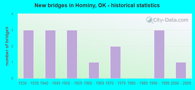
- New bridges - historical statistics
- 31930-1939
- 31940-1949
- 31950-1959
- 11960-1969
- 21970-1979
- 31990-1999
- 12000-2009

- Bridge Condition - Deck
- 44.4%Good
- 22.2%Fair
- 22.2%Poor
- 11.1%Serious

- Bridge Condition - Superstructure
- 44.4%Very good
- 11.1%Satisfactory
- 11.1%Fair
- 22.2%Poor
- 11.1%Serious

- Bridge Condition - Substructure
- 11.1%Very good
- 33.3%Good
- 11.1%Satisfactory
- 22.2%Fair
- 11.1%Poor
- 11.1%Serious

- Bridge Condition - Channel
- 25.0%Very good
- 12.5%Good
- 12.5%Satisfactory
- 37.5%Fair
- 12.5%Poor

- Bridge Condition - Culverts
- 42.9%Good
- 42.9%Satisfactory
- 14.3%Fair
Find on map >> Show street view
Structure Number: 4484, Location: 1MI. NW JCT OF HWY 20&99 (Lat: 36.418919, Lng: -96.407492), Route carried "on" structure: County highway N3700, Year Built: 1935, Status: Posted for load, Structure Length: 1.65m (5.41ft), Average Daily Traffic: 80 (year 2020), Truck Traffic: 10%, Average Future Daily Traffic: 128 (year 2040), Features Intersected: CREEK
Minimum Vertical Clearance: 30+ m (98+ ft), Kilometerpoint: 0.161, Lanes on structure: 2, Owner: County Highway Agency, Approaching Roadway Width: 6.9m (22.6ft), Material/Design: Steel, Design/Construction: Truss - Thru, Number Of Spans In Main Unit: 1, Length of Maximum Span: 15.8m (51.8ft), Curb or Sidewalk Widths: Left: 0.2m (0.7ft), Right: 0.2m (0.7ft), Curb-To-Curb Width: 5.1m (16.7ft), Out-to-Out Width: 5.4m (17.7ft)
Condition: Deck: Poor, Superstructure: Poor, Substructure: Satisfactory, Channel: Fair, Operating Rating: 15.2 metric tons, Method Used To Determine Operating Rating: Allowable Stress (AS), Inventory Rating: 4.7 metric tons, Method Used To Determine Inventory Rating: Allowable Stress (AS), Structural Evaluation: High priority of replacement, Deck Geometry: High priority of corrective action, Waterway Adequacy: Meets minimum limits, Approach Roadway Alignment: Equal to present minimum criteria, Bridge Posting: Required (Relationship of Operating Rating to Maximum Legal Load: > 39.9% below), Length Of Structure Improvement: 4.50m (14.76ft), Designated Inspection Frequency: Every 12 months, Critical Feature Inspection Frequency: Every 12 months, Other Special Inspection Frequency: Every 12 months, Inspection Date: May 2021, Critical Feature Inspection Date: May 2021, Other Special Inspection Date: October 2021, Bridge Improvement Cost: $230,000, Roadway Improvement Cost: $126,000, Total Project Cost: $366,000 ( Estimate for 2015), Deck Structure Type: Concrete Cast-file-Place, Wearing Surface/Protective System: Wearing Surface: Bituminous
Find on map >> Show street view
Structure Number: 6439, Location: 3N OF HOMINY (Lat: 36.477689, Lng: -96.407106), Route carried "on" structure: County highway 5755, Year Built: 1938, Status: Posted for load, Structure Length: 1.80m (5.91ft), Average Daily Traffic: 75 (year 2020), Truck Traffic: 10%, Average Future Daily Traffic: 120 (year 2040), Design Load: H 20, Features Intersected: CREEK
Minimum Vertical Clearance: 30+ m (98+ ft), Kilometerpoint: 1.609, Lanes on structure: 2, Owner: County Highway Agency, Approaching Roadway Width: 6.5m (21.3ft), Material/Design: Concrete continuous, Design/Construction: Slab, Number Of Spans In Main Unit: 3, Length of Maximum Span: 5.5m (18.0ft), Curb-To-Curb Width: 4.9m (16.1ft), Out-to-Out Width: 5.5m (18.0ft)
Condition: Deck: Serious, Superstructure: Serious, Substructure: Serious, Channel: Poor, Operating Rating: 4.9 metric tons, Method Used To Determine Operating Rating: Load Factor (LF), Inventory Rating: 2.9 metric tons, Method Used To Determine Inventory Rating: Load Factor (LF), Structural Evaluation: High priority of replacement, Deck Geometry: High priority of corrective action, Waterway Adequacy: High priority of replacement, Approach Roadway Alignment: High priority of corrective action, Bridge Posting: Required (Relationship of Operating Rating to Maximum Legal Load: > 39.9% below), Length Of Structure Improvement: 4.71m (15.45ft), Designated Inspection Frequency: Every 24 months, Other Special Inspection Frequency: Every 24 months, Inspection Date: March 2020, Other Special Inspection Date: April 2021, Bridge Improvement Cost: $241,000, Roadway Improvement Cost: $132,000, Total Project Cost: $383,000 ( Estimate for 2015), Deck Structure Type: Concrete Cast-file-Place, Wearing Surface/Protective System: Wearing Surface: Monolithic Concrete
Find on map >> Show street view
Structure Number: 7059, Location: 1.25N&.75W OF JCT 99 & 20 (Lat: 36.433983, Lng: -96.403942), Route carried "on" structure: County highway E0400, Year Built: 1939, Status: Open, Structure Length: 0.98m (3.22ft), Average Daily Traffic: 50 (year 2020), Truck Traffic: 10%, Average Future Daily Traffic: 80 (year 2040), Design Load: HS 20, Features Intersected: CREEK
Minimum Vertical Clearance: 30+ m (98+ ft), Kilometerpoint: 1.448, Lanes on structure: 2, Owner: County Highway Agency, Approaching Roadway Width: 4.9m (16.1ft), Material/Design: Concrete, Design/Construction: Culvert, Number Of Spans In Main Unit: 3, Length of Maximum Span: 3.0m (9.8ft), Curb-To-Curb Width: 7.3m (24.0ft), Out-to-Out Width: 7.9m (25.9ft)
Condition: Channel: Poor, Culverts: Satisfactory, Operating Rating: 53.6 metric tons, Method Used To Determine Operating Rating: Load Factor (LF), Inventory Rating: 32.2 metric tons, Method Used To Determine Inventory Rating: Load Factor (LF), Structural Evaluation: Equal to present minimum criteria, Deck Geometry: Equal to present minimum criteria, Waterway Adequacy: Somewhat better than minimum adequacy, Approach Roadway Alignment: Equal to present desirable criteria, Length Of Structure Improvement: 3.41m (11.19ft), Designated Inspection Frequency: Every 24 months, Inspection Date: March 2020, Bridge Improvement Cost: $100,000, Roadway Improvement Cost: $75,000, Total Project Cost: $225,000 ( Estimate for 2015), Deck Structure Type: Concrete Cast-file-Place, Wearing Surface/Protective System: Wearing Surface: Bituminous
Find on map >> Show street view
Structure Number: 8238, Location: 3.5 MI. NE OF HOMINY (Lat: 36.426886, Lng: -96.335658), Route carried "on" structure: County highway 5788C, Year Built: 1940, Status: Posted for load, Structure Length: 1.13m (3.71ft), Average Daily Traffic: 220 (year 2020), Truck Traffic: 15%, Average Future Daily Traffic: 352 (year 2040), Design Load: H 20, Features Intersected: CREEK
Minimum Vertical Clearance: 30+ m (98+ ft), Kilometerpoint: 5.309, Lanes on structure: 2, Owner: County Highway Agency, Approaching Roadway Width: 9.7m (31.8ft), Material/Design: Concrete, Design/Construction: Slab, Number Of Spans In Main Unit: 1, Length of Maximum Span: 10.7m (35.1ft), Curb-To-Curb Width: 7.9m (25.9ft), Out-to-Out Width: 7.9m (25.9ft)
Condition: Deck: Fair, Superstructure: Satisfactory, Substructure: Poor, Channel: Fair, Operating Rating: 5.8 metric tons, Method Used To Determine Operating Rating: Load Factor (LF), Inventory Rating: 3.5 metric tons, Method Used To Determine Inventory Rating: Load Factor (LF), Structural Evaluation: High priority of replacement, Deck Geometry: Somewhat better than minimum adequacy, Waterway Adequacy: Meets minimum limits, Approach Roadway Alignment: Equal to present minimum criteria, Bridge Posting: Required (Relationship of Operating Rating to Maximum Legal Load: > 39.9% below), Length Of Structure Improvement: 3.68m (12.07ft), Designated Inspection Frequency: Every 24 months, Inspection Date: March 2020, Bridge Improvement Cost: $188,000, Roadway Improvement Cost: $103,000, Total Project Cost: $298,000 ( Estimate for 2015), Deck Structure Type: Concrete Cast-file-Place, Wearing Surface/Protective System: Wearing Surface: Bituminous
Find on map >> Show street view
Structure Number: 899, Location: 2S&.75W OF JCT. 99&20 (Lat: 36.390586, Lng: -96.404147), Route carried "on" structure: County highway D3676, Year Built: 1940, Status: Posted for load, Structure Length: 1.25m (4.10ft), Average Daily Traffic: 300 (year 2020), Truck Traffic: 10%, Average Future Daily Traffic: 480 (year 2040), Features Intersected: BLACKBIRD CREEK
Minimum Vertical Clearance: 30+ m (98+ ft), Kilometerpoint: 7.401, Lanes on structure: 2, Owner: County Highway Agency, Approaching Roadway Width: 6.5m (21.3ft), Material/Design: Steel, Design/Construction: Stringer/Multi-beam, Number Of Spans In Main Unit: 1, Length of Maximum Span: 11.6m (38.1ft), Curb-To-Curb Width: 7.5m (24.6ft), Out-to-Out Width: 7.9m (25.9ft)
Condition: Deck: Poor, Superstructure: Poor, Substructure: Fair, Channel: Fair, Operating Rating: 28.8 metric tons, Method Used To Determine Operating Rating: Load Factor (LF), Inventory Rating: 17.3 metric tons, Method Used To Determine Inventory Rating: Load Factor (LF), Structural Evaluation: Meets minimum limits, Deck Geometry: Somewhat better than minimum adequacy, Waterway Adequacy: High priority of corrective action, Approach Roadway Alignment: Equal to present minimum criteria, Length Of Structure Improvement: 3.88m (12.73ft), Designated Inspection Frequency: Every 24 months, Inspection Date: March 2020, Bridge Improvement Cost: $99,000, Roadway Improvement Cost: $55,000, Total Project Cost: $225,000 ( Estimate for 2015), Deck Structure Type: Concrete Cast-file-Place, Wearing Surface/Protective System: Wearing Surface: Monolithic Concrete
Find on map >> Show street view
Structure Number: 9372, Location: .6 MI N ON BOOKER (Lat: 36.425353, Lng: -96.407486), Route carried "on" structure: County highway N3700, Year Built: 1940, Status: Posted for load, Structure Length: 2.80m (9.19ft), Average Daily Traffic: 80 (year 2020), Truck Traffic: 10%, Average Future Daily Traffic: 128 (year 2040), Features Intersected: CREEK
Minimum Vertical Clearance: 30+ m (98+ ft), Kilometerpoint: 0.966, Lanes on structure: 2, Owner: County Highway Agency, Approaching Roadway Width: 7.0m (23.0ft), Material/Design: Steel, Design/Construction: Truss - Thru, Number Of Spans In Main Unit: 1, Length of Maximum Span: 27.4m (89.9ft), Curb or Sidewalk Widths: Left: 0.2m (0.7ft), Right: 0.2m (0.7ft), Curb-To-Curb Width: 5.2m (17.1ft), Out-to-Out Width: 5.5m (18.0ft)
Condition: Deck: Fair, Superstructure: Fair, Substructure: Fair, Channel: Satisfactory, Operating Rating: 34.9 metric tons, Method Used To Determine Operating Rating: Allowable Stress (AS), Inventory Rating: 14.8 metric tons, Method Used To Determine Inventory Rating: Allowable Stress (AS), Structural Evaluation: Meets minimum limits, Deck Geometry: High priority of corrective action, Waterway Adequacy: Somewhat better than minimum adequacy, Approach Roadway Alignment: Equal to present minimum criteria, Bridge Posting: Required (Relationship of Operating Rating to Maximum Legal Load: 10.0 - 19.9% below), Length Of Structure Improvement: 6.03m (19.78ft), Designated Inspection Frequency: Every 24 months, Critical Feature Inspection Frequency: Every 24 months, Inspection Date: January 2021, Critical Feature Inspection Date: January 2021, Bridge Improvement Cost: $308,000, Roadway Improvement Cost: $169,000, Total Project Cost: $492,000 ( Estimate for 2016), Deck Structure Type: Concrete Cast-file-Place, Wearing Surface/Protective System: Wearing Surface: Bituminous
Find on map >> Show street view
Structure Number: 12575, Location: 0.5 MI. E. JCT. SH99 (Lat: 36.413397, Lng: -96.381831), Route carried "on" structure: State highway 20, Year Built: 1951, Status: Open, Structure Length: 1.43m (4.69ft), Average Daily Traffic: 2,400 (year 2020), Truck Traffic: 15%, Average Future Daily Traffic: 3,840 (year 2040), Design Load: HS 20, Features Intersected: BLACK BIRD CREEK
Minimum Vertical Clearance: 30+ m (98+ ft), Kilometerpoint: 0.708, Lanes on structure: 2, Owner: State Highway Agency, Approaching Roadway Width: 7.9m (25.9ft), Material/Design: Concrete, Design/Construction: Culvert, Number Of Spans In Main Unit: 3, Length of Maximum Span: 5.2m (17.1ft)
Condition: Channel: Good, Culverts: Satisfactory, Operating Rating: 44.5 metric tons, Method Used To Determine Operating Rating: Allowable Stress (AS), Inventory Rating: 32.7 metric tons, Method Used To Determine Inventory Rating: Allowable Stress (AS), Structural Evaluation: Equal to present minimum criteria, Waterway Adequacy: Better than present minimum criteria, Approach Roadway Alignment: Equal to present desirable criteria, Length Of Structure Improvement: 1.43m (4.69ft), Designated Inspection Frequency: Every 24 months, Inspection Date: October 2021, Bridge Improvement Cost: $301,000, Roadway Improvement Cost: $496,000, Total Project Cost: $842,000 ( Estimate for 2015)
Find on map >> Show street view
Structure Number: 12581, Location: 1.7 MI. E. JCT. SH99 (Lat: 36.402011, Lng: -96.366892), Route carried "on" structure: State highway 20, Year Built: 1951, Status: Open, Structure Length: 1.43m (4.69ft), Average Daily Traffic: 2,400 (year 2020), Truck Traffic: 15%, Average Future Daily Traffic: 3,840 (year 2040), Design Load: HS 20, Features Intersected: MOSHETOMIE CREEK
Minimum Vertical Clearance: 30+ m (98+ ft), Kilometerpoint: 2.607, Lanes on structure: 2, Owner: State Highway Agency, Approaching Roadway Width: 7.3m (24.0ft), Material/Design: Concrete, Design/Construction: Culvert, Number Of Spans In Main Unit: 3, Length of Maximum Span: 5.2m (17.1ft)
Condition: Channel: Good, Culverts: Good, Operating Rating: 44.5 metric tons, Method Used To Determine Operating Rating: Allowable Stress (AS), Inventory Rating: 32.7 metric tons, Method Used To Determine Inventory Rating: Allowable Stress (AS), Structural Evaluation: Better than present minimum criteria, Waterway Adequacy: Better than present minimum criteria, Approach Roadway Alignment: Equal to present desirable criteria, Length Of Structure Improvement: 1.43m (4.69ft), Designated Inspection Frequency: Every 24 months, Inspection Date: October 2021, Bridge Improvement Cost: $301,000, Roadway Improvement Cost: $496,000, Total Project Cost: $842,000 ( Estimate for 2015)
Find on map >> Show street view
Structure Number: 13015, Location: 1.0 MI. W. JCT. SH99 (Lat: 36.412828, Lng: -96.413125), Route carried "on" structure: State highway 20, Year Built: 1953, Status: Open, Structure Length: 1.83m (6.00ft), Average Daily Traffic: 820 (year 2020), Truck Traffic: 15%, Average Future Daily Traffic: 1,312 (year 2040), Design Load: HS 20, Features Intersected: CLAREMORE CREEK
Minimum Vertical Clearance: 30+ m (98+ ft), Kilometerpoint: 30.491, Lanes on structure: 2, Owner: State Highway Agency, Approaching Roadway Width: 9.1m (29.9ft), Skew: 4 degrees, Material/Design: Concrete, Design/Construction: Culvert, Number Of Spans In Main Unit: 3, Length of Maximum Span: 4.3m (14.1ft)
Condition: Channel: Satisfactory, Culverts: Good, Operating Rating: 44.5 metric tons, Method Used To Determine Operating Rating: Allowable Stress (AS), Inventory Rating: 32.7 metric tons, Method Used To Determine Inventory Rating: Allowable Stress (AS), Structural Evaluation: Better than present minimum criteria, Waterway Adequacy: Better than present minimum criteria, Approach Roadway Alignment: Equal to present desirable criteria, Length Of Structure Improvement: 1.83m (6.00ft), Designated Inspection Frequency: Every 24 months, Inspection Date: October 2021, Bridge Improvement Cost: $230,000, Roadway Improvement Cost: $380,000, Total Project Cost: $644,000 ( Estimate for 2015)
Find on map >> Show street view
Structure Number: 15413, Location: 3 MILES S.W. OF WYNONA (Lat: 36.506539, Lng: -96.387767), Route carried "on" structure: County highway E0350, Year Built: 1962, Status: Open, Structure Length: 0.64m (2.10ft), Average Daily Traffic: 50 (year 2020), Truck Traffic: 10%, Average Future Daily Traffic: 80 (year 2040), Design Load: HS 20, Features Intersected: BITTER CREEK
Minimum Vertical Clearance: 30+ m (98+ ft), Kilometerpoint: 0.161, Lanes on structure: 2, Owner: County Highway Agency, Approaching Roadway Width: 7.3m (24.0ft), Material/Design: Concrete, Design/Construction: Culvert, Number Of Spans In Main Unit: 2, Length of Maximum Span: 3.0m (9.8ft), Out-to-Out Width: 9.3m (30.5ft)
Condition: Channel: Fair, Culverts: Satisfactory, Operating Rating: 48.8 metric tons, Method Used To Determine Operating Rating: Load Factor (LF), Inventory Rating: 29.2 metric tons, Method Used To Determine Inventory Rating: Load Factor (LF), Structural Evaluation: Equal to present minimum criteria, Waterway Adequacy: Meets minimum limits, Approach Roadway Alignment: Equal to present minimum criteria, Length Of Structure Improvement: 2.72m (8.92ft), Designated Inspection Frequency: Every 24 months, Inspection Date: April 2020, Bridge Improvement Cost: $100,000, Roadway Improvement Cost: $75,000, Total Project Cost: $225,000 ( Estimate for 2015), Deck Structure Type: Concrete Cast-file-Place, Wearing Surface/Protective System: Wearing Surface: Gravel
Find on map >> Show street view
Structure Number: 17617, Location: 6 MI. N.W. OF HOMINY (Lat: 36.502383, Lng: -96.428194), Route carried "on" structure: County highway D3678, Year Built: 1970, Status: Open, Structure Length: 0.64m (2.10ft), Average Daily Traffic: 50 (year 2020), Truck Traffic: 10%, Average Future Daily Traffic: 80 (year 2040), Design Load: HS 20, Features Intersected: HELL ROARING CREEK, Facility Carried by Structure: E3678
Minimum Vertical Clearance: 30+ m (98+ ft), Kilometerpoint: 1.448, Lanes on structure: 2, Owner: County Highway Agency, Approaching Roadway Width: 7.3m (24.0ft), Material/Design: Concrete, Design/Construction: Culvert, Number Of Spans In Main Unit: 2, Length of Maximum Span: 3.0m (9.8ft), Curb-To-Curb Width: 9.2m (30.2ft), Out-to-Out Width: 9.8m (32.2ft)
Condition: Channel: Fair, Culverts: Fair, Operating Rating: 60.4 metric tons, Method Used To Determine Operating Rating: Load Factor (LF), Inventory Rating: 36.2 metric tons, Method Used To Determine Inventory Rating: Load Factor (LF), Structural Evaluation: Somewhat better than minimum adequacy, Deck Geometry: Better than present minimum criteria, Waterway Adequacy: Somewhat better than minimum adequacy, Approach Roadway Alignment: Equal to present minimum criteria, Length Of Structure Improvement: 2.72m (8.92ft), Designated Inspection Frequency: Every 24 months, Inspection Date: March 2020, Bridge Improvement Cost: $100,000, Roadway Improvement Cost: $75,000, Total Project Cost: $225,000 ( Estimate for 2015), Deck Structure Type: Concrete Cast-file-Place, Wearing Surface/Protective System: Wearing Surface: Gravel
Find on map >> Show street view
Structure Number: 18796, Location: 1.75SE OF JCT HWY 20 & 99 (Lat: 36.391150, Lng: -96.371664), Route carried "on" structure: County highway 5796C, Year Built: 1975, Status: Open, Structure Length: 0.64m (2.10ft), Average Daily Traffic: 400 (year 2020), Truck Traffic: 15%, Average Future Daily Traffic: 640 (year 2040), Design Load: HS 20, Features Intersected: CREEK
Minimum Vertical Clearance: 30+ m (98+ ft), Kilometerpoint: 17.378, Lanes on structure: 2, Owner: County Highway Agency, Approaching Roadway Width: 5.8m (19.0ft), Material/Design: Concrete, Design/Construction: Culvert, Number Of Spans In Main Unit: 2, Length of Maximum Span: 3.0m (9.8ft), Curb-To-Curb Width: 8.1m (26.6ft), Out-to-Out Width: 8.7m (28.5ft)
Condition: Channel: Fair, Culverts: Good, Operating Rating: 80.6 metric tons, Method Used To Determine Operating Rating: Load Factor (LF), Inventory Rating: 48.4 metric tons, Method Used To Determine Inventory Rating: Load Factor (LF), Structural Evaluation: Better than present minimum criteria, Deck Geometry: Somewhat better than minimum adequacy, Waterway Adequacy: Somewhat better than minimum adequacy, Approach Roadway Alignment: Better than present minimum criteria, Length Of Structure Improvement: 2.72m (8.92ft), Designated Inspection Frequency: Every 24 months, Inspection Date: March 2020, Bridge Improvement Cost: $100,000, Roadway Improvement Cost: $75,000, Total Project Cost: $225,000 ( Estimate for 2015), Deck Structure Type: Concrete Cast-file-Place, Wearing Surface/Protective System: Wearing Surface: Bituminous
Find on map >> Show street view
Structure Number: 23693, Location: 4N OF HOMINY (Lat: 36.481419, Lng: -96.397953), Route carried "on" structure: County highway N3705, Year Built: 1991, Status: Open, Structure Length: 9.14m (29.99ft), Average Daily Traffic: 100 (year 2020), Truck Traffic: 10%, Average Future Daily Traffic: 160 (year 2040), Design Load: HS 20, Features Intersected: HOMINY CREEK
Minimum Vertical Clearance: 30+ m (98+ ft), Kilometerpoint: 1.287, Lanes on structure: 2, Owner: County Highway Agency, Approaching Roadway Width: 11.6m (38.1ft), Skew: 3 degrees, Material/Design: Prestressed concrete, Design/Construction: Stringer/Multi-beam, Number Of Spans In Main Unit: 3, Length of Maximum Span: 30.5m (100.1ft), Curb-To-Curb Width: 9.8m (32.2ft), Out-to-Out Width: 10.4m (34.1ft)
Condition: Deck: Good, Superstructure: Very good, Substructure: Good, Channel: Very good, Inventory Rating: 65.1 metric tons, Method Used To Determine Inventory Rating: Load Factor (LF), Structural Evaluation: Better than present minimum criteria, Deck Geometry: Equal to present desirable criteria, Waterway Adequacy: Equal to present desirable criteria, Approach Roadway Alignment: Equal to present desirable criteria, Length Of Structure Improvement: 11.15m (36.58ft), Designated Inspection Frequency: Every 24 months, Inspection Date: March 2020, Bridge Improvement Cost: $569,000, Roadway Improvement Cost: $313,000, Total Project Cost: $891,000 ( Estimate for 2015), Deck Structure Type: Concrete Cast-file-Place, Wearing Surface/Protective System: Wearing Surface: Monolithic Concrete
Find on map >> Show street view
Structure Number: 24681, Location: 6.8 MI. N.PAWNEE CL (Lat: 36.398553, Lng: -96.389450), Route carried "on" structure: State highway 99, Year Built: 1995, Status: Open, Structure Length: 3.05m (10.01ft), Average Daily Traffic: 2,600 (year 2020), Truck Traffic: 16%, Average Future Daily Traffic: 4,160 (year 2040), Design Load: HS 20, Features Intersected: HOSKAHOMI CREEK
Minimum Vertical Clearance: 30+ m (98+ ft), Kilometerpoint: 10.602, Lanes on structure: 2, Base Highway Network: Yes, Owner: State Highway Agency, Approaching Roadway Width: 12.2m (40.0ft), Material/Design: Prestressed concrete, Design/Construction: Stringer/Multi-beam, Number Of Spans In Main Unit: 1, Length of Maximum Span: 30.5m (100.1ft), Curb-To-Curb Width: 12.8m (42.0ft), Out-to-Out Width: 13.4m (44.0ft)
Condition: Deck: Good, Superstructure: Very good, Substructure: Very good, Channel: Very good, Operating Rating: 87.7 metric tons, Method Used To Determine Operating Rating: Load Factor (LF), Inventory Rating: 34.8 metric tons, Method Used To Determine Inventory Rating: Load Factor (LF), Structural Evaluation: Equal to present desirable criteria, Deck Geometry: Equal to present minimum criteria, Waterway Adequacy: Equal to present desirable criteria, Approach Roadway Alignment: Equal to present desirable criteria, Length Of Structure Improvement: 6.23m (20.44ft), Designated Inspection Frequency: Every 24 months, Inspection Date: October 2021, Bridge Improvement Cost: $533,000, Roadway Improvement Cost: $879,000, Total Project Cost: $1,492,000 ( Estimate for 2015), Deck Structure Type: Concrete Cast-file-Place, Wearing Surface/Protective System: Wearing Surface: Monolithic Concrete, Membrane: Epoxy, Deck Protection: Epoxy Coated Reinforcing
Find on map >> Show street view
Structure Number: 25608, Location: 3 MI. EAST OF HOMINY (Lat: 36.423072, Lng: -96.340586), Route carried "on" structure: County highway 5788C, Year Built: 1998, Status: Open, Structure Length: 6.16m (20.21ft), Average Daily Traffic: 150 (year 2020), Truck Traffic: 10%, Average Future Daily Traffic: 240 (year 2040), Design Load: HS 20, Features Intersected: HOMINY CREEK
Minimum Vertical Clearance: 30+ m (98+ ft), Kilometerpoint: 4.987, Lanes on structure: 2, Owner: County Highway Agency, Approaching Roadway Width: 9.0m (29.5ft), Material/Design: Prestressed concrete, Design/Construction: Stringer/Multi-beam, Number Of Spans In Main Unit: 3, Length of Maximum Span: 30.5m (100.1ft), Curb-To-Curb Width: 8.0m (26.2ft), Out-to-Out Width: 9.1m (29.9ft)
Condition: Deck: Good, Superstructure: Very good, Substructure: Good, Channel: Very good, Operating Rating: 81.6 metric tons, Method Used To Determine Operating Rating: Load Factor (LF), Inventory Rating: 49.0 metric tons, Method Used To Determine Inventory Rating: Load Factor (LF), Structural Evaluation: Better than present minimum criteria, Deck Geometry: Somewhat better than minimum adequacy, Waterway Adequacy: Equal to present desirable criteria, Approach Roadway Alignment: Equal to present desirable criteria, Length Of Structure Improvement: 9.04m (29.66ft), Designated Inspection Frequency: Every 24 months, Inspection Date: March 2020, Bridge Improvement Cost: $462,000, Roadway Improvement Cost: $254,000, Total Project Cost: $719,000 ( Estimate for 2015), Deck Structure Type: Concrete Cast-file-Place, Wearing Surface/Protective System: Wearing Surface: Monolithic Concrete
Find on map >> Show street view
Structure Number: 26603, Location: 4.2MI.N.JCT.SH-20 (Lat: 36.473414, Lng: -96.378700), Route carried "on" structure: State highway 99, Year Built: 2002, Status: Open, Structure Length: 7.35m (24.11ft), Average Daily Traffic: 2,400 (year 2020), Truck Traffic: 16%, Average Future Daily Traffic: 3,840 (year 2040), Design Load: HL 93, Features Intersected: HOMINY CREEK
Minimum Vertical Clearance: 30+ m (98+ ft), Kilometerpoint: 6.758, Lanes on structure: 2, Base Highway Network: Yes, Owner: State Highway Agency, Approaching Roadway Width: 12.2m (40.0ft), Material/Design: Prestressed concrete, Design/Construction: Stringer/Multi-beam, Number Of Spans In Main Unit: 3, Length of Maximum Span: 24.4m (80.1ft), Curb-To-Curb Width: 12.2m (40.0ft), Out-to-Out Width: 12.8m (42.0ft)
Condition: Deck: Good, Superstructure: Very good, Substructure: Good, Channel: Very good, Operating Rating: 64.9 metric tons, Method Used To Determine Operating Rating: Load and Resistance Factor (LRFR), Inventory Rating: 50.0 metric tons, Method Used To Determine Inventory Rating: Load and Resistance Factor (LRFR), Structural Evaluation: Better than present minimum criteria, Deck Geometry: Equal to present minimum criteria, Waterway Adequacy: Equal to present desirable criteria, Approach Roadway Alignment: Equal to present desirable criteria, Length Of Structure Improvement: 9.93m (32.58ft), Designated Inspection Frequency: Every 24 months, Inspection Date: October 2021, Bridge Improvement Cost: $795,000, Roadway Improvement Cost: $1,312,000, Total Project Cost: $2,227,000 ( Estimate for 2015), Deck Structure Type: Concrete Cast-file-Place, Wearing Surface/Protective System: Wearing Surface: Monolithic Concrete, Membrane: Epoxy, Deck Protection: Epoxy Coated Reinforcing