Bridge Statistics for Homer, New York (NY)
Condition, Traffic, Stress, Structural Evaluation, Project Costs
- National Bridge Inventory (NBI) Statistics
- 29Number of bridges
- 279ft / 85.3mTotal length
- $38,065,000Total costs
- 164,134Total average daily traffic
- 20,136Total average daily truck traffic
- National Bridge Inventory (NBI) Registered Bridges for Homer
- No street view available for this location
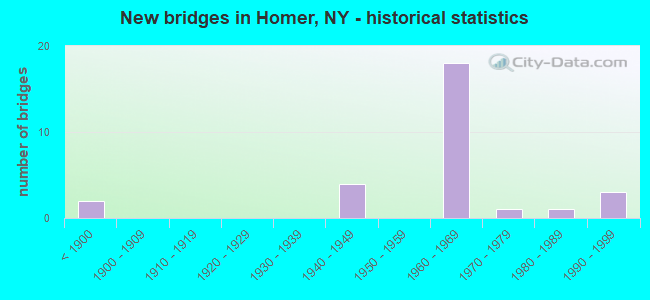
- New bridges - historical statistics
- 2Before 1900
- 41940-1949
- 181960-1969
- 11970-1979
- 11980-1989
- 31990-1999

- Reconstructed bridges - Historical Statistics
- 31980-1989
- 01990-1999
- 12000-2009
- 12010-2019


- Bridge Condition - Deck
- 5.3%Very good
- 5.3%Good
- 52.6%Satisfactory
- 36.8%Fair

- Bridge Condition - Superstructure
- 30.0%Good
- 40.0%Satisfactory
- 20.0%Fair
- 10.0%Poor

- Bridge Condition - Substructure
- 5.0%Very good
- 30.0%Good
- 30.0%Satisfactory
- 35.0%Fair

- Bridge Condition - Channel
- 23.1%Good
- 38.5%Satisfactory
- 38.5%Fair
Find on map >> Show street view
Structure Number: 10084, Location: 2.3 MI N JCT RTS 11 + 222 (Lat: 42.627831, Lng: -76.181156), Route carried "on" structure: Ramp State highway 930, Year Built: 1966, Year Reconstructed: 1980, Status: Open, Structure Length: 5.00m (16.40ft), Average Daily Traffic: 8,010 (year 2018), Truck Traffic: 11%, Average Future Daily Traffic: 8,047 (year 2040), Design Load: HS 20, Features Intersected: RTE 11, RTES 11&41&90
Minimum Vertical Clearance: 30+ m (98+ ft), Kilometerpoint: 0.853, Lanes on structure: 4, Lanes under structure: 3, Base Highway Network: Yes, Owner: State Highway Agency, Approaching Roadway Width: 20.1m (65.9ft), Skew: 2 degrees, Material/Design: Steel, Design/Construction: Stringer/Multi-beam, Number Of Spans In Main Unit: 3, Length of Maximum Span: 27.7m (90.9ft), Curb-To-Curb Width: 17.1m (56.1ft), Out-to-Out Width: 18.7m (61.4ft)
Condition: Deck: Fair, Superstructure: Satisfactory, Substructure: Fair, Operating Rating: 68.9 metric tons, Method Used To Determine Operating Rating: Load Factor (LF), Inventory Rating: 40.8 metric tons, Method Used To Determine Inventory Rating: Load Factor (LF), Structural Evaluation: Somewhat better than minimum adequacy, Deck Geometry: Somewhat better than minimum adequacy, Underclear: Meets minimum limits, Approach Roadway Alignment: Equal to present desirable criteria, Length Of Structure Improvement: 4.99m (16.37ft), Designated Inspection Frequency: Every 24 months, Inspection Date: June 2021, Bridge Improvement Cost: $1,979,000, Roadway Improvement Cost: $1,159,000, Total Project Cost: $3,138,000 ( Estimate for 2021), Deck Structure Type: Concrete Cast-file-Place, Wearing Surface/Protective System: Wearing Surface: Monolithic Concrete
Find on map >> Show street view
Structure Number: 100841, Location: 3.6 MI N JCT RTS 11 + 222 (Lat: 42.643469, Lng: -76.177808), Route carried "on" structure: US 11, Year Built: 1965, Status: Open, Structure Length: 1.04m (3.41ft), Average Daily Traffic: 1,727 (year 2018), Truck Traffic: 10%, Average Future Daily Traffic: 2,136 (year 2040), Design Load: HS 20, Features Intersected: FACTORY BROOK
Minimum Vertical Clearance: 30+ m (98+ ft), Kilometerpoint: 32.534, Lanes on structure: 2, Base Highway Network: Yes, Owner: State Highway Agency, Approaching Roadway Width: 12.2m (40.0ft), Material/Design: Concrete, Design/Construction: Culvert, Number Of Spans In Main Unit: 2, Length of Maximum Span: 4.5m (14.8ft), Curb or Sidewalk Widths: Left: 1.6m (5.2ft), Right: 1.6m (5.2ft), Curb-To-Curb Width: 12.2m (40.0ft), Out-to-Out Width: 16.0m (52.5ft)
Condition: Channel: Satisfactory, Culverts: Good, Operating Rating: 75.8 metric tons, Method Used To Determine Operating Rating: Field evaluation and documented engineering judgment, Inventory Rating: 32.7 metric tons, Method Used To Determine Inventory Rating: Field evaluation and documented engineering judgment, Structural Evaluation: Better than present minimum criteria, Deck Geometry: Better than present minimum criteria, Waterway Adequacy: Meets minimum limits, Approach Roadway Alignment: Equal to present desirable criteria, Length Of Structure Improvement: 1.03m (3.38ft), Designated Inspection Frequency: Every 24 months, Inspection Date: September 2021, Bridge Improvement Cost: $792,000, Roadway Improvement Cost: $464,000, Total Project Cost: $1,256,000 ( Estimate for 2021), Wearing Surface/Protective System: Wearing Surface: Bituminous
Find on map >> Show street view
Structure Number: 100842, Location: 4.0 MI N JCT RTS 11 & 222 (Lat: 42.649131, Lng: -76.176492), Route carried "on" structure: US 11, Year Built: 1998, Status: Open, Structure Length: 2.83m (9.28ft), Average Daily Traffic: 1,727 (year 2018), Truck Traffic: 10%, Average Future Daily Traffic: 2,136 (year 2040), Design Load: HS 25 or greater, Features Intersected: WEST BRANCH TIOUG
Minimum Vertical Clearance: 30+ m (98+ ft), Kilometerpoint: 33.161, Lanes on structure: 2, Base Highway Network: Yes, Owner: State Highway Agency, Approaching Roadway Width: 12.2m (40.0ft), Skew: 3 degrees, Material/Design: Prestressed concrete, Design/Construction: Box Beam or Girders - Multiple, Number Of Spans In Main Unit: 1, Length of Maximum Span: 27.1m (88.9ft), Curb or Sidewalk Widths: Left: 0.0m, Right: 1.5m (4.9ft), Curb-To-Curb Width: 12.2m (40.0ft), Out-to-Out Width: 14.5m (47.6ft)
Condition: Deck: Fair, Superstructure: Good, Substructure: Good, Channel: Good, Inventory Rating: 60.8 metric tons, Method Used To Determine Inventory Rating: Load Factor (LF), Structural Evaluation: Better than present minimum criteria, Deck Geometry: Better than present minimum criteria, Waterway Adequacy: Meets minimum limits, Approach Roadway Alignment: Equal to present desirable criteria, Length Of Structure Improvement: 2.83m (9.28ft), Designated Inspection Frequency: Every 24 months, Inspection Date: March 2020, Bridge Improvement Cost: $1,417,000, Roadway Improvement Cost: $830,000, Total Project Cost: $2,246,000 ( Estimate for 2021), Wearing Surface/Protective System: Wearing Surface: Monolithic Concrete
Find on map >> Show street view
Structure Number: 1008431, Location: JCT OF RTS 11 + I-81 SB (Lat: 42.656003, Lng: -76.172639), Route carried "on" structure: Interstate 81, Year Built: 1966, Status: Open, Structure Length: 7.83m (25.69ft), Average Daily Traffic: 13,527 (year 2008), Truck Traffic: 22%, Design Load: HS 20, Features Intersected: RTE 11
Minimum Vertical Clearance: 30+ m (98+ ft), Kilometerpoint: 33.049, Lanes on structure: 2, Lanes under structure: 2, Base Highway Network: Yes, Owner: State Highway Agency, Approaching Roadway Width: 13.7m (44.9ft), Skew: 5 degrees, Material/Design: Steel, Design/Construction: Stringer/Multi-beam, Number Of Spans In Main Unit: 3, Length of Maximum Span: 24.1m (79.1ft), Curb-To-Curb Width: 9.1m (29.9ft), Out-to-Out Width: 10.7m (35.1ft)
Condition: Deck: Satisfactory, Superstructure: Fair, Substructure: Satisfactory, Operating Rating: 64.4 metric tons, Method Used To Determine Operating Rating: Load Factor (LF), Inventory Rating: 38.1 metric tons, Method Used To Determine Inventory Rating: Load Factor (LF), Structural Evaluation: Somewhat better than minimum adequacy, Deck Geometry: Meets minimum limits, Underclear: Somewhat better than minimum adequacy, Approach Roadway Alignment: Equal to present desirable criteria, Length Of Structure Improvement: 7.98m (26.18ft), Designated Inspection Frequency: Every 24 months, Inspection Date: July 2021, Bridge Improvement Cost: $1,831,000, Roadway Improvement Cost: $1,072,000, Total Project Cost: $2,904,000 ( Estimate for 2021), Deck Structure Type: Concrete Cast-file-Place, Wearing Surface/Protective System: Wearing Surface: Epoxy Overlay
Find on map >> Show street view
Structure Number: 1008432, Location: JCT OF RTS 11 + I-81 NB (Lat: 42.656606, Lng: -76.172306), Route carried "on" structure: Interstate 81, Year Built: 1966, Year Reconstructed: 1980, Status: Open, Structure Length: 7.47m (24.51ft), Average Daily Traffic: 11,219 (year 2019), Truck Traffic: 17%, Average Future Daily Traffic: 12,576 (year 2040), Design Load: HS 20, Features Intersected: RTE 11
Minimum Vertical Clearance: 30+ m (98+ ft), Kilometerpoint: 33.049, Lanes on structure: 2, Lanes under structure: 2, Base Highway Network: Yes, Owner: State Highway Agency, Approaching Roadway Width: 13.7m (44.9ft), Skew: 5 degrees, Material/Design: Steel, Design/Construction: Stringer/Multi-beam, Number Of Spans In Main Unit: 3, Length of Maximum Span: 33.2m (108.9ft), Curb-To-Curb Width: 9.1m (29.9ft), Out-to-Out Width: 10.7m (35.1ft)
Condition: Deck: Satisfactory, Superstructure: Fair, Substructure: Good, Operating Rating: 48.1 metric tons, Method Used To Determine Operating Rating: Load Factor (LF), Inventory Rating: 28.1 metric tons, Method Used To Determine Inventory Rating: Load Factor (LF), Structural Evaluation: Somewhat better than minimum adequacy, Deck Geometry: Meets minimum limits, Underclear: Somewhat better than minimum adequacy, Approach Roadway Alignment: Equal to present desirable criteria, Length Of Structure Improvement: 7.46m (24.48ft), Designated Inspection Frequency: Every 24 months, Inspection Date: July 2021, Bridge Improvement Cost: $1,693,000, Roadway Improvement Cost: $992,000, Total Project Cost: $2,685,000 ( Estimate for 2021), Deck Structure Type: Concrete Cast-file-Place, Wearing Surface/Protective System: Wearing Surface: Epoxy Overlay
Find on map >> Show street view
Structure Number: 102492, Location: 0.1 MI E JCT RTS 41 & 281 (Lat: 42.644225, Lng: -76.187050), Route carried "on" structure: State highway 41, Year Built: 1998, Status: Open, Structure Length: 1.10m (3.61ft), Average Daily Traffic: 1,694 (year 2018), Truck Traffic: 8%, Average Future Daily Traffic: 2,057 (year 2040), Design Load: HS 25 or greater, Features Intersected: FACTORY BROOK
Minimum Vertical Clearance: 30+ m (98+ ft), Kilometerpoint: 45.631, Lanes on structure: 2, Base Highway Network: Yes, Owner: State Highway Agency, Approaching Roadway Width: 8.8m (28.9ft), Material/Design: Concrete, Design/Construction: Frame, Number Of Spans In Main Unit: 1, Length of Maximum Span: 10.3m (33.8ft), Curb or Sidewalk Widths: Left: 0.0m, Right: 1.6m (5.2ft), Curb-To-Curb Width: 9.0m (29.5ft), Out-to-Out Width: 11.3m (37.1ft)
Condition: Superstructure: Good, Substructure: Very good, Channel: Satisfactory, Operating Rating: 46.3 metric tons, Method Used To Determine Operating Rating: Load Factor (LF), Inventory Rating: 28.1 metric tons, Method Used To Determine Inventory Rating: Load Factor (LF), Structural Evaluation: Better than present minimum criteria, Deck Geometry: Somewhat better than minimum adequacy, Waterway Adequacy: Meets minimum limits, Approach Roadway Alignment: Equal to present desirable criteria, Length Of Structure Improvement: 1.09m (3.58ft), Designated Inspection Frequency: Every 24 months, Inspection Date: May 2020, Bridge Improvement Cost: $414,000, Roadway Improvement Cost: $243,000, Total Project Cost: $657,000 ( Estimate for 2021), Wearing Surface/Protective System: Wearing Surface: Bituminous
Find on map >> Show street view
Structure Number: 102493, Location: 0.8 MI NW JCT RTS 41 +281 (Lat: 42.653792, Lng: -76.197869), Route carried "on" structure: State highway 41, Year Built: 1940, Status: Open, Structure Length: 0.79m (2.59ft), Average Daily Traffic: 3,102 (year 2018), Truck Traffic: 11%, Average Future Daily Traffic: 4,336 (year 2040), Design Load: HS 20, Features Intersected: FACTORY CREEK
Minimum Vertical Clearance: 30+ m (98+ ft), Kilometerpoint: 47.063, Lanes on structure: 2, Base Highway Network: Yes, Owner: State Highway Agency, Approaching Roadway Width: 8.8m (28.9ft), Skew: 4 degrees, Material/Design: Concrete, Design/Construction: Slab, Number Of Spans In Main Unit: 1, Length of Maximum Span: 7.6m (24.9ft), Curb-To-Curb Width: 8.4m (27.6ft), Out-to-Out Width: 9.1m (29.9ft)
Condition: Deck: Satisfactory, Superstructure: Satisfactory, Substructure: Satisfactory, Channel: Fair, Operating Rating: 38.1 metric tons, Method Used To Determine Operating Rating: Load Factor (LF), Inventory Rating: 22.7 metric tons, Method Used To Determine Inventory Rating: Load Factor (LF), Structural Evaluation: Equal to present minimum criteria, Deck Geometry: High priority of corrective action, Waterway Adequacy: Meets minimum limits, Approach Roadway Alignment: Equal to present desirable criteria, Length Of Structure Improvement: 0.79m (2.59ft), Designated Inspection Frequency: Every 24 months, Inspection Date: November 2021, Bridge Improvement Cost: $545,000, Roadway Improvement Cost: $319,000, Total Project Cost: $865,000 ( Estimate for 2021), Wearing Surface/Protective System: Wearing Surface: Bituminous
Find on map >> Show street view
Structure Number: 10314, Location: 2.3 MI N JCT RTS I-81 +13 (Lat: 42.630092, Lng: -76.173294), Route carried "on" structure: Other road , Year Built: 1966, Status: Open, Structure Length: 13.23m (43.41ft), Average Daily Traffic: 3,765 (year 2019), Truck Traffic: 7%, Average Future Daily Traffic: 4,658 (year 2040), Design Load: HS 20, Features Intersected: RTE I81, RTE I81, Facility Carried by Structure: ALBANY STREET
Minimum Vertical Clearance: 30+ m (98+ ft), Kilometerpoint: 0.515, Lanes on structure: 2, Lanes under structure: 4, Owner: State Highway Agency, Approaching Roadway Width: 7.6m (24.9ft), Skew: 4 degrees, Material/Design: Steel, Design/Construction: Stringer/Multi-beam, Number Of Spans In Main Unit: 7, Length of Maximum Span: 25.6m (84.0ft), Curb-To-Curb Width: 9.1m (29.9ft), Out-to-Out Width: 10.7m (35.1ft)
Condition: Deck: Satisfactory, Superstructure: Good, Substructure: Satisfactory, Operating Rating: 46.3 metric tons, Method Used To Determine Operating Rating: Load Factor (LF), Inventory Rating: 27.2 metric tons, Method Used To Determine Inventory Rating: Load Factor (LF), Structural Evaluation: Equal to present minimum criteria, Deck Geometry: Meets minimum limits, Underclear: High priority of corrective action, Approach Roadway Alignment: Equal to present desirable criteria, Length Of Structure Improvement: 13.22m (43.37ft), Designated Inspection Frequency: Every 24 months, Inspection Date: September 2021, Bridge Improvement Cost: $2,768,000, Roadway Improvement Cost: $1,621,000, Total Project Cost: $4,389,000 ( Estimate for 2021), Deck Structure Type: Concrete Cast-file-Place, Wearing Surface/Protective System: Wearing Surface: Monolithic Concrete
Find on map >> Show street view
Structure Number: 1031411, Location: 4.3 MI N JCT I81 & SH 13 (Lat: 42.658675, Lng: -76.173972), Route carried "on" structure: Interstate 81, Year Built: 1966, Status: Open, Structure Length: 6.77m (22.21ft), Average Daily Traffic: 13,527 (year 2008), Truck Traffic: 22%, Design Load: HS 20, Features Intersected: NY SUSQUEHANNA& W
Minimum Vertical Clearance: 30+ m (98+ ft), Kilometerpoint: 33.371, Lanes on structure: 2, Base Highway Network: Yes, Owner: State Highway Agency, Approaching Roadway Width: 12.2m (40.0ft), Skew: 5 degrees, Material/Design: Steel, Design/Construction: Stringer/Multi-beam, Number Of Spans In Main Unit: 3, Length of Maximum Span: 21.3m (69.9ft), Curb-To-Curb Width: 9.1m (29.9ft), Out-to-Out Width: 10.8m (35.4ft)
Condition: Deck: Satisfactory, Superstructure: Satisfactory, Substructure: Good, Operating Rating: 69.9 metric tons, Method Used To Determine Operating Rating: Load Factor (LF), Inventory Rating: 41.7 metric tons, Method Used To Determine Inventory Rating: Load Factor (LF), Structural Evaluation: Equal to present minimum criteria, Deck Geometry: Meets minimum limits, Underclear: Equal to present minimum criteria, Approach Roadway Alignment: Equal to present minimum criteria, Length Of Structure Improvement: 6.76m (22.18ft), Designated Inspection Frequency: Every 24 months, Inspection Date: November 2021, Bridge Improvement Cost: $1,582,000, Roadway Improvement Cost: $926,000, Total Project Cost: $2,508,000 ( Estimate for 2021), Deck Structure Type: Concrete Cast-file-Place, Wearing Surface/Protective System: Wearing Surface: Bituminous
Find on map >> Show street view
Structure Number: 1031412, Location: 4.3 MI N JCT I81 & SH 13 (Lat: 42.659322, Lng: -76.173633), Route carried "on" structure: Interstate 81, Year Built: 1966, Status: Open, Structure Length: 7.19m (23.59ft), Average Daily Traffic: 11,219 (year 2019), Truck Traffic: 17%, Average Future Daily Traffic: 12,576 (year 2040), Design Load: HS 20, Features Intersected: NY SUSQUEHANNA& W
Minimum Vertical Clearance: 30+ m (98+ ft), Kilometerpoint: 33.371, Lanes on structure: 2, Base Highway Network: Yes, Owner: State Highway Agency, Approaching Roadway Width: 12.2m (40.0ft), Skew: 5 degrees, Material/Design: Steel, Design/Construction: Stringer/Multi-beam, Number Of Spans In Main Unit: 3, Length of Maximum Span: 22.8m (74.8ft), Curb-To-Curb Width: 9.1m (29.9ft), Out-to-Out Width: 10.8m (35.4ft)
Condition: Deck: Satisfactory, Superstructure: Good, Substructure: Good, Operating Rating: 73.5 metric tons, Method Used To Determine Operating Rating: Load Factor (LF), Inventory Rating: 43.5 metric tons, Method Used To Determine Inventory Rating: Load Factor (LF), Structural Evaluation: Better than present minimum criteria, Deck Geometry: Meets minimum limits, Underclear: Somewhat better than minimum adequacy, Approach Roadway Alignment: Equal to present minimum criteria, Length Of Structure Improvement: 7.19m (23.59ft), Designated Inspection Frequency: Every 24 months, Inspection Date: November 2021, Bridge Improvement Cost: $1,682,000, Roadway Improvement Cost: $985,000, Total Project Cost: $2,667,000 ( Estimate for 2021), Deck Structure Type: Concrete Cast-file-Place, Wearing Surface/Protective System: Wearing Surface: Bituminous
Find on map >> Show street view
Structure Number: 1031421, Location: 7 MI N JCT I81 & SH 13 (Lat: 42.695689, Lng: -76.157031), Route carried "on" structure: Interstate 81, Year Built: 1966, Status: Open, Structure Length: 4.18m (13.71ft), Average Daily Traffic: 13,527 (year 2008), Truck Traffic: 22%, Design Load: HS 20+Mod, Features Intersected: COUNTY ROAD 109
Minimum Vertical Clearance: 30+ m (98+ ft), Kilometerpoint: 37.683, Lanes on structure: 2, Lanes under structure: 2, Base Highway Network: Yes, Owner: State Highway Agency, Approaching Roadway Width: 9.1m (29.9ft), Skew: 1 degrees, Material/Design: Steel, Design/Construction: Stringer/Multi-beam, Number Of Spans In Main Unit: 3, Length of Maximum Span: 14.9m (48.9ft), Curb-To-Curb Width: 9.2m (30.2ft), Out-to-Out Width: 10.9m (35.8ft)
Condition: Deck: Fair, Superstructure: Satisfactory, Substructure: Satisfactory, Operating Rating: 73.5 metric tons, Method Used To Determine Operating Rating: Load Factor (LF), Inventory Rating: 43.5 metric tons, Method Used To Determine Inventory Rating: Load Factor (LF), Structural Evaluation: Equal to present minimum criteria, Deck Geometry: High priority of replacement, Underclear: Meets minimum limits, Approach Roadway Alignment: Equal to present desirable criteria, Length Of Structure Improvement: 4.17m (13.68ft), Designated Inspection Frequency: Every 24 months, Inspection Date: April 2021, Bridge Improvement Cost: $945,000, Roadway Improvement Cost: $554,000, Total Project Cost: $1,499,000 ( Estimate for 2021), Deck Structure Type: Concrete Cast-file-Place, Wearing Surface/Protective System: Wearing Surface: Monolithic Concrete
Find on map >> Show street view
Structure Number: 1031422, Location: 7 MI N JCT I81 & SH 13 (Lat: 42.695619, Lng: -76.156517), Route carried "on" structure: Interstate 81, Year Built: 1966, Status: Open, Structure Length: 4.18m (13.71ft), Average Daily Traffic: 11,219 (year 2019), Truck Traffic: 17%, Average Future Daily Traffic: 12,576 (year 2040), Design Load: HS 20+Mod, Features Intersected: COUNTY ROAD 109
Minimum Vertical Clearance: 30+ m (98+ ft), Kilometerpoint: 37.683, Lanes on structure: 2, Lanes under structure: 2, Base Highway Network: Yes, Owner: State Highway Agency, Approaching Roadway Width: 9.1m (29.9ft), Skew: 1 degrees, Material/Design: Steel, Design/Construction: Stringer/Multi-beam, Number Of Spans In Main Unit: 3, Length of Maximum Span: 14.9m (48.9ft), Curb-To-Curb Width: 9.2m (30.2ft), Out-to-Out Width: 10.9m (35.8ft)
Condition: Deck: Satisfactory, Superstructure: Fair, Substructure: Satisfactory, Operating Rating: 72.6 metric tons, Method Used To Determine Operating Rating: Load Factor (LF), Inventory Rating: 43.5 metric tons, Method Used To Determine Inventory Rating: Load Factor (LF), Structural Evaluation: Somewhat better than minimum adequacy, Deck Geometry: High priority of replacement, Underclear: Meets minimum limits, Approach Roadway Alignment: Equal to present desirable criteria, Length Of Structure Improvement: 4.17m (13.68ft), Designated Inspection Frequency: Every 24 months, Inspection Date: May 2021, Bridge Improvement Cost: $945,000, Roadway Improvement Cost: $554,000, Total Project Cost: $1,499,000 ( Estimate for 2021), Deck Structure Type: Concrete Cast-file-Place, Wearing Surface/Protective System: Wearing Surface: Epoxy Overlay
Find on map >> Show street view
Structure Number: 104442, Location: 0.7 MI N JCT RTS 90 + 281 (Lat: 42.643369, Lng: -76.188439), Route carried "on" structure: State highway 281, Year Built: 1946, Status: Open, Structure Length: 1.46m (4.79ft), Average Daily Traffic: 7,789 (year 2020), Truck Traffic: 9%, Average Future Daily Traffic: 9,462 (year 2040), Design Load: H 20, Features Intersected: FACTORY BROOK
Minimum Vertical Clearance: 30+ m (98+ ft), Kilometerpoint: 7.852, Lanes on structure: 2, Base Highway Network: Yes, Owner: State Highway Agency, Approaching Roadway Width: 9.8m (32.2ft), Skew: 3 degrees, Material/Design: Steel, Design/Construction: Stringer/Multi-beam, Number Of Spans In Main Unit: 1, Length of Maximum Span: 14.3m (46.9ft), Curb or Sidewalk Widths: Left: 0.0m, Right: 1.9m (6.2ft), Curb-To-Curb Width: 10.4m (34.1ft), Out-to-Out Width: 12.4m (40.7ft)
Condition: Deck: Fair, Superstructure: Satisfactory, Substructure: Fair, Channel: Good, Operating Rating: 39.9 metric tons, Method Used To Determine Operating Rating: Load Factor (LF), Inventory Rating: 23.6 metric tons, Method Used To Determine Inventory Rating: Load Factor (LF), Structural Evaluation: Somewhat better than minimum adequacy, Deck Geometry: Meets minimum limits, Waterway Adequacy: Somewhat better than minimum adequacy, Approach Roadway Alignment: Equal to present desirable criteria, Length Of Structure Improvement: 1.46m (4.79ft), Designated Inspection Frequency: Every 24 months, Inspection Date: November 2021, Bridge Improvement Cost: $644,000, Roadway Improvement Cost: $377,000, Total Project Cost: $1,021,000 ( Estimate for 2021), Deck Structure Type: Concrete Cast-file-Place, Wearing Surface/Protective System: Wearing Surface: Bituminous
Find on map >> Show street view
Structure Number: 104443, Location: 3.0 MI N JCT RTS 41 + 281 (Lat: 42.685675, Lng: -76.169442), Route carried "on" structure: State highway 281, Year Built: 1946, Year Reconstructed: 2012, Status: Open, Structure Length: 1.58m (5.18ft), Average Daily Traffic: 4,065 (year 2020), Truck Traffic: 7%, Average Future Daily Traffic: 5,683 (year 2040), Design Load: H 20, Features Intersected: COLD BROOK
Minimum Vertical Clearance: 30+ m (98+ ft), Kilometerpoint: 12.824, Lanes on structure: 2, Base Highway Network: Yes, Owner: State Highway Agency, Approaching Roadway Width: 9.8m (32.2ft), Skew: 2 degrees, Material/Design: Steel, Design/Construction: Stringer/Multi-beam, Number Of Spans In Main Unit: 1, Length of Maximum Span: 15.5m (50.9ft), Curb-To-Curb Width: 10.4m (34.1ft), Out-to-Out Width: 10.9m (35.8ft)
Condition: Deck: Satisfactory, Superstructure: Good, Substructure: Satisfactory, Channel: Good, Operating Rating: 50.8 metric tons, Method Used To Determine Operating Rating: Load Factor (LF), Inventory Rating: 29.9 metric tons, Method Used To Determine Inventory Rating: Load Factor (LF), Structural Evaluation: Equal to present minimum criteria, Deck Geometry: Somewhat better than minimum adequacy, Waterway Adequacy: Somewhat better than minimum adequacy, Approach Roadway Alignment: Equal to present desirable criteria, Length Of Structure Improvement: 1.58m (5.18ft), Designated Inspection Frequency: Every 24 months, Inspection Date: August 2021, Bridge Improvement Cost: $510,000, Roadway Improvement Cost: $299,000, Total Project Cost: $809,000 ( Estimate for 2021), Deck Structure Type: Concrete Cast-file-Place, Wearing Surface/Protective System: Wearing Surface: Integral Concrete
Find on map >> Show street view
Structure Number: 106481, Location: HOMER INT + TIOUGHNIOGA R (Lat: 42.627442, Lng: -76.179953), Route carried "on" structure: Ramp State highway 930, Year Built: 1966, Status: Open, Structure Length: 5.64m (18.50ft), Average Daily Traffic: 8,010 (year 2018), Truck Traffic: 11%, Average Future Daily Traffic: 8,282 (year 2040), Design Load: HS 20, Features Intersected: TIOUGHNIOGA RIVER
Minimum Vertical Clearance: 30+ m (98+ ft), Kilometerpoint: 0.965, Lanes on structure: 4, Base Highway Network: Yes, Owner: State Highway Agency, Approaching Roadway Width: 21.0m (68.9ft), Skew: 22 degrees, Material/Design: Steel, Design/Construction: Stringer/Multi-beam, Number Of Spans In Main Unit: 3, Length of Maximum Span: 18.5m (60.7ft), Curb-To-Curb Width: 17.7m (58.1ft), Out-to-Out Width: 19.3m (63.3ft)
Condition: Deck: Fair, Superstructure: Satisfactory, Substructure: Fair, Channel: Satisfactory, Operating Rating: 52.6 metric tons, Method Used To Determine Operating Rating: Load Factor (LF), Inventory Rating: 30.8 metric tons, Method Used To Determine Inventory Rating: Load Factor (LF), Structural Evaluation: Somewhat better than minimum adequacy, Deck Geometry: Equal to present minimum criteria, Waterway Adequacy: Equal to present minimum criteria, Approach Roadway Alignment: Equal to present desirable criteria, Length Of Structure Improvement: 5.63m (18.47ft), Designated Inspection Frequency: Every 24 months, Inspection Date: May 2021, Bridge Improvement Cost: $2,243,000, Roadway Improvement Cost: $1,314,000, Total Project Cost: $3,557,000 ( Estimate for 2021), Deck Structure Type: Concrete Cast-file-Place, Wearing Surface/Protective System: Wearing Surface: Monolithic Concrete
Find on map >> Show street view
Structure Number: 106482, Location: HOMER INTERCHANGE & NYS&W (Lat: 42.627978, Lng: -76.184022), Route carried "on" structure: Ramp State highway 930, Year Built: 1966, Status: Open, Structure Length: 4.11m (13.48ft), Average Daily Traffic: 8,010 (year 2018), Truck Traffic: 11%, Average Future Daily Traffic: 8,047 (year 2040), Design Load: HS 20, Features Intersected: NY SUSQUEHANNA & WESTERN
Minimum Vertical Clearance: 30+ m (98+ ft), Kilometerpoint: 0.644, Lanes on structure: 2, Base Highway Network: Yes, Owner: State Highway Agency, Approaching Roadway Width: 9.1m (29.9ft), Material/Design: Steel, Design/Construction: Stringer/Multi-beam, Number Of Spans In Main Unit: 3, Length of Maximum Span: 13.1m (43.0ft), Curb-To-Curb Width: 9.1m (29.9ft), Out-to-Out Width: 10.8m (35.4ft)
Condition: Deck: Satisfactory, Superstructure: Satisfactory, Substructure: Fair, Operating Rating: 68.9 metric tons, Method Used To Determine Operating Rating: Load Factor (LF), Inventory Rating: 40.8 metric tons, Method Used To Determine Inventory Rating: Load Factor (LF), Structural Evaluation: Somewhat better than minimum adequacy, Deck Geometry: Meets minimum limits, Underclear: Meets minimum limits, Approach Roadway Alignment: Equal to present desirable criteria, Length Of Structure Improvement: 4.11m (13.48ft), Designated Inspection Frequency: Every 24 months, Inspection Date: December 2021, Bridge Improvement Cost: $944,000, Roadway Improvement Cost: $553,000, Total Project Cost: $1,497,000 ( Estimate for 2021), Deck Structure Type: Concrete Cast-file-Place, Wearing Surface/Protective System: Wearing Surface: Monolithic Concrete
Find on map >> Show street view
Structure Number: 109373, Location: 1.4 MI NW JCT RTS 41 +281 (Lat: 42.661158, Lng: -76.204992), Route carried "on" structure: State highway 41, Year Built: 1969, Status: Open, Structure Length: 0.82m (2.69ft), Average Daily Traffic: 3,102 (year 2018), Truck Traffic: 11%, Average Future Daily Traffic: 3,838 (year 2040), Design Load: HS 20, Features Intersected: FACTORY BROOK
Minimum Vertical Clearance: 30+ m (98+ ft), Kilometerpoint: 48.077, Lanes on structure: 2, Base Highway Network: Yes, Owner: State Highway Agency, Approaching Roadway Width: 11.0m (36.1ft), Skew: 2 degrees, Material/Design: Steel, Design/Construction: Culvert, Number Of Spans In Main Unit: 2, Length of Maximum Span: 3.7m (12.1ft)
Condition: Channel: Fair, Culverts: Good, Operating Rating: 75.1 metric tons, Method Used To Determine Operating Rating: Field evaluation and documented engineering judgment, Inventory Rating: 32.7 metric tons, Method Used To Determine Inventory Rating: Field evaluation and documented engineering judgment, Structural Evaluation: Better than present minimum criteria, Waterway Adequacy: Meets minimum limits, Approach Roadway Alignment: Equal to present desirable criteria, Length Of Structure Improvement: 0.82m (2.69ft), Designated Inspection Frequency: Every 24 months, Inspection Date: November 2021, Bridge Improvement Cost: $209,000, Roadway Improvement Cost: $123,000, Total Project Cost: $332,000 ( Estimate for 2021)
Find on map >> Show street view
Structure Number: 220739, Location: 3.0 MILES N OF HOMER (Lat: 42.692456, Lng: -76.177658), Route carried "on" structure: Other road , Year Built: 1987, Status: Open, Structure Length: 1.01m (3.31ft), Average Daily Traffic: 13 (year 2018), Average Future Daily Traffic: 18 (year 2038), Features Intersected: COLD BROOK, Facility Carried by Structure: AYERS ROAD
Minimum Vertical Clearance: 30+ m (98+ ft), Kilometerpoint: 0.032, Lanes on structure: 1, Owner: Town or Township Highway Agency, Approaching Roadway Width: 4.9m (16.1ft), Skew: 1 degrees, Material/Design: Wood or Timber, Design/Construction: Slab, Number Of Spans In Main Unit: 1, Length of Maximum Span: 9.4m (30.8ft), Curb-To-Curb Width: 4.8m (15.7ft), Out-to-Out Width: 5.5m (18.0ft)
Condition: Deck: Satisfactory, Superstructure: Satisfactory, Substructure: Good, Channel: Fair, Operating Rating: 75.3 metric tons, Method Used To Determine Operating Rating: Allowable Stress (AS), Inventory Rating: 50.8 metric tons, Method Used To Determine Inventory Rating: Allowable Stress (AS), Structural Evaluation: Equal to present minimum criteria, Deck Geometry: Equal to present desirable criteria, Waterway Adequacy: Meets minimum limits, Approach Roadway Alignment: Equal to present desirable criteria, Length Of Structure Improvement: 1.00m (3.28ft), Designated Inspection Frequency: Every 24 months, Inspection Date: March 2021, Bridge Improvement Cost: $216,000, Roadway Improvement Cost: $127,000, Total Project Cost: $343,000 ( Estimate for 2021), Wearing Surface/Protective System: Wearing Surface: Bituminous, Membrane: Other
Find on map >> Show street view
Structure Number: 220769, Location: IN VILLAGE OF HOMER (Lat: 42.636128, Lng: -76.176625), Route carried "on" structure: City street , Year Built: 1878, Year Reconstructed: 2019, Status: Posted for load, Structure Length: 2.19m (7.19ft), Truck Traffic: 4%, Features Intersected: WB TIOUGHNIOGA RV, Facility Carried by Structure: PINE STREET
Minimum Vertical Clearance: 30+ m (98+ ft), Kilometerpoint: 0.145, Lanes on structure: 1, Owner: Town or Township Highway Agency, Approaching Roadway Width: 3.7m (12.1ft), Material/Design: Aluminum, Iron, Design/Construction: Truss - Thru, Number Of Spans In Main Unit: 1, Length of Maximum Span: 21.6m (70.9ft), Curb-To-Curb Width: 3.3m (10.8ft), Out-to-Out Width: 4.0m (13.1ft)
Condition: Deck: Very good, Superstructure: Poor, Substructure: Fair, Channel: Fair, Operating Rating: 17.2 metric tons, Method Used To Determine Operating Rating: Allowable Stress (AS), Inventory Rating: 11.8 metric tons, Method Used To Determine Inventory Rating: Allowable Stress (AS), Structural Evaluation: Meets minimum limits, Deck Geometry: High priority of replacement, Waterway Adequacy: Equal to present desirable criteria, Approach Roadway Alignment: Better than present minimum criteria, Bridge Posting: Required (Relationship of Operating Rating to Maximum Legal Load: > 39.9% below), Length Of Structure Improvement: 2.19m (7.19ft), Designated Inspection Frequency: Every 12 months, Critical Feature Inspection Frequency: Every 12 months, Inspection Date: April 2021, Critical Feature Inspection Date: April 2021, Bridge Improvement Cost: $646,000, Roadway Improvement Cost: $378,000, Total Project Cost: $1,024,000 ( Estimate for 2021), Deck Structure Type: Wood or Timber, Wearing Surface/Protective System: Wearing Surface: Wood or Timber
Find on map >> Show street view
Structure Number: 22077, Location: VILLAGE OF HOMER (Lat: 42.637047, Lng: -76.176614), Route carried "on" structure: Other road , Year Built: 1878, Year Reconstructed: 1988, Status: Closed, Structure Length: 1.80m (5.91ft), Average Daily Traffic: 307 (year 2017), Truck Traffic: 4%, Average Future Daily Traffic: 430 (year 2037), Features Intersected: WB TIOUGHNIOGA RV, Facility Carried by Structure: WALL STREET
Minimum Vertical Clearance: 30+ m (98+ ft), Kilometerpoint: 0.161, Lanes on structure: 1, Owner: Town or Township Highway Agency, Approaching Roadway Width: 3.7m (12.1ft), Material/Design: Aluminum, Iron, Design/Construction: Truss - Thru, Number Of Spans In Main Unit: 1, Length of Maximum Span: 17.6m (57.7ft), Curb-To-Curb Width: 3.3m (10.8ft), Out-to-Out Width: 4.0m (13.1ft)
Condition: Deck: Fair, Superstructure: Poor, Substructure: Fair, Channel: Satisfactory, Waterway Adequacy: Better than present minimum criteria, Approach Roadway Alignment: Equal to present desirable criteria, Bridge Posting: Required (Relationship of Operating Rating to Maximum Legal Load: > 39.9% below), Length Of Structure Improvement: 1.79m (5.87ft), Designated Inspection Frequency: Every 12 months, Critical Feature Inspection Frequency: Every 12 months, Inspection Date: April 2021, Critical Feature Inspection Date: April 2021, Bridge Improvement Cost: $565,000, Roadway Improvement Cost: $331,000, Total Project Cost: $895,000 ( Estimate for 2021), Deck Structure Type: Wood or Timber, Wearing Surface/Protective System: Wearing Surface: Wood or Timber
Find on map >> Show street view
Structure Number: 220772, Location: .3 MI SW JCT US11 & SH90 (Lat: 42.632672, Lng: -76.176794), Route carried "on" structure: Other road , Year Built: 1941, Status: Open, Structure Length: 2.16m (7.09ft), Average Daily Traffic: 3,765 (year 2019), Truck Traffic: 7%, Average Future Daily Traffic: 4,658 (year 2040), Features Intersected: WB TIOUGHNIOGA RV, Facility Carried by Structure: ALBANY STREET
Minimum Vertical Clearance: 30+ m (98+ ft), Kilometerpoint: 0.161, Lanes on structure: 2, Owner: Town or Township Highway Agency, Approaching Roadway Width: 8.2m (26.9ft), Material/Design: Concrete continuous, Design/Construction: Frame, Number Of Spans In Main Unit: 2, Length of Maximum Span: 9.7m (31.8ft), Curb or Sidewalk Widths: Left: 1.5m (4.9ft), Right: 0.0m, Curb-To-Curb Width: 8.2m (26.9ft), Out-to-Out Width: 10.8m (35.4ft)
Condition: Deck: Fair, Superstructure: Fair, Substructure: Fair, Channel: Satisfactory, Operating Rating: 64.6 metric tons, Method Used To Determine Operating Rating: Field evaluation and documented engineering judgment, Inventory Rating: 25.0 metric tons, Method Used To Determine Inventory Rating: Field evaluation and documented engineering judgment, Structural Evaluation: Somewhat better than minimum adequacy, Deck Geometry: High priority of corrective action, Waterway Adequacy: Somewhat better than minimum adequacy, Approach Roadway Alignment: Equal to present minimum criteria, Length Of Structure Improvement: 2.16m (7.09ft), Designated Inspection Frequency: Every 24 months, Inspection Date: October 2021, Bridge Improvement Cost: $567,000, Roadway Improvement Cost: $332,000, Total Project Cost: $899,000 ( Estimate for 2021), Wearing Surface/Protective System: Wearing Surface: Bituminous
Find on map >> Show street view
Structure Number: 331223, Location: 4.8 MI N OF HOMER (Lat: 42.701697, Lng: -76.185564), Route carried "on" structure: County highway , Year Built: 1992, Status: Open, Structure Length: 1.86m (6.10ft), Average Daily Traffic: 678 (year 2017), Truck Traffic: 7%, Average Future Daily Traffic: 949 (year 2037), Design Load: HS 20, Features Intersected: COLD BROOK, Facility Carried by Structure: COLD BROOK ROAD
Minimum Vertical Clearance: 30+ m (98+ ft), Kilometerpoint: 2.172, Lanes on structure: 2, Owner: County Highway Agency, Approaching Roadway Width: 9.1m (29.9ft), Skew: 4 degrees, Material/Design: Prestressed concrete, Design/Construction: Box Beam or Girders - Multiple, Number Of Spans In Main Unit: 1, Length of Maximum Span: 17.6m (57.7ft), Curb-To-Curb Width: 8.5m (27.9ft), Out-to-Out Width: 9.3m (30.5ft)
Condition: Deck: Good, Superstructure: Good, Substructure: Good, Channel: Fair, Operating Rating: 71.7 metric tons, Method Used To Determine Operating Rating: Load Factor (LF), Inventory Rating: 34.5 metric tons, Method Used To Determine Inventory Rating: Load Factor (LF), Structural Evaluation: Better than present minimum criteria, Deck Geometry: Somewhat better than minimum adequacy, Waterway Adequacy: Meets minimum limits, Approach Roadway Alignment: Equal to present desirable criteria, Length Of Structure Improvement: 1.85m (6.07ft), Designated Inspection Frequency: Every 24 months, Inspection Date: March 2021, Bridge Improvement Cost: $566,000, Roadway Improvement Cost: $331,000, Total Project Cost: $897,000 ( Estimate for 2021), Wearing Surface/Protective System: Wearing Surface: Bituminous, Membrane: Other
Find on map >> Show street view
Structure Number: 331225, Location: 3.4 MI NW OF HOMER (Lat: 42.696158, Lng: -76.161972), Route carried "on" structure: County highway , Year Built: 1973, Status: Open, Structure Length: 1.07m (3.51ft), Average Daily Traffic: 736 (year 2017), Truck Traffic: 8%, Average Future Daily Traffic: 1,030 (year 2037), Features Intersected: LITTLE YORK CREEK, Facility Carried by Structure: LITTLE YORK ROAD
Minimum Vertical Clearance: 30+ m (98+ ft), Kilometerpoint: 0.177, Lanes on structure: 2, Owner: County Highway Agency, Approaching Roadway Width: 6.1m (20.0ft), Material/Design: Steel, Design/Construction: Culvert, Number Of Spans In Main Unit: 4, Length of Maximum Span: 2.1m (6.9ft), Curb-To-Curb Width: 7.9m (25.9ft), Out-to-Out Width: 12.2m (40.0ft)
Condition: Culverts: Good, Operating Rating: 74.0 metric tons, Method Used To Determine Operating Rating: Field evaluation and documented engineering judgment, Inventory Rating: 32.7 metric tons, Method Used To Determine Inventory Rating: Field evaluation and documented engineering judgment, Structural Evaluation: Better than present minimum criteria, Deck Geometry: Somewhat better than minimum adequacy, Waterway Adequacy: Equal to present desirable criteria, Approach Roadway Alignment: Better than present minimum criteria, Length Of Structure Improvement: 1.06m (3.48ft), Designated Inspection Frequency: Every 24 months, Inspection Date: October 2021, Bridge Improvement Cost: $301,000, Roadway Improvement Cost: $176,000, Total Project Cost: $478,000 ( Estimate for 2021)
Find on map >> Show street view
Structure Number: 10084, Location: 2.3 MI N JCT RTS 11 + 222 (Lat: 42.627831, Lng: -76.181156), Route carried "under" structure: US 11, Year Built: 1966, Structure Length: 0. m, Average Daily Traffic: 6,255 (year 1999), Features Intersected: RTE 11, RTES 11&41&90, Facility Carried by Structure: RTE 930
Minimum Vertical Clearance: 4.62m (15.16ft), Kilometerpoint: 1.722, Lanes on structure: 4, Lanes under structure: 2, Material/Design: Steel, Design/Construction: Stringer/Multi-beam, Length of Maximum Span: 27.7m (90.9ft)
Find on map >> Show street view
Structure Number: 1008431, Location: JCT OF RTS 11 + I-81 SB (Lat: 42.656003, Lng: -76.172639), Route carried "under" structure: US 11, Year Built: 1966, Structure Length: 0. m, Average Daily Traffic: 2,172 (year 1999), Features Intersected: RTE 11, Facility Carried by Structure: RTE I81
Minimum Vertical Clearance: 4.57m (14.99ft), Kilometerpoint: 5.036, Lanes on structure: 2, Lanes under structure: 2, Material/Design: Steel, Design/Construction: Stringer/Multi-beam, Length of Maximum Span: 24.1m (79.1ft)
Find on map >> Show street view
Structure Number: 1008432, Location: JCT OF RTS 11 + I-81 NB (Lat: 42.656606, Lng: -76.172306), Route carried "under" structure: US 11, Year Built: 1966, Structure Length: 0. m, Average Daily Traffic: 2,172 (year 1999), Features Intersected: RTE 11, Facility Carried by Structure: RTE I81
Minimum Vertical Clearance: 4.59m (15.06ft), Kilometerpoint: 5.036, Lanes on structure: 2, Lanes under structure: 2, Material/Design: Steel, Design/Construction: Stringer/Multi-beam, Length of Maximum Span: 33.2m (108.9ft)
Find on map >> Show street view
Structure Number: 10314, Location: 2.3 MI N JCT RTS I-81 +13 (Lat: 42.630092, Lng: -76.173294), Route carried "under" structure: Interstate 81, Year Built: 1966, Structure Length: 0. m, Average Daily Traffic: 22,061 (year 1999), Features Intersected: RTE I81, RTE I81, Facility Carried by Structure: ALBANY STREET
Minimum Vertical Clearance: 5.00m (16.40ft), Kilometerpoint: 2.027, Lanes on structure: 2, Lanes under structure: 2, Material/Design: Steel, Design/Construction: Stringer/Multi-beam, Length of Maximum Span: 25.6m (84.0ft)
Find on map >> Show street view
Structure Number: 1031421, Location: 7 MI N JCT I81 & SH 13 (Lat: 42.695689, Lng: -76.157031), Route carried "under" structure: County highway , Year Built: 1966, Structure Length: 0. m, Average Daily Traffic: 368 (year 2017), Truck Traffic: 8%, Features Intersected: COUNTY ROAD 109, Facility Carried by Structure: RTE I81
Minimum Vertical Clearance: 4.37m (14.34ft), Kilometerpoint: 0.177, Lanes on structure: 2, Lanes under structure: 2, Material/Design: Steel, Design/Construction: Stringer/Multi-beam, Length of Maximum Span: 14.9m (48.9ft)
Find on map >> Show street view
Structure Number: 1031422, Location: 7 MI N JCT I81 & SH 13 (Lat: 42.695619, Lng: -76.156517), Route carried "under" structure: County highway , Year Built: 1966, Structure Length: 0. m, Average Daily Traffic: 368 (year 2017), Truck Traffic: 8%, Features Intersected: COUNTY ROAD 109, Facility Carried by Structure: RTE I81
Minimum Vertical Clearance: 4.26m (13.98ft), Kilometerpoint: 0.611, Lanes on structure: 2, Lanes under structure: 2, Material/Design: Steel, Design/Construction: Stringer/Multi-beam, Length of Maximum Span: 14.9m (48.9ft)