Bridge Statistics for Holts Summit, Missouri (MO)
Condition, Traffic, Stress, Structural Evaluation, Project Costs
- National Bridge Inventory (NBI) Statistics
- 15Number of bridges
- 112ft / 33.5mTotal length
- $417,000Total costs
- 71,267Total average daily traffic
- 9,259Total average daily truck traffic
- National Bridge Inventory (NBI) Registered Bridges for Holts Summit
- No street view available for this location
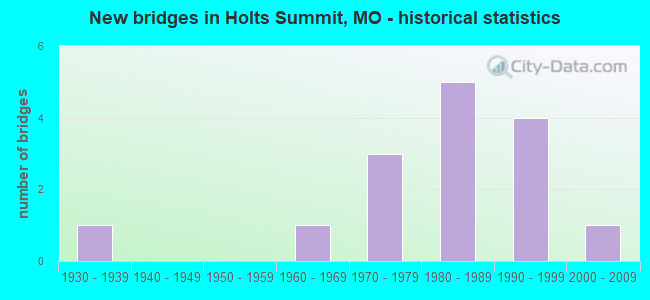
- New bridges - historical statistics
- 11930-1939
- 11960-1969
- 31970-1979
- 51980-1989
- 41990-1999
- 12000-2009
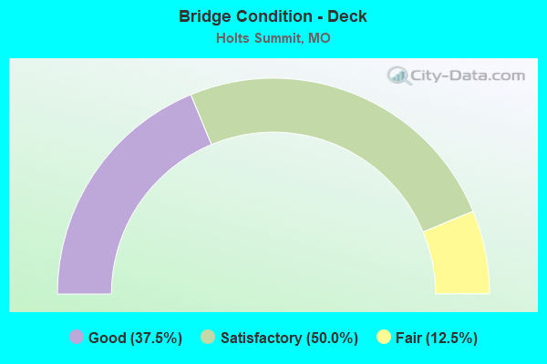
- Bridge Condition - Deck
- 37.5%Good
- 50.0%Satisfactory
- 12.5%Fair
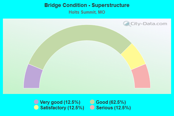
- Bridge Condition - Superstructure
- 12.5%Very good
- 62.5%Good
- 12.5%Satisfactory
- 12.5%Serious
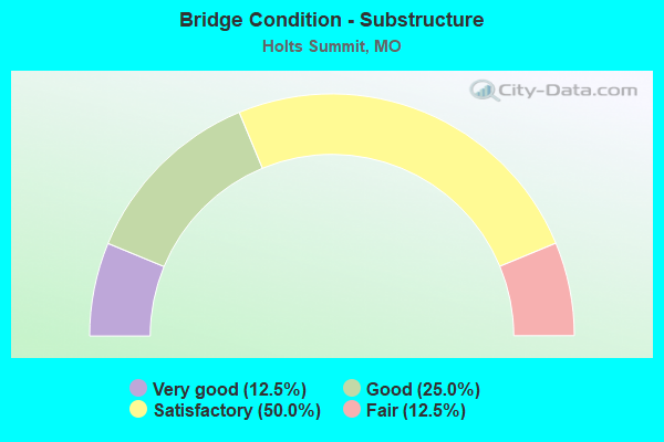
- Bridge Condition - Substructure
- 12.5%Very good
- 25.0%Good
- 50.0%Satisfactory
- 12.5%Fair
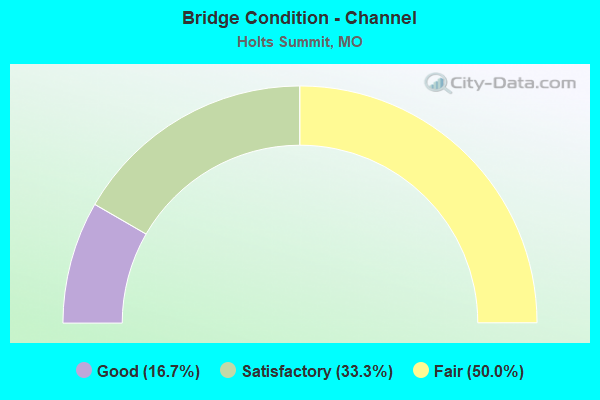
- Bridge Condition - Channel
- 16.7%Good
- 33.3%Satisfactory
- 50.0%Fair
Find on map >> Show street view
Structure Number: 18793, Location: S 15 T 45 N R 11 W (Lat: 38.679661, Lng: -92.156350), Route carried "on" structure: County highway 200, Year Built: 1935, Status: Posted for load, Structure Length: 1.89m (6.20ft), Average Daily Traffic: 10 (year 2021), Truck Traffic: 5%, Average Future Daily Traffic: 15 (year 2041), Features Intersected: CLIFTON CR, Facility Carried by Structure: COUNTY RD 382
Minimum Vertical Clearance: 30+ m (98+ ft), Kilometerpoint: 0.322, Lanes on structure: 1, Owner: County Highway Agency, Approaching Roadway Width: 3.7m (12.1ft), Material/Design: Steel, Design/Construction: Truss - Thru, Number Of Spans In Main Unit: 1, Length of Maximum Span: 18.6m (61.0ft), Curb-To-Curb Width: 3.6m (11.8ft), Out-to-Out Width: 3.6m (11.8ft)
Condition: Deck: Fair, Superstructure: Serious, Substructure: Good, Channel: Satisfactory, Operating Rating: 5.4 metric tons, Method Used To Determine Operating Rating: Allowable Stress (AS), Inventory Rating: 3.6 metric tons, Method Used To Determine Inventory Rating: Allowable Stress (AS), Structural Evaluation: High priority of replacement, Deck Geometry: High priority of corrective action, Waterway Adequacy: Better than present minimum criteria, Approach Roadway Alignment: Equal to present minimum criteria, Bridge Posting: Required (Relationship of Operating Rating to Maximum Legal Load: > 39.9% below), Length Of Structure Improvement: 0.26m (0.85ft), Designated Inspection Frequency: Every 24 months, Critical Feature Inspection Frequency: Every 24 months, Inspection Date: October 2020, Critical Feature Inspection Date: October 2020, Bridge Improvement Cost: $189,000, Roadway Improvement Cost: $19,000, Total Project Cost: $283,000 ( Estimate for 2022), Deck Structure Type: Wood or Timber, Wearing Surface/Protective System: Wearing Surface: Wood or Timber
Find on map >> Show street view
Structure Number: 19272, Location: S 8 T 44 N R 10 W (Lat: 38.609361, Lng: -92.084389), Route carried "on" structure: County highway 216, Year Built: 1980, Status: Posted for load, Structure Length: 1.83m (6.00ft), Average Daily Traffic: 80 (year 2021), Truck Traffic: 5%, Average Future Daily Traffic: 120 (year 2041), Features Intersected: DRY CR, Facility Carried by Structure: COUNTY RD 4031
Minimum Vertical Clearance: 30+ m (98+ ft), Kilometerpoint: 2.253, Lanes on structure: 2, Owner: County Highway Agency, Approaching Roadway Width: 6.1m (20.0ft), Material/Design: Steel, Design/Construction: Stringer/Multi-beam, Number Of Spans In Main Unit: 1, Length of Maximum Span: 17.4m (57.1ft), Curb-To-Curb Width: 7.0m (23.0ft), Out-to-Out Width: 7.4m (24.3ft)
Condition: Deck: Satisfactory, Superstructure: Good, Substructure: Satisfactory, Channel: Fair, Operating Rating: 42.3 metric tons, Method Used To Determine Operating Rating: Allowable Stress (AS), Inventory Rating: 27.9 metric tons, Method Used To Determine Inventory Rating: Allowable Stress (AS), Structural Evaluation: Equal to present minimum criteria, Deck Geometry: Somewhat better than minimum adequacy, Waterway Adequacy: Better than present minimum criteria, Approach Roadway Alignment: Equal to present minimum criteria, Designated Inspection Frequency: Every 24 months, Inspection Date: October 2020, Deck Structure Type: Concrete Cast-file-Place, Wearing Surface/Protective System: Wearing Surface: Monolithic Concrete
Find on map >> Show street view
Structure Number: 19303, Location: S 6 T 44 N R 10 W (Lat: 38.613806, Lng: -92.090167), Route carried "on" structure: County highway 217, Year Built: 1986, Status: Open, Structure Length: 0.91m (2.99ft), Average Daily Traffic: 80 (year 2021), Truck Traffic: 5%, Average Future Daily Traffic: 120 (year 2041), Features Intersected: DRY CR, Facility Carried by Structure: COUNTY RD 4034
Minimum Vertical Clearance: 30+ m (98+ ft), Kilometerpoint: 2.414, Lanes on structure: 2, Owner: County Highway Agency, Approaching Roadway Width: 6.7m (22.0ft), Material/Design: Concrete, Design/Construction: Culvert, Number Of Spans In Main Unit: 2, Length of Maximum Span: 4.6m (15.1ft), Curb-To-Curb Width: 8.1m (26.6ft), Out-to-Out Width: 8.7m (28.5ft)
Condition: Channel: Fair, Culverts: Satisfactory, Operating Rating: 49.5 metric tons, Method Used To Determine Operating Rating: Allowable Stress (AS), Inventory Rating: 22.5 metric tons, Method Used To Determine Inventory Rating: Allowable Stress (AS), Structural Evaluation: Equal to present minimum criteria, Deck Geometry: Equal to present minimum criteria, Waterway Adequacy: Better than present minimum criteria, Approach Roadway Alignment: Equal to present minimum criteria, Designated Inspection Frequency: Every 24 months, Inspection Date: October 2020, Deck Structure Type: Concrete Cast-file-Place, Wearing Surface/Protective System: Wearing Surface: Gravel
Find on map >> Show street view
Structure Number: 19845, Location: S 29 T 55 N R 19 W (Lat: 39.540964, Lng: -93.053181), Route carried "on" structure: County highway 236, Year Built: 1960, Status: Posted for load, Structure Length: 1.13m (3.71ft), Average Daily Traffic: 20 (year 2021), Truck Traffic: 10%, Average Future Daily Traffic: 22 (year 2041), Features Intersected: SALT CR, Facility Carried by Structure: RODEO RD
Minimum Vertical Clearance: 30+ m (98+ ft), Kilometerpoint: 3.380, Lanes on structure: 1, Owner: County Highway Agency, Approaching Roadway Width: 5.5m (18.0ft), Material/Design: Steel, Design/Construction: Truss - Deck, Number Of Spans In Main Unit: 1, Length of Maximum Span: 10.4m (34.1ft), Curb-To-Curb Width: 5.1m (16.7ft), Out-to-Out Width: 5.1m (16.7ft)
Condition: Deck: Satisfactory, Superstructure: Satisfactory, Substructure: Fair, Channel: Satisfactory, Operating Rating: 22.5 metric tons, Method Used To Determine Operating Rating: Allowable Stress (AS), Inventory Rating: 16.2 metric tons, Method Used To Determine Inventory Rating: Allowable Stress (AS), Structural Evaluation: Somewhat better than minimum adequacy, Deck Geometry: High priority of corrective action, Waterway Adequacy: Equal to present desirable criteria, Approach Roadway Alignment: Equal to present desirable criteria, Bridge Posting: Required (Relationship of Operating Rating to Maximum Legal Load: 0.1 - 9.9% below), Length Of Structure Improvement: 0.18m (0.59ft), Designated Inspection Frequency: Every 24 months, Inspection Date: September 2020, Bridge Improvement Cost: $89,000, Roadway Improvement Cost: $9,000, Total Project Cost: $134,000 ( Estimate for 2022), Deck Structure Type: Concrete Cast-file-Place
Find on map >> Show street view
Structure Number: 23157, Location: S 35 T 45 N R 11 W (Lat: 38.629331, Lng: -92.150244), Route carried "on" structure: County highway 393, Year Built: 1994, Status: Open, Structure Length: 1.22m (4.00ft), Average Daily Traffic: 75 (year 2021), Truck Traffic: 5%, Average Future Daily Traffic: 113 (year 2041), Features Intersected: TURKEY CR
Minimum Vertical Clearance: 30+ m (98+ ft), Kilometerpoint: 0.805, Lanes on structure: 2, Owner: County Highway Agency, Approaching Roadway Width: 7.3m (24.0ft), Skew: 2 degrees, Material/Design: Steel, Design/Construction: Stringer/Multi-beam, Number Of Spans In Main Unit: 1, Length of Maximum Span: 11.6m (38.1ft), Curb-To-Curb Width: 7.2m (23.6ft), Out-to-Out Width: 7.4m (24.3ft)
Condition: Deck: Good, Superstructure: Good, Substructure: Satisfactory, Channel: Fair, Operating Rating: 79.2 metric tons, Method Used To Determine Operating Rating: Load Factor (LF), Inventory Rating: 45.9 metric tons, Method Used To Determine Inventory Rating: Load Factor (LF), Structural Evaluation: Equal to present minimum criteria, Deck Geometry: Somewhat better than minimum adequacy, Waterway Adequacy: Better than present minimum criteria, Approach Roadway Alignment: Meets minimum limits, Designated Inspection Frequency: Every 24 months, Inspection Date: October 2020, Deck Structure Type: Concrete Cast-file-Place, Wearing Surface/Protective System: Wearing Surface: Monolithic Concrete
Find on map >> Show street view
Structure Number: 28819, Location: S 27 T 45 N R 10 W (Lat: 38.652528, Lng: -92.048111), Route carried "on" structure: County highway 240, Year Built: 2000, Status: Open, Structure Length: 1.58m (5.18ft), Average Daily Traffic: 50 (year 2021), Truck Traffic: 5%, Average Future Daily Traffic: 75 (year 2041), Features Intersected: LIT AUXVASSE CR, Facility Carried by Structure: COUNTY RD 488
Minimum Vertical Clearance: 30+ m (98+ ft), Kilometerpoint: 2.736, Lanes on structure: 2, Owner: County Highway Agency, Approaching Roadway Width: 7.3m (24.0ft), Material/Design: Steel, Design/Construction: Stringer/Multi-beam, Number Of Spans In Main Unit: 1, Length of Maximum Span: 15.8m (51.8ft), Curb-To-Curb Width: 7.2m (23.6ft), Out-to-Out Width: 7.3m (24.0ft)
Condition: Deck: Good, Superstructure: Good, Substructure: Very good, Channel: Good, Operating Rating: 89.1 metric tons, Method Used To Determine Operating Rating: Load Factor (LF), Inventory Rating: 62.1 metric tons, Method Used To Determine Inventory Rating: Load Factor (LF), Structural Evaluation: Better than present minimum criteria, Deck Geometry: Somewhat better than minimum adequacy, Waterway Adequacy: Better than present minimum criteria, Approach Roadway Alignment: Equal to present minimum criteria, Designated Inspection Frequency: Every 24 months, Inspection Date: October 2020, Deck Structure Type: Concrete Cast-file-Place
Find on map >> Show street view
Structure Number: 2899, Location: S 6 T 45 N R 10 W (Lat: 38.698097, Lng: -92.089947), Route carried "on" structure: State highway AE, Year Built: 1992, Status: Open, Structure Length: 7.68m (25.20ft), Average Daily Traffic: 834 (year 2021), Truck Traffic: 11%, Average Future Daily Traffic: 1,293 (year 2041), Design Load: HS 20+Mod, Features Intersected: US 54
Minimum Vertical Clearance: 30+ m (98+ ft), Kilometerpoint: 2.866, Lanes on structure: 2, Lanes under structure: 4, Owner: State Highway Agency, Approaching Roadway Width: 10.4m (34.1ft), Skew: 1 degrees, Material/Design: Steel continuous, Design/Construction: Stringer/Multi-beam, Number Of Spans In Main Unit: 2, Length of Maximum Span: 38.5m (126.3ft), Curb or Sidewalk Widths: Left: 0.2m (0.7ft), Right: 0.2m (0.7ft), Curb-To-Curb Width: 10.0m (32.8ft), Out-to-Out Width: 10.8m (35.4ft)
Condition: Deck: Satisfactory, Superstructure: Very good, Substructure: Good, Operating Rating: 58.5 metric tons, Method Used To Determine Operating Rating: Load Factor (LF), Inventory Rating: 35.1 metric tons, Method Used To Determine Inventory Rating: Load Factor (LF), Structural Evaluation: Better than present minimum criteria, Deck Geometry: Equal to present minimum criteria, Underclear: Equal to present desirable criteria, Approach Roadway Alignment: Equal to present desirable criteria, Designated Inspection Frequency: Every 24 months, Inspection Date: October 2020, Deck Structure Type: Concrete Cast-file-Place, Wearing Surface/Protective System: Wearing Surface: Other, Deck Protection: Internally Sealed
Find on map >> Show street view
Structure Number: 29, Location: S 24 T 45 N R 11 W (Lat: 38.654808, Lng: -92.111961), Route carried "on" structure: State highway AA, Year Built: 1984, Status: Open, Structure Length: 9.36m (30.71ft), Average Daily Traffic: 2,867 (year 2021), Truck Traffic: 6%, Average Future Daily Traffic: 4,731 (year 2041), Design Load: H 20, Features Intersected: US 54
Minimum Vertical Clearance: 30+ m (98+ ft), Kilometerpoint: 0.045, Lanes on structure: 2, Lanes under structure: 4, Owner: State Highway Agency, Approaching Roadway Width: 13.4m (44.0ft), Skew: 3 degrees, Material/Design: Steel continuous, Design/Construction: Stringer/Multi-beam, Number Of Spans In Main Unit: 2, Length of Maximum Span: 39.6m (129.9ft), Curb or Sidewalk Widths: Left: 0.2m (0.7ft), Right: 0.2m (0.7ft), Curb-To-Curb Width: 13.4m (44.0ft), Out-to-Out Width: 14.3m (46.9ft)
Condition: Deck: Satisfactory, Superstructure: Good, Substructure: Satisfactory, Operating Rating: 54.0 metric tons, Method Used To Determine Operating Rating: Allowable Stress (AS), Inventory Rating: 30.6 metric tons, Method Used To Determine Inventory Rating: Allowable Stress (AS), Structural Evaluation: Equal to present minimum criteria, Deck Geometry: Better than present minimum criteria, Underclear: Better than present minimum criteria, Approach Roadway Alignment: Equal to present desirable criteria, Designated Inspection Frequency: Every 24 months, Inspection Date: October 2020, Deck Structure Type: Concrete Cast-file-Place, Wearing Surface/Protective System: Wearing Surface: Latex Concrete, Deck Protection: Internally Sealed
Find on map >> Show street view
Structure Number: 2949, Location: S 36 T 45 N R 11 W (Lat: 38.638553, Lng: -92.119744), Route carried "on" structure: City street , Year Built: 1977, Status: Open, Structure Length: 7.92m (25.98ft), Average Daily Traffic: 3,133 (year 2021), Truck Traffic: 5%, Average Future Daily Traffic: 4,856 (year 2041), Design Load: H 20, Features Intersected: US 54, Facility Carried by Structure: CENTER ST E
Minimum Vertical Clearance: 30+ m (98+ ft), Kilometerpoint: 0.246, Lanes on structure: 2, Lanes under structure: 4, Owner: State Highway Agency, Approaching Roadway Width: 11.6m (38.1ft), Material/Design: Steel continuous, Design/Construction: Stringer/Multi-beam, Number Of Spans In Main Unit: 2, Length of Maximum Span: 34.3m (112.5ft), Curb-To-Curb Width: 11.6m (38.1ft), Out-to-Out Width: 12.6m (41.3ft)
Condition: Deck: Good, Superstructure: Good, Substructure: Satisfactory, Operating Rating: 52.2 metric tons, Method Used To Determine Operating Rating: Load Factor (LF), Inventory Rating: 31.5 metric tons, Method Used To Determine Inventory Rating: Load Factor (LF), Structural Evaluation: Equal to present minimum criteria, Deck Geometry: Somewhat better than minimum adequacy, Underclear: Somewhat better than minimum adequacy, Approach Roadway Alignment: Equal to present desirable criteria, Designated Inspection Frequency: Every 24 months, Inspection Date: October 2020, Deck Structure Type: Concrete Cast-file-Place, Wearing Surface/Protective System: Wearing Surface: Low Slump Concrete, Membrane: Built-up, Deck Protection: Internally Sealed
Find on map >> Show street view
Structure Number: 2899, Location: S 6 T 45 N R 10 W (Lat: 38.698097, Lng: -92.089947), Route carried "under" structure: US 54, Year Built: 1992, Structure Length: 0. m, Average Daily Traffic: 8,793 (year 2021), Truck Traffic: 13%, Features Intersected: US 54, Facility Carried by Structure: RT AE S
Minimum Vertical Clearance: 5.41m (17.75ft), Kilometerpoint: 287.252, Lanes on structure: 2, Lanes under structure: 2, Material/Design: Steel continuous, Design/Construction: Stringer/Multi-beam, Length of Maximum Span: 38.5m (126.3ft)
Find on map >> Show street view
Structure Number: 2899, Location: S 6 T 45 N R 10 W (Lat: 38.698097, Lng: -92.089947), Route carried "under" structure: US 54, Year Built: 1992, Structure Length: 0. m, Average Daily Traffic: 8,317 (year 2021), Truck Traffic: 17%, Features Intersected: US 54, Facility Carried by Structure: RT AE S
Minimum Vertical Clearance: 5.11m (16.77ft), Kilometerpoint: 150.186, Lanes on structure: 2, Lanes under structure: 2, Material/Design: Steel continuous, Design/Construction: Stringer/Multi-beam, Length of Maximum Span: 38.5m (126.3ft)
Find on map >> Show street view
Structure Number: 29, Location: S 24 T 45 N R 11 W (Lat: 38.654808, Lng: -92.111961), Route carried "under" structure: US 54, Year Built: 1984, Structure Length: 0. m, Average Daily Traffic: 8,784 (year 2021), Truck Traffic: 10%, Features Intersected: US 54, Facility Carried by Structure: RT AA E
Minimum Vertical Clearance: 5.18m (16.99ft), Kilometerpoint: 155.463, Lanes on structure: 2, Lanes under structure: 2, Material/Design: Steel continuous, Design/Construction: Stringer/Multi-beam, Length of Maximum Span: 39.6m (129.9ft)
Find on map >> Show street view
Structure Number: 29, Location: S 24 T 45 N R 11 W (Lat: 38.654808, Lng: -92.111961), Route carried "under" structure: US 54, Year Built: 1984, Structure Length: 0. m, Average Daily Traffic: 11,431 (year 2021), Truck Traffic: 13%, Features Intersected: US 54, Facility Carried by Structure: RT AA E
Minimum Vertical Clearance: 5.28m (17.32ft), Kilometerpoint: 281.979, Lanes on structure: 2, Lanes under structure: 2, Material/Design: Steel continuous, Design/Construction: Stringer/Multi-beam, Length of Maximum Span: 39.6m (129.9ft)
Find on map >> Show street view
Structure Number: 2949, Location: S 36 T 45 N R 11 W (Lat: 38.638553, Lng: -92.119744), Route carried "under" structure: US 54, Year Built: 1977, Structure Length: 0. m, Average Daily Traffic: 15,331 (year 2021), Truck Traffic: 18%, Features Intersected: US 54, Facility Carried by Structure: CENTER ST E
Minimum Vertical Clearance: 5.33m (17.49ft), Kilometerpoint: 280.015, Lanes on structure: 2, Lanes under structure: 2, Material/Design: Steel continuous, Design/Construction: Stringer/Multi-beam, Length of Maximum Span: 34.3m (112.5ft)
Find on map >> Show street view
Structure Number: 2949, Location: S 36 T 45 N R 11 W (Lat: 38.638553, Lng: -92.119744), Route carried "under" structure: US 54, Year Built: 1977, Structure Length: 0. m, Average Daily Traffic: 11,462 (year 2021), Truck Traffic: 10%, Features Intersected: US 54, Facility Carried by Structure: CENTER ST E
Minimum Vertical Clearance: 4.93m (16.17ft), Kilometerpoint: 157.417, Lanes on structure: 2, Lanes under structure: 2, Material/Design: Steel continuous, Design/Construction: Stringer/Multi-beam, Length of Maximum Span: 34.3m (112.5ft)