Bridge Statistics for Hollywood, Florida (FL)
Condition, Traffic, Stress, Structural Evaluation, Project Costs
- National Bridge Inventory (NBI) Statistics
- 38Number of bridges
- 518ft / 158mTotal length
- 1,879,953Total average daily traffic
- 118,044Total average daily truck traffic
- National Bridge Inventory (NBI) Registered Bridges for Hollywood
- No street view available for this location
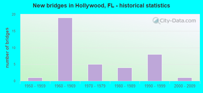
- New bridges - historical statistics
- 11950-1959
- 191960-1969
- 51970-1979
- 41980-1989
- 81990-1999
- 12000-2009

- Reconstructed bridges - Historical Statistics
- 11980-1989
- 51990-1999
- 22000-2009


- Bridge Condition - Deck
- 12.5%Very good
- 66.7%Good
- 12.5%Satisfactory
- 8.3%Fair

- Bridge Condition - Superstructure
- 16.7%Very good
- 50.0%Good
- 16.7%Satisfactory
- 12.5%Fair
- 4.2%Poor

- Bridge Condition - Substructure
- 12.5%Very good
- 79.2%Good
- 8.3%Satisfactory

- Bridge Condition - Channel
- 8.3%Excellent
- 16.7%Very good
- 58.3%Good
- 16.7%Satisfactory
Find on map >> Show street view
Structure Number: 860042, Location: 1 Mile East of US-1 (Lat: 26.034169, Lng: -80.123442), Route carried "on" structure: State highway 822, Year Built: 1962, Status: Open, Structure Length: 3.95m (12.96ft), Average Daily Traffic: 16,600 (year 2020), Truck Traffic: 3%, Average Future Daily Traffic: 28,801 (year 2042), Design Load: HS 20, Features Intersected: West Lake
Minimum Vertical Clearance: 30+ m (98+ ft), Kilometerpoint: 8.488, Lanes on structure: 4, Owner: State Highway Agency, Approaching Roadway Width: 15.8m (51.8ft), Material/Design: Prestressed concrete, Design/Construction: Slab, Number Of Spans In Main Unit: 3, Length of Maximum Span: 13.2m (43.3ft), Curb or Sidewalk Widths: Left: 1.5m (4.9ft), Right: 1.5m (4.9ft), Curb-To-Curb Width: 15.8m (51.8ft), Out-to-Out Width: 20.4m (66.9ft)
Condition: Deck: Fair, Superstructure: Fair, Substructure: Satisfactory, Channel: Very good, Operating Rating: 60.1 metric tons, Method Used To Determine Operating Rating: Load Factor (LF), Inventory Rating: 36.1 metric tons, Method Used To Determine Inventory Rating: Load Factor (LF), Structural Evaluation: Somewhat better than minimum adequacy, Deck Geometry: Meets minimum limits, Waterway Adequacy: Superior to present desirable criteria, Approach Roadway Alignment: Equal to present desirable criteria, Designated Inspection Frequency: Every 24 months, Underwater Inspection Frequency: Every 24 months, Inspection Date: June 2021, Underwater Inspection Date: June 2021, Deck Structure Type: Concrete Precast Panels, Wearing Surface/Protective System: Wearing Surface: Bituminous
Find on map >> Show street view
Structure Number: 860043, Location: Sheridan St & SR-A1A (Lat: 26.034158, Lng: -80.117908), Route carried "on" structure: State highway 822, Year Built: 1962, Status: Open, Structure Length: 10.80m (35.43ft), Average Daily Traffic: 16,600 (year 2020), Truck Traffic: 3%, Average Future Daily Traffic: 28,801 (year 2042), Design Load: HS 20+Mod, Features Intersected: Intracoastal Waterway
Minimum Vertical Clearance: 5.85m (19.19ft), Kilometerpoint: 9.073, Lanes on structure: 4, Owner: State Highway Agency, Approaching Roadway Width: 13.4m (44.0ft), Skew: 20 degrees, Navigation Control: Yes ( Vertical Clearance: 6.7m (22.0ft), Horizontal Clearance: 27.4m (89.9ft)), Material/Design: Steel, Design/Construction: Movable - Bascule, Number Of Spans In Main Unit: 1, Number Of Approach Spans: 4, Length of Maximum Span: 34.1m (111.9ft), Curb or Sidewalk Widths: Left: 1.5m (4.9ft), Right: 1.5m (4.9ft), Curb-To-Curb Width: 13.4m (44.0ft), Out-to-Out Width: 17.6m (57.7ft)
Condition: Deck: Good, Superstructure: Fair, Substructure: Good, Channel: Satisfactory, Operating Rating: 41.0 metric tons, Method Used To Determine Operating Rating: Load Factor (LF), Inventory Rating: 24.6 metric tons, Method Used To Determine Inventory Rating: Load Factor (LF), Structural Evaluation: Somewhat better than minimum adequacy, Deck Geometry: High priority of replacement, Waterway Adequacy: Superior to present desirable criteria, Approach Roadway Alignment: Equal to present minimum criteria, Designated Inspection Frequency: Every 24 months, Critical Feature Inspection Frequency: Every 24 months, Underwater Inspection Frequency: Every 24 months, Other Special Inspection Frequency: Every 12 months, Inspection Date: August 2021, Critical Feature Inspection Date: August 2021, Underwater Inspection Date: August 2021, Other Special Inspection Date: August 2021, Deck Structure Type: Concrete Cast-file-Place
Find on map >> Show street view
Structure Number: 860045, Location: 0.2 MI E OF I-95 ON SR822 (Lat: 26.033181, Lng: -80.161811), Route carried "on" structure: State highway 822, Year Built: 1965, Year Reconstructed: 1995, Status: Open, Structure Length: 4.33m (14.21ft), Average Daily Traffic: 40,000 (year 2021), Truck Traffic: 2%, Average Future Daily Traffic: 69,400 (year 2042), Design Load: HS 20+Mod, Features Intersected: Canal C-10
Minimum Vertical Clearance: 30+ m (98+ ft), Kilometerpoint: 4.677, Lanes on structure: 6, Owner: State Highway Agency, Approaching Roadway Width: 30.4m (99.7ft), Skew: 21 degrees, Navigation Control: Yes ( Vertical Clearance: 2.0m (6.6ft), Horizontal Clearance: 7.6m (24.9ft)), Material/Design: Concrete continuous, Design/Construction: Slab, Number Of Spans In Main Unit: 5, Length of Maximum Span: 8.7m (28.5ft), Curb or Sidewalk Widths: Left: 2.6m (8.5ft), Right: 2.6m (8.5ft), Curb-To-Curb Width: 30.4m (99.7ft), Out-to-Out Width: 37.9m (124.3ft)
Condition: Deck: Good, Superstructure: Good, Substructure: Good, Channel: Very good, Operating Rating: 62.6 metric tons, Method Used To Determine Operating Rating: Load Factor (LF), Inventory Rating: 37.6 metric tons, Method Used To Determine Inventory Rating: Load Factor (LF), Structural Evaluation: Better than present minimum criteria, Deck Geometry: Superior to present desirable criteria, Waterway Adequacy: Superior to present desirable criteria, Approach Roadway Alignment: Equal to present desirable criteria, Designated Inspection Frequency: Every 24 months, Underwater Inspection Frequency: Every 24 months, Inspection Date: September 2021, Underwater Inspection Date: September 2021, Deck Structure Type: Concrete Cast-file-Place
Find on map >> Show street view
Structure Number: 860102, Location: 1MI South of Sheridan St. (Lat: 26.018617, Lng: -80.167528), Route carried "on" structure: Interstate 95, Year Built: 1962, Year Reconstructed: 1990, Status: Open, Structure Length: 4.48m (14.70ft), Average Daily Traffic: 111,000 (year 2020), Truck Traffic: 8%, Average Future Daily Traffic: 192,585 (year 2042), Design Load: HS 20+Mod, Features Intersected: Johnson Street
Minimum Vertical Clearance: 30+ m (98+ ft), Kilometerpoint: 4.933, Lanes on structure: 7, Lanes under structure: 2, Base Highway Network: Yes, Owner: State Highway Agency, Approaching Roadway Width: 25.3m (83.0ft), Material/Design: Prestressed concrete, Design/Construction: Stringer/Multi-beam, Number Of Spans In Main Unit: 3, Length of Maximum Span: 21.6m (70.9ft), Curb-To-Curb Width: 28.8m (94.5ft), Out-to-Out Width: 29.8m (97.8ft)
Condition: Deck: Very good, Superstructure: Good, Substructure: Very good, Operating Rating: 58.4 metric tons, Method Used To Determine Operating Rating: Load and Resistance Factor (LRFR), Inventory Rating: 42.1 metric tons, Method Used To Determine Inventory Rating: Load and Resistance Factor (LRFR), Structural Evaluation: Better than present minimum criteria, Deck Geometry: Meets minimum limits, Underclear: Somewhat better than minimum adequacy, Approach Roadway Alignment: Equal to present desirable criteria, Designated Inspection Frequency: Every 24 months, Inspection Date: December 2021, Deck Structure Type: Concrete Cast-file-Place, Wearing Surface/Protective System: Wearing Surface: Bituminous
Find on map >> Show street view
Structure Number: 860104, Location: 0.5 Mile South of SR-822 (Lat: 26.025806, Lng: -80.166722), Route carried "on" structure: Interstate 95, Year Built: 1964, Year Reconstructed: 1990, Status: Open, Structure Length: 4.16m (13.65ft), Average Daily Traffic: 222,000 (year 2020), Truck Traffic: 8%, Average Future Daily Traffic: 385,170 (year 2042), Design Load: HS 20+Mod, Features Intersected: Taft Street
Minimum Vertical Clearance: 30+ m (98+ ft), Kilometerpoint: 5.761, Lanes on structure: 14, Lanes under structure: 4, Base Highway Network: Yes, Owner: State Highway Agency, Approaching Roadway Width: 58.1m (190.6ft), Skew: 11 degrees, Material/Design: Prestressed concrete, Design/Construction: Stringer/Multi-beam, Number Of Spans In Main Unit: 3, Length of Maximum Span: 20.3m (66.6ft), Curb-To-Curb Width: 58.1m (190.6ft), Out-to-Out Width: 59.5m (195.2ft)
Condition: Deck: Good, Superstructure: Very good, Substructure: Good, Operating Rating: 47.7 metric tons, Method Used To Determine Operating Rating: Load and Resistance Factor (LRFR), Inventory Rating: 31.0 metric tons, Method Used To Determine Inventory Rating: Load and Resistance Factor (LRFR), Structural Evaluation: Better than present minimum criteria, Deck Geometry: Better than present minimum criteria, Underclear: Somewhat better than minimum adequacy, Approach Roadway Alignment: Equal to present desirable criteria, Designated Inspection Frequency: Every 24 months, Inspection Date: April 2020, Deck Structure Type: Concrete Cast-file-Place
Find on map >> Show street view
Structure Number: 860145, Location: 2.1 MI N OF SR-820 (Lat: 26.039358, Lng: -80.213964), Route carried "on" structure: State highway 91, Year Built: 1956, Status: Open, Structure Length: 0.88m (2.89ft), Average Daily Traffic: 13,000 (year 2021), Truck Traffic: 11%, Average Future Daily Traffic: 22,555 (year 2042), Design Load: HL 93, Features Intersected: SEMINOLE DR
Minimum Vertical Clearance: 30+ m (98+ ft), Kilometerpoint: 7.947, Lanes on structure: 6, Base Highway Network: Yes, Toll: On toll road, Owner: State Toll Authority, Approaching Roadway Width: 35.1m (115.2ft), Skew: 30 degrees, Material/Design: Concrete, Design/Construction: Culvert, Number Of Spans In Main Unit: 2, Length of Maximum Span: 4.1m (13.5ft)
Condition: Culverts: Good, Operating Rating: 57.8 metric tons, Method Used To Determine Operating Rating: Load and Resistance Factor (LRFR), Inventory Rating: 44.7 metric tons, Method Used To Determine Inventory Rating: Load and Resistance Factor (LRFR), Structural Evaluation: Better than present minimum criteria, Approach Roadway Alignment: Equal to present desirable criteria, Designated Inspection Frequency: Every 24 months, Inspection Date: September 2021
Find on map >> Show street view
Structure Number: 860147, Location: 0.25 Mi. West of I-95 (Lat: 26.033508, Lng: -80.168194), Route carried "on" structure: State highway 822, Year Built: 1967, Year Reconstructed: 1985, Status: Open, Structure Length: 5.70m (18.70ft), Average Daily Traffic: 47,000 (year 2020), Truck Traffic: 3%, Average Future Daily Traffic: 81,545 (year 2042), Design Load: HS 20, Features Intersected: South FL Rail Corridor
Minimum Vertical Clearance: 30+ m (98+ ft), Kilometerpoint: 4.006, Lanes on structure: 6, Base Highway Network: Yes, Owner: State Highway Agency, Approaching Roadway Width: 24.1m (79.1ft), Skew: 20 degrees, Material/Design: Prestressed concrete, Design/Construction: Stringer/Multi-beam, Number Of Spans In Main Unit: 4, Length of Maximum Span: 18.4m (60.4ft), Curb or Sidewalk Widths: Left: 2.6m (8.5ft), Right: 2.0m (6.6ft), Curb-To-Curb Width: 24.1m (79.1ft), Out-to-Out Width: 33.6m (110.2ft)
Condition: Deck: Satisfactory, Superstructure: Good, Substructure: Good, Operating Rating: 54.7 metric tons, Method Used To Determine Operating Rating: Load Factor (LF), Inventory Rating: 48.4 metric tons, Method Used To Determine Inventory Rating: Load Factor (LF), Structural Evaluation: Better than present minimum criteria, Deck Geometry: Somewhat better than minimum adequacy, Underclear: Meets minimum limits, Approach Roadway Alignment: Equal to present desirable criteria, Designated Inspection Frequency: Every 24 months, Inspection Date: August 2021, Deck Structure Type: Concrete Cast-file-Place
Find on map >> Show street view
Structure Number: 860155, Location: 0.3 Mi. W of US-441 (Lat: 26.032203, Lng: -80.213419), Route carried "on" structure: County highway 822, Year Built: 1965, Status: Open, Structure Length: 5.94m (19.49ft), Average Daily Traffic: 45,800 (year 2021), Truck Traffic: 5%, Average Future Daily Traffic: 57,250 (year 2042), Design Load: HS 20, Features Intersected: FLORIDA'S TURNPIKE
Minimum Vertical Clearance: 30+ m (98+ ft), Kilometerpoint: 0.282, Lanes on structure: 4, Lanes under structure: 6, Base Highway Network: Yes, Owner: County Highway Agency, Approaching Roadway Width: 18.2m (59.7ft), Skew: 20 degrees, Material/Design: Prestressed concrete, Design/Construction: Stringer/Multi-beam, Number Of Spans In Main Unit: 4, Length of Maximum Span: 17.5m (57.4ft), Curb or Sidewalk Widths: Left: 1.5m (4.9ft), Right: 1.5m (4.9ft), Curb-To-Curb Width: 17.1m (56.1ft), Out-to-Out Width: 21.9m (71.9ft)
Condition: Deck: Good, Superstructure: Poor, Substructure: Good, Operating Rating: 48.4 metric tons, Method Used To Determine Operating Rating: Load and Resistance Factor (LRFR), Inventory Rating: 20.1 metric tons, Method Used To Determine Inventory Rating: Load and Resistance Factor (LRFR), Structural Evaluation: Meets minimum limits, Deck Geometry: Somewhat better than minimum adequacy, Underclear: High priority of corrective action, Approach Roadway Alignment: Equal to present desirable criteria, Designated Inspection Frequency: Every 24 months, Other Special Inspection Frequency: Every 3 months, Inspection Date: March 2021, Other Special Inspection Date: December 2021, Deck Structure Type: Concrete Cast-file-Place
Find on map >> Show street view
Structure Number: 860202, Location: 1MI. S of Sheridan St. (Lat: 26.018228, Lng: -80.166964), Route carried "on" structure: Interstate 95, Year Built: 1962, Year Reconstructed: 1990, Status: Open, Structure Length: 4.48m (14.70ft), Average Daily Traffic: 23,500 (year 2020), Truck Traffic: 8%, Average Future Daily Traffic: 40,772 (year 2042), Design Load: HS 20, Features Intersected: Johnson Street
Minimum Vertical Clearance: 30+ m (98+ ft), Kilometerpoint: 4.939, Lanes on structure: 7, Lanes under structure: 2, Base Highway Network: Yes, Owner: State Highway Agency, Approaching Roadway Width: 25.3m (83.0ft), Material/Design: Prestressed concrete, Design/Construction: Stringer/Multi-beam, Number Of Spans In Main Unit: 3, Length of Maximum Span: 21.6m (70.9ft), Curb-To-Curb Width: 28.8m (94.5ft), Out-to-Out Width: 29.8m (97.8ft)
Condition: Deck: Very good, Superstructure: Good, Substructure: Very good, Operating Rating: 58.4 metric tons, Method Used To Determine Operating Rating: Load and Resistance Factor (LRFR), Inventory Rating: 42.1 metric tons, Method Used To Determine Inventory Rating: Load and Resistance Factor (LRFR), Structural Evaluation: Better than present minimum criteria, Deck Geometry: Meets minimum limits, Underclear: Somewhat better than minimum adequacy, Approach Roadway Alignment: Equal to present desirable criteria, Designated Inspection Frequency: Every 24 months, Inspection Date: December 2021, Deck Structure Type: Concrete Cast-file-Place, Wearing Surface/Protective System: Wearing Surface: Bituminous
Find on map >> Show street view
Structure Number: 860228, Location: SR-820 EB & SR-A1A SB (Lat: 26.011267, Lng: -80.117928), Route carried "on" structure: Ramp State highway 820, Year Built: 1976, Status: Open, Structure Length: 13.85m (45.44ft), Average Daily Traffic: 12,133 (year 2020), Truck Traffic: 3%, Average Future Daily Traffic: 21,051 (year 2042), Design Load: HS 20, Features Intersected: SR-820 (Hollywood Blvd.), Facility Carried by Structure: Off Ramp SB SR-A1A
Minimum Vertical Clearance: 30+ m (98+ ft), Kilometerpoint: 0.000, Lanes on structure: 1, Owner: State Highway Agency, Approaching Roadway Width: 6.1m (20.0ft), Material/Design: Steel, Design/Construction: Stringer/Multi-beam, Number Of Spans In Main Unit: 4, Number Of Approach Spans: 7, Length of Maximum Span: 27.1m (88.9ft), Curb or Sidewalk Widths: Left: 0.0m, Right: 1.8m (5.9ft), Curb-To-Curb Width: 6.1m (20.0ft), Out-to-Out Width: 8.7m (28.5ft)
Condition: Deck: Good, Superstructure: Satisfactory, Substructure: Good, Operating Rating: 69.9 metric tons, Method Used To Determine Operating Rating: Load Factor (LF), Inventory Rating: 41.7 metric tons, Method Used To Determine Inventory Rating: Load Factor (LF), Structural Evaluation: Equal to present minimum criteria, Deck Geometry: Somewhat better than minimum adequacy, Approach Roadway Alignment: Equal to present desirable criteria, Designated Inspection Frequency: Every 24 months, Inspection Date: August 2021, Deck Structure Type: Concrete Cast-file-Place
Find on map >> Show street view
Structure Number: 860229, Location: SR-A1A SB to SR-820 WB (Lat: 26.013167, Lng: -80.117792), Route carried "on" structure: Ramp State highway 820, Year Built: 1976, Status: Open, Structure Length: 14.03m (46.03ft), Average Daily Traffic: 12,133 (year 2020), Truck Traffic: 3%, Average Future Daily Traffic: 21,051 (year 2042), Design Load: HS 20, Features Intersected: SR-820 (Hollywood Blvd.)
Minimum Vertical Clearance: 5.09m (16.70ft), Kilometerpoint: 0.035, Lanes on structure: 1, Owner: State Highway Agency, Approaching Roadway Width: 6.1m (20.0ft), Material/Design: Steel, Design/Construction: Stringer/Multi-beam, Number Of Spans In Main Unit: 4, Number Of Approach Spans: 7, Length of Maximum Span: 28.0m (91.9ft), Curb or Sidewalk Widths: Left: 0.0m, Right: 1.8m (5.9ft), Curb-To-Curb Width: 6.1m (20.0ft), Out-to-Out Width: 8.7m (28.5ft)
Condition: Deck: Satisfactory, Superstructure: Satisfactory, Substructure: Good, Operating Rating: 70.0 metric tons, Method Used To Determine Operating Rating: Load Factor (LF), Inventory Rating: 41.6 metric tons, Method Used To Determine Inventory Rating: Load Factor (LF), Structural Evaluation: Equal to present minimum criteria, Deck Geometry: Somewhat better than minimum adequacy, Approach Roadway Alignment: Equal to present desirable criteria, Designated Inspection Frequency: Every 24 months, Inspection Date: August 2021, Deck Structure Type: Concrete Cast-file-Place
Find on map >> Show street view
Structure Number: 86023, Location: SR 820 & Intracoastal (Lat: 26.012083, Lng: -80.119642), Route carried "on" structure: State highway 820, Year Built: 1976, Year Reconstructed: 2007, Status: Open, Structure Length: 39.14m (128.41ft), Average Daily Traffic: 12,133 (year 2020), Truck Traffic: 3%, Average Future Daily Traffic: 21,051 (year 2042), Design Load: HS 20, Features Intersected: Intracoastal Waterway, Facility Carried by Structure: Hollywood Blvd.
Minimum Vertical Clearance: 5.82m (19.09ft), Kilometerpoint: 31.633, Lanes on structure: 4, Lanes under structure: 6, Owner: State Highway Agency, Approaching Roadway Width: 17.0m (55.8ft), Skew: 30 degrees, Navigation Control: Yes ( Vertical Clearance: 6.4m (21.0ft), Horizontal Clearance: 27.4m (89.9ft)), Material/Design: Steel, Design/Construction: Movable - Bascule, Number Of Spans In Main Unit: 1, Number Of Approach Spans: 27, Length of Maximum Span: 34.0m (111.5ft), Curb or Sidewalk Widths: Left: 1.8m (5.9ft), Right: 1.8m (5.9ft), Curb-To-Curb Width: 17.0m (55.8ft), Out-to-Out Width: 18.7m (61.4ft)
Condition: Deck: Good, Superstructure: Satisfactory, Substructure: Good, Channel: Good, Operating Rating: 53.1 metric tons, Method Used To Determine Operating Rating: Load Factor (LF), Inventory Rating: 31.8 metric tons, Method Used To Determine Inventory Rating: Load Factor (LF), Structural Evaluation: Equal to present minimum criteria, Deck Geometry: Somewhat better than minimum adequacy, Underclear: Equal to present minimum criteria, Waterway Adequacy: Superior to present desirable criteria, Approach Roadway Alignment: High priority of corrective action, Designated Inspection Frequency: Every 24 months, Critical Feature Inspection Frequency: Every 24 months, Underwater Inspection Frequency: Every 24 months, Other Special Inspection Frequency: Every 12 months, Inspection Date: August 2021, Critical Feature Inspection Date: August 2021, Underwater Inspection Date: August 2021, Other Special Inspection Date: August 2021, Deck Structure Type: Concrete Cast-file-Place
Find on map >> Show street view
Structure Number: 860403, Location: 0.5 MI NO OF HOLLYWD BLVD (Lat: 26.017556, Lng: -80.212828), Route carried "on" structure: State highway 91, Year Built: 1986, Status: Open, Structure Length: 5.06m (16.60ft), Average Daily Traffic: 13,000 (year 2021), Truck Traffic: 11%, Average Future Daily Traffic: 22,555 (year 2042), Design Load: HS 20+Mod, Features Intersected: JOHNSON ST
Minimum Vertical Clearance: 30+ m (98+ ft), Kilometerpoint: 5.491, Lanes on structure: 6, Lanes under structure: 3, Base Highway Network: Yes, Toll: On toll road, Owner: State Toll Authority, Approaching Roadway Width: 34.1m (111.9ft), Skew: 30 degrees, Material/Design: Prestressed concrete, Design/Construction: Stringer/Multi-beam, Number Of Spans In Main Unit: 3, Length of Maximum Span: 29.6m (97.1ft), Curb-To-Curb Width: 33.5m (109.9ft), Out-to-Out Width: 35.1m (115.2ft)
Condition: Deck: Good, Superstructure: Very good, Substructure: Good, Operating Rating: 46.4 metric tons, Method Used To Determine Operating Rating: Load and Resistance Factor (LRFR), Inventory Rating: 37.9 metric tons, Method Used To Determine Inventory Rating: Load and Resistance Factor (LRFR), Structural Evaluation: Better than present minimum criteria, Deck Geometry: Superior to present desirable criteria, Underclear: Superior to present desirable criteria, Approach Roadway Alignment: Equal to present desirable criteria, Designated Inspection Frequency: Every 24 months, Inspection Date: August 2021, Deck Structure Type: Concrete Cast-file-Place
Find on map >> Show street view
Structure Number: 860404, Location: 1 MI NO.OF HOLLYWOOD BLVD (Lat: 26.024786, Lng: -80.213125), Route carried "on" structure: State highway 91, Year Built: 1986, Status: Open, Structure Length: 4.91m (16.11ft), Average Daily Traffic: 13,000 (year 2021), Truck Traffic: 11%, Average Future Daily Traffic: 22,555 (year 2042), Design Load: HS 20+Mod, Features Intersected: TAFT ST
Minimum Vertical Clearance: 5.15m (16.90ft), Kilometerpoint: 6.296, Lanes on structure: 6, Lanes under structure: 5, Base Highway Network: Yes, Toll: On toll road, Owner: State Toll Authority, Approaching Roadway Width: 26.8m (87.9ft), Skew: 30 degrees, Material/Design: Prestressed concrete, Design/Construction: Stringer/Multi-beam, Number Of Spans In Main Unit: 3, Length of Maximum Span: 28.7m (94.2ft), Curb-To-Curb Width: 26.8m (87.9ft), Out-to-Out Width: 35.1m (115.2ft)
Condition: Deck: Good, Superstructure: Very good, Substructure: Good, Operating Rating: 48.0 metric tons, Method Used To Determine Operating Rating: Load and Resistance Factor (LRFR), Inventory Rating: 36.9 metric tons, Method Used To Determine Inventory Rating: Load and Resistance Factor (LRFR), Structural Evaluation: Better than present minimum criteria, Deck Geometry: Somewhat better than minimum adequacy, Underclear: Superior to present desirable criteria, Approach Roadway Alignment: Equal to present desirable criteria, Designated Inspection Frequency: Every 24 months, Inspection Date: August 2021, Deck Structure Type: Concrete Cast-file-Place
Find on map >> Show street view
Structure Number: 86053, Location: I-95 over Hollywood Blvd (Lat: 26.010922, Lng: -80.166775), Route carried "on" structure: Interstate 95, Year Built: 1990, Year Reconstructed: 2013, Status: Open, Structure Length: 7.44m (24.41ft), Average Daily Traffic: 19,500 (year 2020), Truck Traffic: 8%, Average Future Daily Traffic: 33,832 (year 2042), Design Load: HS 20+Mod, Features Intersected: SR-820 Hollywood Blvd
Minimum Vertical Clearance: 30+ m (98+ ft), Kilometerpoint: 4.089, Lanes on structure: 12, Lanes under structure: 10, Base Highway Network: Yes, Owner: State Highway Agency, Approaching Roadway Width: 55.4m (181.8ft), Skew: 30 degrees, Material/Design: Prestressed concrete, Design/Construction: Stringer/Multi-beam, Number Of Spans In Main Unit: 4, Length of Maximum Span: 25.6m (84.0ft), Curb-To-Curb Width: 55.4m (181.8ft), Out-to-Out Width: 56.9m (186.7ft)
Condition: Deck: Good, Superstructure: Good, Substructure: Very good, Operating Rating: 51.9 metric tons, Method Used To Determine Operating Rating: Load and Resistance Factor (LRFR), Inventory Rating: 39.8 metric tons, Method Used To Determine Inventory Rating: Load and Resistance Factor (LRFR), Structural Evaluation: Better than present minimum criteria, Deck Geometry: Superior to present desirable criteria, Underclear: Equal to present minimum criteria, Approach Roadway Alignment: Equal to present desirable criteria, Designated Inspection Frequency: Every 24 months, Inspection Date: August 2021, Deck Structure Type: Concrete Cast-file-Place
Find on map >> Show street view
Structure Number: 860574, Location: 0.68 Mi S of Sheridan I95 (Lat: 26.023936, Lng: -80.167356), Route carried "on" structure: Interstate 95, Year Built: 1990, Status: Open, Structure Length: 3.60m (11.81ft), Average Daily Traffic: 111,000 (year 2020), Truck Traffic: 8%, Average Future Daily Traffic: 192,585 (year 2042), Design Load: HS 20+Mod, Features Intersected: C-10 Hollywood Canal
Minimum Vertical Clearance: 30+ m (98+ ft), Kilometerpoint: 5.544, Lanes on structure: 7, Base Highway Network: Yes, Owner: State Highway Agency, Approaching Roadway Width: 28.9m (94.8ft), Skew: 1 degrees, Navigation Control: Yes ( Vertical Clearance: 4.1m (13.5ft), Horizontal Clearance: 12.3m (40.4ft)), Material/Design: Prestressed concrete, Design/Construction: Stringer/Multi-beam, Number Of Spans In Main Unit: 3, Length of Maximum Span: 13.4m (44.0ft), Curb-To-Curb Width: 28.9m (94.8ft), Out-to-Out Width: 29.9m (98.1ft)
Condition: Deck: Good, Superstructure: Very good, Substructure: Good, Channel: Good, Operating Rating: 42.8 metric tons, Method Used To Determine Operating Rating: Load and Resistance Factor (LRFR), Inventory Rating: 33.0 metric tons, Method Used To Determine Inventory Rating: Load and Resistance Factor (LRFR), Structural Evaluation: Better than present minimum criteria, Deck Geometry: Meets minimum limits, Waterway Adequacy: Superior to present desirable criteria, Approach Roadway Alignment: Equal to present desirable criteria, Designated Inspection Frequency: Every 24 months, Underwater Inspection Frequency: Every 24 months, Inspection Date: May 2021, Underwater Inspection Date: May 2021, Deck Structure Type: Concrete Cast-file-Place
Find on map >> Show street view
Structure Number: 860575, Location: 0.68 Mi S of Sheridan I95 (Lat: 26.023944, Lng: -80.167017), Route carried "on" structure: Interstate 95, Year Built: 1990, Status: Open, Structure Length: 3.60m (11.81ft), Average Daily Traffic: 111,000 (year 2020), Truck Traffic: 8%, Average Future Daily Traffic: 192,585 (year 2042), Design Load: HS 20+Mod, Features Intersected: C-10 Hollywood canal
Minimum Vertical Clearance: 30+ m (98+ ft), Kilometerpoint: 5.544, Lanes on structure: 7, Base Highway Network: Yes, Owner: State Highway Agency, Approaching Roadway Width: 25.3m (83.0ft), Skew: 1 degrees, Navigation Control: Yes ( Vertical Clearance: 4.1m (13.5ft), Horizontal Clearance: 12.3m (40.4ft)), Material/Design: Prestressed concrete, Design/Construction: Stringer/Multi-beam, Number Of Spans In Main Unit: 3, Length of Maximum Span: 13.4m (44.0ft), Curb-To-Curb Width: 28.9m (94.8ft), Out-to-Out Width: 29.9m (98.1ft)
Condition: Deck: Good, Superstructure: Good, Substructure: Good, Channel: Good, Operating Rating: 42.8 metric tons, Method Used To Determine Operating Rating: Load and Resistance Factor (LRFR), Inventory Rating: 33.0 metric tons, Method Used To Determine Inventory Rating: Load and Resistance Factor (LRFR), Structural Evaluation: Better than present minimum criteria, Deck Geometry: Meets minimum limits, Waterway Adequacy: Superior to present desirable criteria, Approach Roadway Alignment: Equal to present desirable criteria, Designated Inspection Frequency: Every 24 months, Underwater Inspection Frequency: Every 24 months, Inspection Date: May 2021, Underwater Inspection Date: May 2021, Deck Structure Type: Concrete Cast-file-Place
Find on map >> Show street view
Structure Number: 860576, Location: SB I-95 over Sheridan St. (Lat: 26.033328, Lng: -80.164475), Route carried "on" structure: Interstate 95, Year Built: 1990, Status: Open, Structure Length: 5.47m (17.95ft), Average Daily Traffic: 111,000 (year 2020), Truck Traffic: 8%, Average Future Daily Traffic: 192,585 (year 2042), Design Load: HS 20+Mod, Features Intersected: SR-822 (Sheridan St.)
Minimum Vertical Clearance: 30+ m (98+ ft), Kilometerpoint: 6.618, Lanes on structure: 6, Lanes under structure: 10, Base Highway Network: Yes, Owner: State Highway Agency, Approaching Roadway Width: 25.3m (83.0ft), Skew: 1 degrees, Material/Design: Prestressed concrete, Design/Construction: Stringer/Multi-beam, Number Of Spans In Main Unit: 2, Length of Maximum Span: 27.4m (89.9ft), Curb-To-Curb Width: 25.3m (83.0ft), Out-to-Out Width: 26.1m (85.6ft)
Condition: Deck: Very good, Superstructure: Good, Substructure: Good, Operating Rating: 69.2 metric tons, Method Used To Determine Operating Rating: Load and Resistance Factor (LRFR), Inventory Rating: 57.8 metric tons, Method Used To Determine Inventory Rating: Load and Resistance Factor (LRFR), Structural Evaluation: Better than present minimum criteria, Deck Geometry: Meets minimum limits, Underclear: Somewhat better than minimum adequacy, Approach Roadway Alignment: Equal to present desirable criteria, Designated Inspection Frequency: Every 24 months, Inspection Date: May 2021, Deck Structure Type: Concrete Cast-file-Place
Find on map >> Show street view
Structure Number: 860577, Location: NB I-95 over Sheridan St. (Lat: 26.033319, Lng: -80.164208), Route carried "on" structure: Interstate 95, Year Built: 1990, Status: Open, Structure Length: 5.47m (17.95ft), Average Daily Traffic: 111,000 (year 2020), Truck Traffic: 8%, Average Future Daily Traffic: 192,585 (year 2042), Design Load: HS 20+Mod, Features Intersected: SR-822 (Sheridan St.)
Minimum Vertical Clearance: 30+ m (98+ ft), Kilometerpoint: 6.618, Lanes on structure: 6, Lanes under structure: 10, Base Highway Network: Yes, Owner: State Highway Agency, Approaching Roadway Width: 25.3m (83.0ft), Skew: 1 degrees, Material/Design: Prestressed concrete, Design/Construction: Stringer/Multi-beam, Number Of Spans In Main Unit: 2, Length of Maximum Span: 27.4m (89.9ft), Curb-To-Curb Width: 25.3m (83.0ft), Out-to-Out Width: 26.1m (85.6ft)
Condition: Deck: Good, Superstructure: Good, Substructure: Good, Operating Rating: 69.2 metric tons, Method Used To Determine Operating Rating: Load and Resistance Factor (LRFR), Inventory Rating: 57.8 metric tons, Method Used To Determine Inventory Rating: Load and Resistance Factor (LRFR), Structural Evaluation: Better than present minimum criteria, Deck Geometry: Meets minimum limits, Underclear: Somewhat better than minimum adequacy, Approach Roadway Alignment: Equal to present desirable criteria, Designated Inspection Frequency: Every 24 months, Inspection Date: May 2021, Deck Structure Type: Concrete Cast-file-Place
Find on map >> Show street view
Structure Number: 860578, Location: I-95 0.25mi N of Sheridan (Lat: 26.040672, Lng: -80.163314), Route carried "on" structure: Interstate 95, Year Built: 1962, Year Reconstructed: 1990, Status: Open, Structure Length: 3.11m (10.20ft), Average Daily Traffic: 218,000 (year 2020), Truck Traffic: 8%, Average Future Daily Traffic: 378,230 (year 2042), Design Load: HS 20+Mod, Features Intersected: C-10 Spur Canal
Minimum Vertical Clearance: 30+ m (98+ ft), Kilometerpoint: 7.448, Lanes on structure: 13, Base Highway Network: Yes, Owner: State Highway Agency, Approaching Roadway Width: 50.7m (166.3ft), Skew: 30 degrees, Material/Design: Concrete continuous, Design/Construction: Slab, Number Of Spans In Main Unit: 3, Length of Maximum Span: 10.4m (34.1ft), Curb-To-Curb Width: 58.1m (190.6ft), Out-to-Out Width: 59.6m (195.5ft)
Condition: Deck: Satisfactory, Superstructure: Satisfactory, Substructure: Good, Channel: Excellent, Operating Rating: 43.1 metric tons, Method Used To Determine Operating Rating: Load and Resistance Factor (LRFR), Inventory Rating: 33.3 metric tons, Method Used To Determine Inventory Rating: Load and Resistance Factor (LRFR), Structural Evaluation: Equal to present minimum criteria, Deck Geometry: Superior to present desirable criteria, Waterway Adequacy: Superior to present desirable criteria, Approach Roadway Alignment: Equal to present desirable criteria, Designated Inspection Frequency: Every 24 months, Underwater Inspection Frequency: Every 24 months, Inspection Date: May 2021, Underwater Inspection Date: May 2021, Deck Structure Type: Concrete Cast-file-Place
Find on map >> Show street view
Structure Number: 866301, Location: 0.5MI N OF SHERIDAN ST. (Lat: 26.040589, Lng: -80.165831), Route carried "on" structure: City street 29, Year Built: 1967, Status: Posted for load-capacity, Structure Length: 0.96m (3.15ft), Average Daily Traffic: 10,634 (year 2021), Truck Traffic: 5%, Average Future Daily Traffic: 18,450 (year 2041), Features Intersected: C-10 SPUR CANAL
Minimum Vertical Clearance: 30+ m (98+ ft), Kilometerpoint: 0.814, Lanes on structure: 4, Owner: City or Municipal Highway Agency, Approaching Roadway Width: 15.4m (50.5ft), Material/Design: Prestressed concrete, Design/Construction: Slab, Number Of Spans In Main Unit: 1, Length of Maximum Span: 9.6m (31.5ft), Curb or Sidewalk Widths: Left: 1.3m (4.3ft), Right: 1.3m (4.3ft), Curb-To-Curb Width: 15.4m (50.5ft), Out-to-Out Width: 18.6m (61.0ft)
Condition: Deck: Fair, Superstructure: Fair, Substructure: Good, Channel: Satisfactory, Operating Rating: 45.4 metric tons, Method Used To Determine Operating Rating: Load Factor (LF), Inventory Rating: 27.2 metric tons, Method Used To Determine Inventory Rating: Load Factor (LF), Structural Evaluation: Somewhat better than minimum adequacy, Deck Geometry: Meets minimum limits, Waterway Adequacy: Better than present minimum criteria, Approach Roadway Alignment: Equal to present desirable criteria, Designated Inspection Frequency: Every 24 months, Underwater Inspection Frequency: Every 24 months, Inspection Date: March 2021, Underwater Inspection Date: March 2021, Deck Structure Type: Concrete Precast Panels, Wearing Surface/Protective System: Wearing Surface: Bituminous
Find on map >> Show street view
Structure Number: 866302, Location: 0.3MI E of CASPER COURT (Lat: 26.037225, Lng: -80.187919), Route carried "on" structure: City street , Year Built: 1968, Status: Posted for load-capacity, Structure Length: 1.95m (6.40ft), Average Daily Traffic: 500 (year 2021), Truck Traffic: 2%, Average Future Daily Traffic: 868 (year 2041), Design Load: H 20, Features Intersected: C10 SPUR CANAL, Facility Carried by Structure: SANDERS ST.
Minimum Vertical Clearance: 30+ m (98+ ft), Kilometerpoint: 0.000, Lanes on structure: 2, Owner: City or Municipal Highway Agency, Approaching Roadway Width: 6.5m (21.3ft), Material/Design: Concrete, Design/Construction: Slab, Number Of Spans In Main Unit: 3, Length of Maximum Span: 7.9m (25.9ft), Curb or Sidewalk Widths: Left: 0.9m (3.0ft), Right: 0.9m (3.0ft), Curb-To-Curb Width: 7.4m (24.3ft), Out-to-Out Width: 10.9m (35.8ft)
Condition: Deck: Good, Superstructure: Good, Substructure: Good, Channel: Good, Operating Rating: 46.0 metric tons, Method Used To Determine Operating Rating: Load Factor (LF), Inventory Rating: 27.6 metric tons, Method Used To Determine Inventory Rating: Load Factor (LF), Structural Evaluation: Equal to present minimum criteria, Deck Geometry: Meets minimum limits, Waterway Adequacy: Equal to present desirable criteria, Approach Roadway Alignment: Equal to present desirable criteria, Designated Inspection Frequency: Every 24 months, Underwater Inspection Frequency: Every 24 months, Inspection Date: March 2021, Underwater Inspection Date: March 2021, Deck Structure Type: Concrete Precast Panels, Wearing Surface/Protective System: Wearing Surface: Bituminous
Find on map >> Show street view
Structure Number: 866303, Location: 0.1MI EAST OF N 28TH AVE (Lat: 26.032319, Lng: -80.161794), Route carried "on" structure: City street , Year Built: 1963, Status: Open, Structure Length: 1.74m (5.71ft), Average Daily Traffic: 1,100 (year 2021), Truck Traffic: 3%, Average Future Daily Traffic: 1,909 (year 2042), Design Load: H 20, Features Intersected: C-10 CANAL, Facility Carried by Structure: SHERMAN STREET
Minimum Vertical Clearance: 30+ m (98+ ft), Kilometerpoint: 0.000, Lanes on structure: 2, Owner: City or Municipal Highway Agency, Approaching Roadway Width: 7.3m (24.0ft), Skew: 1 degrees, Material/Design: Prestressed concrete, Design/Construction: Slab, Number Of Spans In Main Unit: 3, Length of Maximum Span: 7.9m (25.9ft), Curb or Sidewalk Widths: Left: 0.2m (0.7ft), Right: 1.2m (3.9ft), Curb-To-Curb Width: 7.3m (24.0ft), Out-to-Out Width: 9.4m (30.8ft)
Condition: Deck: Good, Superstructure: Good, Substructure: Good, Channel: Good, Operating Rating: 66.1 metric tons, Method Used To Determine Operating Rating: Load Factor (LF), Inventory Rating: 39.7 metric tons, Method Used To Determine Inventory Rating: Load Factor (LF), Structural Evaluation: Better than present minimum criteria, Deck Geometry: Meets minimum limits, Waterway Adequacy: Equal to present desirable criteria, Approach Roadway Alignment: Equal to present desirable criteria, Designated Inspection Frequency: Every 24 months, Underwater Inspection Frequency: Every 24 months, Inspection Date: Febuary 2021, Underwater Inspection Date: Febuary 2021, Deck Structure Type: Concrete Precast Panels, Wearing Surface/Protective System: Wearing Surface: Bituminous
Find on map >> Show street view
Structure Number: 866304, Location: 0.1MI E OF NORTH 28TH AVE (Lat: 26.025886, Lng: -80.163367), Route carried "on" structure: City street , Year Built: 1962, Status: Posted for load-capacity, Structure Length: 1.71m (5.61ft), Average Daily Traffic: 10,900 (year 2021), Truck Traffic: 2%, Average Future Daily Traffic: 17,350 (year 2042), Features Intersected: C-10 CANAL, Facility Carried by Structure: TAFT ST
Minimum Vertical Clearance: 30+ m (98+ ft), Kilometerpoint: 0.332, Lanes on structure: 2, Owner: City or Municipal Highway Agency, Approaching Roadway Width: 8.8m (28.9ft), Material/Design: Prestressed concrete, Design/Construction: Slab, Number Of Spans In Main Unit: 3, Length of Maximum Span: 7.9m (25.9ft), Curb or Sidewalk Widths: Left: 1.2m (3.9ft), Right: 1.1m (3.6ft), Curb-To-Curb Width: 8.8m (28.9ft), Out-to-Out Width: 12.2m (40.0ft)
Condition: Deck: Good, Superstructure: Good, Substructure: Good, Channel: Good, Operating Rating: 50.3 metric tons, Method Used To Determine Operating Rating: Load Factor (LF), Inventory Rating: 30.2 metric tons, Method Used To Determine Inventory Rating: Load Factor (LF), Structural Evaluation: Better than present minimum criteria, Deck Geometry: High priority of replacement, Waterway Adequacy: Better than present minimum criteria, Approach Roadway Alignment: Better than present minimum criteria, Designated Inspection Frequency: Every 24 months, Underwater Inspection Frequency: Every 24 months, Inspection Date: Febuary 2021, Underwater Inspection Date: Febuary 2021, Deck Structure Type: Concrete Precast Panels, Wearing Surface/Protective System: Wearing Surface: Bituminous
Find on map >> Show street view
Structure Number: 866305, Location: 130FT. W OF N 30TH ROAD (Lat: 26.018375, Lng: -80.169875), Route carried "on" structure: City street , Year Built: 1965, Status: Posted for load-capacity, Structure Length: 1.71m (5.61ft), Average Daily Traffic: 10,900 (year 2021), Truck Traffic: 2%, Average Future Daily Traffic: 17,350 (year 2042), Design Load: H 20, Features Intersected: C-10 CANAL, Facility Carried by Structure: JOHNSON ST.
Minimum Vertical Clearance: 30+ m (98+ ft), Kilometerpoint: 3.813, Lanes on structure: 3, Owner: City or Municipal Highway Agency, Approaching Roadway Width: 11.0m (36.1ft), Material/Design: Prestressed concrete, Design/Construction: Slab, Number Of Spans In Main Unit: 3, Length of Maximum Span: 7.9m (25.9ft), Curb or Sidewalk Widths: Left: 1.2m (3.9ft), Right: 1.2m (3.9ft), Curb-To-Curb Width: 11.0m (36.1ft), Out-to-Out Width: 16.5m (54.1ft)
Condition: Deck: Good, Superstructure: Good, Substructure: Satisfactory, Channel: Good, Operating Rating: 53.3 metric tons, Method Used To Determine Operating Rating: Load Factor (LF), Inventory Rating: 31.9 metric tons, Method Used To Determine Inventory Rating: Load Factor (LF), Structural Evaluation: Equal to present minimum criteria, Deck Geometry: High priority of replacement, Waterway Adequacy: Better than present minimum criteria, Approach Roadway Alignment: Equal to present desirable criteria, Designated Inspection Frequency: Every 24 months, Underwater Inspection Frequency: Every 24 months, Inspection Date: Febuary 2021, Underwater Inspection Date: Febuary 2021, Deck Structure Type: Concrete Precast Panels, Wearing Surface/Protective System: Wearing Surface: Bituminous
Find on map >> Show street view
Structure Number: 860102, Location: 1MI South of Sheridan St. (Lat: 26.018617, Lng: -80.167528), Route carried "under" structure: City street , Year Built: 1962, Structure Length: 0. m, Average Daily Traffic: 14,200 (year 2020), Truck Traffic: 9%, Features Intersected: Johnson Street, Facility Carried by Structure: I-95 (SR-9) SB
Minimum Vertical Clearance: 4.42m (14.50ft), Kilometerpoint: 4.048, Lanes on structure: 7, Lanes under structure: 2, Material/Design: Prestressed concrete, Design/Construction: Stringer/Multi-beam, Length of Maximum Span: 21.6m (70.9ft)
Find on map >> Show street view
Structure Number: 860104, Location: 0.5 Mile South of SR-822 (Lat: 26.025806, Lng: -80.166722), Route carried "under" structure: City street , Year Built: 1964, Structure Length: 0. m, Average Daily Traffic: 3,900 (year 2020), Truck Traffic: 9%, Features Intersected: Taft Street, Facility Carried by Structure: I-95 (SR-9)
Minimum Vertical Clearance: 4.72m (15.49ft), Kilometerpoint: 0.000, Lanes on structure: 14, Lanes under structure: 2, Material/Design: Prestressed concrete, Design/Construction: Stringer/Multi-beam, Length of Maximum Span: 20.3m (66.6ft)
Find on map >> Show street view
Structure Number: 860104, Location: 0.5 Mile South of SR-822 (Lat: 26.025806, Lng: -80.166722), Route carried "under" structure: City street , Year Built: 1964, Structure Length: 0. m, Average Daily Traffic: 8,400 (year 2020), Truck Traffic: 9%, Features Intersected: Taft Street, Facility Carried by Structure: I-95 (SR-9)
Minimum Vertical Clearance: 4.72m (15.49ft), Kilometerpoint: 4.622, Lanes on structure: 14, Lanes under structure: 2, Material/Design: Prestressed concrete, Design/Construction: Stringer/Multi-beam, Length of Maximum Span: 20.3m (66.6ft)
Find on map >> Show street view
Structure Number: 860155, Location: 0.3 Mi. W of US-441 (Lat: 26.032203, Lng: -80.213419), Route carried "under" structure: Other road 91, Year Built: 1965, Structure Length: 0. m, Average Daily Traffic: 79,400 (year 2021), Truck Traffic: 5%, Features Intersected: FLORIDA'S TURNPIKE, Facility Carried by Structure: SHERIDAN ST(CR822)
Minimum Vertical Clearance: 4.54m (14.90ft), Kilometerpoint: 7.128, Lanes on structure: 4, Lanes under structure: 6, Toll: On toll road, Material/Design: Prestressed concrete, Design/Construction: Stringer/Multi-beam, Length of Maximum Span: 17.5m (57.4ft)
Find on map >> Show street view
Structure Number: 860202, Location: 1MI. S of Sheridan St. (Lat: 26.018228, Lng: -80.166964), Route carried "under" structure: City street , Year Built: 1962, Structure Length: 0. m, Average Daily Traffic: 8,600 (year 2020), Truck Traffic: 9%, Features Intersected: Johnson Street, Facility Carried by Structure: I-95 ( SR-9 ) NB
Minimum Vertical Clearance: 4.42m (14.50ft), Kilometerpoint: 0.002, Lanes on structure: 7, Lanes under structure: 2, Material/Design: Prestressed concrete, Design/Construction: Stringer/Multi-beam, Length of Maximum Span: 21.6m (70.9ft)
Find on map >> Show street view
Structure Number: 86023, Location: SR 820 & Intracoastal (Lat: 26.012083, Lng: -80.119642), Route carried "under" structure: ServiceCity street , Year Built: 1976, Structure Length: 0. m, Average Daily Traffic: 20 (year 2019), Features Intersected: Intracoastal Waterway, Facility Carried by Structure: Hollywood Blvd.
Minimum Vertical Clearance: 5.12m (16.80ft), Kilometerpoint: 0.000, Lanes on structure: 4, Lanes under structure: 1, Material/Design: Steel, Design/Construction: Movable - Bascule, Length of Maximum Span: 34.0m (111.5ft)
Find on map >> Show street view
Structure Number: 86023, Location: SR 820 & Intracoastal (Lat: 26.012083, Lng: -80.119642), Route carried "under" structure: State highway A1A, Year Built: 1976, Structure Length: 0. m, Average Daily Traffic: 27,000 (year 2020), Truck Traffic: 4%, Features Intersected: Intracoastal Waterway, Facility Carried by Structure: Hollywood Blvd.
Minimum Vertical Clearance: 5.82m (19.09ft), Kilometerpoint: 4.120, Lanes on structure: 4, Lanes under structure: 5, Material/Design: Steel, Design/Construction: Movable - Bascule, Length of Maximum Span: 34.0m (111.5ft)
Find on map >> Show street view
Structure Number: 860403, Location: 0.5 MI NO OF HOLLYWD BLVD (Lat: 26.017556, Lng: -80.212828), Route carried "under" structure: City street , Year Built: 1986, Structure Length: 0. m, Average Daily Traffic: 13,000 (year 2021), Truck Traffic: 11%, Features Intersected: JOHNSON ST, Facility Carried by Structure: SR91 N/S TPK 50.66
Minimum Vertical Clearance: 5.27m (17.29ft), Kilometerpoint: 5.491, Lanes on structure: 6, Lanes under structure: 3, Material/Design: Prestressed concrete, Design/Construction: Stringer/Multi-beam, Length of Maximum Span: 29.6m (97.1ft)
Find on map >> Show street view
Structure Number: 860404, Location: 1 MI NO.OF HOLLYWOOD BLVD (Lat: 26.024786, Lng: -80.213125), Route carried "under" structure: City street , Year Built: 1986, Structure Length: 0. m, Average Daily Traffic: 13,000 (year 2021), Truck Traffic: 11%, Features Intersected: TAFT ST, Facility Carried by Structure: SR91 N/S TPK 51.14
Minimum Vertical Clearance: 5.27m (17.29ft), Kilometerpoint: 6.296, Lanes on structure: 6, Lanes under structure: 4, Material/Design: Prestressed concrete, Design/Construction: Stringer/Multi-beam, Length of Maximum Span: 28.7m (94.2ft)
Find on map >> Show street view
Structure Number: 86053, Location: I-95 over Hollywood Blvd (Lat: 26.010922, Lng: -80.166775), Route carried "under" structure: State highway 820, Year Built: 1990, Structure Length: 0. m, Average Daily Traffic: 44,000 (year 2020), Truck Traffic: 5%, Features Intersected: SR-820 Hollywood Blvd, Facility Carried by Structure: I-95 (SR-9)
Minimum Vertical Clearance: 5.12m (16.80ft), Kilometerpoint: 26.675, Lanes on structure: 12, Lanes under structure: 10, Material/Design: Prestressed concrete, Design/Construction: Stringer/Multi-beam, Length of Maximum Span: 25.6m (84.0ft)
Find on map >> Show street view
Structure Number: 860576, Location: SB I-95 over Sheridan St. (Lat: 26.033328, Lng: -80.164475), Route carried "under" structure: State highway 822, Year Built: 1990, Structure Length: 0. m, Average Daily Traffic: 40,000 (year 2020), Truck Traffic: 2%, Features Intersected: SR-822 (Sheridan St.), Facility Carried by Structure: SB I-95 (SR-9)
Minimum Vertical Clearance: 4.97m (16.31ft), Kilometerpoint: 4.422, Lanes on structure: 6, Lanes under structure: 10, Material/Design: Prestressed concrete, Design/Construction: Stringer/Multi-beam, Length of Maximum Span: 27.4m (89.9ft)
Find on map >> Show street view
Structure Number: 860577, Location: NB I-95 over Sheridan St. (Lat: 26.033319, Lng: -80.164208), Route carried "under" structure: State highway 822, Year Built: 1990, Structure Length: 0. m, Average Daily Traffic: 40,000 (year 2020), Truck Traffic: 2%, Features Intersected: SR-822 (Sheridan St.), Facility Carried by Structure: NB I-95 (SR-9)
Minimum Vertical Clearance: 4.97m (16.31ft), Kilometerpoint: 4.397, Lanes on structure: 6, Lanes under structure: 10, Material/Design: Prestressed concrete, Design/Construction: Stringer/Multi-beam, Length of Maximum Span: 27.4m (89.9ft)
Find on map >> Show street view
Structure Number: 869902, Location: .6m N of Hallandale Blvd. (Lat: 25.991658, Lng: -80.118903), Route carried "under" structure: State highway A1A, Year Built: 2002, Structure Length: 0. m, Average Daily Traffic: 275,000 (year 2021), Truck Traffic: 3%, Features Intersected: SR-A1A, Facility Carried by Structure: PedestrianOverpass
Minimum Vertical Clearance: 5.91m (19.39ft), Kilometerpoint: 1.839, Lanes under structure: 6, Material/Design: Steel, Design/Construction: Truss - Thru, Length of Maximum Span: 56.3m (184.7ft)