Bridge Statistics for Hollymead, Virginia (VA)
Condition, Traffic, Stress, Structural Evaluation, Project Costs
- National Bridge Inventory (NBI) Statistics
- 20Number of bridges
- 371ft / 113mTotal length
- $2,411,000Total costs
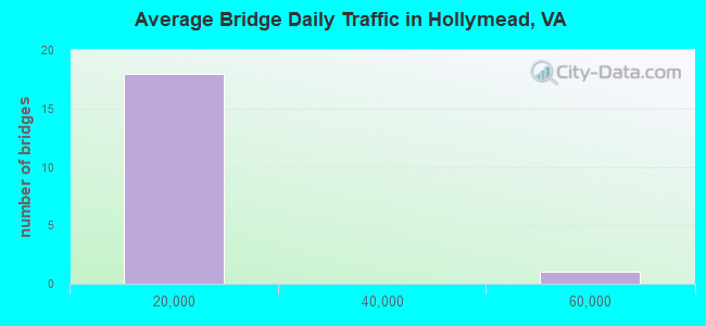
- 154,105Total average daily traffic
- 4,670Total average daily truck traffic
- National Bridge Inventory (NBI) Registered Bridges for Hollymead
- No street view available for this location
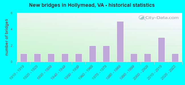
- New bridges - historical statistics
- 11910-1919
- 11920-1929
- 11930-1939
- 11940-1949
- 11950-1959
- 21960-1969
- 21970-1979
- 51980-1989
- 11990-1999
- 12000-2009
- 32010-2019
- 12020-2022
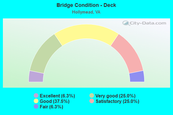
- Bridge Condition - Deck
- 6.3%Excellent
- 25.0%Very good
- 37.5%Good
- 25.0%Satisfactory
- 6.3%Fair
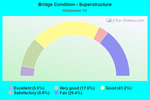
- Bridge Condition - Superstructure
- 5.9%Excellent
- 17.6%Very good
- 41.2%Good
- 5.9%Satisfactory
- 29.4%Fair
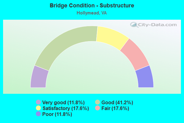
- Bridge Condition - Substructure
- 11.8%Very good
- 41.2%Good
- 17.6%Satisfactory
- 17.6%Fair
- 11.8%Poor
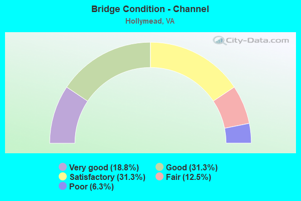
- Bridge Condition - Channel
- 18.8%Very good
- 31.3%Good
- 31.3%Satisfactory
- 12.5%Fair
- 6.3%Poor
Find on map >> Show street view
Structure Number: 315, Location: 00.44FR27/00.75TO BOUNDRY (Lat: 38.866375, Lng: -77.054592), Route carried "on" structure: Interstate 395, Year Built: 1976, Status: Open, Structure Length: 6.22m (20.41ft), Average Daily Traffic: 55,203 (year 2020), Truck Traffic: 3%, Average Future Daily Traffic: 77,284 (year 2040), Design Load: HS 20, Features Intersected: EADS ST. & RAMPS A & C
Minimum Vertical Clearance: 30+ m (98+ ft), Kilometerpoint: 14.690, Lanes on structure: 5, Lanes under structure: 4, Base Highway Network: Yes, Owner: State Highway Agency, Approaching Roadway Width: 27.7m (90.9ft), Material/Design: Steel, Design/Construction: Stringer/Multi-beam, Number Of Spans In Main Unit: 2, Length of Maximum Span: 31.1m (102.0ft), Curb or Sidewalk Widths: Left: 0.2m (0.7ft), Right: 0.2m (0.7ft), Curb-To-Curb Width: 27.1m (88.9ft), Out-to-Out Width: 28.3m (92.8ft)
Condition: Deck: Satisfactory, Superstructure: Fair, Substructure: Fair, Operating Rating: 69.9 metric tons, Method Used To Determine Operating Rating: Load and Resistance Factor (LRFR), Inventory Rating: 53.9 metric tons, Method Used To Determine Inventory Rating: Load and Resistance Factor (LRFR), Structural Evaluation: Somewhat better than minimum adequacy, Deck Geometry: Superior to present desirable criteria, Underclear: Equal to present minimum criteria, Approach Roadway Alignment: Equal to present desirable criteria, Length Of Structure Improvement: 6.22m (20.41ft), Designated Inspection Frequency: Every 24 months, Inspection Date: August 2021, Bridge Improvement Cost: $36,000, Roadway Improvement Cost: $4,000, Total Project Cost: $50,000, Deck Structure Type: Concrete Cast-file-Place, Wearing Surface/Protective System: Wearing Surface: Epoxy Overlay
Find on map >> Show street view
Structure Number: 427, Location: 0.50 FR 610 / 0.25 TO 649 (Lat: 38.082111, Lng: -78.404708), Route carried "on" structure: State highway 20, Year Built: 1984, Status: Open, Structure Length: 0.67m (2.20ft), Average Daily Traffic: 7,216 (year 2020), Truck Traffic: 3%, Average Future Daily Traffic: 10,102 (year 2040), Design Load: HS 20+Mod, Features Intersected: STREAM, Facility Carried by Structure: STONY POINT ROAD
Minimum Vertical Clearance: 30+ m (98+ ft), Kilometerpoint: 72.094, Lanes on structure: 2, Base Highway Network: Yes, Owner: State Highway Agency, Approaching Roadway Width: 7.3m (24.0ft), Skew: 2 degrees, Material/Design: Concrete, Design/Construction: Culvert, Number Of Spans In Main Unit: 3, Length of Maximum Span: 2.1m (6.9ft)
Condition: Channel: Satisfactory, Culverts: Good, Operating Rating: 44.5 metric tons, Method Used To Determine Operating Rating: Field evaluation and documented engineering judgment, Inventory Rating: 32.7 metric tons, Method Used To Determine Inventory Rating: Field evaluation and documented engineering judgment, Structural Evaluation: Better than present minimum criteria, Waterway Adequacy: Equal to present minimum criteria, Approach Roadway Alignment: Equal to present minimum criteria, Designated Inspection Frequency: Every 24 months, Inspection Date: May 2021
Find on map >> Show street view
Structure Number: 463, Location: 1.64FR649&3.10TO GREENECL (Lat: 38.152100, Lng: -78.422325), Route carried "on" structure: US 29, Year Built: 1984, Status: Open, Structure Length: 7.74m (25.39ft), Average Daily Traffic: 15,994 (year 2020), Truck Traffic: 3%, Average Future Daily Traffic: 22,393 (year 2040), Design Load: HS 20+Mod, Features Intersected: NORTH FORK RIVANNA RIVER, Facility Carried by Structure: SEMINOLE TRAIL SBL
Minimum Vertical Clearance: 30+ m (98+ ft), Kilometerpoint: 234.978, Lanes on structure: 2, Base Highway Network: Yes, Owner: State Highway Agency, Approaching Roadway Width: 8.2m (26.9ft), Material/Design: Steel continuous, Design/Construction: Stringer/Multi-beam, Number Of Spans In Main Unit: 1, Number Of Approach Spans: 2, Length of Maximum Span: 30.5m (100.1ft), Curb-To-Curb Width: 11.1m (36.4ft), Out-to-Out Width: 11.9m (39.0ft)
Condition: Deck: Good, Superstructure: Good, Substructure: Good, Channel: Satisfactory, Operating Rating: 89.8 metric tons, Method Used To Determine Operating Rating: Load and Resistance Factor (LRFR), Inventory Rating: 68.9 metric tons, Method Used To Determine Inventory Rating: Load and Resistance Factor (LRFR), Structural Evaluation: Better than present minimum criteria, Deck Geometry: Equal to present minimum criteria, Waterway Adequacy: Equal to present minimum criteria, Approach Roadway Alignment: Equal to present desirable criteria, Designated Inspection Frequency: Every 24 months, Inspection Date: October 2020, Deck Structure Type: Concrete Cast-file-Place, Wearing Surface/Protective System: Wearing Surface: Monolithic Concrete, Deck Protection: Epoxy Coated Reinforcing
Find on map >> Show street view
Structure Number: 481, Location: 1.64FR649/3.10TO GREENECL (Lat: 38.151994, Lng: -78.422103), Route carried "on" structure: US 29, Year Built: 1965, Status: Open, Structure Length: 7.69m (25.23ft), Average Daily Traffic: 15,994 (year 2020), Truck Traffic: 3%, Average Future Daily Traffic: 22,393 (year 2040), Design Load: HS 20, Features Intersected: NORTH FORK RIVANNA RIVER, Facility Carried by Structure: SEMINOLE TRAIL NBL
Minimum Vertical Clearance: 30+ m (98+ ft), Kilometerpoint: 234.962, Lanes on structure: 2, Base Highway Network: Yes, Owner: State Highway Agency, Approaching Roadway Width: 9.1m (29.9ft), Material/Design: Steel, Design/Construction: Stringer/Multi-beam, Number Of Spans In Main Unit: 2, Number Of Approach Spans: 2, Length of Maximum Span: 19.1m (62.7ft), Curb or Sidewalk Widths: Left: 0.5m (1.6ft), Right: 0.5m (1.6ft), Curb-To-Curb Width: 9.1m (29.9ft), Out-to-Out Width: 10.7m (35.1ft)
Condition: Deck: Fair, Superstructure: Fair, Substructure: Fair, Channel: Satisfactory, Operating Rating: 58.1 metric tons, Method Used To Determine Operating Rating: Load and Resistance Factor (LRFR), Inventory Rating: 45.4 metric tons, Method Used To Determine Inventory Rating: Load and Resistance Factor (LRFR), Structural Evaluation: Somewhat better than minimum adequacy, Deck Geometry: Meets minimum limits, Waterway Adequacy: Equal to present minimum criteria, Approach Roadway Alignment: Equal to present desirable criteria, Length Of Structure Improvement: 7.68m (25.20ft), Designated Inspection Frequency: Every 24 months, Inspection Date: October 2020, Bridge Improvement Cost: $15,000, Roadway Improvement Cost: $1,000, Total Project Cost: $16,000, Deck Structure Type: Concrete Cast-file-Place, Wearing Surface/Protective System: Wearing Surface: Latex Concrete
Find on map >> Show street view
Structure Number: 628, Location: 0.35 FR 700 / 1.85 TO 747 (Lat: 38.134800, Lng: -78.392894), Route carried "on" structure: County highway 600, Year Built: 1957, Year Reconstructed: 2011, Status: Open, Structure Length: 0.70m (2.30ft), Average Daily Traffic: 487 (year 2015), Average Future Daily Traffic: 730 (year 2040), Design Load: HS 20+Mod, Features Intersected: PREDDY CREEK, Facility Carried by Structure: WATTS PASSAGE
Minimum Vertical Clearance: 30+ m (98+ ft), Kilometerpoint: 19.211, Lanes on structure: 2, Owner: State Highway Agency, Approaching Roadway Width: 6.7m (22.0ft), Material/Design: Steel, Design/Construction: Stringer/Multi-beam, Number Of Spans In Main Unit: 1, Length of Maximum Span: 6.4m (21.0ft), Curb or Sidewalk Widths: Left: 0.2m (0.7ft), Right: 0.2m (0.7ft), Curb-To-Curb Width: 5.8m (19.0ft), Out-to-Out Width: 6.1m (20.0ft)
Condition: Deck: Very good, Superstructure: Good, Substructure: Poor, Channel: Poor, Operating Rating: 63.5 metric tons, Method Used To Determine Operating Rating: Load and Resistance Factor (LRFR), Inventory Rating: 49.0 metric tons, Method Used To Determine Inventory Rating: Load and Resistance Factor (LRFR), Structural Evaluation: Meets minimum limits, Deck Geometry: High priority of replacement, Waterway Adequacy: Meets minimum limits, Approach Roadway Alignment: Equal to present minimum criteria, Length Of Structure Improvement: 1.83m (6.00ft), Designated Inspection Frequency: Every 12 months, Inspection Date: Febuary 2022, Bridge Improvement Cost: $190,000, Roadway Improvement Cost: $45,000, Total Project Cost: $270,000, Deck Structure Type: Wood or Timber, Wearing Surface/Protective System: Wearing Surface: Bituminous
Find on map >> Show street view
Structure Number: 648, Location: 1.08 FR 850/0.91 TO 1030 (Lat: 38.161728, Lng: -78.429561), Route carried "on" structure: County highway 606, Year Built: 1919, Year Reconstructed: 2011, Status: Open, Structure Length: 2.07m (6.79ft), Average Daily Traffic: 197 (year 2020), Truck Traffic: 2%, Average Future Daily Traffic: 276 (year 2040), Design Load: HS 20+Mod, Features Intersected: JACOBS RUN, Facility Carried by Structure: DICKERSON ROAD
Minimum Vertical Clearance: 30+ m (98+ ft), Kilometerpoint: 5.036, Lanes on structure: 1, Owner: State Highway Agency, Approaching Roadway Width: 4.6m (15.1ft), Material/Design: Steel, Design/Construction: Stringer/Multi-beam, Number Of Spans In Main Unit: 2, Length of Maximum Span: 11.5m (37.7ft), Curb-To-Curb Width: 4.8m (15.7ft), Out-to-Out Width: 5.1m (16.7ft)
Condition: Deck: Very good, Superstructure: Very good, Substructure: Satisfactory, Channel: Good, Operating Rating: 57.2 metric tons, Method Used To Determine Operating Rating: Load and Resistance Factor (LRFR), Inventory Rating: 43.5 metric tons, Method Used To Determine Inventory Rating: Load and Resistance Factor (LRFR), Structural Evaluation: Equal to present minimum criteria, Deck Geometry: High priority of corrective action, Waterway Adequacy: Better than present minimum criteria, Approach Roadway Alignment: Meets minimum limits, Length Of Structure Improvement: 2.13m (6.99ft), Designated Inspection Frequency: Every 24 months, Inspection Date: Febuary 2021, Bridge Improvement Cost: $140,000, Roadway Improvement Cost: $20,000, Total Project Cost: $180,000, Deck Structure Type: Wood or Timber, Wearing Surface/Protective System: Wearing Surface: Bituminous
Find on map >> Show street view
Structure Number: 649, Location: 0.62 TO 1030 /1.37 FR 850 (Lat: 38.162869, Lng: -78.425083), Route carried "on" structure: County highway 606, Year Built: 1924, Status: Open, Structure Length: 10.39m (34.09ft), Average Daily Traffic: 197 (year 2020), Truck Traffic: 2%, Average Future Daily Traffic: 276 (year 2040), Design Load: HL 93, Features Intersected: NORTH FORK RIVANNA RIVER, Facility Carried by Structure: DICKERSON ROAD
Minimum Vertical Clearance: 30+ m (98+ ft), Kilometerpoint: 5.503, Lanes on structure: 1, Owner: State Highway Agency, Approaching Roadway Width: 4.9m (16.1ft), Material/Design: Steel, Design/Construction: Truss - Thru, Number Of Spans In Main Unit: 1, Number Of Approach Spans: 9, Length of Maximum Span: 21.3m (69.9ft), Curb or Sidewalk Widths: Left: 0.2m (0.7ft), Right: 0.2m (0.7ft), Curb-To-Curb Width: 4.5m (14.8ft), Out-to-Out Width: 4.8m (15.7ft)
Condition: Deck: Very good, Superstructure: Very good, Substructure: Satisfactory, Channel: Fair, Operating Rating: 73.5 metric tons, Method Used To Determine Operating Rating: Load and Resistance Factor (LRFR), Inventory Rating: 56.2 metric tons, Method Used To Determine Inventory Rating: Load and Resistance Factor (LRFR), Structural Evaluation: Equal to present minimum criteria, Deck Geometry: High priority of replacement, Waterway Adequacy: Equal to present minimum criteria, Approach Roadway Alignment: Equal to present minimum criteria, Length Of Structure Improvement: 10.67m (35.01ft), Designated Inspection Frequency: Every 12 months, Critical Feature Inspection Frequency: Every 12 months, Inspection Date: December 2021, Critical Feature Inspection Date: December 2021, Bridge Improvement Cost: $400,000, Roadway Improvement Cost: $75,000, Total Project Cost: $510,000, Deck Structure Type: Wood or Timber
Find on map >> Show street view
Structure Number: 679, Location: 0.01FR NCLCHAR/0.67TO1481 (Lat: 38.047089, Lng: -78.469881), Route carried "on" structure: County highway 631, Year Built: 1983, Status: Open, Structure Length: 4.15m (13.62ft), Average Daily Traffic: 7,769 (year 2020), Truck Traffic: 2%, Average Future Daily Traffic: 8,546 (year 2040), Design Load: HS 20+Mod, Features Intersected: MEADOW CREEK, Facility Carried by Structure: RIO ROAD
Minimum Vertical Clearance: 30+ m (98+ ft), Kilometerpoint: 18.359, Lanes on structure: 2, Owner: State Highway Agency, Approaching Roadway Width: 5.5m (18.0ft), Skew: 1 degrees, Material/Design: Concrete continuous, Design/Construction: Slab, Number Of Spans In Main Unit: 1, Length of Maximum Span: 15.8m (51.8ft), Curb or Sidewalk Widths: Left: 1.5m (4.9ft), Right: 0.0m, Curb-To-Curb Width: 9.4m (30.8ft), Out-to-Out Width: 11.6m (38.1ft)
Condition: Deck: Satisfactory, Superstructure: Satisfactory, Substructure: Good, Channel: Good, Operating Rating: 85.3 metric tons, Method Used To Determine Operating Rating: Load and Resistance Factor (LRFR), Inventory Rating: 65.3 metric tons, Method Used To Determine Inventory Rating: Load and Resistance Factor (LRFR), Structural Evaluation: Equal to present minimum criteria, Deck Geometry: High priority of corrective action, Waterway Adequacy: Better than present minimum criteria, Approach Roadway Alignment: Equal to present minimum criteria, Length Of Structure Improvement: 4.15m (13.62ft), Designated Inspection Frequency: Every 24 months, Inspection Date: Febuary 2021, Bridge Improvement Cost: $180,000, Roadway Improvement Cost: $30,000, Total Project Cost: $235,000, Deck Structure Type: Concrete Cast-file-Place, Wearing Surface/Protective System: Deck Protection: Epoxy Coated Reinforcing
Find on map >> Show street view
Structure Number: 706, Location: 0.61 FR 747 E/1.32 TO 784 (Lat: 38.145958, Lng: -78.373861), Route carried "on" structure: County highway 640, Year Built: 1932, Year Reconstructed: 2021, Status: Open, Structure Length: 3.02m (9.91ft), Average Daily Traffic: 120 (year 2015), Average Future Daily Traffic: 135 (year 2040), Design Load: HL 93, Features Intersected: NORFOLK SOUTHERN RAILWAY, Facility Carried by Structure: GILBERT STATION RD
Minimum Vertical Clearance: 30+ m (98+ ft), Kilometerpoint: 3.673, Lanes on structure: 1, Owner: State Highway Agency, Approaching Roadway Width: 5.2m (17.1ft), Material/Design: Steel, Design/Construction: Stringer/Multi-beam, Number Of Spans In Main Unit: 3, Length of Maximum Span: 10.9m (35.8ft), Curb-To-Curb Width: 4.6m (15.1ft), Out-to-Out Width: 4.6m (15.1ft)
Condition: Deck: Excellent, Superstructure: Excellent, Substructure: Very good, Operating Rating: 64.4 metric tons, Method Used To Determine Operating Rating: Load and Resistance Factor (LRFR), Inventory Rating: 49.9 metric tons, Method Used To Determine Inventory Rating: Load and Resistance Factor (LRFR), Structural Evaluation: Equal to present desirable criteria, Deck Geometry: High priority of replacement, Underclear: High priority of replacement, Approach Roadway Alignment: Meets minimum limits, Length Of Structure Improvement: 3.05m (10.01ft), Designated Inspection Frequency: Every 24 months, Critical Feature Inspection Frequency: Every 24 months, Inspection Date: September 2021, Critical Feature Inspection Date: September 2021, Bridge Improvement Cost: $350,000, Roadway Improvement Cost: $40,000, Total Project Cost: $430,000, Deck Structure Type: Wood or Timber, Wearing Surface/Protective System: Wearing Surface: Bituminous, Membrane: Preformed Fabric
Find on map >> Show street view
Structure Number: 709, Location: 0.03 FR 743 / 2.37 TO 606 (Lat: 38.182722, Lng: -78.439158), Route carried "on" structure: County highway 641, Year Built: 1943, Status: Posted for load, Structure Length: 0.78m (2.56ft), Average Daily Traffic: 386 (year 2020), Truck Traffic: 2%, Average Future Daily Traffic: 425 (year 2040), Design Load: HS 20, Features Intersected: MARSH RUN, Facility Carried by Structure: FRAYS MILL ROAD
Minimum Vertical Clearance: 30+ m (98+ ft), Kilometerpoint: 0.048, Lanes on structure: 1, Owner: State Highway Agency, Approaching Roadway Width: 4.9m (16.1ft), Material/Design: Steel, Design/Construction: Stringer/Multi-beam, Number Of Spans In Main Unit: 1, Length of Maximum Span: 6.6m (21.7ft), Curb-To-Curb Width: 4.2m (13.8ft), Out-to-Out Width: 4.4m (14.4ft)
Condition: Deck: Good, Superstructure: Fair, Substructure: Poor, Channel: Fair, Operating Rating: 15.4 metric tons, Method Used To Determine Operating Rating: Allowable Stress (AS), Inventory Rating: 10.9 metric tons, Method Used To Determine Inventory Rating: Allowable Stress (AS), Structural Evaluation: Meets minimum limits, Deck Geometry: High priority of replacement, Waterway Adequacy: Better than present minimum criteria, Approach Roadway Alignment: High priority of corrective action, Bridge Posting: Required (Relationship of Operating Rating to Maximum Legal Load: > 39.9% below), Length Of Structure Improvement: 1.07m (3.51ft), Designated Inspection Frequency: Every 12 months, Inspection Date: Febuary 2022, Bridge Improvement Cost: $120,000, Roadway Improvement Cost: $15,000, Total Project Cost: $170,000, Deck Structure Type: Wood or Timber
Find on map >> Show street view
Structure Number: 716, Location: 0.01 FR 819 / 1.55 TO 830 (Lat: 38.108689, Lng: -78.424494), Route carried "on" structure: County highway 649, Year Built: 1973, Year Reconstructed: 2006, Status: Posted for load, Structure Length: 3.81m (12.50ft), Average Daily Traffic: 3,919 (year 2020), Truck Traffic: 1%, Average Future Daily Traffic: 5,487 (year 2040), Features Intersected: NORFOLK SOUTHERN RAILWAY, Facility Carried by Structure: PROFFIT ROAD
Minimum Vertical Clearance: 30+ m (98+ ft), Kilometerpoint: 3.829, Lanes on structure: 1, Owner: State Highway Agency, Approaching Roadway Width: 4.9m (16.1ft), Skew: 2 degrees, Material/Design: Steel, Design/Construction: Stringer/Multi-beam, Number Of Spans In Main Unit: 2, Number Of Approach Spans: 5, Length of Maximum Span: 11.0m (36.1ft), Curb or Sidewalk Widths: Left: 0.1m (0.3ft), Right: 0.1m (0.3ft), Curb-To-Curb Width: 4.2m (13.8ft), Out-to-Out Width: 4.4m (14.4ft)
Condition: Deck: Satisfactory, Superstructure: Fair, Substructure: Fair, Operating Rating: 20.9 metric tons, Method Used To Determine Operating Rating: Allowable Stress (AS), Inventory Rating: 14.5 metric tons, Method Used To Determine Inventory Rating: Allowable Stress (AS), Structural Evaluation: Meets minimum limits, Deck Geometry: High priority of replacement, Underclear: Meets minimum limits, Approach Roadway Alignment: High priority of corrective action, Bridge Posting: Required (Relationship of Operating Rating to Maximum Legal Load: > 39.9% below), Length Of Structure Improvement: 3.96m (12.99ft), Designated Inspection Frequency: Every 12 months, Critical Feature Inspection Frequency: Every 12 months, Inspection Date: September 2021, Critical Feature Inspection Date: September 2021, Bridge Improvement Cost: $425,000, Roadway Improvement Cost: $100,000, Total Project Cost: $550,000, Deck Structure Type: Wood or Timber
Find on map >> Show street view
Structure Number: 738, Location: 0.19 FR 743/0.51 TO 1050 (Lat: 38.095353, Lng: -78.488881), Route carried "on" structure: County highway 676, Year Built: 1967, Status: Open, Structure Length: 7.96m (26.12ft), Average Daily Traffic: 3,490 (year 2020), Truck Traffic: 2%, Average Future Daily Traffic: 4,160 (year 2040), Design Load: HS 20+Mod, Features Intersected: SOUTH FORK RIVANNA RIVER, Facility Carried by Structure: WOODLANDS RD
Minimum Vertical Clearance: 30+ m (98+ ft), Kilometerpoint: 18.005, Lanes on structure: 2, Owner: State Highway Agency, Approaching Roadway Width: 7.3m (24.0ft), Material/Design: Prestressed concrete, Design/Construction: Box Beam or Girders - Multiple, Number Of Spans In Main Unit: 4, Length of Maximum Span: 20.1m (65.9ft), Curb or Sidewalk Widths: Left: 0.2m (0.7ft), Right: 0.2m (0.7ft), Curb-To-Curb Width: 9.2m (30.2ft), Out-to-Out Width: 10.6m (34.8ft)
Condition: Deck: Satisfactory, Superstructure: Fair, Substructure: Satisfactory, Channel: Very good, Operating Rating: 71.7 metric tons, Method Used To Determine Operating Rating: Load and Resistance Factor (LRFR), Inventory Rating: 55.3 metric tons, Method Used To Determine Inventory Rating: Load and Resistance Factor (LRFR), Structural Evaluation: Somewhat better than minimum adequacy, Deck Geometry: Meets minimum limits, Waterway Adequacy: Equal to present minimum criteria, Approach Roadway Alignment: Equal to present desirable criteria, Designated Inspection Frequency: Every 24 months, Underwater Inspection Frequency: Every 60 months, Inspection Date: June 2020, Underwater Inspection Date: October 2017, Deck Structure Type: Other, Wearing Surface/Protective System: Wearing Surface: Bituminous
Find on map >> Show street view
Structure Number: 25821, Location: 1.49 FR 631/2.58 TO 649 (Lat: 38.100867, Lng: -78.461650), Route carried "on" structure: US 29, Year Built: 1987, Status: Open, Structure Length: 8.99m (29.49ft), Average Daily Traffic: 18,517 (year 2020), Truck Traffic: 3%, Average Future Daily Traffic: 25,925 (year 2040), Design Load: HS 20+Mod, Features Intersected: SOUTH FORK RIVANNA RIVER, Facility Carried by Structure: SEMINOLE TRAIL SBL
Minimum Vertical Clearance: 30+ m (98+ ft), Kilometerpoint: 228.317, Lanes on structure: 4, Base Highway Network: Yes, Owner: State Highway Agency, Approaching Roadway Width: 15.2m (49.9ft), Skew: 20 degrees, Material/Design: Steel continuous, Design/Construction: Stringer/Multi-beam, Number Of Spans In Main Unit: 3, Length of Maximum Span: 34.7m (113.8ft), Curb or Sidewalk Widths: Left: 2.5m (8.2ft), Right: 2.4m (7.9ft), Curb-To-Curb Width: 15.5m (50.9ft), Out-to-Out Width: 20.9m (68.6ft)
Condition: Deck: Good, Superstructure: Good, Substructure: Good, Channel: Very good, Operating Rating: 40.8 metric tons, Method Used To Determine Operating Rating: Load and Resistance Factor (LRFR), Inventory Rating: 31.8 metric tons, Method Used To Determine Inventory Rating: Load and Resistance Factor (LRFR), Structural Evaluation: Better than present minimum criteria, Deck Geometry: Meets minimum limits, Waterway Adequacy: Equal to present desirable criteria, Approach Roadway Alignment: Equal to present desirable criteria, Designated Inspection Frequency: Every 24 months, Underwater Inspection Frequency: Every 36 months, Inspection Date: October 2020, Underwater Inspection Date: October 2020, Deck Structure Type: Concrete Cast-file-Place, Wearing Surface/Protective System: Wearing Surface: Monolithic Concrete, Deck Protection: Epoxy Coated Reinforcing
Find on map >> Show street view
Structure Number: 25822, Location: 1.49 FR 631/2.58 TO 649 (Lat: 38.100800, Lng: -78.461600), Route carried "on" structure: US 29, Year Built: 2001, Status: Open, Structure Length: 8.99m (29.49ft), Average Daily Traffic: 18,517 (year 2020), Truck Traffic: 3%, Average Future Daily Traffic: 25,925 (year 2040), Design Load: HS 20+Mod, Features Intersected: SOUTH FORK RIVANNA RIVER, Facility Carried by Structure: SEMINOLE TRAIL NBL
Minimum Vertical Clearance: 30+ m (98+ ft), Kilometerpoint: 228.317, Lanes on structure: 4, Base Highway Network: Yes, Owner: State Highway Agency, Approaching Roadway Width: 15.2m (49.9ft), Skew: 20 degrees, Material/Design: Steel continuous, Design/Construction: Stringer/Multi-beam, Number Of Spans In Main Unit: 3, Length of Maximum Span: 35.7m (117.1ft), Curb or Sidewalk Widths: Left: 2.4m (7.9ft), Right: 1.8m (5.9ft), Curb-To-Curb Width: 15.4m (50.5ft), Out-to-Out Width: 19.6m (64.3ft)
Condition: Deck: Good, Superstructure: Good, Substructure: Good, Channel: Good, Operating Rating: 96.2 metric tons, Method Used To Determine Operating Rating: Load and Resistance Factor (LRFR), Inventory Rating: 73.5 metric tons, Method Used To Determine Inventory Rating: Load and Resistance Factor (LRFR), Structural Evaluation: Better than present minimum criteria, Deck Geometry: Meets minimum limits, Waterway Adequacy: Equal to present desirable criteria, Approach Roadway Alignment: Equal to present desirable criteria, Designated Inspection Frequency: Every 24 months, Underwater Inspection Frequency: Every 36 months, Inspection Date: October 2020, Underwater Inspection Date: October 2020, Deck Structure Type: Concrete Cast-file-Place, Wearing Surface/Protective System: Wearing Surface: Monolithic Concrete, Deck Protection: Epoxy Coated Reinforcing
Find on map >> Show street view
Structure Number: 27259, Location: 0.10FR1673 0.30TO1696 (Lat: 38.106206, Lng: -78.434772), Route carried "on" structure: County highway 1670, Year Built: 1996, Status: Open, Structure Length: 0.79m (2.59ft), Average Daily Traffic: 686 (year 2018), Average Future Daily Traffic: 761 (year 2040), Design Load: H 15, Features Intersected: POWELL CREEK, Facility Carried by Structure: ASHWOOD BOULEVARD
Minimum Vertical Clearance: 30+ m (98+ ft), Kilometerpoint: 0.000, Lanes on structure: 2, Owner: State Highway Agency, Approaching Roadway Width: 11.0m (36.1ft), Skew: 2 degrees, Material/Design: Concrete, Design/Construction: Culvert, Number Of Spans In Main Unit: 3, Length of Maximum Span: 2.4m (7.9ft)
Condition: Channel: Satisfactory, Culverts: Good, Operating Rating: 44.5 metric tons, Method Used To Determine Operating Rating: Field evaluation and documented engineering judgment, Inventory Rating: 32.7 metric tons, Method Used To Determine Inventory Rating: Field evaluation and documented engineering judgment, Structural Evaluation: Better than present minimum criteria, Waterway Adequacy: Better than present minimum criteria, Approach Roadway Alignment: Better than present minimum criteria, Designated Inspection Frequency: Every 24 months, Inspection Date: Febuary 2022
Find on map >> Show street view
Structure Number: 28849, Location: 1.49 FR 664 & 0.04 TO 641 (Lat: 38.183694, Lng: -78.440228), Route carried "on" structure: County highway 743, Year Built: 2010, Status: Open, Structure Length: 7.16m (23.49ft), Average Daily Traffic: 1,079 (year 2020), Truck Traffic: 3%, Average Future Daily Traffic: 1,480 (year 2040), Design Load: HS 20+Mod, Features Intersected: NORTH FORK RIVANNA RIVER, Facility Carried by Structure: ADVANCE MILLS ROAD
Minimum Vertical Clearance: 30+ m (98+ ft), Kilometerpoint: 0.000, Lanes on structure: 2, Owner: State Highway Agency, Approaching Roadway Width: 9.0m (29.5ft), Material/Design: Steel, Design/Construction: Truss - Thru, Number Of Spans In Main Unit: 2, Length of Maximum Span: 47.2m (154.9ft), Curb-To-Curb Width: 9.1m (29.9ft), Out-to-Out Width: 9.3m (30.5ft)
Condition: Deck: Good, Superstructure: Good, Substructure: Very good, Channel: Very good, Operating Rating: 59.9 metric tons, Method Used To Determine Operating Rating: Load Factor (LF), Inventory Rating: 36.3 metric tons, Method Used To Determine Inventory Rating: Load Factor (LF), Structural Evaluation: Better than present minimum criteria, Deck Geometry: Somewhat better than minimum adequacy, Waterway Adequacy: Better than present minimum criteria, Approach Roadway Alignment: Equal to present desirable criteria, Designated Inspection Frequency: Every 12 months, Critical Feature Inspection Frequency: Every 12 months, Inspection Date: October 2021, Critical Feature Inspection Date: October 2021, Deck Structure Type: Concrete Cast-file-Place, Wearing Surface/Protective System: Wearing Surface: Low Slump Concrete, Deck Protection: Epoxy Coated Reinforcing
Find on map >> Show street view
Structure Number: 3046, Location: 0.25To1438 & 1.94From1719 (Lat: 38.102556, Lng: -78.464889), Route carried "on" structure: State highway 1403, Year Built: 2017, Status: Open, Structure Length: 21.82m (71.59ft), Average Daily Traffic: 553 (year 2014), Truck Traffic: 1%, Average Future Daily Traffic: 767 (year 2035), Design Load: HL 93, Features Intersected: RIVANNA RIVER & RTE 643, Facility Carried by Structure: BERKMAR DRIVE
Minimum Vertical Clearance: 30+ m (98+ ft), Kilometerpoint: 0.000, Lanes on structure: 2, Lanes under structure: 2, Owner: State Highway Agency, Approaching Roadway Width: 9.1m (29.9ft), Skew: 1 degrees, Material/Design: Steel continuous, Design/Construction: Stringer/Multi-beam, Number Of Spans In Main Unit: 3, Length of Maximum Span: 84.1m (275.9ft), Curb or Sidewalk Widths: Left: 1.8m (5.9ft), Right: 4.3m (14.1ft), Curb-To-Curb Width: 9.1m (29.9ft), Out-to-Out Width: 16.2m (53.1ft)
Condition: Deck: Good, Superstructure: Very good, Substructure: Good, Channel: Good, Operating Rating: 59.9 metric tons, Method Used To Determine Operating Rating: Load and Resistance Factor (LRFR), Inventory Rating: 46.3 metric tons, Method Used To Determine Inventory Rating: Load and Resistance Factor (LRFR), Structural Evaluation: Better than present minimum criteria, Deck Geometry: Equal to present minimum criteria, Underclear: Superior to present desirable criteria, Waterway Adequacy: Better than present minimum criteria, Approach Roadway Alignment: Equal to present desirable criteria, Designated Inspection Frequency: Every 24 months, Inspection Date: June 2021, Deck Structure Type: Concrete Cast-file-Place, Wearing Surface/Protective System: Deck Protection: Other Coated Reinforcing
Find on map >> Show street view
Structure Number: 31414, Location: 0.46-Rt 888; 1.21-Rt 605 (Lat: 36.949111, Lng: -79.517883), Route carried "on" structure: State highway 40, Year Built: 2020, Status: Temporarily open, Structure Length: 8.94m (29.33ft), Average Daily Traffic: 2,781 (year 2020), Truck Traffic: 15%, Average Future Daily Traffic: 3,618 (year 2040), Design Load: HL 93, Features Intersected: Pigg River, Facility Carried by Structure: Gretna Road
Minimum Vertical Clearance: 30+ m (98+ ft), Kilometerpoint: 89.961, Lanes on structure: 2, Owner: State Highway Agency, Approaching Roadway Width: 9.8m (32.2ft), Material/Design: Steel, Design/Construction: Truss - Thru, Number Of Spans In Main Unit: 3, Length of Maximum Span: 50.9m (167.0ft), Curb-To-Curb Width: 7.3m (24.0ft), Out-to-Out Width: 7.3m (24.0ft)
Condition: Deck: Very good, Superstructure: Good, Substructure: Good, Channel: Satisfactory, Structural Evaluation: High priority of corrective action, Deck Geometry: High priority of replacement, Waterway Adequacy: Equal to present minimum criteria, Approach Roadway Alignment: Equal to present desirable criteria, Designated Inspection Frequency: Every 6 months, Critical Feature Inspection Frequency: Every 6 months, Inspection Date: September 2021, Critical Feature Inspection Date: September 2021, Deck Structure Type: Steel plate, Wearing Surface/Protective System: Wearing Surface: Epoxy Overlay
Find on map >> Show street view
Structure Number: 31496, Location: .02ChurchRd .05BarrBrCt (Lat: 37.637333, Lng: -77.604361), Route carried "on" structure: County highway , Year Built: 1986, Status: Open, Structure Length: 1.22m (4.00ft), Average Daily Traffic: 1,000 (year 2019), Average Future Daily Traffic: 1,184 (year 2036), Design Load: HS 20+Mod, Features Intersected: UT of Stoney Run, Facility Carried by Structure: Barrington Br Pl
Minimum Vertical Clearance: 30+ m (98+ ft), Kilometerpoint: 0.000, Lanes on structure: 2, Owner: County Highway Agency, Approaching Roadway Width: 11.3m (37.1ft), Material/Design: Concrete, Design/Construction: Arch - Deck, Number Of Spans In Main Unit: 1, Length of Maximum Span: 11.0m (36.1ft), Curb-To-Curb Width: 11.3m (37.1ft), Out-to-Out Width: 11.3m (37.1ft)
Condition: Superstructure: Good, Substructure: Good, Channel: Good, Operating Rating: 54.5 metric tons, Method Used To Determine Operating Rating: Load Factor (LF), Inventory Rating: 32.7 metric tons, Method Used To Determine Inventory Rating: Load Factor (LF), Structural Evaluation: Better than present minimum criteria, Deck Geometry: Better than present minimum criteria, Waterway Adequacy: Equal to present minimum criteria, Approach Roadway Alignment: Better than present minimum criteria, Designated Inspection Frequency: Every 24 months, Inspection Date: Febuary 2021
Find on map >> Show street view
Structure Number: 3046, Location: 0.25To1438 & 1.94From1719 (Lat: 38.102556, Lng: -78.464889), Route carried "under" structure: US 643, Year Built: 2017, Structure Length: 0. m, Features Intersected: RIVANNA RIVER & RTE 643, Facility Carried by Structure: BERKMAR DRIVE
Minimum Vertical Clearance: 9.58m (31.43ft), Kilometerpoint: 0.000, Lanes on structure: 2, Lanes under structure: 2, Material/Design: Steel continuous, Design/Construction: Stringer/Multi-beam, Length of Maximum Span: 84.1m (275.9ft)