Bridge Statistics for Holiday Valley, Ohio (OH)
Condition, Traffic, Stress, Structural Evaluation, Project Costs
- National Bridge Inventory (NBI) Statistics
- 10Number of bridges
- 180ft / 55.2mTotal length
- 219,257Total average daily traffic
- 40,894Total average daily truck traffic
- National Bridge Inventory (NBI) Registered Bridges for Holiday Valley
- No street view available for this location
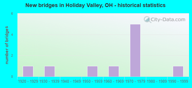
- New bridges - historical statistics
- 11920-1929
- 11930-1939
- 11950-1959
- 11960-1969
- 51970-1979
- 11990-1999

- Reconstructed bridges - Historical Statistics
- 21980-1989
- 21990-1999
- 02000-2009
- 22010-2019


- Bridge Condition - Deck
- 25.0%Very good
- 62.5%Good
- 12.5%Satisfactory

- Bridge Condition - Superstructure
- 37.5%Very good
- 50.0%Good
- 12.5%Satisfactory

- Bridge Condition - Substructure
- 25.0%Very good
- 62.5%Good
- 12.5%Satisfactory
Find on map >> Show street view
Structure Number: 1206567, Location: JCT. IR-675 AND IR-70 (Lat: 39.864981, Lng: -83.994011), Route carried "on" structure: Interstate 675, Year Built: 1975, Year Reconstructed: 2018, Status: Open, Structure Length: 9.42m (30.91ft), Average Daily Traffic: 20,000 (year 2019), Truck Traffic: 10%, Average Future Daily Traffic: 23,000 (year 2039), Design Load: HS 20+Mod, Features Intersected: IR 70
Minimum Vertical Clearance: 30+ m (98+ ft), Kilometerpoint: 2.010, Lanes on structure: 3, Lanes under structure: 8, Base Highway Network: Yes, Owner: State Highway Agency, Approaching Roadway Width: 11.6m (38.1ft), Skew: 1 degrees, Material/Design: Steel continuous, Design/Construction: Stringer/Multi-beam, Number Of Spans In Main Unit: 5, Length of Maximum Span: 25.9m (85.0ft), Curb-To-Curb Width: 16.0m (52.5ft), Out-to-Out Width: 17.1m (56.1ft)
Condition: Deck: Very good, Superstructure: Very good, Substructure: Very good, Operating Rating: 81.0 metric tons, Method Used To Determine Operating Rating: Load Factor (LF) rating reported by rating factor (RF) method using MS18 loading, Inventory Rating: 48.6 metric tons, Method Used To Determine Inventory Rating: Load Factor (LF) rating reported by rating factor (RF) method using MS18 loading, Structural Evaluation: Equal to present desirable criteria, Deck Geometry: Equal to present minimum criteria, Underclear: Meets minimum limits, Approach Roadway Alignment: Superior to present desirable criteria, Designated Inspection Frequency: Every 24 months, Inspection Date: January 2022, Deck Structure Type: Concrete Cast-file-Place, Wearing Surface/Protective System: Wearing Surface: Monolithic Concrete, Membrane: Epoxy, Deck Protection: Epoxy Coated Reinforcing
Find on map >> Show street view
Structure Number: 1206575, Location: JCT. IR-675 AND IR-70 (Lat: 39.865061, Lng: -83.993569), Route carried "on" structure: Interstate 675, Year Built: 1975, Year Reconstructed: 2017, Status: Open, Structure Length: 9.51m (31.20ft), Average Daily Traffic: 20,000 (year 2019), Truck Traffic: 10%, Average Future Daily Traffic: 23,000 (year 2039), Design Load: HS 20+Mod, Features Intersected: IR 70
Minimum Vertical Clearance: 30+ m (98+ ft), Kilometerpoint: 0.435, Lanes on structure: 2, Lanes under structure: 7, Base Highway Network: Yes, Owner: State Highway Agency, Approaching Roadway Width: 15.9m (52.2ft), Skew: 1 degrees, Material/Design: Steel continuous, Design/Construction: Stringer/Multi-beam, Number Of Spans In Main Unit: 5, Length of Maximum Span: 26.5m (86.9ft), Curb-To-Curb Width: 16.0m (52.5ft), Out-to-Out Width: 17.2m (56.4ft)
Condition: Deck: Very good, Superstructure: Very good, Substructure: Very good, Operating Rating: 90.7 metric tons, Method Used To Determine Operating Rating: Load Factor (LF) rating reported by rating factor (RF) method using MS18 loading, Inventory Rating: 55.1 metric tons, Method Used To Determine Inventory Rating: Load Factor (LF) rating reported by rating factor (RF) method using MS18 loading, Structural Evaluation: Equal to present desirable criteria, Deck Geometry: Superior to present desirable criteria, Underclear: Meets minimum limits, Approach Roadway Alignment: Superior to present desirable criteria, Designated Inspection Frequency: Every 24 months, Inspection Date: January 2022, Deck Structure Type: Concrete Cast-file-Place, Wearing Surface/Protective System: Wearing Surface: Monolithic Concrete, Membrane: Epoxy, Deck Protection: Epoxy Coated Reinforcing
Find on map >> Show street view
Structure Number: 1252003, Location: 1/2MI EAST ST RT 675 (Lat: 39.847911, Lng: -83.986239), Route carried "on" structure: County highway C0333, Year Built: 1952, Year Reconstructed: 1994, Status: Open, Structure Length: 3.20m (10.50ft), Average Daily Traffic: 10,558 (year 2015), Truck Traffic: 3%, Average Future Daily Traffic: 14,655 (year 2035), Design Load: H 15, Features Intersected: DAYTON RD & MUD RUN, Facility Carried by Structure: C-333
Minimum Vertical Clearance: 30+ m (98+ ft), Kilometerpoint: 0.290, Lanes on structure: 2, Owner: County Highway Agency, Approaching Roadway Width: 9.8m (32.2ft), Material/Design: Prestressed concrete continuous, Design/Construction: Stringer/Multi-beam, Number Of Spans In Main Unit: 3, Length of Maximum Span: 10.7m (35.1ft), Curb-To-Curb Width: 11.0m (36.1ft), Out-to-Out Width: 11.0m (36.1ft)
Condition: Deck: Good, Superstructure: Very good, Substructure: Good, Channel: Good, Operating Rating: 74.5 metric tons, Method Used To Determine Operating Rating: Load Factor (LF) rating reported by rating factor (RF) method using MS18 loading, Inventory Rating: 45.4 metric tons, Method Used To Determine Inventory Rating: Load Factor (LF) rating reported by rating factor (RF) method using MS18 loading, Structural Evaluation: Better than present minimum criteria, Deck Geometry: Meets minimum limits, Waterway Adequacy: Superior to present desirable criteria, Approach Roadway Alignment: Superior to present desirable criteria, Designated Inspection Frequency: Every 24 months, Inspection Date: October 2021, Deck Structure Type: Concrete Cast-file-Place, Wearing Surface/Protective System: Wearing Surface: Bituminous, Membrane: Preformed Fabric
Find on map >> Show street view
Structure Number: 125207, Location: .75 MI. E. I-675 (Lat: 39.849169, Lng: -83.983161), Route carried "on" structure: County highway C0333, Year Built: 1939, Year Reconstructed: 1990, Status: Posted for load, Structure Length: 23.38m (76.71ft), Average Daily Traffic: 10,558 (year 2015), Truck Traffic: 3%, Average Future Daily Traffic: 14,655 (year 2035), Design Load: H 15, Features Intersected: DAYTON RD O CONRAIL RR, Facility Carried by Structure: C-333
Minimum Vertical Clearance: 30+ m (98+ ft), Kilometerpoint: 0.547, Lanes on structure: 2, Owner: County Highway Agency, Approaching Roadway Width: 10.1m (33.1ft), Material/Design: Steel, Design/Construction: Girder and Floorbeam System, Number Of Spans In Main Unit: 12, Length of Maximum Span: 19.8m (65.0ft), Curb-To-Curb Width: 7.3m (24.0ft), Out-to-Out Width: 9.2m (30.2ft)
Condition: Deck: Good, Superstructure: Good, Substructure: Good, Operating Rating: 32.4 metric tons, Method Used To Determine Operating Rating: Load Factor (LF) rating reported by rating factor (RF) method using MS18 loading, Inventory Rating: 19.4 metric tons, Method Used To Determine Inventory Rating: Load Factor (LF) rating reported by rating factor (RF) method using MS18 loading, Structural Evaluation: Meets minimum limits, Deck Geometry: High priority of replacement, Underclear: Meets minimum limits, Approach Roadway Alignment: Better than present minimum criteria, Bridge Posting: Required (Relationship of Operating Rating to Maximum Legal Load: 20.0 - 29.9% below), Designated Inspection Frequency: Every 12 months, Critical Feature Inspection Frequency: Every 24 months, Inspection Date: October 2021, Critical Feature Inspection Date: September 2020, Deck Structure Type: Concrete Cast-file-Place, Wearing Surface/Protective System: Wearing Surface: Latex Concrete
Find on map >> Show street view
Structure Number: 1252305, Location: 1/2MI SO UNION RD (Lat: 39.870039, Lng: -83.993431), Route carried "on" structure: County highway C0335, Year Built: 1975, Status: Open, Structure Length: 2.77m (9.09ft), Average Daily Traffic: 9,442 (year 2015), Truck Traffic: 7%, Average Future Daily Traffic: 13,105 (year 2035), Features Intersected: SPANGLER RD & BR SMITH D, Facility Carried by Structure: C-335
Minimum Vertical Clearance: 30+ m (98+ ft), Kilometerpoint: 0.000, Lanes on structure: 2, Owner: County Highway Agency, Approaching Roadway Width: 32.3m (106.0ft), Skew: 23 degrees, Material/Design: Concrete continuous, Design/Construction: Slab, Number Of Spans In Main Unit: 3, Length of Maximum Span: 10.4m (34.1ft), Curb-To-Curb Width: 32.3m (106.0ft), Out-to-Out Width: 32.3m (106.0ft)
Condition: Deck: Satisfactory, Superstructure: Satisfactory, Substructure: Satisfactory, Channel: Good, Operating Rating: 58.3 metric tons, Method Used To Determine Operating Rating: Load Factor (LF) rating reported by rating factor (RF) method using MS18 loading, Inventory Rating: 35.6 metric tons, Method Used To Determine Inventory Rating: Load Factor (LF) rating reported by rating factor (RF) method using MS18 loading, Structural Evaluation: Equal to present minimum criteria, Deck Geometry: Superior to present desirable criteria, Waterway Adequacy: Better than present minimum criteria, Approach Roadway Alignment: Better than present minimum criteria, Designated Inspection Frequency: Every 12 months, Inspection Date: October 2021, Deck Structure Type: Concrete Cast-file-Place, Wearing Surface/Protective System: Wearing Surface: Bituminous, Membrane: Built-up
Find on map >> Show street view
Structure Number: 1252453, Location: 1/2 MILE N DAYTON SP RD. (Lat: 39.865731, Lng: -83.966411), Route carried "on" structure: County highway T0151, Year Built: 1929, Year Reconstructed: 1992, Status: Open, Structure Length: 1.04m (3.41ft), Average Daily Traffic: 910 (year 2015), Truck Traffic: 7%, Average Future Daily Traffic: 1,263 (year 2035), Design Load: HS 20, Features Intersected: SNIDER RD OV SMITH DITCH, Facility Carried by Structure: T 151
Minimum Vertical Clearance: 30+ m (98+ ft), Kilometerpoint: 0.483, Lanes on structure: 2, Owner: County Highway Agency, Approaching Roadway Width: 7.3m (24.0ft), Skew: 4 degrees, Material/Design: Prestressed concrete, Design/Construction: Box Beam or Girders - Multiple, Number Of Spans In Main Unit: 1, Length of Maximum Span: 10.4m (34.1ft), Curb-To-Curb Width: 7.3m (24.0ft), Out-to-Out Width: 7.9m (25.9ft)
Condition: Deck: Good, Superstructure: Good, Substructure: Good, Channel: Good, Operating Rating: 84.2 metric tons, Method Used To Determine Operating Rating: Load Factor (LF) rating reported by rating factor (RF) method using MS18 loading, Inventory Rating: 48.6 metric tons, Method Used To Determine Inventory Rating: Load Factor (LF) rating reported by rating factor (RF) method using MS18 loading, Structural Evaluation: Better than present minimum criteria, Deck Geometry: Meets minimum limits, Waterway Adequacy: Superior to present desirable criteria, Approach Roadway Alignment: Superior to present desirable criteria, Designated Inspection Frequency: Every 24 months, Inspection Date: October 2021, Deck Structure Type: Concrete Cast-file-Place, Wearing Surface/Protective System: Wearing Surface: Bituminous, Membrane: Preformed Fabric
Find on map >> Show street view
Structure Number: 1253751, Location: .5 MI.SO.DAYTON SPLFD.RD. (Lat: 39.857581, Lng: -83.965061), Route carried "on" structure: County highway T0001, Year Built: 1998, Status: Open, Structure Length: 3.02m (9.91ft), Average Daily Traffic: 261 (year 2015), Truck Traffic: 5%, Average Future Daily Traffic: 362 (year 2035), Design Load: HS 20, Features Intersected: HAHN AVE OV. MUD RUN, Facility Carried by Structure: HAHN AVE.
Minimum Vertical Clearance: 30+ m (98+ ft), Kilometerpoint: 5.150, Lanes on structure: 2, Owner: County Highway Agency, Approaching Roadway Width: 7.9m (25.9ft), Material/Design: Concrete, Design/Construction: Box Beam or Girders - Multiple, Number Of Spans In Main Unit: 3, Length of Maximum Span: 12.8m (42.0ft), Curb or Sidewalk Widths: Left: 1.2m (3.9ft), Right: 1.2m (3.9ft), Curb-To-Curb Width: 7.9m (25.9ft), Out-to-Out Width: 10.4m (34.1ft)
Condition: Deck: Good, Superstructure: Good, Substructure: Good, Channel: Good, Operating Rating: 42.1 metric tons, Method Used To Determine Operating Rating: Load Factor (LF) rating reported by rating factor (RF) method using MS18 loading, Inventory Rating: 25.9 metric tons, Method Used To Determine Inventory Rating: Load Factor (LF) rating reported by rating factor (RF) method using MS18 loading, Structural Evaluation: Equal to present minimum criteria, Deck Geometry: Somewhat better than minimum adequacy, Waterway Adequacy: Superior to present desirable criteria, Approach Roadway Alignment: Equal to present desirable criteria, Designated Inspection Frequency: Every 24 months, Inspection Date: October 2021, Deck Structure Type: Concrete Cast-file-Place, Wearing Surface/Protective System: Wearing Surface: Bituminous, Membrane: Built-up, Deck Protection: Other
Find on map >> Show street view
Structure Number: 1253808, Location: 1/2MI SO DAYTON SPLFD RD (Lat: 39.854689, Lng: -83.967081), Route carried "on" structure: County highway T1479, Year Built: 1968, Year Reconstructed: 2002, Status: Open, Structure Length: 2.87m (9.42ft), Average Daily Traffic: 1,949 (year 2015), Truck Traffic: 5%, Average Future Daily Traffic: 2,705 (year 2035), Design Load: H 20, Features Intersected: WESTCOTT AVE O MUD RUN, Facility Carried by Structure: T-1479
Minimum Vertical Clearance: 30+ m (98+ ft), Kilometerpoint: 0.515, Lanes on structure: 2, Owner: County Highway Agency, Approaching Roadway Width: 8.2m (26.9ft), Material/Design: Prestressed concrete, Design/Construction: Box Beam or Girders - Multiple, Number Of Spans In Main Unit: 2, Length of Maximum Span: 14.0m (45.9ft), Curb or Sidewalk Widths: Left: 1.4m (4.6ft), Right: 1.4m (4.6ft), Curb-To-Curb Width: 8.2m (26.9ft), Out-to-Out Width: 11.0m (36.1ft)
Condition: Deck: Good, Superstructure: Good, Substructure: Good, Channel: Good, Operating Rating: 64.8 metric tons, Method Used To Determine Operating Rating: Load Factor (LF) rating reported by rating factor (RF) method using MS18 loading, Inventory Rating: 38.9 metric tons, Method Used To Determine Inventory Rating: Load Factor (LF) rating reported by rating factor (RF) method using MS18 loading, Structural Evaluation: Better than present minimum criteria, Deck Geometry: Meets minimum limits, Waterway Adequacy: Better than present minimum criteria, Approach Roadway Alignment: Better than present minimum criteria, Designated Inspection Frequency: Every 24 months, Inspection Date: October 2021, Deck Structure Type: Concrete Cast-file-Place, Wearing Surface/Protective System: Wearing Surface: Bituminous, Membrane: Preformed Fabric
Find on map >> Show street view
Structure Number: 1206567, Location: JCT. IR-675 AND IR-70 (Lat: 39.864981, Lng: -83.994011), Route carried "under" structure: Interstate 70, Year Built: 1975, Structure Length: 0. m, Average Daily Traffic: 64,894 (year 2016), Truck Traffic: 26%, Features Intersected: IR-675, Facility Carried by Structure: IR-675
Minimum Vertical Clearance: 5.09m (16.70ft), Kilometerpoint: 4.989, Lanes on structure: 3, Lanes under structure: 8, Material/Design: Steel continuous, Design/Construction: Stringer/Multi-beam, Length of Maximum Span: 25.9m (85.0ft)
Find on map >> Show street view
Structure Number: 1206575, Location: JCT. IR-675 AND IR-70 (Lat: 39.865061, Lng: -83.993569), Route carried "under" structure: Interstate 70, Year Built: 1975, Structure Length: 0. m, Average Daily Traffic: 80,685 (year 2016), Truck Traffic: 23%, Features Intersected: IR-675, Facility Carried by Structure: IR-675
Minimum Vertical Clearance: 5.06m (16.60ft), Kilometerpoint: 5.021, Lanes on structure: 2, Lanes under structure: 7, Material/Design: Steel continuous, Design/Construction: Stringer/Multi-beam, Length of Maximum Span: 26.5m (86.9ft)