Bridge Statistics for Holiday Pocono, Pennsylvania (PA)
Condition, Traffic, Stress, Structural Evaluation, Project Costs
- National Bridge Inventory (NBI) Statistics
- 14Number of bridges
- 112ft / 33.5mTotal length
- $1,825,000Total costs
- 124,733Total average daily traffic
- 27,696Total average daily truck traffic
- National Bridge Inventory (NBI) Registered Bridges for Holiday Pocono
- No street view available for this location
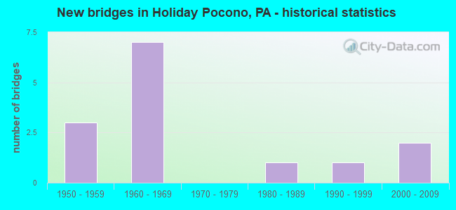
- New bridges - historical statistics
- 31950-1959
- 71960-1969
- 11980-1989
- 11990-1999
- 22000-2009

- Reconstructed bridges - Historical Statistics
- 11970-1979
- 11980-1989


- Bridge Condition - Deck
- 42.9%Good
- 57.1%Satisfactory

- Bridge Condition - Superstructure
- 42.9%Very good
- 28.6%Good
- 28.6%Satisfactory

- Bridge Condition - Substructure
- 42.9%Good
- 42.9%Satisfactory
- 14.3%Fair

- Bridge Condition - Channel
- 60.0%Good
- 40.0%Fair
Find on map >> Show street view
Structure Number: 898, Location: 1.5 MI.E.OF TURNPIKE (Lat: 41.077331, Lng: -75.668983), Route carried "on" structure: Interstate 80, Year Built: 1964, Status: Open, Structure Length: 0.64m (2.10ft), Average Daily Traffic: 9,981 (year 2021), Truck Traffic: 27%, Average Future Daily Traffic: 14,093 (year 2032), Design Load: HS 20+Mod, Features Intersected: BLACK CREEK
Minimum Vertical Clearance: 30+ m (98+ ft), Kilometerpoint: 9.291, Lanes on structure: 2, Base Highway Network: Yes, Owner: State Highway Agency, Approaching Roadway Width: 12.5m (41.0ft), Skew: 11 degrees, Material/Design: Concrete, Design/Construction: Culvert, Number Of Spans In Main Unit: 1, Length of Maximum Span: 6.4m (21.0ft)
Condition: Channel: Fair, Culverts: Satisfactory, Operating Rating: 48.1 metric tons, Method Used To Determine Operating Rating: Load Factor (LF), Inventory Rating: 28.1 metric tons, Method Used To Determine Inventory Rating: Load Factor (LF), Structural Evaluation: Equal to present minimum criteria, Waterway Adequacy: Equal to present minimum criteria, Approach Roadway Alignment: Equal to present desirable criteria, Length Of Structure Improvement: 1.30m (4.27ft), Designated Inspection Frequency: Every 24 months, Inspection Date: September 2021, Bridge Improvement Cost: $7,000, Roadway Improvement Cost: $20,000, Total Project Cost: $92,000
Find on map >> Show street view
Structure Number: 8982, Location: MOSEYWOOD RD. OVER I-80 (Lat: 41.082500, Lng: -75.636472), Route carried "on" structure: ServiceState highway , Year Built: 1964, Status: Open, Structure Length: 5.97m (19.59ft), Average Daily Traffic: 1,159 (year 2021), Truck Traffic: 3%, Average Future Daily Traffic: 2,311 (year 2032), Design Load: HS 20, Features Intersected: I-80, Facility Carried by Structure: SR1003 MOSEYWOODRD
Minimum Vertical Clearance: 30+ m (98+ ft), Kilometerpoint: 4.068, Lanes on structure: 2, Lanes under structure: 8, Owner: State Highway Agency, Approaching Roadway Width: 9.8m (32.2ft), Material/Design: Prestressed concrete, Design/Construction: Box Beam or Girders - Single/Spread, Number Of Spans In Main Unit: 4, Length of Maximum Span: 19.5m (64.0ft), Curb or Sidewalk Widths: Left: 0.5m (1.6ft), Right: 0.5m (1.6ft), Curb-To-Curb Width: 8.5m (27.9ft), Out-to-Out Width: 10.2m (33.5ft)
Condition: Deck: Satisfactory, Superstructure: Satisfactory, Substructure: Satisfactory, Operating Rating: 52.6 metric tons, Method Used To Determine Operating Rating: Load Factor (LF), Inventory Rating: 25.4 metric tons, Method Used To Determine Inventory Rating: Load Factor (LF), Structural Evaluation: Equal to present minimum criteria, Deck Geometry: Somewhat better than minimum adequacy, Underclear: High priority of corrective action, Approach Roadway Alignment: Better than present minimum criteria, Length Of Structure Improvement: 7.00m (22.97ft), Designated Inspection Frequency: Every 24 months, Inspection Date: September 2021, Bridge Improvement Cost: $62,000, Roadway Improvement Cost: $183,000, Total Project Cost: $839,000, Deck Structure Type: Concrete Cast-file-Place, Wearing Surface/Protective System: Wearing Surface: Latex Concrete
Find on map >> Show street view
Structure Number: 9167, Location: 6 MI S OF POCONO INTERCH. (Lat: 41.035597, Lng: -75.659114), Route carried "on" structure: Interstate 476, Year Built: 1956, Year Reconstructed: 1989, Status: Open, Structure Length: 2.44m (8.01ft), Average Daily Traffic: 22,198 (year 2001), Truck Traffic: 22%, Average Future Daily Traffic: 30,443 (year 2030), Design Load: HS 20, Features Intersected: FOX TRAIL RD
Minimum Vertical Clearance: 30+ m (98+ ft), Kilometerpoint: 0.000, Lanes on structure: 4, Lanes under structure: 2, Base Highway Network: Yes, Toll: On toll road, Owner: State Toll Authority, Approaching Roadway Width: 23.2m (76.1ft), Skew: 30 degrees, Material/Design: Prestressed concrete, Design/Construction: Box Beam or Girders - Single/Spread, Number Of Spans In Main Unit: 1, Length of Maximum Span: 23.8m (78.1ft), Curb or Sidewalk Widths: Left: 0.2m (0.7ft), Right: 0.2m (0.7ft), Curb-To-Curb Width: 22.4m (73.5ft), Out-to-Out Width: 24.0m (78.7ft)
Condition: Deck: Satisfactory, Superstructure: Good, Substructure: Satisfactory, Operating Rating: 74.4 metric tons, Method Used To Determine Operating Rating: Load Factor (LF), Inventory Rating: 41.7 metric tons, Method Used To Determine Inventory Rating: Load Factor (LF), Structural Evaluation: Equal to present minimum criteria, Deck Geometry: Superior to present desirable criteria, Underclear: High priority of corrective action, Approach Roadway Alignment: Equal to present desirable criteria, Length Of Structure Improvement: 3.20m (10.50ft), Designated Inspection Frequency: Every 24 months, Inspection Date: June 2021, Bridge Improvement Cost: $66,000, Roadway Improvement Cost: $195,000, Total Project Cost: $894,000, Deck Structure Type: Concrete Cast-file-Place, Wearing Surface/Protective System: Wearing Surface: Latex Concrete
Find on map >> Show street view
Structure Number: 26757, Location: PA 115 0VER I-80 (Lat: 41.076836, Lng: -75.577908), Route carried "on" structure: State highway 115, Year Built: 1965, Year Reconstructed: 1977, Status: Open, Structure Length: 7.96m (26.12ft), Average Daily Traffic: 9,370 (year 2021), Truck Traffic: 7%, Average Future Daily Traffic: 14,194 (year 2032), Design Load: HS 20, Features Intersected: SR 80(LR 1009)
Minimum Vertical Clearance: 30+ m (98+ ft), Kilometerpoint: 24.359, Lanes on structure: 4, Lanes under structure: 12, Base Highway Network: Yes, Owner: State Highway Agency, Approaching Roadway Width: 21.9m (71.9ft), Skew: 25 degrees, Material/Design: Steel continuous, Design/Construction: Stringer/Multi-beam, Number Of Spans In Main Unit: 2, Length of Maximum Span: 39.6m (129.9ft), Curb or Sidewalk Widths: Left: 0.5m (1.6ft), Right: 0.5m (1.6ft), Curb-To-Curb Width: 21.9m (71.9ft), Out-to-Out Width: 23.6m (77.4ft)
Condition: Deck: Satisfactory, Superstructure: Satisfactory, Substructure: Fair, Operating Rating: 40.8 metric tons, Method Used To Determine Operating Rating: Load Factor (LF), Inventory Rating: 24.5 metric tons, Method Used To Determine Inventory Rating: Load Factor (LF), Structural Evaluation: Somewhat better than minimum adequacy, Deck Geometry: Superior to present desirable criteria, Underclear: High priority of corrective action, Approach Roadway Alignment: Equal to present desirable criteria, Length Of Structure Improvement: 8.90m (29.20ft), Designated Inspection Frequency: Every 24 months, Inspection Date: December 2020, Deck Structure Type: Concrete Cast-file-Place, Wearing Surface/Protective System: Wearing Surface: Latex Concrete
Find on map >> Show street view
Structure Number: 26759, Location: 0.8 MI.S.BLAKESLEE CORNER (Lat: 41.082706, Lng: -75.583639), Route carried "on" structure: State highway 115, Year Built: 1985, Status: Open, Structure Length: 3.63m (11.91ft), Average Daily Traffic: 9,369 (year 2021), Truck Traffic: 7%, Average Future Daily Traffic: 14,192 (year 2032), Design Load: HS 20+Mod, Features Intersected: TOBYHANNA CREEK
Minimum Vertical Clearance: 30+ m (98+ ft), Kilometerpoint: 25.053, Lanes on structure: 2, Base Highway Network: Yes, Owner: State Highway Agency, Approaching Roadway Width: 12.2m (40.0ft), Material/Design: Prestressed concrete, Design/Construction: Box Beam or Girders - Multiple, Number Of Spans In Main Unit: 2, Length of Maximum Span: 17.7m (58.1ft), Curb-To-Curb Width: 12.2m (40.0ft), Out-to-Out Width: 13.3m (43.6ft)
Condition: Deck: Satisfactory, Superstructure: Good, Substructure: Satisfactory, Channel: Fair, Operating Rating: 96.2 metric tons, Method Used To Determine Operating Rating: Load Factor (LF), Inventory Rating: 46.3 metric tons, Method Used To Determine Inventory Rating: Load Factor (LF), Structural Evaluation: Equal to present minimum criteria, Deck Geometry: Somewhat better than minimum adequacy, Waterway Adequacy: Equal to present desirable criteria, Approach Roadway Alignment: Equal to present desirable criteria, Length Of Structure Improvement: 4.50m (14.76ft), Designated Inspection Frequency: Every 48 months, Inspection Date: November 2019, Deck Structure Type: Concrete Cast-file-Place, Wearing Surface/Protective System: Wearing Surface: Monolithic Concrete, Deck Protection: Epoxy Coated Reinforcing
Find on map >> Show street view
Structure Number: 26902, Location: CARBON CO./MONROE CO.LINE (Lat: 41.084619, Lng: -75.605472), Route carried "on" structure: State highway 940, Year Built: 1993, Status: Open, Structure Length: 3.87m (12.70ft), Average Daily Traffic: 2,212 (year 2022), Truck Traffic: 9%, Average Future Daily Traffic: 3,811 (year 2032), Design Load: HS 25 or greater, Features Intersected: TOBYHANNA CREEK
Minimum Vertical Clearance: 30+ m (98+ ft), Kilometerpoint: 0.000, Lanes on structure: 2, Base Highway Network: Yes, Owner: State Highway Agency, Approaching Roadway Width: 13.1m (43.0ft), Material/Design: Prestressed concrete, Design/Construction: Stringer/Multi-beam, Number Of Spans In Main Unit: 1, Length of Maximum Span: 38.4m (126.0ft), Curb or Sidewalk Widths: Left: 0.2m (0.7ft), Right: 0.2m (0.7ft), Curb-To-Curb Width: 13.1m (43.0ft), Out-to-Out Width: 14.2m (46.6ft)
Condition: Deck: Good, Superstructure: Very good, Substructure: Good, Channel: Good, Inventory Rating: 48.1 metric tons, Method Used To Determine Inventory Rating: Load Factor (LF), Structural Evaluation: Better than present minimum criteria, Deck Geometry: Equal to present minimum criteria, Waterway Adequacy: Superior to present desirable criteria, Approach Roadway Alignment: Equal to present desirable criteria, Length Of Structure Improvement: 4.70m (15.42ft), Designated Inspection Frequency: Every 48 months, Inspection Date: November 2019, Deck Structure Type: Concrete Cast-file-Place, Wearing Surface/Protective System: Wearing Surface: Monolithic Concrete, Deck Protection: Epoxy Coated Reinforcing
Find on map >> Show street view
Structure Number: 44964, Location: AT CARBON CO. LINE (Lat: 41.077236, Lng: -75.589292), Route carried "on" structure: Interstate 80, Year Built: 2006, Status: Open, Structure Length: 4.54m (14.90ft), Average Daily Traffic: 10,848 (year 2021), Truck Traffic: 32%, Average Future Daily Traffic: 16,165 (year 2032), Design Load: HL 93, Features Intersected: TUNKHANNOCK CREEK
Minimum Vertical Clearance: 30+ m (98+ ft), Kilometerpoint: 0.000, Lanes on structure: 2, Base Highway Network: Yes, Owner: State Highway Agency, Approaching Roadway Width: 12.8m (42.0ft), Skew: 3 degrees, Material/Design: Prestressed concrete, Design/Construction: Stringer/Multi-beam, Number Of Spans In Main Unit: 1, Length of Maximum Span: 43.6m (143.0ft), Curb-To-Curb Width: 12.8m (42.0ft), Out-to-Out Width: 13.8m (45.3ft)
Condition: Deck: Good, Superstructure: Very good, Substructure: Good, Channel: Good, Operating Rating: 76.2 metric tons, Method Used To Determine Operating Rating: Load Factor (LF), Inventory Rating: 28.1 metric tons, Method Used To Determine Inventory Rating: Load Factor (LF), Structural Evaluation: Better than present minimum criteria, Deck Geometry: Equal to present desirable criteria, Waterway Adequacy: Superior to present desirable criteria, Approach Roadway Alignment: Equal to present desirable criteria, Designated Inspection Frequency: Every 24 months, Inspection Date: August 2020, Deck Structure Type: Concrete Cast-file-Place, Wearing Surface/Protective System: Wearing Surface: Monolithic Concrete, Deck Protection: Epoxy Coated Reinforcing
Find on map >> Show street view
Structure Number: 44995, Location: AT CARBON CTY. LINE (Lat: 41.076969, Lng: -75.588758), Route carried "on" structure: Interstate 80, Year Built: 2006, Status: Open, Structure Length: 4.45m (14.60ft), Average Daily Traffic: 9,981 (year 2021), Truck Traffic: 27%, Average Future Daily Traffic: 15,471 (year 2032), Design Load: HL 93, Features Intersected: TUNKHANNOCK CREEK
Minimum Vertical Clearance: 30+ m (98+ ft), Kilometerpoint: 0.000, Lanes on structure: 2, Base Highway Network: Yes, Owner: State Highway Agency, Approaching Roadway Width: 12.8m (42.0ft), Skew: 3 degrees, Material/Design: Prestressed concrete, Design/Construction: Stringer/Multi-beam, Number Of Spans In Main Unit: 1, Length of Maximum Span: 43.6m (143.0ft), Curb-To-Curb Width: 12.8m (42.0ft), Out-to-Out Width: 13.8m (45.3ft)
Condition: Deck: Good, Superstructure: Very good, Substructure: Good, Channel: Good, Operating Rating: 76.2 metric tons, Method Used To Determine Operating Rating: Load Factor (LF), Inventory Rating: 28.1 metric tons, Method Used To Determine Inventory Rating: Load Factor (LF), Structural Evaluation: Better than present minimum criteria, Deck Geometry: Equal to present desirable criteria, Waterway Adequacy: Superior to present desirable criteria, Approach Roadway Alignment: Equal to present desirable criteria, Designated Inspection Frequency: Every 24 months, Inspection Date: August 2020, Deck Structure Type: Concrete Cast-file-Place, Wearing Surface/Protective System: Wearing Surface: Monolithic Concrete, Deck Protection: Epoxy Coated Reinforcing
Find on map >> Show street view
Structure Number: 8982, Location: MOSEYWOOD RD. OVER I-80 (Lat: 41.082500, Lng: -75.636472), Route carried "under" structure: Interstate 80, Year Built: 1964, Structure Length: 0. m, Average Daily Traffic: 9,981 (year 2021), Truck Traffic: 27%, Features Intersected: I-80, Facility Carried by Structure: SR1003 MOSEYWOODRD
Minimum Vertical Clearance: 5.18m (16.99ft), Kilometerpoint: 11.705, Lanes on structure: 2, Lanes under structure: 4, Material/Design: Prestressed concrete, Design/Construction: Box Beam or Girders - Single/Spread, Length of Maximum Span: 19.5m (64.0ft)
Find on map >> Show street view
Structure Number: 8982, Location: MOSEYWOOD RD. OVER I-80 (Lat: 41.082500, Lng: -75.636472), Route carried "under" structure: Interstate 80, Year Built: 1964, Structure Length: 0. m, Average Daily Traffic: 10,848 (year 2021), Truck Traffic: 32%, Features Intersected: I-80, Facility Carried by Structure: SR1003 MOSEYWOODRD
Minimum Vertical Clearance: 5.49m (18.01ft), Kilometerpoint: 11.695, Lanes on structure: 2, Lanes under structure: 4, Material/Design: Prestressed concrete, Design/Construction: Box Beam or Girders - Single/Spread, Length of Maximum Span: 19.5m (64.0ft)
Find on map >> Show street view
Structure Number: 9167, Location: 6 MI S OF POCONO INTERCH. (Lat: 41.035597, Lng: -75.659114), Route carried "under" structure: City street , Year Built: 1956, Structure Length: 0. m, Average Daily Traffic: 200 (year 1992), Features Intersected: FOX TRAIL RD, Facility Carried by Structure: PA TPK (I-476)
Minimum Vertical Clearance: 4.09m (13.42ft), Kilometerpoint: 0.000, Lanes on structure: 4, Lanes under structure: 2, Toll: On toll road, Material/Design: Prestressed concrete, Design/Construction: Box Beam or Girders - Single/Spread, Length of Maximum Span: 23.8m (78.1ft)
Find on map >> Show street view
Structure Number: 9168, Location: 4 MI S OF POCONO INTERCH. (Lat: 41.046061, Lng: -75.670136), Route carried "under" structure: City street , Year Built: 1956, Structure Length: 0. m, Average Daily Traffic: 200 (year 2008), Truck Traffic: 1%, Features Intersected: PARK RD, Facility Carried by Structure: PA TPK (I-476)
Minimum Vertical Clearance: 4.50m (14.76ft), Kilometerpoint: 0.000, Lanes on structure: 4, Lanes under structure: 2, Toll: On toll road, Material/Design: Concrete, Design/Construction: Tee Beam, Length of Maximum Span: 9.8m (32.2ft)
Find on map >> Show street view
Structure Number: 26757, Location: PA 115 0VER I-80 (Lat: 41.076836, Lng: -75.577908), Route carried "under" structure: Interstate 80, Year Built: 1965, Structure Length: 0. m, Average Daily Traffic: 14,052 (year 2021), Truck Traffic: 22%, Features Intersected: SR 80(LR 1009), Facility Carried by Structure: PA 115 (LR 45049)
Minimum Vertical Clearance: 5.03m (16.50ft), Kilometerpoint: 0.985, Lanes on structure: 4, Lanes under structure: 6, Material/Design: Steel continuous, Design/Construction: Stringer/Multi-beam, Length of Maximum Span: 39.6m (129.9ft)
Find on map >> Show street view
Structure Number: 26757, Location: PA 115 0VER I-80 (Lat: 41.076836, Lng: -75.577908), Route carried "under" structure: Interstate 80, Year Built: 1965, Structure Length: 0. m, Average Daily Traffic: 14,334 (year 2021), Truck Traffic: 22%, Features Intersected: SR 80(LR 1009), Facility Carried by Structure: PA 115 (LR 45049)
Minimum Vertical Clearance: 4.91m (16.11ft), Kilometerpoint: 0.998, Lanes on structure: 4, Lanes under structure: 6, Material/Design: Steel continuous, Design/Construction: Stringer/Multi-beam, Length of Maximum Span: 39.6m (129.9ft)