Bridge Statistics for Holbrook, New York (NY)
Condition, Traffic, Stress, Structural Evaluation, Project Costs
- National Bridge Inventory (NBI) Statistics
- 11Number of bridges
- 128ft / 38.7mTotal length
- $45,413,000Total costs
- 320,534Total average daily traffic
- 6,268Total average daily truck traffic
- National Bridge Inventory (NBI) Registered Bridges for Holbrook
- No street view available for this location
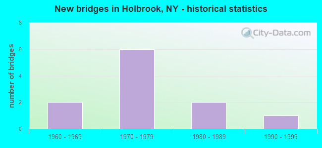
- New bridges - historical statistics
- 21960-1969
- 61970-1979
- 21980-1989
- 11990-1999
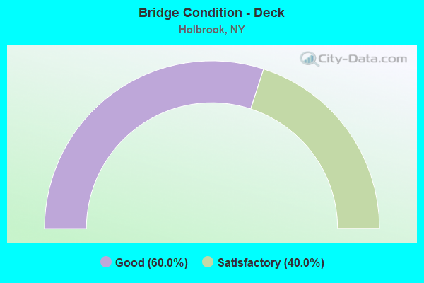
- Bridge Condition - Deck
- 60.0%Good
- 40.0%Satisfactory
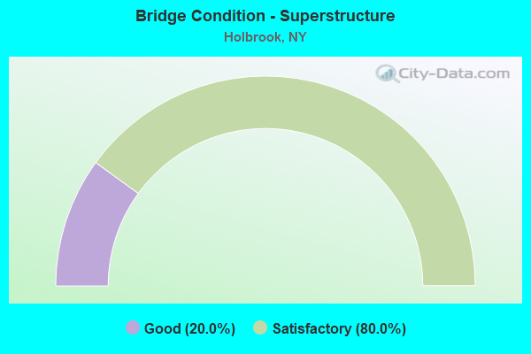
- Bridge Condition - Superstructure
- 20.0%Good
- 80.0%Satisfactory
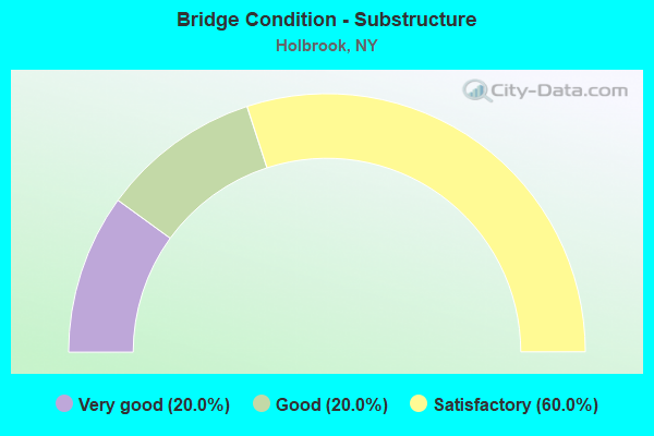
- Bridge Condition - Substructure
- 20.0%Very good
- 20.0%Good
- 60.0%Satisfactory
Find on map >> Show street view
Structure Number: 1049519, Location: AT EXIT 61 0F I495 (Lat: 40.815581, Lng: -73.084386), Route carried "on" structure: County highway , Year Built: 1967, Year Reconstructed: 2017, Status: Open, Structure Length: 8.81m (28.90ft), Average Daily Traffic: 20,091 (year 2018), Truck Traffic: 3%, Average Future Daily Traffic: 24,406 (year 2040), Design Load: H 20, Features Intersected: 495I495I07031192, RTE I4, Facility Carried by Structure: PATCHOGUE-HOLBROO
Minimum Vertical Clearance: 30+ m (98+ ft), Kilometerpoint: 8.705, Lanes on structure: 5, Lanes under structure: 8, Owner: State Highway Agency, Approaching Roadway Width: 21.3m (69.9ft), Skew: 3 degrees, Material/Design: Steel, Design/Construction: Stringer/Multi-beam, Number Of Spans In Main Unit: 4, Length of Maximum Span: 29.2m (95.8ft), Curb or Sidewalk Widths: Left: 1.5m (4.9ft), Right: 1.5m (4.9ft), Curb-To-Curb Width: 21.3m (69.9ft), Out-to-Out Width: 25.4m (83.3ft)
Condition: Deck: Good, Superstructure: Satisfactory, Substructure: Very good, Operating Rating: 30.5 metric tons, Method Used To Determine Operating Rating: Load and Resistance Factor Rating (LRFR) rating reported by rating factor(RF) method using HL-93 loadings, Inventory Rating: 23.3 metric tons, Method Used To Determine Inventory Rating: Load and Resistance Factor Rating (LRFR) rating reported by rating factor(RF) method using HL-93 loadings, Structural Evaluation: Somewhat better than minimum adequacy, Deck Geometry: Somewhat better than minimum adequacy, Underclear: High priority of corrective action, Approach Roadway Alignment: Better than present minimum criteria, Length Of Structure Improvement: 8.80m (28.87ft), Designated Inspection Frequency: Every 24 months, Inspection Date: September 2021, Bridge Improvement Cost: $8,475,000, Roadway Improvement Cost: $4,963,000, Total Project Cost: $13,438,000 ( Estimate for 2021), Deck Structure Type: Concrete Cast-file-Place, Wearing Surface/Protective System: Wearing Surface: Integral Concrete
Find on map >> Show street view
Structure Number: 107322, Location: AT INTERS.RTS 27 & 454 (Lat: 40.769353, Lng: -73.057956), Route carried "on" structure: State highway 454, Year Built: 1989, Status: Open, Structure Length: 11.77m (38.62ft), Average Daily Traffic: 14,686 (year 2020), Truck Traffic: 10%, Average Future Daily Traffic: 16,944 (year 2040), Design Load: HS 20, Features Intersected: 27 27 07051206, WB Serv
Minimum Vertical Clearance: 30+ m (98+ ft), Kilometerpoint: 21.931, Lanes on structure: 2, Lanes under structure: 8, Base Highway Network: Yes, Owner: State Highway Agency, Approaching Roadway Width: 11.9m (39.0ft), Skew: 5 degrees, Material/Design: Steel continuous, Design/Construction: Stringer/Multi-beam, Number Of Spans In Main Unit: 3, Length of Maximum Span: 43.5m (142.7ft), Curb-To-Curb Width: 11.9m (39.0ft), Out-to-Out Width: 13.1m (43.0ft)
Condition: Deck: Good, Superstructure: Good, Substructure: Good, Operating Rating: 71.7 metric tons, Method Used To Determine Operating Rating: Load Factor (LF), Inventory Rating: 39.9 metric tons, Method Used To Determine Inventory Rating: Load Factor (LF), Structural Evaluation: Better than present minimum criteria, Deck Geometry: Better than present minimum criteria, Underclear: Somewhat better than minimum adequacy, Approach Roadway Alignment: Equal to present desirable criteria, Length Of Structure Improvement: 11.76m (38.58ft), Designated Inspection Frequency: Every 24 months, Inspection Date: November 2021, Bridge Improvement Cost: $6,630,000, Roadway Improvement Cost: $3,882,000, Total Project Cost: $10,512,000 ( Estimate for 2021), Deck Structure Type: Concrete Cast-file-Place, Wearing Surface/Protective System: Wearing Surface: Integral Concrete, Deck Protection: Epoxy Coated Reinforcing
Find on map >> Show street view
Structure Number: 33644, Location: 1.9 MI WEST OF HOLTSVILLE (Lat: 40.810692, Lng: -73.076347), Route carried "on" structure: County highway , Year Built: 1973, Status: Open, Structure Length: 7.25m (23.79ft), Average Daily Traffic: 19,299 (year 2018), Truck Traffic: 3%, Average Future Daily Traffic: 23,444 (year 2040), Design Load: HS 20, Features Intersected: RAILROAD AVE, LIRR MAIN, Facility Carried by Structure: HOLBROOK RD
Minimum Vertical Clearance: 30+ m (98+ ft), Kilometerpoint: 7.788, Lanes on structure: 6, Lanes under structure: 2, Owner: County Highway Agency, Approaching Roadway Width: 23.8m (78.1ft), Skew: 23 degrees, Material/Design: Steel, Design/Construction: Stringer/Multi-beam, Number Of Spans In Main Unit: 4, Length of Maximum Span: 19.5m (64.0ft), Curb or Sidewalk Widths: Left: 1.2m (3.9ft), Right: 1.2m (3.9ft), Curb-To-Curb Width: 23.8m (78.1ft), Out-to-Out Width: 26.8m (87.9ft)
Condition: Deck: Satisfactory, Superstructure: Satisfactory, Substructure: Satisfactory, Operating Rating: 58.3 metric tons, Method Used To Determine Operating Rating: Load and Resistance Factor Rating (LRFR) rating reported by rating factor(RF) method using HL-93 loadings, Inventory Rating: 45.0 metric tons, Method Used To Determine Inventory Rating: Load and Resistance Factor Rating (LRFR) rating reported by rating factor(RF) method using HL-93 loadings, Structural Evaluation: Equal to present minimum criteria, Deck Geometry: Somewhat better than minimum adequacy, Underclear: Somewhat better than minimum adequacy, Approach Roadway Alignment: Equal to present desirable criteria, Length Of Structure Improvement: 7.25m (23.79ft), Designated Inspection Frequency: Every 24 months, Inspection Date: August 2020, Bridge Improvement Cost: $7,452,000, Roadway Improvement Cost: $4,364,000, Total Project Cost: $11,816,000 ( Estimate for 2021), Deck Structure Type: Concrete Cast-file-Place, Wearing Surface/Protective System: Wearing Surface: Integral Concrete
Find on map >> Show street view
Structure Number: 3364451, Location: 2 MI S OF HOLTSVILLE (Lat: 40.790869, Lng: -73.051678), Route carried "on" structure: County highway , Year Built: 1973, Status: Open, Structure Length: 5.43m (17.81ft), Average Daily Traffic: 30,179 (year 2020), Truck Traffic: 6%, Average Future Daily Traffic: 34,820 (year 2040), Design Load: HS 20, Features Intersected: HOLBROOK ROAD, Facility Carried by Structure: NICOLLS ROAD SB
Minimum Vertical Clearance: 30+ m (98+ ft), Kilometerpoint: 4.505, Lanes on structure: 2, Lanes under structure: 4, Owner: County Highway Agency, Approaching Roadway Width: 8.8m (28.9ft), Skew: 3 degrees, Material/Design: Steel, Design/Construction: Stringer/Multi-beam, Number Of Spans In Main Unit: 2, Length of Maximum Span: 26.5m (86.9ft), Curb or Sidewalk Widths: Left: 0.3m (1.0ft), Right: 0.3m (1.0ft), Curb-To-Curb Width: 12.2m (40.0ft), Out-to-Out Width: 13.4m (44.0ft)
Condition: Deck: Satisfactory, Superstructure: Satisfactory, Substructure: Satisfactory, Operating Rating: 76.2 metric tons, Method Used To Determine Operating Rating: Load Factor (LF), Inventory Rating: 45.4 metric tons, Method Used To Determine Inventory Rating: Load Factor (LF), Structural Evaluation: Equal to present minimum criteria, Deck Geometry: Better than present minimum criteria, Underclear: Meets minimum limits, Approach Roadway Alignment: Equal to present desirable criteria, Length Of Structure Improvement: 5.42m (17.78ft), Designated Inspection Frequency: Every 24 months, Inspection Date: Febuary 2020, Bridge Improvement Cost: $3,060,000, Roadway Improvement Cost: $1,792,000, Total Project Cost: $4,851,000 ( Estimate for 2021), Deck Structure Type: Concrete Cast-file-Place, Wearing Surface/Protective System: Wearing Surface: Integral Concrete
Find on map >> Show street view
Structure Number: 3364452, Location: 2 MI S OF HOLTSVILLE (Lat: 40.790856, Lng: -73.051400), Route carried "on" structure: County highway , Year Built: 1973, Status: Open, Structure Length: 5.43m (17.81ft), Average Daily Traffic: 30,179 (year 2020), Truck Traffic: 6%, Average Future Daily Traffic: 34,820 (year 2040), Design Load: HS 20, Features Intersected: HOLBROOK ROAD, Facility Carried by Structure: NICOLLS ROAD NB
Minimum Vertical Clearance: 30+ m (98+ ft), Kilometerpoint: 4.505, Lanes on structure: 2, Lanes under structure: 4, Owner: County Highway Agency, Approaching Roadway Width: 9.4m (30.8ft), Skew: 3 degrees, Material/Design: Steel, Design/Construction: Stringer/Multi-beam, Number Of Spans In Main Unit: 2, Length of Maximum Span: 26.5m (86.9ft), Curb or Sidewalk Widths: Left: 0.3m (1.0ft), Right: 0.3m (1.0ft), Curb-To-Curb Width: 12.2m (40.0ft), Out-to-Out Width: 13.4m (44.0ft)
Condition: Deck: Good, Superstructure: Satisfactory, Substructure: Satisfactory, Operating Rating: 76.2 metric tons, Method Used To Determine Operating Rating: Load Factor (LF), Inventory Rating: 45.4 metric tons, Method Used To Determine Inventory Rating: Load Factor (LF), Structural Evaluation: Equal to present minimum criteria, Deck Geometry: Better than present minimum criteria, Underclear: Somewhat better than minimum adequacy, Approach Roadway Alignment: Equal to present desirable criteria, Length Of Structure Improvement: 5.42m (17.78ft), Designated Inspection Frequency: Every 24 months, Inspection Date: Febuary 2020, Bridge Improvement Cost: $3,025,000, Roadway Improvement Cost: $1,771,000, Total Project Cost: $4,796,000 ( Estimate for 2021), Deck Structure Type: Concrete Cast-file-Place, Wearing Surface/Protective System: Wearing Surface: Integral Concrete
Find on map >> Show street view
Structure Number: 1049519, Location: AT EXIT 61 0F I495 (Lat: 40.815581, Lng: -73.084386), Route carried "under" structure: Interstate 495, Year Built: 1967, Structure Length: 0. m, Average Daily Traffic: 70,000 (year 1972), Features Intersected: 495I495I07031192, RTE I4, Facility Carried by Structure: PATCHOGUE-HOLBROO
Minimum Vertical Clearance: 4.95m (16.24ft), Kilometerpoint: 31.086, Lanes on structure: 5, Lanes under structure: 4, Material/Design: Steel, Design/Construction: Stringer/Multi-beam, Length of Maximum Span: 29.2m (95.8ft)
Find on map >> Show street view
Structure Number: 107322, Location: AT INTERS.RTS 27 & 454 (Lat: 40.769353, Lng: -73.057956), Route carried "under" structure: State highway 27, Year Built: 1989, Structure Length: 0. m, Average Daily Traffic: 48,000 (year 1983), Features Intersected: 27 27 07051206, WB Serv, Facility Carried by Structure: RTE 454
Minimum Vertical Clearance: 5.08m (16.67ft), Kilometerpoint: 33.145, Lanes on structure: 2, Lanes under structure: 3, Material/Design: Steel continuous, Design/Construction: Stringer/Multi-beam, Length of Maximum Span: 43.5m (142.7ft)
Find on map >> Show street view
Structure Number: 10733, Location: 1.4 MI W OF SH 27 & SH 45 (Lat: 40.764350, Lng: -73.082914), Route carried "under" structure: State highway 27, Year Built: 1996, Structure Length: 0. m, Average Daily Traffic: 63,500 (year 1995), Features Intersected: 27 27 07051193 EB, RTE, Facility Carried by Structure: LINCOLN AVE
Minimum Vertical Clearance: 4.65m (15.26ft), Kilometerpoint: 31.054, Lanes on structure: 4, Lanes under structure: 3, Material/Design: Steel continuous, Design/Construction: Stringer/Multi-beam, Length of Maximum Span: 31.3m (102.7ft)
Find on map >> Show street view
Structure Number: 33644, Location: 1.9 MI WEST OF HOLTSVILLE (Lat: 40.810692, Lng: -73.076347), Route carried "under" structure: Other road , Year Built: 1973, Structure Length: 0. m, Average Daily Traffic: 3,000 (year 2021), Features Intersected: RAILROAD AVE, LIRR MAIN, Facility Carried by Structure: HOLBROOK RD
Minimum Vertical Clearance: 6.53m (21.42ft), Kilometerpoint: 0.000, Lanes on structure: 6, Lanes under structure: 2, Material/Design: Steel, Design/Construction: Stringer/Multi-beam, Length of Maximum Span: 19.5m (64.0ft)
Find on map >> Show street view
Structure Number: 3364451, Location: 2 MI S OF HOLTSVILLE (Lat: 40.790869, Lng: -73.051678), Route carried "under" structure: County highway , Year Built: 1973, Structure Length: 0. m, Average Daily Traffic: 10,800 (year 1973), Features Intersected: HOLBROOK ROAD, Facility Carried by Structure: NICOLLS ROAD SB
Minimum Vertical Clearance: 4.62m (15.16ft), Kilometerpoint: 0.000, Lanes on structure: 2, Lanes under structure: 4, Material/Design: Steel, Design/Construction: Stringer/Multi-beam, Length of Maximum Span: 26.5m (86.9ft)
Find on map >> Show street view
Structure Number: 3364452, Location: 2 MI S OF HOLTSVILLE (Lat: 40.790856, Lng: -73.051400), Route carried "under" structure: County highway , Year Built: 1973, Structure Length: 0. m, Average Daily Traffic: 10,800 (year 1973), Features Intersected: HOLBROOK ROAD, Facility Carried by Structure: NICOLLS ROAD NB
Minimum Vertical Clearance: 4.67m (15.32ft), Kilometerpoint: 0.000, Lanes on structure: 2, Lanes under structure: 4, Material/Design: Steel, Design/Construction: Stringer/Multi-beam, Length of Maximum Span: 26.5m (86.9ft)