Bridge Statistics for Holbrook, Nebraska (NE)
Condition, Traffic, Stress, Structural Evaluation, Project Costs
- National Bridge Inventory (NBI) Statistics
- 15Number of bridges
- 115ft / 34.7mTotal length
- $65,000Total costs
- 5,853Total average daily traffic
- 803Total average daily truck traffic
- 8,038Total future (year 2033) average daily traffic
- National Bridge Inventory (NBI) Registered Bridges for Holbrook
- No street view available for this location
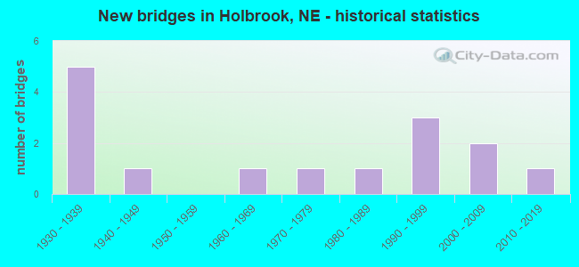
- New bridges - historical statistics
- 51930-1939
- 11940-1949
- 11960-1969
- 11970-1979
- 11980-1989
- 31990-1999
- 22000-2009
- 12010-2019

- Reconstructed bridges - Historical Statistics
- 11980-1989
- 11990-1999
- 12000-2009

- Bridge Condition - Deck
- 10.0%Excellent
- 10.0%Very good
- 10.0%Good
- 20.0%Satisfactory
- 40.0%Fair
- 10.0%Poor

- Bridge Condition - Superstructure
- 10.0%Excellent
- 40.0%Very good
- 20.0%Satisfactory
- 10.0%Fair
- 20.0%Poor

- Bridge Condition - Substructure
- 10.0%Excellent
- 20.0%Very good
- 10.0%Good
- 20.0%Satisfactory
- 30.0%Poor
- 10.0%Serious

- Bridge Condition - Channel
- 14.3%Excellent
- 42.9%Very good
- 21.4%Good
- 7.1%Satisfactory
- 7.1%Fair
- 7.1%Poor

- Bridge Condition - Culverts
- 40.0%Excellent
- 40.0%Very good
- 20.0%Good
Find on map >> Show street view
Structure Number: NKA-CAMB-004, Location: 5.6 mi E NE of Cambridge (Lat: 40.301900, Lng: -100.062381), Route carried "on" structure: ServiceOther road , Year Built: 1963, Status: Open, Structure Length: 1.02m (3.35ft), Average Daily Traffic: 3 (year 2014), Average Future Daily Traffic: 3 (year 2040), Features Intersected: Cambridge Canal, Facility Carried by Structure: Rd 415
Minimum Vertical Clearance: 30+ m (98+ ft), Kilometerpoint: 0.000, Lanes on structure: 2, Owner: Bureau of Reclamation, Maintenance Responsibility: State Agenciy, Approaching Roadway Width: 7.2m (23.6ft), Material/Design: Steel, Design/Construction: Stringer/Multi-beam, Number Of Spans In Main Unit: 1, Length of Maximum Span: 9.5m (31.2ft), Curb-To-Curb Width: 7.2m (23.6ft), Out-to-Out Width: 7.2m (23.6ft)
Condition: Deck: Satisfactory, Superstructure: Poor, Substructure: Poor, Channel: Fair, Operating Rating: 33.3 metric tons, Method Used To Determine Operating Rating: Allowable Stress (AS), Inventory Rating: 22.5 metric tons, Method Used To Determine Inventory Rating: Allowable Stress (AS), Structural Evaluation: Meets minimum limits, Deck Geometry: Somewhat better than minimum adequacy, Waterway Adequacy: Superior to present desirable criteria, Approach Roadway Alignment: Equal to present minimum criteria, Designated Inspection Frequency: Every 24 months, Inspection Date: June 2020, Bridge Improvement Cost: $21,000, Roadway Improvement Cost: $42,000, Total Project Cost: $63,000 ( Estimate for 2019), Deck Structure Type: Concrete Cast-file-Place
Find on map >> Show street view
Structure Number: NKA-CAMB-013, Location: 1.7 mi NE of Holbrook (Lat: 40.321472, Lng: -99.990167), Route carried "on" structure: County highway 724, Year Built: 1949, Year Reconstructed: 1996, Status: Open, Structure Length: 0.63m (2.07ft), Average Daily Traffic: 20 (year 2014), Average Future Daily Traffic: 25 (year 2040), Features Intersected: Cambridge Canal
Minimum Vertical Clearance: 30+ m (98+ ft), Kilometerpoint: 0.000, Lanes on structure: 2, Owner: Bureau of Reclamation, Maintenance Responsibility: Local Agency, Approaching Roadway Width: 8.2m (26.9ft), Material/Design: Concrete continuous, Design/Construction: Culvert, Number Of Spans In Main Unit: 2, Length of Maximum Span: 3.2m (10.5ft), Curb-To-Curb Width: 8.2m (26.9ft), Out-to-Out Width: 8.2m (26.9ft)
Condition: Channel: Satisfactory, Culverts: Good, Operating Rating: 32.4 metric tons, Method Used To Determine Operating Rating: Load Factor (LF), Inventory Rating: 21.6 metric tons, Method Used To Determine Inventory Rating: Load Factor (LF), Structural Evaluation: Equal to present minimum criteria, Deck Geometry: Equal to present minimum criteria, Waterway Adequacy: Superior to present desirable criteria, Approach Roadway Alignment: Equal to present desirable criteria, Designated Inspection Frequency: Every 24 months, Inspection Date: June 2020, Roadway Improvement Cost: $2,000, Total Project Cost: $2,000 ( Estimate for 2020)
Find on map >> Show street view
Structure Number: C00330061, Location: .5W 1N OF HOLBROOK (Lat: 40.321700, Lng: -100.026900), Route carried "on" structure: County highway 6, Year Built: 1935, Status: Posted for load, Structure Length: 1.62m (5.31ft), Average Daily Traffic: 40 (year 2003), Average Future Daily Traffic: 68 (year 2033), Features Intersected: DEER CREEK, Facility Carried by Structure: ROAD 724
Minimum Vertical Clearance: 30+ m (98+ ft), Kilometerpoint: 0.000, Lanes on structure: 1, Owner: County Highway Agency, Approaching Roadway Width: 5.5m (18.0ft), Material/Design: Steel, Design/Construction: Truss - Thru, Number Of Spans In Main Unit: 1, Length of Maximum Span: 15.2m (49.9ft), Curb or Sidewalk Widths: Left: 0.2m (0.7ft), Right: 0.2m (0.7ft), Curb-To-Curb Width: 4.6m (15.1ft), Out-to-Out Width: 4.9m (16.1ft)
Condition: Deck: Poor, Superstructure: Fair, Substructure: Serious, Channel: Poor, Operating Rating: 10.0 metric tons, Method Used To Determine Operating Rating: Load Factor (LF), Inventory Rating: 5.0 metric tons, Method Used To Determine Inventory Rating: Load Factor (LF), Structural Evaluation: High priority of replacement, Deck Geometry: Better than present minimum criteria, Waterway Adequacy: Meets minimum limits, Approach Roadway Alignment: High priority of corrective action, Bridge Posting: Required (Relationship of Operating Rating to Maximum Legal Load: > 39.9% below), Length Of Structure Improvement: 1.62m (5.31ft), Designated Inspection Frequency: Every 24 months, Critical Feature Inspection Frequency: Every 24 months, Other Special Inspection Frequency: Every 24 months, Inspection Date: October 2021, Critical Feature Inspection Date: October 2021, Other Special Inspection Date: October 2020, Deck Structure Type: Concrete Cast-file-Place, Wearing Surface/Protective System: Wearing Surface: Monolithic Concrete
Find on map >> Show street view
Structure Number: C003300615, Location: 1E 1N OF HOLBROOK (Lat: 40.321700, Lng: -99.990000), Route carried "on" structure: County highway 6, Year Built: 1996, Status: Open, Structure Length: 0.64m (2.10ft), Average Daily Traffic: 50 (year 2003), Average Future Daily Traffic: 65 (year 2033), Design Load: HS 20, Features Intersected: CAMBRIDGE-OXFORD-ORLEANS, Facility Carried by Structure: COUNTY HIGHWAY
Minimum Vertical Clearance: 30+ m (98+ ft), Kilometerpoint: 0.000, Lanes on structure: 2, Owner: Local Agency, Approaching Roadway Width: 6.7m (22.0ft), Material/Design: Concrete, Design/Construction: Culvert, Number Of Spans In Main Unit: 2, Length of Maximum Span: 3.0m (9.8ft)
Condition: Channel: Excellent, Culverts: Excellent, Operating Rating: 33.0 metric tons, Method Used To Determine Operating Rating: Field evaluation and documented engineering judgment, Inventory Rating: 22.0 metric tons, Method Used To Determine Inventory Rating: Field evaluation and documented engineering judgment, Structural Evaluation: Equal to present minimum criteria, Waterway Adequacy: Superior to present desirable criteria, Approach Roadway Alignment: Superior to present desirable criteria, Designated Inspection Frequency: Every 24 months, Inspection Date: November 2020
Find on map >> Show street view
Structure Number: C00330121, Location: JCT US6/US283 2S 6.1W (Lat: 40.278000, Lng: -100.010700), Route carried "on" structure: County highway 1450, Year Built: 1991, Status: Open, Structure Length: 0.76m (2.49ft), Average Daily Traffic: 145 (year 2011), Average Future Daily Traffic: 145 (year 2042), Features Intersected: TIMMONS CREEK
Minimum Vertical Clearance: 30+ m (98+ ft), Kilometerpoint: 5.959, Lanes on structure: 2, Owner: County Highway Agency, Approaching Roadway Width: 7.6m (24.9ft), Material/Design: Concrete, Design/Construction: Culvert, Number Of Spans In Main Unit: 2, Length of Maximum Span: 3.7m (12.1ft)
Condition: Culverts: Very good, Operating Rating: 33.0 metric tons, Method Used To Determine Operating Rating: Field evaluation and documented engineering judgment, Inventory Rating: 22.0 metric tons, Method Used To Determine Inventory Rating: Field evaluation and documented engineering judgment, Structural Evaluation: Equal to present minimum criteria, Waterway Adequacy: Equal to present desirable criteria, Approach Roadway Alignment: Equal to present desirable criteria, Designated Inspection Frequency: Every 24 months, Inspection Date: November 2021
Find on map >> Show street view
Structure Number: C003311725, Location: 1.5W 2N OF HOLBROOK (Lat: 40.338600, Lng: -100.043200), Route carried "on" structure: County highway 7349, Year Built: 2007, Status: Open, Structure Length: 3.05m (10.01ft), Average Daily Traffic: 110 (year 2002), Truck Traffic: 10%, Average Future Daily Traffic: 187 (year 2042), Features Intersected: DEER CREEK
Minimum Vertical Clearance: 30+ m (98+ ft), Kilometerpoint: 0.348, Lanes on structure: 2, Owner: County Highway Agency, Approaching Roadway Width: 8.5m (27.9ft), Material/Design: Concrete continuous, Design/Construction: Slab, Number Of Spans In Main Unit: 3, Length of Maximum Span: 12.2m (40.0ft), Curb-To-Curb Width: 8.5m (27.9ft), Out-to-Out Width: 9.3m (30.5ft)
Condition: Deck: Excellent, Superstructure: Excellent, Substructure: Excellent, Channel: Very good, Operating Rating: 98.0 metric tons, Method Used To Determine Operating Rating: Load Factor (LF), Inventory Rating: 55.0 metric tons, Method Used To Determine Inventory Rating: Load Factor (LF), Structural Evaluation: Superior to present desirable criteria, Deck Geometry: Equal to present minimum criteria, Waterway Adequacy: Superior to present desirable criteria, Approach Roadway Alignment: Equal to present desirable criteria, Length Of Structure Improvement: 1.10m (3.61ft), Designated Inspection Frequency: Every 24 months, Inspection Date: November 2021, Deck Structure Type: Concrete Cast-file-Place, Wearing Surface/Protective System: Wearing Surface: Monolithic Concrete
Find on map >> Show street view
Structure Number: C00332041, Location: 1.5W 2N OF HOLBROOK (Lat: 40.336600, Lng: -100.039400), Route carried "on" structure: County highway 204, Year Built: 1935, Status: Posted for load, Structure Length: 0.94m (3.08ft), Average Daily Traffic: 25 (year 2003), Average Future Daily Traffic: 42 (year 2042), Features Intersected: DEER CREEK, Facility Carried by Structure: COUNTY HIGHWAY
Minimum Vertical Clearance: 30+ m (98+ ft), Kilometerpoint: 0.000, Lanes on structure: 2, Owner: County Highway Agency, Approaching Roadway Width: 6.7m (22.0ft), Material/Design: Steel, Design/Construction: Stringer/Multi-beam, Number Of Spans In Main Unit: 1, Length of Maximum Span: 8.8m (28.9ft), Curb-To-Curb Width: 4.9m (16.1ft), Out-to-Out Width: 4.9m (16.1ft)
Condition: Deck: Fair, Superstructure: Poor, Substructure: Poor, Channel: Very good, Operating Rating: 26.0 metric tons, Method Used To Determine Operating Rating: Load Factor (LF), Inventory Rating: 15.0 metric tons, Method Used To Determine Inventory Rating: Load Factor (LF), Structural Evaluation: Meets minimum limits, Deck Geometry: High priority of corrective action, Waterway Adequacy: Somewhat better than minimum adequacy, Approach Roadway Alignment: Equal to present minimum criteria, Bridge Posting: Required (Relationship of Operating Rating to Maximum Legal Load: > 39.9% below), Length Of Structure Improvement: 0.94m (3.08ft), Designated Inspection Frequency: Every 24 months, Inspection Date: November 2021, Deck Structure Type: Wood or Timber, Wearing Surface/Protective System: Wearing Surface: Gravel
Find on map >> Show street view
Structure Number: C003322125, Location: JCT US6/US283 1S 5.8W (Lat: 40.291700, Lng: -100.005000), Route carried "on" structure: County highway 1655, Year Built: 1992, Status: Open, Structure Length: 0.98m (3.22ft), Average Daily Traffic: 210 (year 2011), Average Future Daily Traffic: 210 (year 2033), Design Load: HS 20, Features Intersected: TIMMONS CREEK
Minimum Vertical Clearance: 30+ m (98+ ft), Kilometerpoint: 3.776, Lanes on structure: 2, Owner: County Highway Agency, Approaching Roadway Width: 6.7m (22.0ft), Skew: 3 degrees, Material/Design: Concrete, Design/Construction: Culvert, Number Of Spans In Main Unit: 2, Length of Maximum Span: 4.0m (13.1ft)
Condition: Channel: Very good, Culverts: Very good, Operating Rating: 33.0 metric tons, Method Used To Determine Operating Rating: Field evaluation and documented engineering judgment, Inventory Rating: 22.0 metric tons, Method Used To Determine Inventory Rating: Field evaluation and documented engineering judgment, Structural Evaluation: Equal to present minimum criteria, Waterway Adequacy: Equal to present desirable criteria, Approach Roadway Alignment: Superior to present desirable criteria, Designated Inspection Frequency: Every 24 months, Inspection Date: November 2020
Find on map >> Show street view
Structure Number: C00332213, Location: JCT US6/US283 .5S 5.8W (Lat: 40.298500, Lng: -100.007000), Route carried "on" structure: County highway 1655, Year Built: 1972, Status: Open, Structure Length: 9.33m (30.61ft), Average Daily Traffic: 210 (year 2011), Average Future Daily Traffic: 210 (year 2033), Features Intersected: REPUBLICAN RIVER
Minimum Vertical Clearance: 30+ m (98+ ft), Kilometerpoint: 3.851, Lanes on structure: 2, Owner: County Highway Agency, Approaching Roadway Width: 7.9m (25.9ft), Material/Design: Steel, Design/Construction: Stringer/Multi-beam, Number Of Spans In Main Unit: 2, Number Of Approach Spans: 2, Length of Maximum Span: 23.2m (76.1ft), Curb-To-Curb Width: 8.5m (27.9ft), Out-to-Out Width: 8.5m (27.9ft)
Condition: Deck: Satisfactory, Superstructure: Satisfactory, Substructure: Satisfactory, Channel: Good, Operating Rating: 44.0 metric tons, Method Used To Determine Operating Rating: Load Factor (LF), Inventory Rating: 26.0 metric tons, Method Used To Determine Inventory Rating: Load Factor (LF), Structural Evaluation: Equal to present minimum criteria, Deck Geometry: Equal to present minimum criteria, Waterway Adequacy: Equal to present desirable criteria, Approach Roadway Alignment: Equal to present minimum criteria, Designated Inspection Frequency: Every 24 months, Inspection Date: November 2020, Deck Structure Type: Concrete Cast-file-Place, Wearing Surface/Protective System: Wearing Surface: Monolithic Concrete
Find on map >> Show street view
Structure Number: C003322335, Location: 1E 1.2N OF HOLBROOK (Lat: 40.322200, Lng: -99.986300), Route carried "on" structure: County highway 223, Year Built: 1935, Status: Posted for load, Structure Length: 1.01m (3.31ft), Average Daily Traffic: 10 (year 2003), Average Future Daily Traffic: 17 (year 2033), Features Intersected: CAMBRIDGE-OXFORD-ORLEANS, Facility Carried by Structure: COUNTY HIGHWAY
Minimum Vertical Clearance: 30+ m (98+ ft), Kilometerpoint: 0.000, Lanes on structure: 2, Owner: Local Agency, Approaching Roadway Width: 6.4m (21.0ft), Material/Design: Wood or Timber, Design/Construction: Stringer/Multi-beam, Number Of Spans In Main Unit: 1, Length of Maximum Span: 9.4m (30.8ft), Curb-To-Curb Width: 6.1m (20.0ft), Out-to-Out Width: 6.2m (20.3ft)
Condition: Deck: Fair, Superstructure: Satisfactory, Substructure: Satisfactory, Channel: Good, Operating Rating: 10.0 metric tons, Method Used To Determine Operating Rating: Allowable Stress (AS), Inventory Rating: 5.0 metric tons, Method Used To Determine Inventory Rating: Allowable Stress (AS), Structural Evaluation: High priority of replacement, Deck Geometry: Somewhat better than minimum adequacy, Waterway Adequacy: Equal to present desirable criteria, Approach Roadway Alignment: Better than present minimum criteria, Bridge Posting: Required (Relationship of Operating Rating to Maximum Legal Load: > 39.9% below), Length Of Structure Improvement: 1.01m (3.31ft), Designated Inspection Frequency: Every 24 months, Inspection Date: November 2020, Deck Structure Type: Wood or Timber, Wearing Surface/Protective System: Wearing Surface: Gravel
Find on map >> Show street view
Structure Number: C003322525, Location: 2E 1N OF HOLBROOK (Lat: 40.323300, Lng: -99.968300), Route carried "on" structure: County highway 225, Year Built: 1935, Year Reconstructed: 2007, Status: Open, Structure Length: 1.01m (3.31ft), Average Daily Traffic: 20 (year 2003), Average Future Daily Traffic: 34 (year 2042), Features Intersected: CAMBRIDGE-OXFORD-ORLEANS, Facility Carried by Structure: COUNTY HIGHWAY
Minimum Vertical Clearance: 30+ m (98+ ft), Kilometerpoint: 0.000, Lanes on structure: 2, Owner: Local Agency, Approaching Roadway Width: 6.7m (22.0ft), Material/Design: Steel, Design/Construction: Stringer/Multi-beam, Number Of Spans In Main Unit: 1, Length of Maximum Span: 9.4m (30.8ft), Curb-To-Curb Width: 6.5m (21.3ft), Out-to-Out Width: 6.8m (22.3ft)
Condition: Deck: Fair, Superstructure: Very good, Substructure: Good, Channel: Excellent, Operating Rating: 54.0 metric tons, Method Used To Determine Operating Rating: Load Factor (LF), Inventory Rating: 32.0 metric tons, Method Used To Determine Inventory Rating: Load Factor (LF), Structural Evaluation: Better than present minimum criteria, Deck Geometry: Somewhat better than minimum adequacy, Waterway Adequacy: Equal to present desirable criteria, Approach Roadway Alignment: Equal to present desirable criteria, Length Of Structure Improvement: 1.01m (3.31ft), Designated Inspection Frequency: Every 24 months, Inspection Date: November 2021, Deck Structure Type: Concrete Cast-file-Place, Wearing Surface/Protective System: Wearing Surface: Gravel
Find on map >> Show street view
Structure Number: C00333191, Location: .5W .5N OF HOLBROOK (Lat: 40.313300, Lng: -100.023300), Route carried "on" structure: County highway 319, Year Built: 1935, Year Reconstructed: 1989, Status: Open, Structure Length: 1.43m (4.69ft), Average Daily Traffic: 30 (year 2003), Average Future Daily Traffic: 51 (year 2042), Features Intersected: CAMBRIDGE-OXFORD-ORLEANS, Facility Carried by Structure: COUNTY HIGHWAY
Minimum Vertical Clearance: 30+ m (98+ ft), Kilometerpoint: 0.000, Lanes on structure: 2, Owner: Local Agency, Approaching Roadway Width: 7.3m (24.0ft), Skew: 4 degrees, Material/Design: Prestressed concrete, Design/Construction: Tee Beam, Number Of Spans In Main Unit: 1, Length of Maximum Span: 14.0m (45.9ft), Curb-To-Curb Width: 8.4m (27.6ft), Out-to-Out Width: 9.1m (29.9ft)
Condition: Deck: Fair, Superstructure: Very good, Substructure: Poor, Channel: Very good, Operating Rating: 47.0 metric tons, Method Used To Determine Operating Rating: Load Factor (LF), Inventory Rating: 28.0 metric tons, Method Used To Determine Inventory Rating: Load Factor (LF), Structural Evaluation: Meets minimum limits, Deck Geometry: Equal to present minimum criteria, Waterway Adequacy: Somewhat better than minimum adequacy, Approach Roadway Alignment: Equal to present desirable criteria, Length Of Structure Improvement: 1.43m (4.69ft), Designated Inspection Frequency: Every 24 months, Inspection Date: November 2021, Deck Structure Type: Concrete Cast-file-Place, Wearing Surface/Protective System: Wearing Surface: Monolithic Concrete
Find on map >> Show street view
Structure Number: C003331915, Location: .5W 1N OF HOLBROOK (Lat: 40.320000, Lng: -100.023300), Route carried "on" structure: County highway 319, Year Built: 1986, Status: Open, Structure Length: 3.41m (11.19ft), Average Daily Traffic: 30 (year 2003), Average Future Daily Traffic: 51 (year 2040), Design Load: HS 20, Features Intersected: DEER CREEK, Facility Carried by Structure: COUNTY HIGHWAY
Minimum Vertical Clearance: 30+ m (98+ ft), Kilometerpoint: 0.000, Lanes on structure: 2, Owner: County Highway Agency, Approaching Roadway Width: 8.5m (27.9ft), Material/Design: Concrete continuous, Design/Construction: Slab, Number Of Spans In Main Unit: 3, Length of Maximum Span: 13.4m (44.0ft), Curb-To-Curb Width: 8.5m (27.9ft), Out-to-Out Width: 9.2m (30.2ft)
Condition: Deck: Good, Superstructure: Very good, Substructure: Very good, Channel: Very good, Operating Rating: 65.0 metric tons, Method Used To Determine Operating Rating: Load Factor (LF), Inventory Rating: 34.0 metric tons, Method Used To Determine Inventory Rating: Load Factor (LF), Structural Evaluation: Equal to present desirable criteria, Deck Geometry: Better than present minimum criteria, Waterway Adequacy: Equal to present desirable criteria, Approach Roadway Alignment: Equal to present desirable criteria, Designated Inspection Frequency: Every 24 months, Inspection Date: November 2021, Deck Structure Type: Concrete Cast-file-Place, Wearing Surface/Protective System: Wearing Surface: Monolithic Concrete
Find on map >> Show street view
Structure Number: S006 12071, Location: 0E HOLBROOK (Lat: 40.306900, Lng: -100.005700), Route carried "on" structure: US 6, Year Built: 2005, Status: Open, Structure Length: 6.49m (21.29ft), Average Daily Traffic: 2,475 (year 2018), Truck Traffic: 16%, Average Future Daily Traffic: 3,465 (year 2038), Design Load: HL 93, Features Intersected: DEER CREEK
Minimum Vertical Clearance: 30+ m (98+ ft), Kilometerpoint: 19.426, Lanes on structure: 2, Base Highway Network: Yes, Owner: State Highway Agency, Approaching Roadway Width: 13.4m (44.0ft), Skew: 4 degrees, Material/Design: Prestressed concrete continuous, Design/Construction: Stringer/Multi-beam, Number Of Spans In Main Unit: 3, Length of Maximum Span: 25.9m (85.0ft), Curb-To-Curb Width: 13.4m (44.0ft), Out-to-Out Width: 14.1m (46.3ft)
Condition: Deck: Very good, Superstructure: Very good, Substructure: Very good, Channel: Very good, Operating Rating: 44.0 metric tons, Method Used To Determine Operating Rating: Load and Resistance Factor (LRFR), Inventory Rating: 34.0 metric tons, Method Used To Determine Inventory Rating: Load and Resistance Factor (LRFR), Structural Evaluation: Equal to present desirable criteria, Deck Geometry: Better than present minimum criteria, Waterway Adequacy: Superior to present desirable criteria, Approach Roadway Alignment: Equal to present desirable criteria, Designated Inspection Frequency: Every 48 months, Inspection Date: April 2019, Deck Structure Type: Concrete Cast-file-Place, Wearing Surface/Protective System: Wearing Surface: Monolithic Concrete, Deck Protection: Epoxy Coated Reinforcing
Find on map >> Show street view
Structure Number: S006 12326, Location: 3E HOLBROOK (Lat: 40.306800, Lng: -99.957400), Route carried "on" structure: US 6, Year Built: 2019, Status: Open, Structure Length: 2.35m (7.71ft), Average Daily Traffic: 2,475 (year 2018), Truck Traffic: 16%, Average Future Daily Traffic: 3,465 (year 2038), Design Load: HL 93, Features Intersected: REPUBLICAN RIVER TRIB
Minimum Vertical Clearance: 30+ m (98+ ft), Kilometerpoint: 19.837, Lanes on structure: 2, Base Highway Network: Yes, Owner: State Highway Agency, Approaching Roadway Width: 13.4m (44.0ft), Material/Design: Concrete, Design/Construction: Culvert, Number Of Spans In Main Unit: 4, Length of Maximum Span: 9.4m (30.8ft)
Condition: Channel: Good, Culverts: Excellent, Operating Rating: 63.0 metric tons, Method Used To Determine Operating Rating: Load and Resistance Factor (LRFR), Inventory Rating: 48.0 metric tons, Method Used To Determine Inventory Rating: Load and Resistance Factor (LRFR), Structural Evaluation: Superior to present desirable criteria, Waterway Adequacy: Equal to present desirable criteria, Approach Roadway Alignment: Equal to present desirable criteria, Length Of Structure Improvement: 2.35m (7.71ft), Designated Inspection Frequency: Every 24 months, Inspection Date: April 2021