Bridge Statistics for Hillrose, Colorado (CO)
Condition, Traffic, Stress, Structural Evaluation, Project Costs
- National Bridge Inventory (NBI) Statistics
- 15Number of bridges
- 144ft / 44.2mTotal length
- 26,098Total average daily traffic
- 4,849Total average daily truck traffic
- National Bridge Inventory (NBI) Registered Bridges for Hillrose
- No street view available for this location
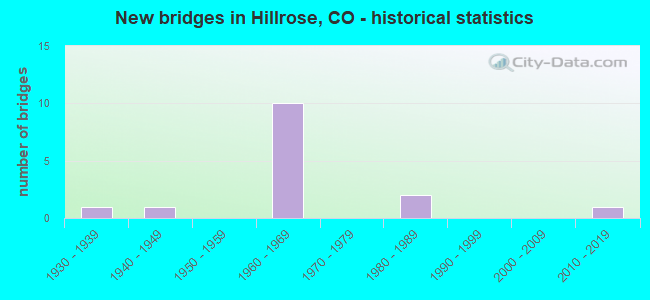
- New bridges - historical statistics
- 11930-1939
- 11940-1949
- 101960-1969
- 21980-1989
- 12010-2019


- Bridge Condition - Deck
- 18.2%Very good
- 18.2%Good
- 54.5%Satisfactory
- 9.1%Fair

- Bridge Condition - Superstructure
- 9.1%Very good
- 18.2%Good
- 36.4%Satisfactory
- 36.4%Fair

- Bridge Condition - Substructure
- 9.1%Very good
- 27.3%Satisfactory
- 63.6%Fair

- Bridge Condition - Channel
- 14.3%Very good
- 57.1%Good
- 28.6%Satisfactory
Find on map >> Show street view
Structure Number: C-22-BL, Location: 3.7 MI NE OF JCT US 34-B (Lat: 40.301231, Lng: -103.527269), Route carried "on" structure: Interstate 76A, Year Built: 1964, Status: Open, Structure Length: 3.51m (11.52ft), Average Daily Traffic: 5,500 (year 2020), Truck Traffic: 19%, Average Future Daily Traffic: 7,645 (year 2040), Design Load: HS 20+Mod, Features Intersected: COUNTY ROAD 33, Facility Carried by Structure: I 76 ML EBND
Minimum Vertical Clearance: 30+ m (98+ ft), Kilometerpoint: 153.340, Lanes on structure: 2, Lanes under structure: 2, Base Highway Network: Yes, Owner: State Highway Agency, Approaching Roadway Width: 11.6m (38.1ft), Skew: 10 degrees, Material/Design: Concrete, Design/Construction: Tee Beam, Number Of Spans In Main Unit: 3, Length of Maximum Span: 11.3m (37.1ft), Curb-To-Curb Width: 11.8m (38.7ft), Out-to-Out Width: 12.8m (42.0ft)
Condition: Deck: Satisfactory, Superstructure: Satisfactory, Substructure: Fair, Operating Rating: 66.0 metric tons, Method Used To Determine Operating Rating: Load Factor (LF), Inventory Rating: 39.5 metric tons, Method Used To Determine Inventory Rating: Load Factor (LF), Structural Evaluation: Somewhat better than minimum adequacy, Deck Geometry: Equal to present minimum criteria, Underclear: Meets minimum limits, Approach Roadway Alignment: Equal to present desirable criteria, Designated Inspection Frequency: Every 24 months, Inspection Date: June 2021, Deck Structure Type: Concrete Cast-file-Place, Wearing Surface/Protective System: Wearing Surface: Bituminous, Membrane: Preformed Fabric
Find on map >> Show street view
Structure Number: C-22-BM, Location: 5 MI E. OF BRUSH (Lat: 40.301511, Lng: -103.527553), Route carried "on" structure: Interstate 76A, Year Built: 1964, Status: Open, Structure Length: 3.51m (11.52ft), Average Daily Traffic: 5,500 (year 2020), Truck Traffic: 19%, Average Future Daily Traffic: 7,645 (year 2040), Design Load: HS 20+Mod, Features Intersected: COUNTY ROAD 33, Facility Carried by Structure: I 76 ML WBND
Minimum Vertical Clearance: 30+ m (98+ ft), Kilometerpoint: 153.340, Lanes on structure: 2, Lanes under structure: 2, Base Highway Network: Yes, Owner: State Highway Agency, Approaching Roadway Width: 11.6m (38.1ft), Skew: 10 degrees, Material/Design: Concrete, Design/Construction: Tee Beam, Number Of Spans In Main Unit: 3, Length of Maximum Span: 11.3m (37.1ft), Curb-To-Curb Width: 11.6m (38.1ft), Out-to-Out Width: 12.8m (42.0ft)
Condition: Deck: Satisfactory, Superstructure: Good, Substructure: Satisfactory, Operating Rating: 66.0 metric tons, Method Used To Determine Operating Rating: Load Factor (LF), Inventory Rating: 39.5 metric tons, Method Used To Determine Inventory Rating: Load Factor (LF), Structural Evaluation: Equal to present minimum criteria, Deck Geometry: Equal to present minimum criteria, Underclear: Meets minimum limits, Approach Roadway Alignment: Equal to present desirable criteria, Designated Inspection Frequency: Every 24 months, Inspection Date: June 2021, Deck Structure Type: Concrete Cast-file-Place, Wearing Surface/Protective System: Wearing Surface: Bituminous, Membrane: Preformed Fabric
Find on map >> Show street view
Structure Number: C-22-F, Location: 3.2 MI NE OF JCTI76BRUSH (Lat: 40.306056, Lng: -103.547139), Route carried "on" structure: US 6J, Year Built: 1941, Status: Open, Structure Length: 0.82m (2.69ft), Average Daily Traffic: 1,400 (year 2020), Truck Traffic: 11%, Average Future Daily Traffic: 2,044 (year 2040), Design Load: HS 20, Features Intersected: LWR PLATTE,BEAVER CANAL, Facility Carried by Structure: US 6 ML
Minimum Vertical Clearance: 30+ m (98+ ft), Kilometerpoint: 2.514, Lanes on structure: 2, Owner: State Highway Agency, Approaching Roadway Width: 8.5m (27.9ft), Material/Design: Steel, Design/Construction: Stringer/Multi-beam, Number Of Spans In Main Unit: 1, Length of Maximum Span: 7.6m (24.9ft), Curb-To-Curb Width: 9.1m (29.9ft), Out-to-Out Width: 10.4m (34.1ft)
Condition: Deck: Fair, Superstructure: Good, Substructure: Satisfactory, Channel: Very good, Operating Rating: 27.2 metric tons, Method Used To Determine Operating Rating: Load Factor (LF), Inventory Rating: 16.3 metric tons, Method Used To Determine Inventory Rating: Load Factor (LF), Structural Evaluation: Meets minimum limits, Deck Geometry: Somewhat better than minimum adequacy, Waterway Adequacy: Equal to present desirable criteria, Approach Roadway Alignment: Equal to present desirable criteria, Designated Inspection Frequency: Every 24 months, Inspection Date: November 2021, Deck Structure Type: Concrete Cast-file-Place, Wearing Surface/Protective System: Wearing Surface: Bituminous
Find on map >> Show street view
Structure Number: C-22-J, Location: 1.6 MI NE OF JCT I-76 (Lat: 40.306006, Lng: -103.547147), Route carried "on" structure: US 6J, Year Built: 1932, Status: Open, Structure Length: 4.24m (13.91ft), Average Daily Traffic: 1,400 (year 2020), Truck Traffic: 11%, Average Future Daily Traffic: 2,044 (year 2040), Design Load: H 15, Features Intersected: BEAVER CREEK, Facility Carried by Structure: US 6 ML
Minimum Vertical Clearance: 30+ m (98+ ft), Kilometerpoint: 4.991, Lanes on structure: 2, Owner: State Highway Agency, Approaching Roadway Width: 7.3m (24.0ft), Skew: 3 degrees, Material/Design: Wood or Timber, Design/Construction: Stringer/Multi-beam, Number Of Spans In Main Unit: 6, Length of Maximum Span: 7.0m (23.0ft), Curb-To-Curb Width: 7.6m (24.9ft), Out-to-Out Width: 7.9m (25.9ft)
Condition: Deck: Satisfactory, Superstructure: Fair, Substructure: Fair, Channel: Good, Operating Rating: 37.6 metric tons, Method Used To Determine Operating Rating: Allowable Stress (AS), Inventory Rating: 26.1 metric tons, Method Used To Determine Inventory Rating: Allowable Stress (AS), Structural Evaluation: Somewhat better than minimum adequacy, Deck Geometry: Meets minimum limits, Waterway Adequacy: Equal to present desirable criteria, Approach Roadway Alignment: Equal to present desirable criteria, Designated Inspection Frequency: Every 24 months, Inspection Date: August 2021, Deck Structure Type: Corrugated Steel, Wearing Surface/Protective System: Wearing Surface: Bituminous
Find on map >> Show street view
Structure Number: C-23-AS, Location: 9 MI E. OF BRUSH (Lat: 40.333914, Lng: -103.471925), Route carried "on" structure: Interstate 76A, Year Built: 1964, Status: Open, Structure Length: 3.51m (11.52ft), Average Daily Traffic: 5,500 (year 2020), Truck Traffic: 19%, Average Future Daily Traffic: 7,645 (year 2040), Design Load: HS 20+Mod, Features Intersected: COUNTY ROADS X,36, Facility Carried by Structure: I 76 ML WBND
Minimum Vertical Clearance: 30+ m (98+ ft), Kilometerpoint: 159.282, Lanes on structure: 2, Lanes under structure: 2, Base Highway Network: Yes, Owner: State Highway Agency, Approaching Roadway Width: 11.6m (38.1ft), Skew: 10 degrees, Material/Design: Concrete, Design/Construction: Tee Beam, Number Of Spans In Main Unit: 3, Length of Maximum Span: 11.3m (37.1ft), Curb-To-Curb Width: 11.6m (38.1ft), Out-to-Out Width: 12.8m (42.0ft)
Condition: Deck: Satisfactory, Superstructure: Satisfactory, Substructure: Fair, Operating Rating: 64.7 metric tons, Method Used To Determine Operating Rating: Load Factor (LF), Inventory Rating: 38.7 metric tons, Method Used To Determine Inventory Rating: Load Factor (LF), Structural Evaluation: Somewhat better than minimum adequacy, Deck Geometry: Equal to present minimum criteria, Underclear: Meets minimum limits, Approach Roadway Alignment: Equal to present desirable criteria, Designated Inspection Frequency: Every 24 months, Inspection Date: June 2021, Deck Structure Type: Concrete Cast-file-Place, Wearing Surface/Protective System: Wearing Surface: Bituminous, Membrane: Preformed Fabric
Find on map >> Show street view
Structure Number: C-23-AT, Location: 7.4 MI N OF JCT US 34, BR (Lat: 40.333628, Lng: -103.471650), Route carried "on" structure: Interstate 76A, Year Built: 1964, Status: Open, Structure Length: 3.51m (11.52ft), Average Daily Traffic: 5,500 (year 2020), Truck Traffic: 19%, Average Future Daily Traffic: 7,645 (year 2040), Design Load: HS 20, Features Intersected: COUNTY ROADS X,36, Facility Carried by Structure: I 76 ML EBND
Minimum Vertical Clearance: 30+ m (98+ ft), Kilometerpoint: 159.282, Lanes on structure: 2, Lanes under structure: 2, Base Highway Network: Yes, Owner: State Highway Agency, Approaching Roadway Width: 11.6m (38.1ft), Skew: 10 degrees, Material/Design: Concrete, Design/Construction: Tee Beam, Number Of Spans In Main Unit: 3, Length of Maximum Span: 11.3m (37.1ft), Curb-To-Curb Width: 11.8m (38.7ft), Out-to-Out Width: 12.8m (42.0ft)
Condition: Deck: Satisfactory, Superstructure: Satisfactory, Substructure: Fair, Operating Rating: 64.7 metric tons, Method Used To Determine Operating Rating: Load Factor (LF), Inventory Rating: 38.7 metric tons, Method Used To Determine Inventory Rating: Load Factor (LF), Structural Evaluation: Somewhat better than minimum adequacy, Deck Geometry: Equal to present minimum criteria, Underclear: High priority of corrective action, Approach Roadway Alignment: Equal to present desirable criteria, Designated Inspection Frequency: Every 24 months, Inspection Date: June 2021, Deck Structure Type: Concrete Cast-file-Place, Wearing Surface/Protective System: Wearing Surface: Bituminous, Membrane: Preformed Fabric
Find on map >> Show street view
Structure Number: MG33-0.1-V, Location: 0.1 Mi N of Co Rd V (Lat: 40.306694, Lng: -103.528167), Route carried "on" structure: County highway , Year Built: 1965, Status: Open, Structure Length: 0.76m (2.49ft), Average Daily Traffic: 287 (year 2021), Truck Traffic: 33%, Average Future Daily Traffic: 364 (year 2041), Design Load: HS 20, Features Intersected: Lower Platte Beaver Cnl, Facility Carried by Structure: County Road 33
Minimum Vertical Clearance: 30+ m (98+ ft), Kilometerpoint: 0.646, Lanes on structure: 2, Owner: County Highway Agency, Approaching Roadway Width: 5.5m (18.0ft), Skew: 2 degrees, Material/Design: Steel, Design/Construction: Stringer/Multi-beam, Number Of Spans In Main Unit: 1, Length of Maximum Span: 6.9m (22.6ft), Curb-To-Curb Width: 7.3m (24.0ft), Out-to-Out Width: 7.3m (24.0ft)
Condition: Deck: Satisfactory, Superstructure: Fair, Substructure: Fair, Channel: Good, Operating Rating: 45.6 metric tons, Method Used To Determine Operating Rating: Load Factor (LF), Inventory Rating: 27.4 metric tons, Method Used To Determine Inventory Rating: Load Factor (LF), Structural Evaluation: Somewhat better than minimum adequacy, Deck Geometry: Somewhat better than minimum adequacy, Waterway Adequacy: Equal to present desirable criteria, Approach Roadway Alignment: Equal to present desirable criteria, Designated Inspection Frequency: Every 24 months, Inspection Date: November 2020, Deck Structure Type: Concrete Cast-file-Place, Wearing Surface/Protective System: Wearing Surface: Bituminous
Find on map >> Show street view
Structure Number: MG33-1.0-X.5-A, Location: 1.0 Mi N of Co Rd X (Lat: 40.355972, Lng: -103.527889), Route carried "on" structure: County highway , Year Built: 1987, Status: Open, Structure Length: 19.93m (65.39ft), Average Daily Traffic: 127 (year 2021), Truck Traffic: 42%, Average Future Daily Traffic: 161 (year 2041), Design Load: HS 20, Features Intersected: South Platte River, Facility Carried by Structure: County Road 33
Minimum Vertical Clearance: 30+ m (98+ ft), Kilometerpoint: 3.399, Lanes on structure: 2, Owner: County Highway Agency, Approaching Roadway Width: 6.1m (20.0ft), Material/Design: Steel, Design/Construction: Stringer/Multi-beam, Number Of Spans In Main Unit: 10, Length of Maximum Span: 19.6m (64.3ft), Curb-To-Curb Width: 8.3m (27.2ft), Out-to-Out Width: 9.2m (30.2ft)
Condition: Deck: Good, Superstructure: Fair, Substructure: Fair, Channel: Satisfactory, Operating Rating: 54.5 metric tons, Method Used To Determine Operating Rating: Load Factor (LF), Inventory Rating: 32.7 metric tons, Method Used To Determine Inventory Rating: Load Factor (LF), Structural Evaluation: Somewhat better than minimum adequacy, Deck Geometry: Somewhat better than minimum adequacy, Waterway Adequacy: Equal to present desirable criteria, Approach Roadway Alignment: Equal to present desirable criteria, Designated Inspection Frequency: Every 24 months, Inspection Date: November 2020, Deck Structure Type: Concrete Cast-file-Place, Wearing Surface/Protective System: Wearing Surface: Bituminous
Find on map >> Show street view
Structure Number: MGV-0.5-31A, Location: 0.5 Mi E of Co Rd 31 (Lat: 40.305778, Lng: -103.555750), Route carried "on" structure: County highway , Year Built: 2018, Status: Open, Structure Length: 1.20m (3.94ft), Average Daily Traffic: 66 (year 2021), Truck Traffic: 55%, Average Future Daily Traffic: 84 (year 2041), Design Load: HL 93, Features Intersected: Beaver Creek & Lpb C, Facility Carried by Structure: County Road V
Minimum Vertical Clearance: 30+ m (98+ ft), Kilometerpoint: 3.236, Lanes on structure: 2, Owner: County Highway Agency, Approaching Roadway Width: 6.1m (20.0ft), Skew: 4 degrees, Material/Design: Steel, Design/Construction: Stringer/Multi-beam, Number Of Spans In Main Unit: 1, Length of Maximum Span: 11.1m (36.4ft), Curb-To-Curb Width: 9.9m (32.5ft), Out-to-Out Width: 10.1m (33.1ft)
Condition: Deck: Very good, Superstructure: Very good, Substructure: Very good, Channel: Good, Operating Rating: 38.9 metric tons, Method Used To Determine Operating Rating: Load and Resistance Factor Rating (LRFR) rating reported by rating factor(RF) method using HL-93 loadings, Inventory Rating: 29.2 metric tons, Method Used To Determine Inventory Rating: Load and Resistance Factor Rating (LRFR) rating reported by rating factor(RF) method using HL-93 loadings, Structural Evaluation: Better than present minimum criteria, Deck Geometry: Superior to present desirable criteria, Waterway Adequacy: Better than present minimum criteria, Approach Roadway Alignment: Equal to present desirable criteria, Designated Inspection Frequency: Every 24 months, Inspection Date: November 2020, Deck Structure Type: Concrete Cast-file-Place, Wearing Surface/Protective System: Wearing Surface: Gravel
Find on map >> Show street view
Structure Number: MGW-0.9-31, Location: 0.9 Mi E of Co Rd 31 (Lat: 40.320611, Lng: -103.546000), Route carried "on" structure: County highway , Year Built: 1982, Status: Open, Structure Length: 1.24m (4.07ft), Average Daily Traffic: 238 (year 2021), Truck Traffic: 38%, Average Future Daily Traffic: 302 (year 2041), Design Load: HS 20, Features Intersected: Beaver Creek, Facility Carried by Structure: County Road W
Minimum Vertical Clearance: 30+ m (98+ ft), Kilometerpoint: 3.978, Lanes on structure: 2, Owner: County Highway Agency, Approaching Roadway Width: 5.5m (18.0ft), Material/Design: Steel, Design/Construction: Stringer/Multi-beam, Number Of Spans In Main Unit: 1, Length of Maximum Span: 11.8m (38.7ft), Curb-To-Curb Width: 8.5m (27.9ft), Out-to-Out Width: 8.5m (27.9ft)
Condition: Deck: Very good, Superstructure: Fair, Substructure: Satisfactory, Channel: Good, Operating Rating: 95.0 metric tons, Method Used To Determine Operating Rating: Load Factor (LF), Inventory Rating: 56.9 metric tons, Method Used To Determine Inventory Rating: Load Factor (LF), Structural Evaluation: Somewhat better than minimum adequacy, Deck Geometry: Equal to present minimum criteria, Waterway Adequacy: Better than present minimum criteria, Approach Roadway Alignment: Equal to present desirable criteria, Designated Inspection Frequency: Every 24 months, Inspection Date: November 2020, Deck Structure Type: Corrugated Steel, Wearing Surface/Protective System: Wearing Surface: Bituminous
Find on map >> Show street view
Structure Number: MGW.7-0.0-32, Location: 50 Ft E of Co Rd 32 (Lat: 40.354944, Lng: -103.540861), Route carried "on" structure: County highway , Year Built: 1965, Status: Open, Structure Length: 1.95m (6.40ft), Average Daily Traffic: 180 (year 2021), Truck Traffic: 49%, Average Future Daily Traffic: 229 (year 2041), Design Load: HS 20, Features Intersected: N. Sterling Inlet Canal, Facility Carried by Structure: County Road W.7
Minimum Vertical Clearance: 30+ m (98+ ft), Kilometerpoint: 5.409, Lanes on structure: 2, Owner: County Highway Agency, Approaching Roadway Width: 5.8m (19.0ft), Material/Design: Steel, Design/Construction: Stringer/Multi-beam, Number Of Spans In Main Unit: 2, Length of Maximum Span: 9.1m (29.9ft), Curb-To-Curb Width: 6.8m (22.3ft), Out-to-Out Width: 6.8m (22.3ft)
Condition: Deck: Good, Superstructure: Satisfactory, Substructure: Fair, Channel: Satisfactory, Operating Rating: 73.0 metric tons, Method Used To Determine Operating Rating: Load Factor (LF), Inventory Rating: 43.8 metric tons, Method Used To Determine Inventory Rating: Load Factor (LF), Structural Evaluation: Somewhat better than minimum adequacy, Deck Geometry: Meets minimum limits, Waterway Adequacy: Equal to present minimum criteria, Approach Roadway Alignment: Equal to present desirable criteria, Designated Inspection Frequency: Every 24 months, Inspection Date: November 2020, Deck Structure Type: Concrete Cast-file-Place, Wearing Surface/Protective System: Wearing Surface: Bituminous
Find on map >> Show street view
Structure Number: C-22-BL, Location: 3.7 MI NE OF JCT US 34-B (Lat: 40.301231, Lng: -103.527269), Route carried "under" structure: County highway , Year Built: 1964, Structure Length: 0. m, Average Daily Traffic: 100 (year 0000), Features Intersected: COUNTY ROAD 33, Facility Carried by Structure: I 76 ML EBND
Minimum Vertical Clearance: 5.30m (17.39ft), Kilometerpoint: 0.000, Lanes on structure: 2, Lanes under structure: 2, Material/Design: Concrete, Design/Construction: Tee Beam, Length of Maximum Span: 11.3m (37.1ft)
Find on map >> Show street view
Structure Number: C-22-BM, Location: 5 MI E. OF BRUSH (Lat: 40.301511, Lng: -103.527553), Route carried "under" structure: County highway , Year Built: 1964, Structure Length: 0. m, Average Daily Traffic: 100 (year 0000), Features Intersected: COUNTY ROAD 33, Facility Carried by Structure: I 76 ML WBND
Minimum Vertical Clearance: 5.85m (19.19ft), Kilometerpoint: 0.000, Lanes on structure: 2, Lanes under structure: 2, Material/Design: Concrete, Design/Construction: Tee Beam, Length of Maximum Span: 11.3m (37.1ft)
Find on map >> Show street view
Structure Number: C-23-AS, Location: 9 MI E. OF BRUSH (Lat: 40.333914, Lng: -103.471925), Route carried "under" structure: County highway , Year Built: 1964, Structure Length: 0. m, Average Daily Traffic: 100 (year 0000), Features Intersected: COUNTY ROADS X,36, Facility Carried by Structure: I 76 ML WBND
Minimum Vertical Clearance: 5.18m (16.99ft), Kilometerpoint: 0.000, Lanes on structure: 2, Lanes under structure: 2, Material/Design: Concrete, Design/Construction: Tee Beam, Length of Maximum Span: 11.3m (37.1ft)
Find on map >> Show street view
Structure Number: C-23-AT, Location: 7.4 MI N OF JCT US 34, BR (Lat: 40.333628, Lng: -103.471650), Route carried "under" structure: County highway , Year Built: 1964, Structure Length: 0. m, Average Daily Traffic: 100 (year 0000), Features Intersected: COUNTY ROADS X,36, Facility Carried by Structure: I 76 ML EBND
Minimum Vertical Clearance: 5.44m (17.85ft), Kilometerpoint: 0.000, Lanes on structure: 2, Lanes under structure: 2, Material/Design: Concrete, Design/Construction: Tee Beam, Length of Maximum Span: 11.3m (37.1ft)