Bridge Statistics for Hillcrest, Illinois (IL)
Condition, Traffic, Stress, Structural Evaluation, Project Costs
- National Bridge Inventory (NBI) Statistics
- 20Number of bridges
- 151ft / 45.6mTotal length
- 188,900Total average daily traffic
- 61,214Total average daily truck traffic
- National Bridge Inventory (NBI) Registered Bridges for Hillcrest
- No street view available for this location
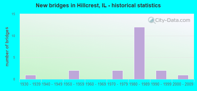
- New bridges - historical statistics
- 11930-1939
- 21950-1959
- 21970-1979
- 121980-1989
- 21990-1999
- 12000-2009


- Bridge Condition - Deck
- 12.5%Very good
- 50.0%Good
- 37.5%Satisfactory

- Bridge Condition - Superstructure
- 12.5%Very good
- 50.0%Good
- 25.0%Satisfactory
- 12.5%Fair

- Bridge Condition - Substructure
- 12.5%Very good
- 62.5%Good
- 25.0%Satisfactory

- Bridge Condition - Channel
- 28.6%Very good
- 35.7%Good
- 35.7%Satisfactory

- Bridge Condition - Culverts
- 22.2%Very good
- 33.3%Good
- 33.3%Satisfactory
- 11.1%Fair
Find on map >> Show street view
Structure Number: 710017, Location: .3 MI E OF I-39 (Lat: 42.007211, Lng: -89.014786), Route carried "on" structure: State highway 64, Year Built: 1936, Year Reconstructed: 1992, Status: Open, Structure Length: 4.81m (15.78ft), Average Daily Traffic: 4,200 (year 2021), Truck Traffic: 19%, Average Future Daily Traffic: 5,500 (year 2040), Design Load: HS 20, Features Intersected: KILBUCK CREEK
Minimum Vertical Clearance: 30+ m (98+ ft), Kilometerpoint: 104.444, Lanes on structure: 2, Base Highway Network: Yes, Owner: State Highway Agency, Approaching Roadway Width: 12.2m (40.0ft), Material/Design: Steel continuous, Design/Construction: Stringer/Multi-beam, Number Of Spans In Main Unit: 3, Length of Maximum Span: 19.4m (63.6ft), Curb-To-Curb Width: 12.2m (40.0ft), Out-to-Out Width: 13.2m (43.3ft)
Condition: Deck: Satisfactory, Superstructure: Satisfactory, Substructure: Satisfactory, Channel: Good, Operating Rating: 84.2 metric tons, Method Used To Determine Operating Rating: Load Factor (LF) rating reported by rating factor (RF) method using MS18 loading, Inventory Rating: 50.5 metric tons, Method Used To Determine Inventory Rating: Load Factor (LF) rating reported by rating factor (RF) method using MS18 loading, Structural Evaluation: Equal to present minimum criteria, Deck Geometry: Equal to present minimum criteria, Waterway Adequacy: Better than present minimum criteria, Approach Roadway Alignment: Equal to present desirable criteria, Designated Inspection Frequency: Every 24 months, Inspection Date: August 2021, Deck Structure Type: Concrete Cast-file-Place, Wearing Surface/Protective System: Deck Protection: Epoxy Coated Reinforcing
Find on map >> Show street view
Structure Number: 710054, Location: 1 MI N OF ILL 64 (Lat: 42.021650, Lng: -89.020719), Route carried "on" structure: County highway , Year Built: 1980, Status: Open, Structure Length: 7.86m (25.79ft), Average Daily Traffic: 50 (year 2017), Average Future Daily Traffic: 25 (year 2040), Design Load: HS 20+Mod, Features Intersected: I-39 & US 51, Facility Carried by Structure: MOWERS RD
Minimum Vertical Clearance: 30+ m (98+ ft), Kilometerpoint: 9.286, Lanes on structure: 2, Lanes under structure: 4, Owner: State Highway Agency, Approaching Roadway Width: 7.9m (25.9ft), Material/Design: Steel continuous, Design/Construction: Stringer/Multi-beam, Number Of Spans In Main Unit: 2, Number Of Approach Spans: 2, Length of Maximum Span: 32.3m (106.0ft), Curb-To-Curb Width: 8.2m (26.9ft), Out-to-Out Width: 9.1m (29.9ft)
Condition: Deck: Good, Superstructure: Good, Substructure: Good, Operating Rating: 53.5 metric tons, Method Used To Determine Operating Rating: Allowable Stress (AS) rating reported by rating factor (RF) method using MS18 loading, Inventory Rating: 33.0 metric tons, Method Used To Determine Inventory Rating: Allowable Stress (AS) rating reported by rating factor (RF) method using MS18 loading, Structural Evaluation: Better than present minimum criteria, Deck Geometry: Equal to present minimum criteria, Underclear: Somewhat better than minimum adequacy, Approach Roadway Alignment: Equal to present desirable criteria, Designated Inspection Frequency: Every 24 months, Inspection Date: Febuary 2021, Deck Structure Type: Concrete Cast-file-Place, Wearing Surface/Protective System: Wearing Surface: Bituminous, Membrane: Built-up
Find on map >> Show street view
Structure Number: 710055, Location: 4 MI. W OF DEKALB CO (Lat: 42.007111, Lng: -89.020619), Route carried "on" structure: State highway 64, Year Built: 1980, Status: Open, Structure Length: 8.11m (26.61ft), Average Daily Traffic: 4,300 (year 2021), Truck Traffic: 17%, Average Future Daily Traffic: 5,500 (year 2040), Design Load: HS 20, Features Intersected: I-39 & US 51
Minimum Vertical Clearance: 30+ m (98+ ft), Kilometerpoint: 103.913, Lanes on structure: 2, Lanes under structure: 4, Base Highway Network: Yes, Owner: State Highway Agency, Approaching Roadway Width: 20.1m (65.9ft), Skew: 30 degrees, Material/Design: Steel continuous, Design/Construction: Stringer/Multi-beam, Number Of Spans In Main Unit: 2, Number Of Approach Spans: 2, Length of Maximum Span: 34.4m (112.9ft), Curb-To-Curb Width: 14.5m (47.6ft), Out-to-Out Width: 20.7m (67.9ft)
Condition: Deck: Satisfactory, Superstructure: Satisfactory, Substructure: Satisfactory, Operating Rating: 68.0 metric tons, Method Used To Determine Operating Rating: Allowable Stress (AS) rating reported by rating factor (RF) method using MS18 loading, Inventory Rating: 38.9 metric tons, Method Used To Determine Inventory Rating: Allowable Stress (AS) rating reported by rating factor (RF) method using MS18 loading, Structural Evaluation: Equal to present minimum criteria, Deck Geometry: Superior to present desirable criteria, Underclear: Somewhat better than minimum adequacy, Approach Roadway Alignment: Equal to present desirable criteria, Designated Inspection Frequency: Every 24 months, Inspection Date: March 2021, Deck Structure Type: Concrete Cast-file-Place, Wearing Surface/Protective System: Wearing Surface: Other, Deck Protection: Epoxy Coated Reinforcing
Find on map >> Show street view
Structure Number: 710056, Location: 1 MI S OF ILL 64 (Lat: 41.985408, Lng: -89.020458), Route carried "on" structure: County highway , Year Built: 1980, Status: Open, Structure Length: 7.89m (25.89ft), Average Daily Traffic: 250 (year 2017), Average Future Daily Traffic: 150 (year 2040), Design Load: HS 20, Features Intersected: I-39 & US 51, Facility Carried by Structure: BETHEL RD
Minimum Vertical Clearance: 30+ m (98+ ft), Kilometerpoint: 7.676, Lanes on structure: 2, Lanes under structure: 4, Owner: State Highway Agency, Approaching Roadway Width: 6.1m (20.0ft), Material/Design: Steel continuous, Design/Construction: Stringer/Multi-beam, Number Of Spans In Main Unit: 2, Number Of Approach Spans: 2, Length of Maximum Span: 33.0m (108.3ft), Curb-To-Curb Width: 8.1m (26.6ft), Out-to-Out Width: 9.1m (29.9ft)
Condition: Deck: Good, Superstructure: Good, Substructure: Good, Operating Rating: 94.0 metric tons, Method Used To Determine Operating Rating: Load Factor (LF) rating reported by rating factor (RF) method using MS18 loading, Inventory Rating: 54.4 metric tons, Method Used To Determine Inventory Rating: Load Factor (LF) rating reported by rating factor (RF) method using MS18 loading, Structural Evaluation: Better than present minimum criteria, Deck Geometry: Somewhat better than minimum adequacy, Underclear: Somewhat better than minimum adequacy, Approach Roadway Alignment: Equal to present desirable criteria, Designated Inspection Frequency: Every 24 months, Inspection Date: November 2021, Deck Structure Type: Concrete Cast-file-Place, Wearing Surface/Protective System: Wearing Surface: Bituminous, Membrane: Built-up
Find on map >> Show street view
Structure Number: 71201, Location: 1.75 MI S OF IL 64 (Lat: 41.981364, Lng: -89.020431), Route carried "on" structure: Interstate 39, Year Built: 1981, Status: Open, Structure Length: 2.55m (8.37ft), Average Daily Traffic: 29,500 (year 2021), Truck Traffic: 34%, Average Future Daily Traffic: 49,900 (year 2040), Design Load: HS 20+Mod, Features Intersected: STREAM
Minimum Vertical Clearance: 30+ m (98+ ft), Kilometerpoint: 166.273, Lanes on structure: 4, Base Highway Network: Yes, Owner: State Highway Agency, Approaching Roadway Width: 26.8m (87.9ft), Skew: 16 degrees, Material/Design: Concrete, Design/Construction: Culvert, Number Of Spans In Main Unit: 3, Length of Maximum Span: 9.4m (30.8ft)
Condition: Channel: Good, Culverts: Satisfactory, Operating Rating: 55.4 metric tons, Method Used To Determine Operating Rating: Load Factor (LF) rating reported by rating factor (RF) method using MS18 loading, Inventory Rating: 33.4 metric tons, Method Used To Determine Inventory Rating: Load Factor (LF) rating reported by rating factor (RF) method using MS18 loading, Structural Evaluation: Equal to present minimum criteria, Waterway Adequacy: Equal to present desirable criteria, Approach Roadway Alignment: Equal to present desirable criteria, Designated Inspection Frequency: Every 24 months, Inspection Date: November 2021
Find on map >> Show street view
Structure Number: 712011, Location: 1.25 MI N OF IL 64 (Lat: 42.026725, Lng: -89.020756), Route carried "on" structure: Interstate 39, Year Built: 1981, Status: Open, Structure Length: 1.04m (3.41ft), Average Daily Traffic: 28,300 (year 2021), Truck Traffic: 34%, Average Future Daily Traffic: 48,700 (year 2040), Design Load: HS 20+Mod, Features Intersected: STREAM
Minimum Vertical Clearance: 30+ m (98+ ft), Kilometerpoint: 171.326, Lanes on structure: 4, Base Highway Network: Yes, Owner: State Highway Agency, Approaching Roadway Width: 24.4m (80.1ft), Skew: 14 degrees, Material/Design: Concrete, Design/Construction: Culvert, Number Of Spans In Main Unit: 2, Length of Maximum Span: 5.1m (16.7ft)
Condition: Channel: Satisfactory, Culverts: Good, Operating Rating: 57.7 metric tons, Method Used To Determine Operating Rating: Load Factor (LF) rating reported by rating factor (RF) method using MS18 loading, Inventory Rating: 34.3 metric tons, Method Used To Determine Inventory Rating: Load Factor (LF) rating reported by rating factor (RF) method using MS18 loading, Structural Evaluation: Better than present minimum criteria, Waterway Adequacy: Equal to present desirable criteria, Approach Roadway Alignment: Equal to present desirable criteria, Designated Inspection Frequency: Every 24 months, Inspection Date: November 2021
Find on map >> Show street view
Structure Number: 712014, Location: 1.93 MI N OF IL 38 (Lat: 41.963717, Lng: -89.023342), Route carried "on" structure: Interstate 39, Year Built: 1981, Status: Open, Structure Length: 0.67m (2.20ft), Average Daily Traffic: 29,500 (year 2021), Truck Traffic: 34%, Average Future Daily Traffic: 49,900 (year 2040), Design Load: HS 20+Mod, Features Intersected: STREAM
Minimum Vertical Clearance: 30+ m (98+ ft), Kilometerpoint: 164.293, Lanes on structure: 4, Base Highway Network: Yes, Owner: State Highway Agency, Approaching Roadway Width: 26.8m (87.9ft), Skew: 11 degrees, Material/Design: Concrete, Design/Construction: Culvert, Number Of Spans In Main Unit: 2, Length of Maximum Span: 3.2m (10.5ft)
Condition: Channel: Good, Culverts: Fair, Operating Rating: 97.2 metric tons, Method Used To Determine Operating Rating: Load Factor (LF) rating reported by rating factor (RF) method using MS18 loading, Inventory Rating: 97.2 metric tons, Method Used To Determine Inventory Rating: Load Factor (LF) rating reported by rating factor (RF) method using MS18 loading, Structural Evaluation: Somewhat better than minimum adequacy, Waterway Adequacy: Equal to present desirable criteria, Approach Roadway Alignment: Equal to present desirable criteria, Designated Inspection Frequency: Every 24 months, Inspection Date: September 2020
Find on map >> Show street view
Structure Number: 712021, Location: 2 MI. N. OF IL 64 (Lat: 42.035103, Lng: -89.065850), Route carried "on" structure: State highway 251, Year Built: 1991, Status: Open, Structure Length: 0.73m (2.40ft), Average Daily Traffic: 3,950 (year 2021), Truck Traffic: 10%, Average Future Daily Traffic: 3,800 (year 2040), Design Load: HS 20+Mod, Features Intersected: UNNAMED STREAM
Minimum Vertical Clearance: 30+ m (98+ ft), Kilometerpoint: 162.234, Lanes on structure: 2, Base Highway Network: Yes, Owner: State Highway Agency, Approaching Roadway Width: 7.9m (25.9ft), Material/Design: Concrete continuous, Design/Construction: Culvert, Number Of Spans In Main Unit: 2, Length of Maximum Span: 3.6m (11.8ft)
Condition: Channel: Satisfactory, Culverts: Good, Operating Rating: 65.8 metric tons, Method Used To Determine Operating Rating: Load Factor (LF) rating reported by rating factor (RF) method using MS18 loading, Inventory Rating: 39.5 metric tons, Method Used To Determine Inventory Rating: Load Factor (LF) rating reported by rating factor (RF) method using MS18 loading, Structural Evaluation: Better than present minimum criteria, Waterway Adequacy: Equal to present desirable criteria, Approach Roadway Alignment: Equal to present desirable criteria, Designated Inspection Frequency: Every 48 months, Inspection Date: December 2021
Find on map >> Show street view
Structure Number: 713234, Location: 5.0 S LINDENWOOD (Lat: 41.985442, Lng: -89.017281), Route carried "on" structure: County highway , Year Built: 1978, Status: Open, Structure Length: 2.26m (7.41ft), Average Daily Traffic: 250 (year 2017), Average Future Daily Traffic: 75 (year 2040), Design Load: HS 20, Features Intersected: BR.KILBUCK CREEK, Facility Carried by Structure: BETHEL ROAD
Minimum Vertical Clearance: 30+ m (98+ ft), Kilometerpoint: 7.950, Lanes on structure: 2, Owner: Town or Township Highway Agency, Approaching Roadway Width: 8.5m (27.9ft), Skew: 1 degrees, Material/Design: Concrete, Design/Construction: Channel Beam, Number Of Spans In Main Unit: 3, Length of Maximum Span: 7.3m (24.0ft), Curb-To-Curb Width: 7.3m (24.0ft), Out-to-Out Width: 8.1m (26.6ft)
Condition: Deck: Very good, Superstructure: Very good, Substructure: Good, Channel: Good, Operating Rating: 44.4 metric tons, Method Used To Determine Operating Rating: Assigned rating based on Load Factor Design (LFD) reported by rating factor (RF) using MS18 loading, Inventory Rating: 32.4 metric tons, Method Used To Determine Inventory Rating: Assigned rating based on Load Factor Design (LFD) reported by rating factor (RF) using MS18 loading, Structural Evaluation: Better than present minimum criteria, Deck Geometry: Somewhat better than minimum adequacy, Waterway Adequacy: Equal to present desirable criteria, Approach Roadway Alignment: Equal to present desirable criteria, Designated Inspection Frequency: Every 48 months, Inspection Date: July 2021, Deck Structure Type: Concrete Precast Panels
Find on map >> Show street view
Structure Number: 713243, Location: 2.5 MI N ROCHELLE (Lat: 41.962808, Lng: -89.077919), Route carried "on" structure: County highway , Year Built: 1980, Status: Open, Structure Length: 1.22m (4.00ft), Average Daily Traffic: 700 (year 2017), Truck Traffic: 6%, Average Future Daily Traffic: 1,200 (year 2040), Design Load: HS 20, Features Intersected: UNNAMED STREAM, Facility Carried by Structure: HEMSTOCK ROAD
Minimum Vertical Clearance: 30+ m (98+ ft), Kilometerpoint: 7.338, Lanes on structure: 2, Owner: City or Municipal Highway Agency, Approaching Roadway Width: 8.5m (27.9ft), Material/Design: Concrete, Design/Construction: Channel Beam, Number Of Spans In Main Unit: 1, Length of Maximum Span: 11.3m (37.1ft), Curb-To-Curb Width: 7.9m (25.9ft), Out-to-Out Width: 8.0m (26.2ft)
Condition: Deck: Satisfactory, Superstructure: Fair, Substructure: Good, Channel: Very good, Operating Rating: 52.2 metric tons, Method Used To Determine Operating Rating: Load Factor (LF) rating reported by rating factor (RF) method using MS18 loading, Inventory Rating: 31.4 metric tons, Method Used To Determine Inventory Rating: Load Factor (LF) rating reported by rating factor (RF) method using MS18 loading, Structural Evaluation: Somewhat better than minimum adequacy, Deck Geometry: Somewhat better than minimum adequacy, Waterway Adequacy: Better than present minimum criteria, Approach Roadway Alignment: Equal to present desirable criteria, Designated Inspection Frequency: Every 24 months, Inspection Date: July 2021, Deck Structure Type: Concrete Precast Panels, Wearing Surface/Protective System: Wearing Surface: Bituminous, Membrane: Built-up
Find on map >> Show street view
Structure Number: 71325, Location: 3.0 MI SE LINDENWOOD (Lat: 42.021739, Lng: -89.003936), Route carried "on" structure: County highway , Year Built: 1983, Status: Open, Structure Length: 2.26m (7.41ft), Average Daily Traffic: 50 (year 2017), Average Future Daily Traffic: 25 (year 2040), Design Load: HS 20, Features Intersected: KILBUCK CREEK, Facility Carried by Structure: MOWERS RD
Minimum Vertical Clearance: 30+ m (98+ ft), Kilometerpoint: 10.750, Lanes on structure: 2, Owner: Town or Township Highway Agency, Approaching Roadway Width: 7.3m (24.0ft), Material/Design: Prestressed concrete, Design/Construction: Box Beam or Girders - Multiple, Number Of Spans In Main Unit: 1, Length of Maximum Span: 21.9m (71.9ft), Curb-To-Curb Width: 7.3m (24.0ft), Out-to-Out Width: 7.3m (24.0ft)
Condition: Deck: Good, Superstructure: Good, Substructure: Good, Channel: Very good, Operating Rating: 44.4 metric tons, Method Used To Determine Operating Rating: Assigned rating based on Load Factor Design (LFD) reported by rating factor (RF) using MS18 loading, Inventory Rating: 32.4 metric tons, Method Used To Determine Inventory Rating: Assigned rating based on Load Factor Design (LFD) reported by rating factor (RF) using MS18 loading, Structural Evaluation: Better than present minimum criteria, Deck Geometry: Equal to present minimum criteria, Waterway Adequacy: Equal to present desirable criteria, Approach Roadway Alignment: Equal to present minimum criteria, Designated Inspection Frequency: Every 48 months, Inspection Date: July 2021, Deck Structure Type: Concrete Precast Panels
Find on map >> Show street view
Structure Number: 713258, Location: 4.5 M NW CRESTON (Lat: 41.989692, Lng: -89.000503), Route carried "on" structure: County highway , Year Built: 1981, Status: Open, Structure Length: 1.92m (6.30ft), Average Daily Traffic: 750 (year 2017), Truck Traffic: 23%, Average Future Daily Traffic: 950 (year 2040), Design Load: HS 20, Features Intersected: KILBUCK CREEK, Facility Carried by Structure: MULFORD ROAD
Minimum Vertical Clearance: 30+ m (98+ ft), Kilometerpoint: 1.963, Lanes on structure: 2, Owner: Town or Township Highway Agency, Approaching Roadway Width: 8.5m (27.9ft), Skew: 2 degrees, Material/Design: Prestressed concrete, Design/Construction: Box Beam or Girders - Multiple, Number Of Spans In Main Unit: 1, Length of Maximum Span: 18.3m (60.0ft), Curb-To-Curb Width: 8.5m (27.9ft), Out-to-Out Width: 8.5m (27.9ft)
Condition: Deck: Good, Superstructure: Good, Substructure: Very good, Channel: Very good, Operating Rating: 44.4 metric tons, Method Used To Determine Operating Rating: Assigned rating based on Load Factor Design (LFD) reported by rating factor (RF) using MS18 loading, Inventory Rating: 32.4 metric tons, Method Used To Determine Inventory Rating: Assigned rating based on Load Factor Design (LFD) reported by rating factor (RF) using MS18 loading, Structural Evaluation: Better than present minimum criteria, Deck Geometry: Somewhat better than minimum adequacy, Waterway Adequacy: Equal to present desirable criteria, Approach Roadway Alignment: Equal to present desirable criteria, Designated Inspection Frequency: Every 48 months, Inspection Date: July 2021, Deck Structure Type: Concrete Precast Panels
Find on map >> Show street view
Structure Number: 715007, Location: 7.0 MI NE HILLCREST (Lat: 42.026636, Lng: -89.030081), Route carried "on" structure: County highway , Year Built: 1958, Status: Open, Structure Length: 0.98m (3.22ft), Average Daily Traffic: 525 (year 2017), Truck Traffic: 13%, Average Future Daily Traffic: 700 (year 2040), Design Load: HS 15, Features Intersected: BRANCH KILLBUCK CR, Facility Carried by Structure: LYNNVILLE RD
Minimum Vertical Clearance: 30+ m (98+ ft), Kilometerpoint: 3.605, Lanes on structure: 2, Owner: County Highway Agency, Approaching Roadway Width: 11.0m (36.1ft), Material/Design: Concrete, Design/Construction: Culvert, Number Of Spans In Main Unit: 3, Length of Maximum Span: 3.0m (9.8ft)
Condition: Channel: Satisfactory, Culverts: Good, Operating Rating: 36.0 metric tons, Method Used To Determine Operating Rating: Load Factor (LF) rating reported by rating factor (RF) method using MS18 loading, Inventory Rating: 21.4 metric tons, Method Used To Determine Inventory Rating: Load Factor (LF) rating reported by rating factor (RF) method using MS18 loading, Structural Evaluation: Somewhat better than minimum adequacy, Waterway Adequacy: Superior to present desirable criteria, Approach Roadway Alignment: Equal to present desirable criteria, Designated Inspection Frequency: Every 24 months, Inspection Date: July 2021
Find on map >> Show street view
Structure Number: 715032, Location: 3.5 N.W. ROCHELLE (Lat: 41.984706, Lng: -89.083122), Route carried "on" structure: County highway , Year Built: 1956, Status: Open, Structure Length: 0.78m (2.56ft), Average Daily Traffic: 350 (year 2017), Truck Traffic: 15%, Average Future Daily Traffic: 350 (year 2040), Features Intersected: DRAINAGE DITCH, Facility Carried by Structure: BETHEL RD.
Minimum Vertical Clearance: 30+ m (98+ ft), Kilometerpoint: 2.543, Lanes on structure: 2, Owner: City or Municipal Highway Agency, Approaching Roadway Width: 8.5m (27.9ft), Material/Design: Concrete, Design/Construction: Culvert, Number Of Spans In Main Unit: 2, Length of Maximum Span: 3.7m (12.1ft), Curb-To-Curb Width: 8.5m (27.9ft), Out-to-Out Width: 8.9m (29.2ft)
Condition: Channel: Good, Culverts: Satisfactory, Operating Rating: 40.5 metric tons, Method Used To Determine Operating Rating: Field evaluation and documented engineering judgment, Inventory Rating: 24.3 metric tons, Method Used To Determine Inventory Rating: Field evaluation and documented engineering judgment, Structural Evaluation: Equal to present minimum criteria, Deck Geometry: Equal to present minimum criteria, Waterway Adequacy: Equal to present desirable criteria, Approach Roadway Alignment: Equal to present desirable criteria, Designated Inspection Frequency: Every 24 months, Inspection Date: July 2021
Find on map >> Show street view
Structure Number: 715067, Location: .6 MI E LYNNVILLE RD (Lat: 42.021692, Lng: -89.016828), Route carried "on" structure: County highway , Year Built: 1976, Status: Open, Structure Length: 0.67m (2.20ft), Average Daily Traffic: 50 (year 2017), Average Future Daily Traffic: 25 (year 2040), Design Load: HS 20, Features Intersected: BR KILBUCK CREEK, Facility Carried by Structure: MOWERS RD
Minimum Vertical Clearance: 30+ m (98+ ft), Kilometerpoint: 9.624, Lanes on structure: 2, Owner: Town or Township Highway Agency, Approaching Roadway Width: 7.3m (24.0ft), Material/Design: Concrete, Design/Construction: Culvert, Number Of Spans In Main Unit: 2, Length of Maximum Span: 3.0m (9.8ft), Curb-To-Curb Width: 9.6m (31.5ft), Out-to-Out Width: 9.6m (31.5ft)
Condition: Channel: Satisfactory, Culverts: Satisfactory, Operating Rating: 44.4 metric tons, Method Used To Determine Operating Rating: Assigned rating based on Load Factor Design (LFD) reported by rating factor (RF) using MS18 loading, Inventory Rating: 32.4 metric tons, Method Used To Determine Inventory Rating: Assigned rating based on Load Factor Design (LFD) reported by rating factor (RF) using MS18 loading, Structural Evaluation: Equal to present minimum criteria, Deck Geometry: Better than present minimum criteria, Waterway Adequacy: Equal to present desirable criteria, Approach Roadway Alignment: Equal to present desirable criteria, Designated Inspection Frequency: Every 24 months, Inspection Date: July 2021
Find on map >> Show street view
Structure Number: 715108, Location: 4 MI. N. OF ROCHELLE (Lat: 41.985844, Lng: -89.084692), Route carried "on" structure: County highway , Year Built: 1999, Status: Open, Structure Length: 0.92m (3.02ft), Average Daily Traffic: 25 (year 2017), Average Future Daily Traffic: 25 (year 2040), Design Load: HS 20, Features Intersected: DRAINAGE DITCH, Facility Carried by Structure: KENT RD
Minimum Vertical Clearance: 30+ m (98+ ft), Kilometerpoint: 2.301, Lanes on structure: 2, Owner: Town or Township Highway Agency, Approaching Roadway Width: 7.9m (25.9ft), Material/Design: Concrete, Design/Construction: Culvert, Number Of Spans In Main Unit: 2, Length of Maximum Span: 4.3m (14.1ft)
Condition: Channel: Very good, Culverts: Very good, Operating Rating: 44.1 metric tons, Method Used To Determine Operating Rating: Assigned rating based on Load Factor Design (LFD) reported by rating factor (RF) using MS18 loading, Inventory Rating: 32.4 metric tons, Method Used To Determine Inventory Rating: Assigned rating based on Load Factor Design (LFD) reported by rating factor (RF) using MS18 loading, Structural Evaluation: Equal to present desirable criteria, Waterway Adequacy: Superior to present desirable criteria, Approach Roadway Alignment: Superior to present desirable criteria, Designated Inspection Frequency: Every 48 months, Inspection Date: July 2021
Find on map >> Show street view
Structure Number: 715111, Location: 2.0 MI SW LINDENWOOD (Lat: 42.031144, Lng: -89.039869), Route carried "on" structure: County highway , Year Built: 2000, Status: Open, Structure Length: 0.96m (3.15ft), Average Daily Traffic: 50 (year 2017), Average Future Daily Traffic: 10 (year 2040), Design Load: HS 20, Features Intersected: BR KILLBUCK CREEK, Facility Carried by Structure: MOORE RD
Minimum Vertical Clearance: 30+ m (98+ ft), Kilometerpoint: 1.336, Lanes on structure: 2, Owner: Town or Township Highway Agency, Approaching Roadway Width: 9.1m (29.9ft), Material/Design: Concrete, Design/Construction: Culvert, Number Of Spans In Main Unit: 3, Length of Maximum Span: 3.0m (9.8ft)
Condition: Channel: Satisfactory, Culverts: Very good, Operating Rating: 44.1 metric tons, Method Used To Determine Operating Rating: Assigned rating based on Load Factor Design (LFD) reported by rating factor (RF) using MS18 loading, Inventory Rating: 32.4 metric tons, Method Used To Determine Inventory Rating: Assigned rating based on Load Factor Design (LFD) reported by rating factor (RF) using MS18 loading, Structural Evaluation: Equal to present desirable criteria, Waterway Adequacy: Superior to present desirable criteria, Approach Roadway Alignment: Equal to present desirable criteria, Designated Inspection Frequency: Every 48 months, Inspection Date: July 2021
Find on map >> Show street view
Structure Number: 710054, Location: 1 MI N OF ILL 64 (Lat: 42.021794, Lng: -89.020722), Route carried "under" structure: Interstate 39, Year Built: 1980, Structure Length: 0. m, Average Daily Traffic: 28,300 (year 2021), Truck Traffic: 34%, Features Intersected: I-39 & US 51, Facility Carried by Structure: MOWERS RD
Minimum Vertical Clearance: 5.05m (16.57ft), Kilometerpoint: 170.779, Lanes on structure: 2, Lanes under structure: 4, Material/Design: Steel continuous, Design/Construction: Stringer/Multi-beam, Length of Maximum Span: 32.3m (106.0ft)
Find on map >> Show street view
Structure Number: 710055, Location: 4 MI. W OF DEKALB CO (Lat: 42.007400, Lng: -89.020622), Route carried "under" structure: Interstate 39, Year Built: 1980, Structure Length: 0. m, Average Daily Traffic: 28,300 (year 2021), Truck Traffic: 34%, Features Intersected: I-39 & US 51, Facility Carried by Structure: ILL 64
Minimum Vertical Clearance: 5.38m (17.65ft), Kilometerpoint: 169.170, Lanes on structure: 2, Lanes under structure: 4, Material/Design: Steel continuous, Design/Construction: Stringer/Multi-beam, Length of Maximum Span: 34.4m (112.9ft)
Find on map >> Show street view
Structure Number: 710056, Location: 1 MI S OF ILL 64 (Lat: 41.985739, Lng: -89.020461), Route carried "under" structure: Interstate 39, Year Built: 1980, Structure Length: 0. m, Average Daily Traffic: 29,500 (year 2021), Truck Traffic: 34%, Features Intersected: I-39 & US 51, Facility Carried by Structure: BETHEL RD
Minimum Vertical Clearance: 5.31m (17.42ft), Kilometerpoint: 166.756, Lanes on structure: 2, Lanes under structure: 4, Material/Design: Steel continuous, Design/Construction: Stringer/Multi-beam, Length of Maximum Span: 33.0m (108.3ft)