Bridge Statistics for Highspire, Pennsylvania (PA)
Condition, Traffic, Stress, Structural Evaluation, Project Costs
- National Bridge Inventory (NBI) Statistics
- 33Number of bridges
- 164ft / 49.7mTotal length
- $12,755,000Total costs
- 473,824Total average daily traffic
- 76,269Total average daily truck traffic
- National Bridge Inventory (NBI) Registered Bridges for Highspire
- No street view available for this location
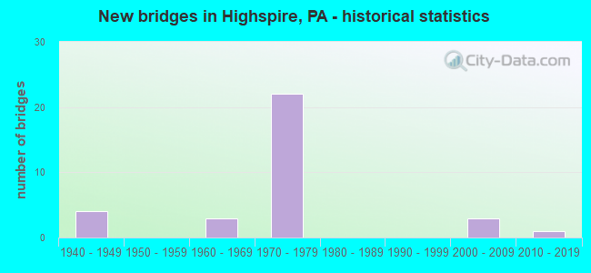
- New bridges - historical statistics
- 41940-1949
- 31960-1969
- 221970-1979
- 32000-2009
- 12010-2019

- Reconstructed bridges - Historical Statistics
- 32000-2009
- 32010-2019
- 12020-2022


- Bridge Condition - Deck
- 33.3%Very good
- 58.3%Good
- 8.3%Satisfactory

- Bridge Condition - Superstructure
- 8.3%Excellent
- 25.0%Very good
- 33.3%Good
- 16.7%Satisfactory
- 16.7%Fair

- Bridge Condition - Substructure
- 8.3%Very good
- 50.0%Good
- 33.3%Satisfactory
- 8.3%Fair

- Bridge Condition - Channel
- 33.3%Good
- 33.3%Satisfactory
- 33.3%Fair
Find on map >> Show street view
Structure Number: 14346, Location: 1 MI N HIGHSPIRE (Lat: 40.219281, Lng: -76.787803), Route carried "on" structure: State highway 283, Year Built: 1969, Year Reconstructed: 2020, Status: Open, Structure Length: 4.48m (14.70ft), Average Daily Traffic: 51,662 (year 2021), Truck Traffic: 17%, Average Future Daily Traffic: 70,289 (year 2032), Design Load: HL 93, Features Intersected: I-283; SR 0283
Minimum Vertical Clearance: 30+ m (98+ ft), Kilometerpoint: 0.000, Lanes on structure: 6, Lanes under structure: 12, Base Highway Network: Yes, Owner: State Highway Agency, Approaching Roadway Width: 28.7m (94.2ft), Skew: 22 degrees, Material/Design: Prestressed concrete, Design/Construction: Box Beam or Girders - Single/Spread, Number Of Spans In Main Unit: 2, Length of Maximum Span: 22.3m (73.2ft), Curb or Sidewalk Widths: Left: 0.1m (0.3ft), Right: 0.1m (0.3ft), Curb-To-Curb Width: 25.6m (84.0ft), Out-to-Out Width: 27.6m (90.6ft)
Condition: Deck: Very good, Superstructure: Good, Substructure: Good, Operating Rating: 50.9 metric tons, Method Used To Determine Operating Rating: Assigned ratings based on Load and Resistance Factor Design (LRFD) reported by rating factor (RF) using HL93 loadings, Inventory Rating: 39.2 metric tons, Method Used To Determine Inventory Rating: Assigned ratings based on Load and Resistance Factor Design (LRFD) reported by rating factor (RF) using HL93 loadings, Structural Evaluation: Better than present minimum criteria, Deck Geometry: Meets minimum limits, Underclear: Equal to present minimum criteria, Approach Roadway Alignment: Equal to present desirable criteria, Length Of Structure Improvement: 5.50m (18.04ft), Designated Inspection Frequency: Every 24 months, Inspection Date: August 2020, Bridge Improvement Cost: $410,000, Roadway Improvement Cost: $1,208,000, Total Project Cost: $5,537,000, Deck Structure Type: Concrete Cast-file-Place, Wearing Surface/Protective System: Wearing Surface: Monolithic Concrete, Deck Protection: Epoxy Coated Reinforcing
Find on map >> Show street view
Structure Number: 14347, Location: 1 mi. North of Highspire (Lat: 40.221919, Lng: -76.783553), Route carried "on" structure: State highway 283, Year Built: 1971, Year Reconstructed: 2019, Status: Open, Structure Length: 4.69m (15.39ft), Average Daily Traffic: 51,662 (year 2021), Truck Traffic: 17%, Average Future Daily Traffic: 70,289 (year 2032), Design Load: HL 93, Features Intersected: Turnpike Industrial Dr.
Minimum Vertical Clearance: 30+ m (98+ ft), Kilometerpoint: 0.748, Lanes on structure: 6, Lanes under structure: 2, Base Highway Network: Yes, Owner: State Highway Agency, Approaching Roadway Width: 35.1m (115.2ft), Skew: 32 degrees, Material/Design: Prestressed concrete, Design/Construction: Box Beam or Girders - Single/Spread, Number Of Spans In Main Unit: 3, Length of Maximum Span: 22.9m (75.1ft), Curb or Sidewalk Widths: Left: 0.2m (0.7ft), Right: 0.2m (0.7ft), Curb-To-Curb Width: 34.9m (114.5ft), Out-to-Out Width: 36.1m (118.4ft)
Condition: Deck: Very good, Superstructure: Good, Substructure: Good, Operating Rating: 43.5 metric tons, Method Used To Determine Operating Rating: Assigned ratings based on Load and Resistance Factor Design (LRFD) reported in metric tons, Inventory Rating: 33.6 metric tons, Method Used To Determine Inventory Rating: Assigned ratings based on Load and Resistance Factor Design (LRFD) reported in metric tons, Structural Evaluation: Better than present minimum criteria, Deck Geometry: Superior to present desirable criteria, Underclear: Equal to present minimum criteria, Approach Roadway Alignment: Equal to present desirable criteria, Length Of Structure Improvement: 5.50m (18.04ft), Designated Inspection Frequency: Every 24 months, Inspection Date: September 2020, Bridge Improvement Cost: $274,000, Roadway Improvement Cost: $807,000, Total Project Cost: $3,699,000, Deck Structure Type: Concrete Cast-file-Place, Wearing Surface/Protective System: Wearing Surface: Monolithic Concrete, Deck Protection: Epoxy Coated Reinforcing
Find on map >> Show street view
Structure Number: 14348, Location: 1.5 MI. N. HIGHSPIRE (Lat: 40.223414, Lng: -76.777008), Route carried "on" structure: State highway 283, Year Built: 1971, Year Reconstructed: 2019, Status: Open, Structure Length: 2.10m (6.89ft), Average Daily Traffic: 25,119 (year 2021), Truck Traffic: 17%, Average Future Daily Traffic: 34,626 (year 2032), Design Load: HL 93, Features Intersected: Lumber St. (T-380)
Minimum Vertical Clearance: 30+ m (98+ ft), Kilometerpoint: 1.347, Lanes on structure: 2, Lanes under structure: 2, Base Highway Network: Yes, Owner: State Highway Agency, Approaching Roadway Width: 11.6m (38.1ft), Skew: 11 degrees, Material/Design: Prestressed concrete, Design/Construction: Box Beam or Girders - Single/Spread, Number Of Spans In Main Unit: 1, Length of Maximum Span: 21.0m (68.9ft), Curb or Sidewalk Widths: Left: 0.2m (0.7ft), Right: 0.2m (0.7ft), Curb-To-Curb Width: 12.2m (40.0ft), Out-to-Out Width: 13.4m (44.0ft)
Condition: Deck: Good, Superstructure: Very good, Substructure: Satisfactory, Operating Rating: 51.7 metric tons, Method Used To Determine Operating Rating: Assigned ratings based on Load and Resistance Factor Design (LRFD) reported in metric tons, Inventory Rating: 29.0 metric tons, Method Used To Determine Inventory Rating: Assigned ratings based on Load and Resistance Factor Design (LRFD) reported in metric tons, Structural Evaluation: Equal to present minimum criteria, Deck Geometry: Better than present minimum criteria, Underclear: Equal to present minimum criteria, Approach Roadway Alignment: Equal to present desirable criteria, Length Of Structure Improvement: 2.80m (9.19ft), Designated Inspection Frequency: Every 24 months, Inspection Date: September 2020, Deck Structure Type: Concrete Cast-file-Place, Wearing Surface/Protective System: Wearing Surface: Monolithic Concrete
Find on map >> Show street view
Structure Number: 14349, Location: 1.5 MI.N. OF HIGHSPIRE (Lat: 40.223717, Lng: -76.776408), Route carried "on" structure: State highway 283, Year Built: 1971, Year Reconstructed: 2018, Status: Open, Structure Length: 2.13m (6.99ft), Average Daily Traffic: 26,543 (year 2021), Truck Traffic: 17%, Average Future Daily Traffic: 35,663 (year 2032), Design Load: HS 20, Features Intersected: Lumber St. (T-380)
Minimum Vertical Clearance: 30+ m (98+ ft), Kilometerpoint: 1.357, Lanes on structure: 2, Lanes under structure: 2, Base Highway Network: Yes, Owner: State Highway Agency, Approaching Roadway Width: 11.6m (38.1ft), Skew: 11 degrees, Material/Design: Prestressed concrete, Design/Construction: Box Beam or Girders - Single/Spread, Number Of Spans In Main Unit: 1, Length of Maximum Span: 21.0m (68.9ft), Curb or Sidewalk Widths: Left: 0.2m (0.7ft), Right: 0.2m (0.7ft), Curb-To-Curb Width: 12.4m (40.7ft), Out-to-Out Width: 13.4m (44.0ft)
Condition: Deck: Very good, Superstructure: Good, Substructure: Good, Operating Rating: 65.3 metric tons, Method Used To Determine Operating Rating: Load Factor (LF), Inventory Rating: 27.2 metric tons, Method Used To Determine Inventory Rating: Load Factor (LF), Structural Evaluation: Equal to present minimum criteria, Deck Geometry: Better than present minimum criteria, Underclear: Equal to present minimum criteria, Approach Roadway Alignment: Equal to present desirable criteria, Length Of Structure Improvement: 2.80m (9.19ft), Designated Inspection Frequency: Every 24 months, Inspection Date: September 2020, Deck Structure Type: Concrete Cast-file-Place, Wearing Surface/Protective System: Wearing Surface: Monolithic Concrete, Deck Protection: Epoxy Coated Reinforcing
Find on map >> Show street view
Structure Number: 14563, Location: 1.0 MI. N.E. OF HIGHSPIRE (Lat: 40.203728, Lng: -76.757811), Route carried "on" structure: State highway , Year Built: 1976, Status: Open, Structure Length: 8.23m (27.00ft), Average Daily Traffic: 1,722 (year 2022), Truck Traffic: 3%, Average Future Daily Traffic: 2,067 (year 2032), Design Load: HS 20, Features Intersected: SR 3032, Facility Carried by Structure: TWP RD 382
Minimum Vertical Clearance: 30+ m (98+ ft), Kilometerpoint: 0.000, Lanes on structure: 2, Lanes under structure: 8, Owner: State Highway Agency, Approaching Roadway Width: 8.5m (27.9ft), Skew: 1 degrees, Material/Design: Steel, Design/Construction: Stringer/Multi-beam, Number Of Spans In Main Unit: 1, Number Of Approach Spans: 2, Length of Maximum Span: 53.3m (174.9ft), Curb or Sidewalk Widths: Left: 0.2m (0.7ft), Right: 1.8m (5.9ft), Curb-To-Curb Width: 8.5m (27.9ft), Out-to-Out Width: 11.6m (38.1ft)
Condition: Deck: Good, Superstructure: Fair, Substructure: Satisfactory, Operating Rating: 68.9 metric tons, Method Used To Determine Operating Rating: Load Factor (LF), Inventory Rating: 40.8 metric tons, Method Used To Determine Inventory Rating: Load Factor (LF), Structural Evaluation: Somewhat better than minimum adequacy, Deck Geometry: Somewhat better than minimum adequacy, Underclear: Somewhat better than minimum adequacy, Approach Roadway Alignment: Equal to present desirable criteria, Length Of Structure Improvement: 9.20m (30.18ft), Designated Inspection Frequency: Every 24 months, Inspection Date: September 2020, Deck Structure Type: Concrete Cast-file-Place, Wearing Surface/Protective System: Wearing Surface: Monolithic Concrete, Deck Protection: Galvanized Reinforcing
Find on map >> Show street view
Structure Number: 14565, Location: 1.5 MI. N.E. OF HIGHSPIRE (Lat: 40.218939, Lng: -76.754969), Route carried "on" structure: Spur State highway , Year Built: 1976, Year Reconstructed: 2007, Status: Open, Structure Length: 3.81m (12.50ft), Average Daily Traffic: 13,986 (year 2021), Truck Traffic: 7%, Average Future Daily Traffic: 16,257 (year 2032), Design Load: HS 20, Features Intersected: TWP RD 333, Facility Carried by Structure: SR 3032 AIRPORT CN
Minimum Vertical Clearance: 30+ m (98+ ft), Kilometerpoint: 2.311, Lanes on structure: 4, Lanes under structure: 2, Base Highway Network: Yes, Owner: State Highway Agency, Approaching Roadway Width: 28.0m (91.9ft), Skew: 32 degrees, Material/Design: Prestressed concrete, Design/Construction: Box Beam or Girders - Single/Spread, Number Of Spans In Main Unit: 3, Length of Maximum Span: 17.1m (56.1ft), Curb or Sidewalk Widths: Left: 0.2m (0.7ft), Right: 0.2m (0.7ft), Curb-To-Curb Width: 28.0m (91.9ft), Out-to-Out Width: 29.1m (95.5ft)
Condition: Deck: Good, Superstructure: Satisfactory, Substructure: Satisfactory, Operating Rating: 68.9 metric tons, Method Used To Determine Operating Rating: Load Factor (LF), Inventory Rating: 38.1 metric tons, Method Used To Determine Inventory Rating: Load Factor (LF), Structural Evaluation: Equal to present minimum criteria, Deck Geometry: Superior to present desirable criteria, Underclear: Equal to present minimum criteria, Approach Roadway Alignment: Equal to present desirable criteria, Length Of Structure Improvement: 4.70m (15.42ft), Designated Inspection Frequency: Every 24 months, Inspection Date: September 2020, Bridge Improvement Cost: $102,000, Roadway Improvement Cost: $301,000, Total Project Cost: $1,380,000, Deck Structure Type: Concrete Cast-file-Place, Wearing Surface/Protective System: Wearing Surface: Latex Concrete, Deck Protection: Galvanized Reinforcing
Find on map >> Show street view
Structure Number: 14567, Location: 2 MI. N.E. HIGHSPIRE (Lat: 40.225483, Lng: -76.757503), Route carried "on" structure: Spur State highway , Year Built: 1971, Year Reconstructed: 2006, Status: Open, Structure Length: 7.71m (25.30ft), Average Daily Traffic: 13,986 (year 2021), Truck Traffic: 7%, Average Future Daily Traffic: 16,257 (year 2032), Design Load: HS 20, Features Intersected: PA 283; SR 0300, Facility Carried by Structure: SR 3032 OBERLIN RD
Minimum Vertical Clearance: 30+ m (98+ ft), Kilometerpoint: 3.045, Lanes on structure: 2, Lanes under structure: 8, Base Highway Network: Yes, Owner: State Highway Agency, Approaching Roadway Width: 21.9m (71.9ft), Skew: 30 degrees, Material/Design: Prestressed concrete, Design/Construction: Box Beam or Girders - Single/Spread, Number Of Spans In Main Unit: 4, Length of Maximum Span: 26.5m (86.9ft), Curb or Sidewalk Widths: Left: 0.2m (0.7ft), Right: 0.2m (0.7ft), Curb-To-Curb Width: 7.9m (25.9ft), Out-to-Out Width: 15.1m (49.5ft)
Condition: Deck: Good, Superstructure: Fair, Substructure: Fair, Operating Rating: 52.6 metric tons, Method Used To Determine Operating Rating: Load Factor (LF), Inventory Rating: 30.8 metric tons, Method Used To Determine Inventory Rating: Load Factor (LF), Structural Evaluation: Somewhat better than minimum adequacy, Deck Geometry: High priority of corrective action, Underclear: Better than present minimum criteria, Approach Roadway Alignment: Equal to present desirable criteria, Length Of Structure Improvement: 8.60m (28.22ft), Designated Inspection Frequency: Every 24 months, Inspection Date: September 2020, Bridge Improvement Cost: $151,000, Roadway Improvement Cost: $444,000, Total Project Cost: $2,036,000, Deck Structure Type: Concrete Cast-file-Place, Wearing Surface/Protective System: Wearing Surface: Latex Concrete
Find on map >> Show street view
Structure Number: 14607, Location: HIGHSPIRE BORO (Lat: 40.208333, Lng: -76.786667), Route carried "on" structure: Interstate 76, Year Built: 1949, Year Reconstructed: 2007, Status: Open, Structure Length: 0.79m (2.59ft), Average Daily Traffic: 29,356 (year 2001), Truck Traffic: 21%, Average Future Daily Traffic: 39,064 (year 2030), Design Load: HS 20, Features Intersected: LAUREL RUN
Minimum Vertical Clearance: 30+ m (98+ ft), Kilometerpoint: 0.000, Lanes on structure: 6, Base Highway Network: Yes, Toll: On toll road, Owner: State Toll Authority, Approaching Roadway Width: 18.0m (59.1ft), Skew: 30 degrees, Material/Design: Concrete, Design/Construction: Culvert, Number Of Spans In Main Unit: 1, Length of Maximum Span: 6.1m (20.0ft)
Condition: Channel: Satisfactory, Culverts: Satisfactory, Operating Rating: 89.8 metric tons, Method Used To Determine Operating Rating: Load Factor (LF), Inventory Rating: 89.8 metric tons, Method Used To Determine Inventory Rating: Load Factor (LF), Structural Evaluation: Equal to present minimum criteria, Waterway Adequacy: Superior to present desirable criteria, Approach Roadway Alignment: Equal to present desirable criteria, Length Of Structure Improvement: 6.30m (20.67ft), Designated Inspection Frequency: Every 24 months, Inspection Date: Febuary 2021
Find on map >> Show street view
Structure Number: 14613, Location: LOWER SWATARA TWP (Lat: 40.212042, Lng: -76.762522), Route carried "on" structure: Interstate 76, Year Built: 1949, Status: Open, Structure Length: 0.82m (2.69ft), Average Daily Traffic: 24,423 (year 2001), Truck Traffic: 24%, Average Future Daily Traffic: 31,579 (year 2030), Design Load: HS 20, Features Intersected: T-333
Minimum Vertical Clearance: 30+ m (98+ ft), Kilometerpoint: 0.000, Lanes on structure: 4, Lanes under structure: 2, Base Highway Network: Yes, Toll: On toll road, Owner: State Toll Authority, Approaching Roadway Width: 12.5m (41.0ft), Skew: 30 degrees, Material/Design: Concrete, Design/Construction: Tee Beam, Number Of Spans In Main Unit: 1, Length of Maximum Span: 6.7m (22.0ft), Curb or Sidewalk Widths: Left: 0.2m (0.7ft), Right: 0.2m (0.7ft), Curb-To-Curb Width: 10.5m (34.4ft), Out-to-Out Width: 22.3m (73.2ft)
Condition: Deck: Satisfactory, Superstructure: Satisfactory, Substructure: Satisfactory, Operating Rating: 51.7 metric tons, Method Used To Determine Operating Rating: Load Factor (LF), Inventory Rating: 30.8 metric tons, Method Used To Determine Inventory Rating: Load Factor (LF), Structural Evaluation: Equal to present minimum criteria, Deck Geometry: High priority of replacement, Underclear: High priority of corrective action, Approach Roadway Alignment: Equal to present desirable criteria, Length Of Structure Improvement: 1.40m (4.59ft), Designated Inspection Frequency: Every 24 months, Inspection Date: March 2021, Bridge Improvement Cost: $8,000, Roadway Improvement Cost: $22,000, Total Project Cost: $103,000, Deck Structure Type: Concrete Cast-file-Place, Wearing Surface/Protective System: Wearing Surface: Latex Concrete
Find on map >> Show street view
Structure Number: 14749, Location: 0.3 MI NE OF SR 230 (Lat: 40.211272, Lng: -76.785839), Route carried "on" structure: City street , Year Built: 1978, Status: Open, Structure Length: 0.79m (2.59ft), Average Daily Traffic: 87 (year 2021), Average Future Daily Traffic: 121 (year 2041), Features Intersected: BURD RUN, Facility Carried by Structure: STEEL ALLEY
Minimum Vertical Clearance: 30+ m (98+ ft), Kilometerpoint: 0.000, Lanes on structure: 2, Owner: City or Municipal Highway Agency, Approaching Roadway Width: 3.4m (11.2ft), Skew: 3 degrees, Material/Design: Concrete, Design/Construction: Slab, Number Of Spans In Main Unit: 1, Length of Maximum Span: 7.3m (24.0ft), Curb-To-Curb Width: 5.1m (16.7ft), Out-to-Out Width: 5.5m (18.0ft)
Condition: Deck: Good, Superstructure: Good, Substructure: Good, Channel: Fair, Operating Rating: 85.3 metric tons, Method Used To Determine Operating Rating: Field evaluation and documented engineering judgment, Inventory Rating: 50.8 metric tons, Method Used To Determine Inventory Rating: Field evaluation and documented engineering judgment, Structural Evaluation: Better than present minimum criteria, Deck Geometry: High priority of corrective action, Waterway Adequacy: Equal to present minimum criteria, Approach Roadway Alignment: Equal to present desirable criteria, Length Of Structure Improvement: 0.80m (2.62ft), Designated Inspection Frequency: Every 24 months, Inspection Date: July 2021, Wearing Surface/Protective System: Wearing Surface: Monolithic Concrete
Find on map >> Show street view
Structure Number: 14776, Location: AIRPORT CONNECTOR&PA 230 (Lat: 40.204667, Lng: -76.757139), Route carried "on" structure: Ramp State highway , Year Built: 1976, Status: Open, Structure Length: 0.73m (2.40ft), Average Daily Traffic: 4,542 (year 2022), Truck Traffic: 7%, Average Future Daily Traffic: 5,183 (year 2032), Design Load: HS 20, Features Intersected: WET WEATHER STREAM, Facility Carried by Structure: SR 8018; RAMP EF
Minimum Vertical Clearance: 30+ m (98+ ft), Kilometerpoint: 0.000, Lanes on structure: 2, Base Highway Network: Yes, Owner: State Highway Agency, Approaching Roadway Width: 18.3m (60.0ft), Material/Design: Concrete, Design/Construction: Culvert, Number Of Spans In Main Unit: 3, Length of Maximum Span: 1.8m (5.9ft)
Condition: Channel: Good, Culverts: Satisfactory, Operating Rating: 38.1 metric tons, Method Used To Determine Operating Rating: Field evaluation and documented engineering judgment, Inventory Rating: 22.7 metric tons, Method Used To Determine Inventory Rating: Field evaluation and documented engineering judgment, Structural Evaluation: Somewhat better than minimum adequacy, Waterway Adequacy: Superior to present desirable criteria, Approach Roadway Alignment: Equal to present desirable criteria, Length Of Structure Improvement: 1.40m (4.59ft), Designated Inspection Frequency: Every 24 months, Underwater Inspection Frequency: Every 60 months, Inspection Date: October 2020, Underwater Inspection Date: June 2017
Find on map >> Show street view
Structure Number: 46563, Location: LOWER SWATARA TWP (Lat: 40.214353, Lng: -76.791814), Route carried "on" structure: Interstate 76, Year Built: 2007, Status: Open, Structure Length: 3.35m (10.99ft), Average Daily Traffic: 26,249 (year 2010), Truck Traffic: 20%, Average Future Daily Traffic: 31,339 (year 2030), Design Load: HL 93, Features Intersected: LR22019,SR3001
Minimum Vertical Clearance: 30+ m (98+ ft), Kilometerpoint: 0.000, Lanes on structure: 7, Lanes under structure: 2, Base Highway Network: Yes, Toll: On toll road, Owner: State Toll Authority, Approaching Roadway Width: 20.7m (67.9ft), Skew: 4 degrees, Material/Design: Steel, Design/Construction: Stringer/Multi-beam, Number Of Spans In Main Unit: 1, Length of Maximum Span: 31.1m (102.0ft), Curb or Sidewalk Widths: Left: 0.2m (0.7ft), Right: 0.2m (0.7ft), Curb-To-Curb Width: 20.7m (67.9ft), Out-to-Out Width: 43.4m (142.4ft)
Condition: Deck: Good, Superstructure: Very good, Substructure: Good, Operating Rating: 88.9 metric tons, Method Used To Determine Operating Rating: Load and Resistance Factor (LRFR), Inventory Rating: 53.5 metric tons, Method Used To Determine Inventory Rating: Load and Resistance Factor (LRFR), Structural Evaluation: Better than present minimum criteria, Deck Geometry: High priority of replacement, Underclear: Equal to present minimum criteria, Approach Roadway Alignment: Equal to present desirable criteria, Designated Inspection Frequency: Every 48 months, Inspection Date: March 2019, Deck Structure Type: Concrete Cast-file-Place, Wearing Surface/Protective System: Wearing Surface: Monolithic Concrete, Deck Protection: Epoxy Coated Reinforcing
Find on map >> Show street view
Structure Number: 46564, Location: LOWER SWATARA TWP (Lat: 40.214997, Lng: -76.786225), Route carried "on" structure: Ramp Interstate 76, Year Built: 2007, Status: Open, Structure Length: 5.27m (17.29ft), Average Daily Traffic: 11,974 (year 2010), Truck Traffic: 14%, Average Future Daily Traffic: 15,427 (year 2030), Design Load: HL 93, Features Intersected: PA TPK (I-76), Facility Carried by Structure: PA TPK (RAMP AB)
Minimum Vertical Clearance: 30.18m (99.02ft), Kilometerpoint: 0.000, Lanes on structure: 3, Lanes under structure: 5, Base Highway Network: Yes, Toll: On toll road, Owner: State Toll Authority, Approaching Roadway Width: 11.6m (38.1ft), Skew: 30 degrees, Material/Design: Steel continuous, Design/Construction: Stringer/Multi-beam, Number Of Spans In Main Unit: 2, Length of Maximum Span: 25.6m (84.0ft), Curb or Sidewalk Widths: Left: 0.2m (0.7ft), Right: 0.2m (0.7ft), Curb-To-Curb Width: 11.6m (38.1ft), Out-to-Out Width: 21.9m (71.9ft)
Condition: Deck: Good, Superstructure: Very good, Substructure: Good, Operating Rating: 54.4 metric tons, Method Used To Determine Operating Rating: Load Factor (LF), Inventory Rating: 32.7 metric tons, Method Used To Determine Inventory Rating: Load Factor (LF), Structural Evaluation: Better than present minimum criteria, Deck Geometry: High priority of replacement, Underclear: Superior to present desirable criteria, Approach Roadway Alignment: Equal to present desirable criteria, Designated Inspection Frequency: Every 48 months, Inspection Date: March 2019, Deck Structure Type: Concrete Cast-file-Place, Wearing Surface/Protective System: Wearing Surface: Monolithic Concrete, Deck Protection: Epoxy Coated Reinforcing
Find on map >> Show street view
Structure Number: 54331, Location: Lower Swatara Twp. (Lat: 40.213611, Lng: -76.771583), Route carried "on" structure: State highway , Year Built: 2015, Status: Open, Structure Length: 4.79m (15.72ft), Average Daily Traffic: 200 (year 2018), Truck Traffic: 6%, Average Future Daily Traffic: 315 (year 2030), Design Load: HL 93, Features Intersected: PA TPK (I-76), Facility Carried by Structure: T-382 Baker Ave.
Minimum Vertical Clearance: 30+ m (98+ ft), Kilometerpoint: 0.000, Lanes on structure: 2, Lanes under structure: 4, Owner: State Toll Authority, Approaching Roadway Width: 10.4m (34.1ft), Material/Design: Steel continuous, Design/Construction: Stringer/Multi-beam, Number Of Spans In Main Unit: 2, Length of Maximum Span: 23.8m (78.1ft), Curb or Sidewalk Widths: Left: 0.2m (0.7ft), Right: 0.2m (0.7ft), Curb-To-Curb Width: 10.4m (34.1ft), Out-to-Out Width: 11.5m (37.7ft)
Condition: Deck: Very good, Superstructure: Excellent, Substructure: Very good, Operating Rating: 47.3 metric tons, Method Used To Determine Operating Rating: Assigned ratings based on Load and Resistance Factor Design (LRFD) reported by rating factor (RF) using HL93 loadings, Inventory Rating: 36.3 metric tons, Method Used To Determine Inventory Rating: Assigned ratings based on Load and Resistance Factor Design (LRFD) reported by rating factor (RF) using HL93 loadings, Structural Evaluation: Equal to present desirable criteria, Deck Geometry: Better than present minimum criteria, Underclear: Superior to present desirable criteria, Approach Roadway Alignment: Equal to present desirable criteria, Designated Inspection Frequency: Every 24 months, Inspection Date: April 2021, Deck Structure Type: Concrete Cast-file-Place, Wearing Surface/Protective System: Wearing Surface: Monolithic Concrete, Deck Protection: Epoxy Coated Reinforcing
Find on map >> Show street view
Structure Number: 14346, Location: 1 MI N HIGHSPIRE (Lat: 40.219281, Lng: -76.787803), Route carried "under" structure: Interstate 283, Year Built: 1969, Structure Length: 0. m, Average Daily Traffic: 23,884 (year 2021), Truck Traffic: 17%, Features Intersected: I-283; SR 0283
Minimum Vertical Clearance: 5.18m (16.99ft), Kilometerpoint: 0.000, Lanes on structure: 6, Lanes under structure: 6, Material/Design: Prestressed concrete, Design/Construction: Box Beam or Girders - Single/Spread, Length of Maximum Span: 22.3m (73.2ft)
Find on map >> Show street view
Structure Number: 14346, Location: 1 MI N HIGHSPIRE (Lat: 40.219281, Lng: -76.787803), Route carried "under" structure: Interstate 283, Year Built: 1969, Structure Length: 0. m, Average Daily Traffic: 24,714 (year 2021), Truck Traffic: 16%, Features Intersected: I-283; SR 0283
Minimum Vertical Clearance: 5.66m (18.57ft), Kilometerpoint: 0.000, Lanes on structure: 6, Lanes under structure: 6, Material/Design: Prestressed concrete, Design/Construction: Box Beam or Girders - Single/Spread, Length of Maximum Span: 22.3m (73.2ft)
Find on map >> Show street view
Structure Number: 14347, Location: 1 mi. North of Highspire (Lat: 40.221919, Lng: -76.783553), Route carried "under" structure: City street , Year Built: 1971, Structure Length: 0. m, Average Daily Traffic: 1 (year 2004), Features Intersected: Turnpike Industrial Dr., Facility Carried by Structure: PA 283; SR 0300
Minimum Vertical Clearance: 4.57m (14.99ft), Kilometerpoint: 0.000, Lanes on structure: 6, Lanes under structure: 2, Material/Design: Prestressed concrete, Design/Construction: Box Beam or Girders - Single/Spread, Length of Maximum Span: 22.9m (75.1ft)
Find on map >> Show street view
Structure Number: 14348, Location: 1.5 MI. N. HIGHSPIRE (Lat: 40.223414, Lng: -76.777008), Route carried "under" structure: City street , Year Built: 1971, Structure Length: 0. m, Average Daily Traffic: 1 (year 2004), Features Intersected: Lumber St. (T-380), Facility Carried by Structure: PA 283 EB (SR0300)
Minimum Vertical Clearance: 4.44m (14.57ft), Kilometerpoint: 0.000, Lanes on structure: 2, Lanes under structure: 2, Material/Design: Prestressed concrete, Design/Construction: Box Beam or Girders - Single/Spread, Length of Maximum Span: 21.0m (68.9ft)
Find on map >> Show street view
Structure Number: 14349, Location: 1.5 MI.N. OF HIGHSPIRE (Lat: 40.223717, Lng: -76.776408), Route carried "under" structure: City street , Year Built: 1971, Structure Length: 0. m, Average Daily Traffic: 1 (year 2004), Features Intersected: Lumber St. (T-380), Facility Carried by Structure: PA 283 WB (SR0300)
Minimum Vertical Clearance: 4.44m (14.57ft), Kilometerpoint: 0.000, Lanes on structure: 2, Lanes under structure: 2, Material/Design: Prestressed concrete, Design/Construction: Box Beam or Girders - Single/Spread, Length of Maximum Span: 21.0m (68.9ft)
Find on map >> Show street view
Structure Number: 14391, Location: 2 MI. N.E. HIGHSPIRE (Lat: 40.223361, Lng: -76.756500), Route carried "under" structure: Ramp State highway , Year Built: 1976, Structure Length: 0. m, Average Daily Traffic: 1,553 (year 2022), Truck Traffic: 7%, Features Intersected: SR 8020, RAMP A, Facility Carried by Structure: PA 441; SR 0441
Minimum Vertical Clearance: 5.03m (16.50ft), Kilometerpoint: 0.000, Lanes on structure: 2, Lanes under structure: 1, Material/Design: Prestressed concrete, Design/Construction: Stringer/Multi-beam, Length of Maximum Span: 31.1m (102.0ft)
Find on map >> Show street view
Structure Number: 14392, Location: 2MILE N E OF HIGHSPIRE (Lat: 40.225264, Lng: -76.757339), Route carried "under" structure: State highway 283, Year Built: 1971, Structure Length: 0. m, Average Daily Traffic: 26,543 (year 2021), Truck Traffic: 17%, Features Intersected: PA 283; SR 0300, Facility Carried by Structure: PA 441; SR 0441
Minimum Vertical Clearance: 5.15m (16.90ft), Kilometerpoint: 2.451, Lanes on structure: 2, Lanes under structure: 4, Material/Design: Prestressed concrete, Design/Construction: Box Beam or Girders - Single/Spread, Length of Maximum Span: 26.5m (86.9ft)
Find on map >> Show street view
Structure Number: 14392, Location: 2MILE N E OF HIGHSPIRE (Lat: 40.225264, Lng: -76.757339), Route carried "under" structure: State highway 283, Year Built: 1971, Structure Length: 0. m, Average Daily Traffic: 25,119 (year 2021), Truck Traffic: 17%, Features Intersected: PA 283; SR 0300, Facility Carried by Structure: PA 441; SR 0441
Minimum Vertical Clearance: 5.13m (16.83ft), Kilometerpoint: 2.527, Lanes on structure: 2, Lanes under structure: 4, Material/Design: Prestressed concrete, Design/Construction: Box Beam or Girders - Single/Spread, Length of Maximum Span: 26.5m (86.9ft)
Find on map >> Show street view
Structure Number: 14563, Location: 1.0 MI. N.E. OF HIGHSPIRE (Lat: 40.203728, Lng: -76.757811), Route carried "under" structure: Spur State highway , Year Built: 1976, Structure Length: 0. m, Average Daily Traffic: 6,302 (year 2021), Truck Traffic: 7%, Features Intersected: SR 3032, Facility Carried by Structure: TWP RD 382
Minimum Vertical Clearance: 5.00m (16.40ft), Kilometerpoint: 0.420, Lanes on structure: 2, Lanes under structure: 4, Material/Design: Steel, Design/Construction: Stringer/Multi-beam, Length of Maximum Span: 53.3m (174.9ft)
Find on map >> Show street view
Structure Number: 14563, Location: 1.0 MI. N.E. OF HIGHSPIRE (Lat: 40.203728, Lng: -76.757811), Route carried "under" structure: Spur State highway , Year Built: 1976, Structure Length: 0. m, Average Daily Traffic: 7,684 (year 2021), Truck Traffic: 7%, Features Intersected: SR 3032, Facility Carried by Structure: TWP RD 382
Minimum Vertical Clearance: 5.00m (16.40ft), Kilometerpoint: 0.407, Lanes on structure: 2, Lanes under structure: 4, Material/Design: Steel, Design/Construction: Stringer/Multi-beam, Length of Maximum Span: 53.3m (174.9ft)
Find on map >> Show street view
Structure Number: 14565, Location: 1.5 MI. N.E. OF HIGHSPIRE (Lat: 40.218939, Lng: -76.754969), Route carried "under" structure: City street , Year Built: 1976, Structure Length: 0. m, Average Daily Traffic: 1 (year 2004), Features Intersected: TWP RD 333, Facility Carried by Structure: SR 3032 AIRPORT CN
Minimum Vertical Clearance: 4.54m (14.90ft), Kilometerpoint: 0.000, Lanes on structure: 4, Lanes under structure: 2, Material/Design: Prestressed concrete, Design/Construction: Box Beam or Girders - Single/Spread, Length of Maximum Span: 17.1m (56.1ft)
Find on map >> Show street view
Structure Number: 14567, Location: 2 MI. N.E. HIGHSPIRE (Lat: 40.225483, Lng: -76.757503), Route carried "under" structure: State highway 283, Year Built: 1971, Structure Length: 0. m, Average Daily Traffic: 25,119 (year 2021), Truck Traffic: 17%, Features Intersected: PA 283; SR 0300, Facility Carried by Structure: SR 3032 OBERLIN RD
Minimum Vertical Clearance: 5.33m (17.49ft), Kilometerpoint: 2.527, Lanes on structure: 2, Lanes under structure: 4, Material/Design: Prestressed concrete, Design/Construction: Box Beam or Girders - Single/Spread, Length of Maximum Span: 26.5m (86.9ft)
Find on map >> Show street view
Structure Number: 14567, Location: 2 MI. N.E. HIGHSPIRE (Lat: 40.225483, Lng: -76.757503), Route carried "under" structure: State highway 283, Year Built: 1971, Structure Length: 0. m, Average Daily Traffic: 26,543 (year 2021), Truck Traffic: 17%, Features Intersected: PA 283; SR 0300, Facility Carried by Structure: SR 3032 OBERLIN RD
Minimum Vertical Clearance: 5.13m (16.83ft), Kilometerpoint: 2.451, Lanes on structure: 2, Lanes under structure: 4, Material/Design: Prestressed concrete, Design/Construction: Box Beam or Girders - Single/Spread, Length of Maximum Span: 26.5m (86.9ft)
Find on map >> Show street view
Structure Number: 1461, Location: LOWER SWATARA TWP (Lat: 40.214861, Lng: -76.778961), Route carried "under" structure: City street , Year Built: 1949, Structure Length: 0. m, Average Daily Traffic: 1,000 (year 2008), Truck Traffic: 8%, Features Intersected: T-380, Facility Carried by Structure: PA TPK (I-76)
Minimum Vertical Clearance: 4.28m (14.04ft), Kilometerpoint: 0.000, Lanes on structure: 4, Lanes under structure: 2, Toll: On toll road, Material/Design: Concrete, Design/Construction: Tee Beam, Length of Maximum Span: 7.3m (24.0ft)
Find on map >> Show street view
Structure Number: 14613, Location: LOWER SWATARA TWP (Lat: 40.212042, Lng: -76.762522), Route carried "under" structure: City street , Year Built: 1949, Structure Length: 0. m, Average Daily Traffic: 200 (year 1992), Features Intersected: T-333, Facility Carried by Structure: PA TPK (I-76)
Minimum Vertical Clearance: 4.40m (14.44ft), Kilometerpoint: 0.000, Lanes on structure: 4, Lanes under structure: 2, Toll: On toll road, Material/Design: Concrete, Design/Construction: Tee Beam, Length of Maximum Span: 6.7m (22.0ft)
Find on map >> Show street view
Structure Number: 14777, Location: 1 MI E OF HIGHSPIRE (Lat: 40.225000, Lng: -76.758333), Route carried "under" structure: City street , Year Built: 1976, Structure Length: 0. m, Average Daily Traffic: 1 (year 2004), Features Intersected: PA 230,AMTRAK,AIRPT. DR, Facility Carried by Structure: SR 8018; RAMP J
Minimum Vertical Clearance: 7.28m (23.88ft), Kilometerpoint: 0.000, Lanes on structure: 2, Lanes under structure: 4, Material/Design: Steel continuous, Design/Construction: Stringer/Multi-beam, Length of Maximum Span: 49.4m (162.1ft)
Find on map >> Show street view
Structure Number: 14777, Location: 1 MI E OF HIGHSPIRE (Lat: 40.225000, Lng: -76.758333), Route carried "under" structure: State highway 230, Year Built: 1976, Structure Length: 0. m, Average Daily Traffic: 5,979 (year 2020), Truck Traffic: 8%, Features Intersected: PA 230,AMTRAK,AIRPT. DR, Facility Carried by Structure: SR 8018; RAMP J
Minimum Vertical Clearance: 10.49m (34.42ft), Kilometerpoint: 14.507, Lanes on structure: 2, Lanes under structure: 4, Material/Design: Steel continuous, Design/Construction: Stringer/Multi-beam, Length of Maximum Span: 49.4m (162.1ft)
Find on map >> Show street view
Structure Number: 14777, Location: 1 MI E OF HIGHSPIRE (Lat: 40.225000, Lng: -76.758333), Route carried "under" structure: State highway 230, Year Built: 1976, Structure Length: 0. m, Average Daily Traffic: 5,564 (year 2020), Truck Traffic: 8%, Features Intersected: PA 230,AMTRAK,AIRPT. DR, Facility Carried by Structure: SR 8018; RAMP J
Minimum Vertical Clearance: 10.85m (35.60ft), Kilometerpoint: 14.507, Lanes on structure: 2, Lanes under structure: 4, Material/Design: Steel continuous, Design/Construction: Stringer/Multi-beam, Length of Maximum Span: 49.4m (162.1ft)
Find on map >> Show street view
Structure Number: 46563, Location: LOWER SWATARA TWP (Lat: 40.214353, Lng: -76.791814), Route carried "under" structure: State highway , Year Built: 2007, Structure Length: 0. m, Average Daily Traffic: 12,104 (year 2022), Truck Traffic: 8%, Features Intersected: LR22019,SR3001, Facility Carried by Structure: PA TPK (I-76)
Minimum Vertical Clearance: 5.96m (19.55ft), Kilometerpoint: 0.000, Lanes on structure: 7, Lanes under structure: 2, Material/Design: Steel, Design/Construction: Stringer/Multi-beam, Length of Maximum Span: 31.1m (102.0ft)