Bridge Statistics for Highland Park, Pennsylvania (PA)
Condition, Traffic, Stress, Structural Evaluation, Project Costs
- National Bridge Inventory (NBI) Statistics
- 20Number of bridges
- 207ft / 62.7mTotal length
- $165,000Total costs
- 151,991Total average daily traffic
- 17,897Total average daily truck traffic
- National Bridge Inventory (NBI) Registered Bridges for Highland Park
- No street view available for this location
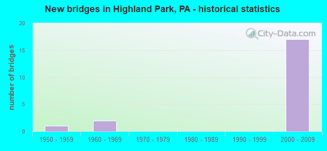
- New bridges - historical statistics
- 11950-1959
- 21960-1969
- 172000-2009


- Bridge Condition - Deck
- 25.0%Very good
- 62.5%Good
- 12.5%Poor

- Bridge Condition - Superstructure
- 75.0%Very good
- 12.5%Good
- 12.5%Poor

- Bridge Condition - Substructure
- 25.0%Very good
- 62.5%Good
- 12.5%Fair

- Bridge Condition - Channel
- 25.0%Excellent
- 12.5%Very good
- 12.5%Good
- 50.0%Satisfactory

- Bridge Condition - Culverts
- 33.3%Very good
- 66.7%Satisfactory
Find on map >> Show street view
Structure Number: 26434, Location: 1 MI W BURNHAM (Lat: 40.625481, Lng: -77.581967), Route carried "on" structure: US 322, Year Built: 1964, Status: Open, Structure Length: 1.40m (4.59ft), Average Daily Traffic: 24,537 (year 2022), Truck Traffic: 12%, Average Future Daily Traffic: 29,751 (year 2040), Design Load: HS 20, Features Intersected: BUCK RUN
Minimum Vertical Clearance: 30+ m (98+ ft), Kilometerpoint: 18.612, Lanes on structure: 2, Base Highway Network: Yes, Owner: State Highway Agency, Approaching Roadway Width: 13.4m (44.0ft), Material/Design: Concrete, Design/Construction: Culvert, Number Of Spans In Main Unit: 1, Length of Maximum Span: 14.0m (45.9ft)
Condition: Channel: Satisfactory, Culverts: Satisfactory, Operating Rating: 54.4 metric tons, Method Used To Determine Operating Rating: Field evaluation and documented engineering judgment, Inventory Rating: 32.7 metric tons, Method Used To Determine Inventory Rating: Field evaluation and documented engineering judgment, Structural Evaluation: Equal to present minimum criteria, Waterway Adequacy: Superior to present desirable criteria, Approach Roadway Alignment: Equal to present desirable criteria, Length Of Structure Improvement: 1.40m (4.59ft), Designated Inspection Frequency: Every 24 months, Inspection Date: May 2020
Find on map >> Show street view
Structure Number: 26436, Location: 1 MI N LEWISTOWN (Lat: 40.613553, Lng: -77.569644), Route carried "on" structure: US 22, Year Built: 1958, Status: Open, Structure Length: 0.70m (2.30ft), Average Daily Traffic: 34,178 (year 2021), Truck Traffic: 13%, Average Future Daily Traffic: 47,256 (year 2040), Design Load: HS 20, Features Intersected: BRANCH KISHACOQUILLAS CR
Minimum Vertical Clearance: 30+ m (98+ ft), Kilometerpoint: 38.001, Lanes on structure: 10, Base Highway Network: Yes, Owner: State Highway Agency, Approaching Roadway Width: 45.1m (148.0ft), Skew: 23 degrees, Material/Design: Concrete, Design/Construction: Culvert, Number Of Spans In Main Unit: 1, Length of Maximum Span: 7.0m (23.0ft)
Condition: Channel: Satisfactory, Culverts: Satisfactory, Operating Rating: 54.4 metric tons, Method Used To Determine Operating Rating: Field evaluation and documented engineering judgment, Inventory Rating: 32.7 metric tons, Method Used To Determine Inventory Rating: Field evaluation and documented engineering judgment, Structural Evaluation: Equal to present minimum criteria, Waterway Adequacy: Superior to present desirable criteria, Approach Roadway Alignment: Equal to present desirable criteria, Length Of Structure Improvement: 0.70m (2.30ft), Designated Inspection Frequency: Every 24 months, Inspection Date: May 2020
Find on map >> Show street view
Structure Number: 26634, Location: 900 FT SOUTH OF SR 4013 (Lat: 40.624411, Lng: -77.585819), Route carried "on" structure: City street , Year Built: 1960, Status: Posted for load, Structure Length: 1.25m (4.10ft), Average Daily Traffic: 40 (year 2021), Truck Traffic: 10%, Average Future Daily Traffic: 50 (year 2041), Design Load: HS 20, Features Intersected: BUCK RUN, Facility Carried by Structure: T-783
Minimum Vertical Clearance: 30+ m (98+ ft), Kilometerpoint: 0.000, Lanes on structure: 2, Owner: Town or Township Highway Agency, Approaching Roadway Width: 5.8m (19.0ft), Skew: 1 degrees, Material/Design: Prestressed concrete, Design/Construction: Box Beam or Girders - Multiple, Number Of Spans In Main Unit: 1, Length of Maximum Span: 11.9m (39.0ft), Curb or Sidewalk Widths: Left: 0.2m (0.7ft), Right: 0.2m (0.7ft), Curb-To-Curb Width: 9.7m (31.8ft), Out-to-Out Width: 10.3m (33.8ft)
Condition: Deck: Poor, Superstructure: Poor, Substructure: Fair, Channel: Satisfactory, Operating Rating: 41.7 metric tons, Method Used To Determine Operating Rating: Load Factor (LF), Inventory Rating: 22.7 metric tons, Method Used To Determine Inventory Rating: Load Factor (LF), Structural Evaluation: Meets minimum limits, Deck Geometry: Better than present minimum criteria, Waterway Adequacy: Better than present minimum criteria, Approach Roadway Alignment: Equal to present desirable criteria, Bridge Posting: Required (Relationship of Operating Rating to Maximum Legal Load: 0.1 - 9.9% below), Length Of Structure Improvement: 1.90m (6.23ft), Designated Inspection Frequency: Every 24 months, Other Special Inspection Frequency: Every 12 months, Inspection Date: March 2021, Other Special Inspection Date: March 2021, Bridge Improvement Cost: $12,000, Roadway Improvement Cost: $36,000, Total Project Cost: $165,000, Deck Structure Type: Other, Wearing Surface/Protective System: Wearing Surface: Bituminous
Find on map >> Show street view
Structure Number: 41378, Location: LEWISTOWN (Lat: 40.613292, Lng: -77.569964), Route carried "on" structure: US 22, Year Built: 2001, Status: Open, Structure Length: 4.75m (15.58ft), Average Daily Traffic: 10,987 (year 2021), Truck Traffic: 18%, Average Future Daily Traffic: 15,436 (year 2040), Design Load: H 15, Features Intersected: SR 1005 ELECTRIC AVENUE
Minimum Vertical Clearance: 30+ m (98+ ft), Kilometerpoint: 38.022, Lanes on structure: 2, Lanes under structure: 3, Base Highway Network: Yes, Owner: State Highway Agency, Approaching Roadway Width: 12.2m (40.0ft), Skew: 4 degrees, Material/Design: Steel, Design/Construction: Stringer/Multi-beam, Number Of Spans In Main Unit: 1, Length of Maximum Span: 46.0m (150.9ft), Curb or Sidewalk Widths: Left: 0.2m (0.7ft), Right: 0.2m (0.7ft), Curb-To-Curb Width: 12.3m (40.4ft), Out-to-Out Width: 13.2m (43.3ft)
Condition: Deck: Good, Superstructure: Very good, Substructure: Good, Inventory Rating: 77.1 metric tons, Method Used To Determine Inventory Rating: Load Factor (LF), Structural Evaluation: Better than present minimum criteria, Deck Geometry: Better than present minimum criteria, Underclear: Equal to present minimum criteria, Approach Roadway Alignment: Equal to present desirable criteria, Length Of Structure Improvement: 5.70m (18.70ft), Designated Inspection Frequency: Every 24 months, Inspection Date: May 2020, Deck Structure Type: Concrete Cast-file-Place, Wearing Surface/Protective System: Wearing Surface: Monolithic Concrete, Deck Protection: Epoxy Coated Reinforcing
Find on map >> Show street view
Structure Number: 41737, Location: 0.5 MI WEST OF LEWISTOWN (Lat: 40.617700, Lng: -77.576406), Route carried "on" structure: Ramp State highway , Year Built: 2002, Status: Open, Structure Length: 3.14m (10.30ft), Average Daily Traffic: 3,077 (year 2022), Truck Traffic: 8%, Average Future Daily Traffic: 3,305 (year 2040), Design Load: HL 93, Features Intersected: SR 3023, Facility Carried by Structure: SR 8014
Minimum Vertical Clearance: 30+ m (98+ ft), Kilometerpoint: 0.000, Lanes on structure: 2, Lanes under structure: 3, Owner: State Highway Agency, Approaching Roadway Width: 13.1m (43.0ft), Skew: 1 degrees, Material/Design: Prestressed concrete, Design/Construction: Stringer/Multi-beam, Number Of Spans In Main Unit: 1, Length of Maximum Span: 30.8m (101.0ft), Curb or Sidewalk Widths: Left: 0.1m (0.3ft), Right: 0.1m (0.3ft), Curb-To-Curb Width: 13.1m (43.0ft), Out-to-Out Width: 14.0m (45.9ft)
Condition: Deck: Very good, Superstructure: Very good, Substructure: Good, Operating Rating: 83.5 metric tons, Method Used To Determine Operating Rating: Load Factor (LF), Inventory Rating: 35.4 metric tons, Method Used To Determine Inventory Rating: Load Factor (LF), Structural Evaluation: Better than present minimum criteria, Deck Geometry: Superior to present desirable criteria, Underclear: Meets minimum limits, Approach Roadway Alignment: Equal to present desirable criteria, Length Of Structure Improvement: 3.90m (12.80ft), Designated Inspection Frequency: Every 24 months, Inspection Date: May 2020, Deck Structure Type: Concrete Cast-file-Place, Wearing Surface/Protective System: Wearing Surface: Epoxy Overlay, Deck Protection: Epoxy Coated Reinforcing
Find on map >> Show street view
Structure Number: 41738, Location: 0.5 MI WEST OF LEWISTOWN (Lat: 40.617561, Lng: -77.576267), Route carried "on" structure: Ramp State highway , Year Built: 2002, Status: Open, Structure Length: 5.46m (17.91ft), Average Daily Traffic: 3,077 (year 2022), Truck Traffic: 8%, Average Future Daily Traffic: 3,305 (year 2040), Design Load: HS 25 or greater, Features Intersected: TR. KISHACOQUILLAS CREEK, Facility Carried by Structure: SR 8014
Minimum Vertical Clearance: 30+ m (98+ ft), Kilometerpoint: 0.000, Lanes on structure: 2, Base Highway Network: Yes, Owner: State Highway Agency, Approaching Roadway Width: 13.1m (43.0ft), Skew: 1 degrees, Material/Design: Prestressed concrete continuous, Design/Construction: Stringer/Multi-beam, Number Of Spans In Main Unit: 2, Length of Maximum Span: 34.7m (113.8ft), Curb or Sidewalk Widths: Left: 0.1m (0.3ft), Right: 0.1m (0.3ft), Curb-To-Curb Width: 13.1m (43.0ft), Out-to-Out Width: 14.0m (45.9ft)
Condition: Deck: Good, Superstructure: Good, Substructure: Very good, Channel: Excellent, Operating Rating: 56.2 metric tons, Method Used To Determine Operating Rating: Load Factor (LF), Inventory Rating: 33.6 metric tons, Method Used To Determine Inventory Rating: Load Factor (LF), Structural Evaluation: Better than present minimum criteria, Deck Geometry: Superior to present desirable criteria, Waterway Adequacy: Superior to present desirable criteria, Approach Roadway Alignment: Equal to present desirable criteria, Length Of Structure Improvement: 6.40m (21.00ft), Designated Inspection Frequency: Every 24 months, Inspection Date: May 2020, Deck Structure Type: Concrete Cast-file-Place, Wearing Surface/Protective System: Wearing Surface: Epoxy Overlay, Deck Protection: Epoxy Coated Reinforcing
Find on map >> Show street view
Structure Number: 42121, Location: 0.5 MI. N OF LEWISTOWN (Lat: 40.615897, Lng: -77.573264), Route carried "on" structure: Ramp State highway , Year Built: 2003, Status: Open, Structure Length: 26.43m (86.71ft), Average Daily Traffic: 1,794 (year 2022), Truck Traffic: 8%, Average Future Daily Traffic: 2,068 (year 2020), Design Load: HS 25 or greater, Features Intersected: ORT RD 322 & 22 RP A & H, Facility Carried by Structure: SR 8014 RAMP C
Minimum Vertical Clearance: 30+ m (98+ ft), Kilometerpoint: 0.000, Lanes on structure: 1, Lanes under structure: 9, Base Highway Network: Yes, Owner: State Highway Agency, Approaching Roadway Width: 8.8m (28.9ft), Skew: 3 degrees, Material/Design: Steel continuous, Design/Construction: Stringer/Multi-beam, Number Of Spans In Main Unit: 5, Length of Maximum Span: 57.3m (188.0ft), Curb or Sidewalk Widths: Left: 0.1m (0.3ft), Right: 0.1m (0.3ft), Curb-To-Curb Width: 10.7m (35.1ft), Out-to-Out Width: 11.5m (37.7ft)
Condition: Deck: Very good, Superstructure: Very good, Substructure: Good, Operating Rating: 68.0 metric tons, Method Used To Determine Operating Rating: Load Factor (LF), Inventory Rating: 40.8 metric tons, Method Used To Determine Inventory Rating: Load Factor (LF), Structural Evaluation: Better than present minimum criteria, Deck Geometry: Superior to present desirable criteria, Underclear: High priority of corrective action, Approach Roadway Alignment: Equal to present desirable criteria, Length Of Structure Improvement: 26.90m (88.25ft), Designated Inspection Frequency: Every 24 months, Inspection Date: May 2020, Deck Structure Type: Concrete Cast-file-Place, Wearing Surface/Protective System: Wearing Surface: Epoxy Overlay, Deck Protection: Epoxy Coated Reinforcing
Find on map >> Show street view
Structure Number: 42125, Location: 0.5 MI W LEWISTOWN (Lat: 40.615700, Lng: -77.573533), Route carried "on" structure: Ramp US 22, Year Built: 2003, Status: Open, Structure Length: 14.33m (47.01ft), Average Daily Traffic: 1,823 (year 2020), Truck Traffic: 22%, Average Future Daily Traffic: 15,436 (year 2040), Design Load: HS 25 or greater, Features Intersected: SR 322 EB/TRIB KISH CR
Minimum Vertical Clearance: 6.89m (22.60ft), Kilometerpoint: 37.625, Lanes on structure: 1, Lanes under structure: 2, Base Highway Network: Yes, Owner: State Highway Agency, Approaching Roadway Width: 10.1m (33.1ft), Skew: 30 degrees, Material/Design: Steel continuous, Design/Construction: Stringer/Multi-beam, Number Of Spans In Main Unit: 3, Length of Maximum Span: 57.9m (190.0ft), Curb or Sidewalk Widths: Left: 0.2m (0.7ft), Right: 0.2m (0.7ft), Curb-To-Curb Width: 10.1m (33.1ft), Out-to-Out Width: 10.9m (35.8ft)
Condition: Deck: Good, Superstructure: Very good, Substructure: Good, Channel: Excellent, Operating Rating: 68.0 metric tons, Method Used To Determine Operating Rating: Load Factor (LF), Inventory Rating: 40.8 metric tons, Method Used To Determine Inventory Rating: Load Factor (LF), Structural Evaluation: Better than present minimum criteria, Deck Geometry: Superior to present desirable criteria, Underclear: Meets minimum limits, Waterway Adequacy: Superior to present desirable criteria, Approach Roadway Alignment: Equal to present desirable criteria, Length Of Structure Improvement: 15.30m (50.20ft), Designated Inspection Frequency: Every 24 months, Inspection Date: May 2020, Deck Structure Type: Concrete Cast-file-Place, Wearing Surface/Protective System: Wearing Surface: Epoxy Overlay, Deck Protection: Epoxy Coated Reinforcing
Find on map >> Show street view
Structure Number: 42354, Location: 1 MILE SOUTH WEST BURNHAM (Lat: 40.620189, Lng: -77.596722), Route carried "on" structure: State highway , Year Built: 2004, Status: Open, Structure Length: 0.79m (2.59ft), Average Daily Traffic: 1,278 (year 2022), Truck Traffic: 4%, Average Future Daily Traffic: 1,894 (year 2040), Design Load: HL 93, Features Intersected: TRIB TO BUCK RUN, Facility Carried by Structure: SR 4013
Minimum Vertical Clearance: 30+ m (98+ ft), Kilometerpoint: 9.946, Lanes on structure: 2, Owner: State Highway Agency, Approaching Roadway Width: 9.1m (29.9ft), Skew: 2 degrees, Material/Design: Concrete, Design/Construction: Culvert, Number Of Spans In Main Unit: 1, Length of Maximum Span: 7.9m (25.9ft)
Condition: Channel: Satisfactory, Culverts: Very good, Inventory Rating: 88.9 metric tons, Method Used To Determine Inventory Rating: Load Factor (LF), Structural Evaluation: Equal to present desirable criteria, Waterway Adequacy: Equal to present desirable criteria, Approach Roadway Alignment: Equal to present desirable criteria, Length Of Structure Improvement: 1.40m (4.59ft), Designated Inspection Frequency: Every 24 months, Inspection Date: October 2020
Find on map >> Show street view
Structure Number: 42756, Location: 100' S OF INTER SR 4013 (Lat: 40.628728, Lng: -77.572431), Route carried "on" structure: City street , Year Built: 2005, Status: Open, Structure Length: 1.52m (4.99ft), Average Daily Traffic: 66 (year 2021), Average Future Daily Traffic: 102 (year 2041), Design Load: HL 93, Features Intersected: BUCK RUN, Facility Carried by Structure: T-781 COMMONS BLVD
Minimum Vertical Clearance: 30+ m (98+ ft), Kilometerpoint: 0.000, Lanes on structure: 2, Owner: Town or Township Highway Agency, Approaching Roadway Width: 8.5m (27.9ft), Skew: 1 degrees, Material/Design: Prestressed concrete, Design/Construction: Box Beam or Girders - Single/Spread, Number Of Spans In Main Unit: 1, Length of Maximum Span: 14.6m (47.9ft), Curb or Sidewalk Widths: Left: 0.2m (0.7ft), Right: 1.6m (5.2ft), Curb-To-Curb Width: 8.5m (27.9ft), Out-to-Out Width: 10.8m (35.4ft)
Condition: Deck: Good, Superstructure: Very good, Substructure: Good, Channel: Good, Operating Rating: 44.5 metric tons, Method Used To Determine Operating Rating: Load and Resistance Factor (LRFR), Inventory Rating: 34.5 metric tons, Method Used To Determine Inventory Rating: Load and Resistance Factor (LRFR), Structural Evaluation: Better than present minimum criteria, Deck Geometry: Better than present minimum criteria, Waterway Adequacy: Superior to present desirable criteria, Approach Roadway Alignment: Equal to present desirable criteria, Length Of Structure Improvement: 2.10m (6.89ft), Designated Inspection Frequency: Every 24 months, Inspection Date: March 2021, Deck Structure Type: Concrete Cast-file-Place, Wearing Surface/Protective System: Wearing Surface: Monolithic Concrete, Membrane: Other, Deck Protection: Epoxy Coated Reinforcing
Find on map >> Show street view
Structure Number: 45663, Location: 2 MILES NORTH LEWISTOWN (Lat: 40.617625, Lng: -77.560414), Route carried "on" structure: State highway , Year Built: 2009, Status: Open, Structure Length: 2.93m (9.61ft), Average Daily Traffic: 1,828 (year 2021), Truck Traffic: 2%, Average Future Daily Traffic: 2,127 (year 2040), Design Load: HL 93, Features Intersected: KISHACOQUILLAS CREEK, Facility Carried by Structure: SR 2007
Minimum Vertical Clearance: 30+ m (98+ ft), Kilometerpoint: 0.000, Lanes on structure: 2, Owner: State Highway Agency, Approaching Roadway Width: 9.8m (32.2ft), Material/Design: Prestressed concrete continuous, Design/Construction: Box Beam or Girders - Single/Spread, Number Of Spans In Main Unit: 2, Length of Maximum Span: 14.6m (47.9ft), Curb-To-Curb Width: 9.8m (32.2ft), Out-to-Out Width: 10.7m (35.1ft)
Condition: Deck: Good, Superstructure: Very good, Substructure: Very good, Channel: Very good, Inventory Rating: 54.4 metric tons, Method Used To Determine Inventory Rating: Load Factor (LF), Structural Evaluation: Equal to present desirable criteria, Deck Geometry: Somewhat better than minimum adequacy, Waterway Adequacy: Better than present minimum criteria, Approach Roadway Alignment: Equal to present desirable criteria, Designated Inspection Frequency: Every 24 months, Underwater Inspection Frequency: Every 60 months, Inspection Date: May 2020, Underwater Inspection Date: November 2019, Deck Structure Type: Concrete Cast-file-Place, Wearing Surface/Protective System: Wearing Surface: Monolithic Concrete, Deck Protection: Epoxy Coated Reinforcing
Find on map >> Show street view
Structure Number: 41378, Location: LEWISTOWN (Lat: 40.613292, Lng: -77.569964), Route carried "under" structure: State highway , Year Built: 2001, Structure Length: 0. m, Average Daily Traffic: 8,388 (year 2022), Truck Traffic: 5%, Features Intersected: SR 1005 ELECTRIC AVENUE, Facility Carried by Structure: SR 22-US 22
Minimum Vertical Clearance: 4.47m (14.67ft), Kilometerpoint: 2.297, Lanes on structure: 2, Lanes under structure: 3, Material/Design: Steel, Design/Construction: Stringer/Multi-beam, Length of Maximum Span: 46.0m (150.9ft)
Find on map >> Show street view
Structure Number: 41737, Location: 0.5 MI WEST OF LEWISTOWN (Lat: 40.617700, Lng: -77.576406), Route carried "under" structure: State highway , Year Built: 2002, Structure Length: 0. m, Average Daily Traffic: 5,018 (year 2020), Truck Traffic: 2%, Features Intersected: SR 3023, Facility Carried by Structure: SR 8014
Minimum Vertical Clearance: 5.06m (16.60ft), Kilometerpoint: 0.000, Lanes on structure: 2, Lanes under structure: 3, Material/Design: Prestressed concrete, Design/Construction: Stringer/Multi-beam, Length of Maximum Span: 30.8m (101.0ft)
Find on map >> Show street view
Structure Number: 42121, Location: 0.5 MI. N OF LEWISTOWN (Lat: 40.615897, Lng: -77.573264), Route carried "under" structure: US 322, Year Built: 2003, Structure Length: 0. m, Average Daily Traffic: 12,143 (year 2022), Truck Traffic: 13%, Features Intersected: ORT RD 322 & 22 RP A & H, Facility Carried by Structure: SR 8014 RAMP C
Minimum Vertical Clearance: 5.06m (16.60ft), Kilometerpoint: 19.587, Lanes on structure: 1, Lanes under structure: 1, Material/Design: Steel continuous, Design/Construction: Stringer/Multi-beam, Length of Maximum Span: 57.3m (188.0ft)
Find on map >> Show street view
Structure Number: 42121, Location: 0.5 MI. N OF LEWISTOWN (Lat: 40.615897, Lng: -77.573264), Route carried "under" structure: US 22, Year Built: 2003, Structure Length: 0. m, Average Daily Traffic: 2,249 (year 2020), Truck Traffic: 19%, Features Intersected: ORT RD 322 & 22 RP A & H, Facility Carried by Structure: SR 8014 RAMP C
Minimum Vertical Clearance: 6.81m (22.34ft), Kilometerpoint: 37.470, Lanes on structure: 1, Lanes under structure: 2, Material/Design: Steel continuous, Design/Construction: Stringer/Multi-beam, Length of Maximum Span: 57.3m (188.0ft)
Find on map >> Show street view
Structure Number: 42121, Location: 0.5 MI. N OF LEWISTOWN (Lat: 40.615897, Lng: -77.573264), Route carried "under" structure: Ramp State lands road 8014, Year Built: 2003, Structure Length: 0. m, Average Daily Traffic: 10,130 (year 2005), Truck Traffic: 13%, Features Intersected: ORT RD 322 & 22 RP A & H
Minimum Vertical Clearance: 14.78m (48.49ft), Kilometerpoint: 0.000, Lanes on structure: 1, Lanes under structure: 1, Material/Design: Steel continuous, Design/Construction: Stringer/Multi-beam, Length of Maximum Span: 57.3m (188.0ft)
Find on map >> Show street view
Structure Number: 42121, Location: 0.5 MI. N OF LEWISTOWN (Lat: 40.615897, Lng: -77.573264), Route carried "under" structure: State highway , Year Built: 2003, Structure Length: 0. m, Average Daily Traffic: 5,018 (year 2020), Truck Traffic: 2%, Features Intersected: ORT RD 322 & 22 RP A & H, Facility Carried by Structure: SR 8014 RAMP C
Minimum Vertical Clearance: 30+ m (98+ ft), Kilometerpoint: 0.000, Lanes on structure: 1, Lanes under structure: 2, Material/Design: Steel continuous, Design/Construction: Stringer/Multi-beam, Length of Maximum Span: 57.3m (188.0ft)
Find on map >> Show street view
Structure Number: 42121, Location: 0.5 MI. N OF LEWISTOWN (Lat: 40.615897, Lng: -77.573264), Route carried "under" structure: US 22, Year Built: 2003, Structure Length: 0. m, Average Daily Traffic: 1,823 (year 2020), Truck Traffic: 22%, Features Intersected: ORT RD 322 & 22 RP A & H, Facility Carried by Structure: SR 8014 RAMP C
Minimum Vertical Clearance: 6.81m (22.34ft), Kilometerpoint: 37.625, Lanes on structure: 1, Lanes under structure: 2, Material/Design: Steel continuous, Design/Construction: Stringer/Multi-beam, Length of Maximum Span: 57.3m (188.0ft)
Find on map >> Show street view
Structure Number: 42121, Location: 0.5 MI. N OF LEWISTOWN (Lat: 40.615897, Lng: -77.573264), Route carried "under" structure: US 322, Year Built: 2003, Structure Length: 0. m, Average Daily Traffic: 12,394 (year 2022), Truck Traffic: 12%, Features Intersected: ORT RD 322 & 22 RP A & H, Facility Carried by Structure: SR 8014 RAMP C
Minimum Vertical Clearance: 5.46m (17.91ft), Kilometerpoint: 19.611, Lanes on structure: 1, Lanes under structure: 1, Material/Design: Steel continuous, Design/Construction: Stringer/Multi-beam, Length of Maximum Span: 57.3m (188.0ft)
Find on map >> Show street view
Structure Number: 42125, Location: 0.5 MI W LEWISTOWN (Lat: 40.615700, Lng: -77.573533), Route carried "under" structure: US 322, Year Built: 2003, Structure Length: 0. m, Average Daily Traffic: 12,143 (year 2022), Truck Traffic: 13%, Features Intersected: SR 322 EB/TRIB KISH CR, Facility Carried by Structure: SR 22-US 22
Minimum Vertical Clearance: 5.18m (16.99ft), Kilometerpoint: 19.587, Lanes on structure: 1, Lanes under structure: 2, Material/Design: Steel continuous, Design/Construction: Stringer/Multi-beam, Length of Maximum Span: 57.9m (190.0ft)