Bridge Statistics for Highgate, Vermont (VT)
Condition, Traffic, Stress, Structural Evaluation, Project Costs
- National Bridge Inventory (NBI) Statistics
- 14Number of bridges
- 233ft / 71.1mTotal length
- $1,787,000Total costs
- 27,360Total average daily traffic
- 2,946Total average daily truck traffic
- National Bridge Inventory (NBI) Registered Bridges for Highgate
- No street view available for this location
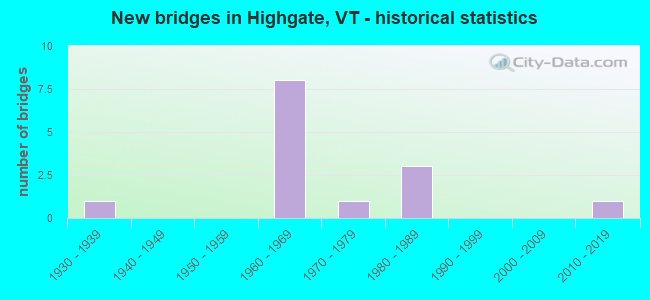
- New bridges - historical statistics
- 11930-1939
- 81960-1969
- 11970-1979
- 31980-1989
- 12010-2019

- Reconstructed bridges - Historical Statistics
- 11990-1999
- 12000-2009


- Bridge Condition - Deck
- 20.0%Very good
- 70.0%Good
- 10.0%Satisfactory

- Bridge Condition - Superstructure
- 30.0%Very good
- 60.0%Good
- 10.0%Satisfactory

- Bridge Condition - Substructure
- 20.0%Very good
- 70.0%Good
- 10.0%Satisfactory

- Bridge Condition - Channel
- 75.0%Very good
- 25.0%Good
Find on map >> Show street view
Structure Number: 100609002306091, Location: 0.4 MI N JCT US RTE 7 (Lat: 44.996972, Lng: -73.072628), Route carried "on" structure: Other road C2006, Year Built: 1981, Status: Open, Structure Length: 2.50m (8.20ft), Average Daily Traffic: 180 (year 2019), Truck Traffic: 2%, Average Future Daily Traffic: 189 (year 2029), Design Load: HS 20, Features Intersected: ROCK RIVER
Minimum Vertical Clearance: 30+ m (98+ ft), Kilometerpoint: 0.000, Lanes on structure: 2, Owner: Town or Township Highway Agency, Approaching Roadway Width: 7.3m (24.0ft), Skew: 1 degrees, Material/Design: Steel, Design/Construction: Stringer/Multi-beam, Number Of Spans In Main Unit: 1, Length of Maximum Span: 23.2m (76.1ft), Curb or Sidewalk Widths: Left: 0.2m (0.7ft), Right: 0.2m (0.7ft), Curb-To-Curb Width: 6.9m (22.6ft), Out-to-Out Width: 7.7m (25.3ft)
Condition: Deck: Very good, Superstructure: Very good, Substructure: Very good, Channel: Good, Operating Rating: 56.2 metric tons, Method Used To Determine Operating Rating: Allowable Stress (AS), Inventory Rating: 35.4 metric tons, Method Used To Determine Inventory Rating: Allowable Stress (AS), Structural Evaluation: Equal to present desirable criteria, Deck Geometry: Meets minimum limits, Waterway Adequacy: Better than present minimum criteria, Approach Roadway Alignment: Equal to present desirable criteria, Designated Inspection Frequency: Every 24 months, Inspection Date: September 2021, Deck Structure Type: Concrete Cast-file-Place
Find on map >> Show street view
Structure Number: 100609002406091, Location: 0.1 MI TO JCT W CL4 TH23 (Lat: 44.978842, Lng: -73.025292), Route carried "on" structure: Other road C3022, Year Built: 1939, Year Reconstructed: 1996, Status: Open, Structure Length: 2.56m (8.40ft), Average Daily Traffic: 100 (year 2019), Truck Traffic: 2%, Average Future Daily Traffic: 105 (year 2029), Features Intersected: ROCK RIVER
Minimum Vertical Clearance: 30+ m (98+ ft), Kilometerpoint: 0.000, Lanes on structure: 2, Owner: Town or Township Highway Agency, Approaching Roadway Width: 7.9m (25.9ft), Material/Design: Steel, Design/Construction: Stringer/Multi-beam, Number Of Spans In Main Unit: 1, Length of Maximum Span: 25.0m (82.0ft), Curb or Sidewalk Widths: Left: 0.1m (0.3ft), Right: 0.1m (0.3ft), Curb-To-Curb Width: 7.8m (25.6ft), Out-to-Out Width: 8.7m (28.5ft)
Condition: Deck: Good, Superstructure: Good, Substructure: Good, Channel: Very good, Operating Rating: 43.5 metric tons, Method Used To Determine Operating Rating: Allowable Stress (AS), Inventory Rating: 26.3 metric tons, Method Used To Determine Inventory Rating: Allowable Stress (AS), Structural Evaluation: Equal to present minimum criteria, Deck Geometry: Equal to present minimum criteria, Waterway Adequacy: Equal to present desirable criteria, Approach Roadway Alignment: Better than present minimum criteria, Designated Inspection Frequency: Every 24 months, Inspection Date: September 2021, Deck Structure Type: Concrete Cast-file-Place, Wearing Surface/Protective System: Wearing Surface: Bituminous
Find on map >> Show street view
Structure Number: 100609002506091, Location: 0.02 MI TO JCT W VT78 (Lat: 44.927369, Lng: -72.987447), Route carried "on" structure: Other road C2004, Year Built: 2019, Status: Open, Structure Length: 8.90m (29.20ft), Average Daily Traffic: 1,200 (year 2019), Truck Traffic: 2%, Average Future Daily Traffic: 1,260 (year 2029), Design Load: HL 93, Features Intersected: MISSISQUOI RIVER
Minimum Vertical Clearance: 4.74m (15.55ft), Kilometerpoint: 0.000, Lanes on structure: 1, Owner: Town or Township Highway Agency, Approaching Roadway Width: 6.1m (20.0ft), Material/Design: Steel continuous, Design/Construction: Stringer/Multi-beam, Number Of Spans In Main Unit: 2, Length of Maximum Span: 43.6m (143.0ft), Curb or Sidewalk Widths: Left: 0.1m (0.3ft), Right: 0.1m (0.3ft), Curb-To-Curb Width: 4.8m (15.7ft), Out-to-Out Width: 5.2m (17.1ft)
Condition: Deck: Very good, Superstructure: Very good, Substructure: Very good, Channel: Very good, Operating Rating: 46.3 metric tons, Method Used To Determine Operating Rating: Load and Resistance Factor (LRFR), Inventory Rating: 35.4 metric tons, Method Used To Determine Inventory Rating: Load and Resistance Factor (LRFR), Structural Evaluation: Equal to present desirable criteria, Deck Geometry: High priority of corrective action, Waterway Adequacy: Better than present minimum criteria, Approach Roadway Alignment: Equal to present desirable criteria, Length Of Structure Improvement: 8.90m (29.20ft), Designated Inspection Frequency: Every 24 months, Inspection Date: September 2021, Bridge Improvement Cost: $1,737,000, Roadway Improvement Cost: $50,000, Total Project Cost: $1,787,000 ( Estimate for 2020), Deck Structure Type: Concrete Cast-file-Place
Find on map >> Show street view
Structure Number: 200089100N06092, Location: 1.5 MI S EXIT 22 (Lat: 44.988506, Lng: -73.086414), Route carried "on" structure: Interstate 89, Year Built: 1965, Status: Open, Structure Length: 9.05m (29.69ft), Average Daily Traffic: 3,400 (year 2018), Truck Traffic: 13%, Average Future Daily Traffic: 3,570 (year 2028), Design Load: HS 20, Features Intersected: ROCK RIVER
Minimum Vertical Clearance: 30+ m (98+ ft), Kilometerpoint: 206.547, Lanes on structure: 2, Base Highway Network: Yes, Owner: State Highway Agency, Approaching Roadway Width: 11.6m (38.1ft), Skew: 10 degrees, Material/Design: Steel, Design/Construction: Stringer/Multi-beam, Number Of Spans In Main Unit: 3, Length of Maximum Span: 29.6m (97.1ft), Curb or Sidewalk Widths: Left: 0.3m (1.0ft), Right: 0.3m (1.0ft), Curb-To-Curb Width: 9.1m (29.9ft), Out-to-Out Width: 10.6m (34.8ft)
Condition: Deck: Good, Superstructure: Good, Substructure: Good, Channel: Very good, Operating Rating: 89.8 metric tons, Method Used To Determine Operating Rating: Load Factor (LF), Inventory Rating: 54.4 metric tons, Method Used To Determine Inventory Rating: Load Factor (LF), Structural Evaluation: Better than present minimum criteria, Deck Geometry: Meets minimum limits, Waterway Adequacy: Equal to present desirable criteria, Approach Roadway Alignment: Equal to present desirable criteria, Designated Inspection Frequency: Every 24 months, Underwater Inspection Frequency: Every 48 months, Inspection Date: June 2020, Underwater Inspection Date: August 2018, Deck Structure Type: Concrete Cast-file-Place, Wearing Surface/Protective System: Wearing Surface: Bituminous, Membrane: Preformed Fabric
Find on map >> Show street view
Structure Number: 200089100S06092, Location: 1.5 MI S EXIT 22 (Lat: 44.988575, Lng: -73.086678), Route carried "on" structure: Interstate 89, Year Built: 1965, Status: Open, Structure Length: 9.05m (29.69ft), Average Daily Traffic: 3,400 (year 2018), Truck Traffic: 13%, Average Future Daily Traffic: 3,570 (year 2028), Design Load: HS 20, Features Intersected: ROCK RIVER
Minimum Vertical Clearance: 30+ m (98+ ft), Kilometerpoint: 206.547, Lanes on structure: 2, Base Highway Network: Yes, Owner: State Highway Agency, Approaching Roadway Width: 11.6m (38.1ft), Skew: 10 degrees, Material/Design: Steel, Design/Construction: Stringer/Multi-beam, Number Of Spans In Main Unit: 3, Length of Maximum Span: 29.6m (97.1ft), Curb or Sidewalk Widths: Left: 0.3m (1.0ft), Right: 0.3m (1.0ft), Curb-To-Curb Width: 9.1m (29.9ft), Out-to-Out Width: 10.6m (34.8ft)
Condition: Deck: Good, Superstructure: Good, Substructure: Good, Channel: Very good, Operating Rating: 89.8 metric tons, Method Used To Determine Operating Rating: Load Factor (LF), Inventory Rating: 57.2 metric tons, Method Used To Determine Inventory Rating: Load Factor (LF), Structural Evaluation: Better than present minimum criteria, Deck Geometry: Meets minimum limits, Waterway Adequacy: Equal to present desirable criteria, Approach Roadway Alignment: Equal to present desirable criteria, Designated Inspection Frequency: Every 24 months, Underwater Inspection Frequency: Every 48 months, Inspection Date: June 2020, Underwater Inspection Date: August 2018, Deck Structure Type: Concrete Cast-file-Place, Wearing Surface/Protective System: Wearing Surface: Bituminous, Membrane: Preformed Fabric
Find on map >> Show street view
Structure Number: 200285018206092, Location: 5.3 MI N JCT. VT.78 W (Lat: 44.988997, Lng: -73.088303), Route carried "on" structure: US 7, Year Built: 1984, Status: Open, Structure Length: 2.80m (9.19ft), Average Daily Traffic: 420 (year 2018), Truck Traffic: 6%, Average Future Daily Traffic: 441 (year 2028), Design Load: HS 25 or greater, Features Intersected: ROCK RIVER
Minimum Vertical Clearance: 30+ m (98+ ft), Kilometerpoint: 0.000, Lanes on structure: 2, Owner: State Highway Agency, Approaching Roadway Width: 11.6m (38.1ft), Material/Design: Steel, Design/Construction: Stringer/Multi-beam, Number Of Spans In Main Unit: 1, Length of Maximum Span: 27.4m (89.9ft), Curb or Sidewalk Widths: Left: 0.2m (0.7ft), Right: 0.2m (0.7ft), Curb-To-Curb Width: 10.0m (32.8ft), Out-to-Out Width: 11.3m (37.1ft)
Condition: Deck: Good, Superstructure: Very good, Substructure: Good, Channel: Good, Operating Rating: 89.8 metric tons, Method Used To Determine Operating Rating: Load Factor (LF), Inventory Rating: 65.3 metric tons, Method Used To Determine Inventory Rating: Load Factor (LF), Structural Evaluation: Better than present minimum criteria, Deck Geometry: Equal to present minimum criteria, Waterway Adequacy: Equal to present minimum criteria, Approach Roadway Alignment: Equal to present desirable criteria, Designated Inspection Frequency: Every 24 months, Inspection Date: July 2021, Deck Structure Type: Concrete Cast-file-Place, Wearing Surface/Protective System: Wearing Surface: Bituminous, Membrane: Preformed Fabric, Deck Protection: Epoxy Coated Reinforcing
Find on map >> Show street view
Structure Number: 200285018306092, Location: 1.5 MI S CANADIAN BORDER (Lat: 44.993744, Lng: -73.085531), Route carried "on" structure: US 7, Year Built: 1965, Status: Open, Structure Length: 9.11m (29.89ft), Average Daily Traffic: 420 (year 2018), Truck Traffic: 6%, Average Future Daily Traffic: 441 (year 2028), Design Load: HS 25 or greater, Features Intersected: I 89 UNDER US 7
Minimum Vertical Clearance: 30+ m (98+ ft), Kilometerpoint: 0.000, Lanes on structure: 2, Lanes under structure: 4, Owner: State Highway Agency, Approaching Roadway Width: 9.8m (32.2ft), Skew: 4 degrees, Material/Design: Steel, Design/Construction: Stringer/Multi-beam, Number Of Spans In Main Unit: 5, Length of Maximum Span: 23.5m (77.1ft), Curb or Sidewalk Widths: Left: 0.3m (1.0ft), Right: 0.3m (1.0ft), Curb-To-Curb Width: 9.1m (29.9ft), Out-to-Out Width: 10.7m (35.1ft)
Condition: Deck: Good, Superstructure: Satisfactory, Substructure: Satisfactory, Operating Rating: 70.8 metric tons, Method Used To Determine Operating Rating: Load Factor (LF), Inventory Rating: 41.7 metric tons, Method Used To Determine Inventory Rating: Load Factor (LF), Structural Evaluation: Equal to present minimum criteria, Deck Geometry: Equal to present minimum criteria, Underclear: Meets minimum limits, Approach Roadway Alignment: Equal to present desirable criteria, Designated Inspection Frequency: Every 24 months, Inspection Date: June 2020, Deck Structure Type: Concrete Cast-file-Place, Wearing Surface/Protective System: Wearing Surface: Bituminous, Membrane: Preformed Fabric
Find on map >> Show street view
Structure Number: 200285018406092, Location: 0.4 MI S CANADIAN BORDER (Lat: 45.009383, Lng: -73.085756), Route carried "on" structure: US 7, Year Built: 1965, Year Reconstructed: 2011, Status: Open, Structure Length: 7.74m (25.39ft), Average Daily Traffic: 300 (year 2018), Truck Traffic: 6%, Average Future Daily Traffic: 315 (year 2028), Design Load: HS 20, Features Intersected: I 89 UNDER US 7
Minimum Vertical Clearance: 30+ m (98+ ft), Kilometerpoint: 0.000, Lanes on structure: 2, Lanes under structure: 6, Owner: State Highway Agency, Approaching Roadway Width: 9.8m (32.2ft), Material/Design: Steel, Design/Construction: Stringer/Multi-beam, Number Of Spans In Main Unit: 4, Length of Maximum Span: 23.2m (76.1ft), Curb or Sidewalk Widths: Left: 0.2m (0.7ft), Right: 0.2m (0.7ft), Curb-To-Curb Width: 9.8m (32.2ft), Out-to-Out Width: 10.7m (35.1ft)
Condition: Deck: Good, Superstructure: Good, Substructure: Good, Operating Rating: 85.3 metric tons, Method Used To Determine Operating Rating: Load Factor (LF), Inventory Rating: 50.8 metric tons, Method Used To Determine Inventory Rating: Load Factor (LF), Structural Evaluation: Better than present minimum criteria, Deck Geometry: Better than present minimum criteria, Underclear: High priority of corrective action, Approach Roadway Alignment: Equal to present minimum criteria, Designated Inspection Frequency: Every 24 months, Inspection Date: June 2020, Deck Structure Type: Concrete Cast-file-Place, Wearing Surface/Protective System: Wearing Surface: Bituminous, Membrane: Preformed Fabric, Deck Protection: Epoxy Coated Reinforcing
Find on map >> Show street view
Structure Number: 200297000306092, Location: 1.5 MI S JCT. VT.78 (Lat: 44.918364, Lng: -73.055544), Route carried "on" structure: State highway 207, Year Built: 1986, Status: Open, Structure Length: 0.67m (2.20ft), Average Daily Traffic: 1,900 (year 2018), Truck Traffic: 6%, Average Future Daily Traffic: 1,995 (year 2028), Design Load: H 20, Features Intersected: HUNGERFORD BROOK
Minimum Vertical Clearance: 30+ m (98+ ft), Kilometerpoint: 0.000, Lanes on structure: 2, Owner: State Highway Agency, Approaching Roadway Width: 8.5m (27.9ft), Material/Design: Steel, Design/Construction: Culvert, Number Of Spans In Main Unit: 1, Length of Maximum Span: 6.7m (22.0ft)
Condition: Channel: Very good, Culverts: Good, Operating Rating: 37.2 metric tons, Method Used To Determine Operating Rating: Field evaluation and documented engineering judgment, Inventory Rating: 22.7 metric tons, Method Used To Determine Inventory Rating: Field evaluation and documented engineering judgment, Structural Evaluation: Equal to present minimum criteria, Waterway Adequacy: Equal to present desirable criteria, Approach Roadway Alignment: Equal to present desirable criteria, Designated Inspection Frequency: Every 24 months, Inspection Date: July 2021
Find on map >> Show street view
Structure Number: 200297000606092, Location: 0.5 MI S JCT. VT.78 (Lat: 44.934719, Lng: -73.049358), Route carried "on" structure: State highway 207, Year Built: 1976, Status: Open, Structure Length: 10.06m (33.01ft), Average Daily Traffic: 2,800 (year 2018), Truck Traffic: 6%, Average Future Daily Traffic: 2,940 (year 2028), Design Load: HS 20, Features Intersected: MISSISQUOI RIVER
Minimum Vertical Clearance: 30+ m (98+ ft), Kilometerpoint: 0.000, Lanes on structure: 2, Owner: State Highway Agency, Approaching Roadway Width: 11.6m (38.1ft), Material/Design: Steel continuous, Design/Construction: Frame, Number Of Spans In Main Unit: 3, Length of Maximum Span: 45.7m (149.9ft), Curb-To-Curb Width: 10.0m (32.8ft), Out-to-Out Width: 11.1m (36.4ft)
Condition: Deck: Satisfactory, Superstructure: Good, Substructure: Good, Channel: Very good, Operating Rating: 75.3 metric tons, Method Used To Determine Operating Rating: Allowable Stress (AS), Inventory Rating: 41.7 metric tons, Method Used To Determine Inventory Rating: Allowable Stress (AS), Structural Evaluation: Better than present minimum criteria, Deck Geometry: Meets minimum limits, Waterway Adequacy: Superior to present desirable criteria, Approach Roadway Alignment: Equal to present desirable criteria, Designated Inspection Frequency: Every 24 months, Inspection Date: July 2021, Deck Structure Type: Concrete Cast-file-Place, Wearing Surface/Protective System: Wearing Surface: Bituminous, Membrane: Preformed Fabric
Find on map >> Show street view
Structure Number: 2006090D9906091, Location: 3.1 MI S EXIT 22 (Lat: 44.969828, Lng: -73.105250), Route carried "on" structure: County highway TH1, Year Built: 1965, Status: Open, Structure Length: 8.69m (28.51ft), Average Daily Traffic: 340 (year 2019), Truck Traffic: 2%, Average Future Daily Traffic: 357 (year 2029), Features Intersected: TH NO 1 OVER I 89
Minimum Vertical Clearance: 30+ m (98+ ft), Kilometerpoint: 0.000, Lanes on structure: 2, Lanes under structure: 4, Owner: State Highway Agency, Approaching Roadway Width: 7.9m (25.9ft), Skew: 1 degrees, Material/Design: Steel, Design/Construction: Stringer/Multi-beam, Number Of Spans In Main Unit: 5, Length of Maximum Span: 20.4m (66.9ft), Curb or Sidewalk Widths: Left: 0.5m (1.6ft), Right: 0.5m (1.6ft), Curb-To-Curb Width: 9.0m (29.5ft), Out-to-Out Width: 10.7m (35.1ft)
Condition: Deck: Good, Superstructure: Good, Substructure: Good, Operating Rating: 86.2 metric tons, Method Used To Determine Operating Rating: Load Factor (LF), Inventory Rating: 51.7 metric tons, Method Used To Determine Inventory Rating: Load Factor (LF), Structural Evaluation: Better than present minimum criteria, Deck Geometry: Equal to present minimum criteria, Underclear: Somewhat better than minimum adequacy, Approach Roadway Alignment: Equal to present desirable criteria, Designated Inspection Frequency: Every 24 months, Inspection Date: June 2020, Deck Structure Type: Concrete Cast-file-Place, Wearing Surface/Protective System: Wearing Surface: Bituminous, Membrane: Preformed Fabric
Find on map >> Show street view
Structure Number: 200285018306092, Location: 1.5 MI S CANADIAN BORDER (Lat: 44.993744, Lng: -73.085531), Route carried "under" structure: Interstate 89, Year Built: 1965, Structure Length: 0. m, Average Daily Traffic: 4,300 (year 1998), Truck Traffic: 13%, Features Intersected: I 89 UNDER US 7, Facility Carried by Structure: US 00007 ML
Minimum Vertical Clearance: 5.66m (18.57ft), Kilometerpoint: 333.383, Lanes on structure: 2, Material/Design: Steel, Design/Construction: Stringer/Multi-beam, Length of Maximum Span: 23.5m (77.1ft)
Find on map >> Show street view
Structure Number: 200285018406092, Location: 0.4 MI S CANADIAN BORDER (Lat: 45.009383, Lng: -73.085756), Route carried "under" structure: Interstate 89, Year Built: 1965, Structure Length: 0. m, Average Daily Traffic: 4,300 (year 1998), Truck Traffic: 13%, Features Intersected: I 89 UNDER US 7, Facility Carried by Structure: US 00007 ML
Minimum Vertical Clearance: 5.28m (17.32ft), Kilometerpoint: 336.183, Lanes on structure: 2, Material/Design: Steel continuous, Design/Construction: Stringer/Multi-beam, Length of Maximum Span: 23.2m (76.1ft)
Find on map >> Show street view
Structure Number: 2006090D9906091, Location: 3.1 MI S EXIT 22 (Lat: 44.969828, Lng: -73.105250), Route carried "under" structure: Interstate 89, Year Built: 1965, Structure Length: 0. m, Average Daily Traffic: 4,300 (year 1998), Truck Traffic: 13%, Features Intersected: I 89 UNDER TH NO 1, Facility Carried by Structure: TR 00TH1
Minimum Vertical Clearance: 5.02m (16.47ft), Kilometerpoint: 328.233, Lanes on structure: 2, Material/Design: Steel, Design/Construction: Stringer/Multi-beam, Length of Maximum Span: 20.4m (66.9ft)