Bridge Statistics for Hicksville, New York (NY)
Condition, Traffic, Stress, Structural Evaluation, Project Costs
- National Bridge Inventory (NBI) Statistics
- 10Number of bridges
- 13ft / 4.1mTotal length
- $8,565,000Total costs
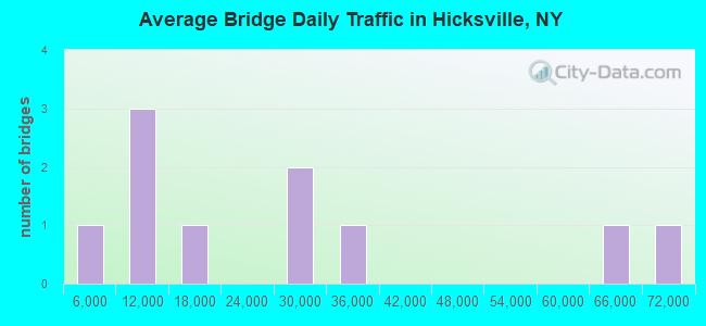
- 253,731Total average daily traffic
- 129Total average daily truck traffic
- National Bridge Inventory (NBI) Registered Bridges for Hicksville
- No street view available for this location
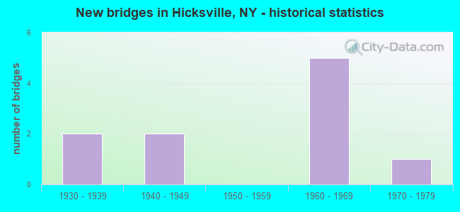
- New bridges - historical statistics
- 21930-1939
- 21940-1949
- 51960-1969
- 11970-1979
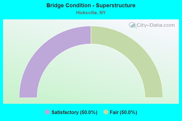
- Bridge Condition - Superstructure
- 50.0%Satisfactory
- 50.0%Fair
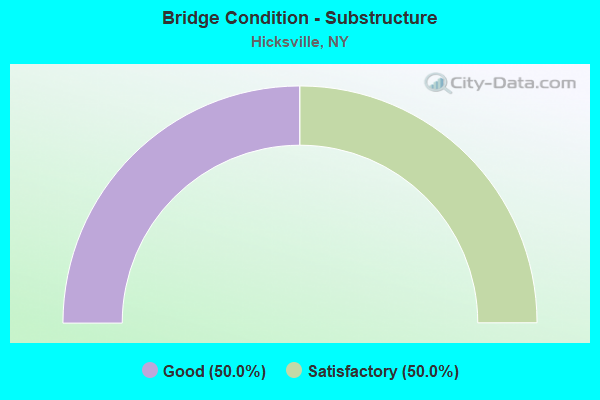
- Bridge Condition - Substructure
- 50.0%Good
- 50.0%Satisfactory
Find on map >> Show street view
Structure Number: 1058229, Location: 1.2 MI E NSP+WSP (Lat: 40.774886, Lng: -73.544689), Route carried "on" structure: State highway 908G, Year Built: 1947, Status: Open, Structure Length: 1.58m (5.18ft), Average Daily Traffic: 66,940 (year 2020), Average Future Daily Traffic: 79,625 (year 2040), Design Load: H 20, Features Intersected: PED PARK ROAD
Minimum Vertical Clearance: 30+ m (98+ ft), Kilometerpoint: 17.715, Lanes on structure: 4, Lanes under structure: 2, Base Highway Network: Yes, Owner: State Highway Agency, Approaching Roadway Width: 19.2m (63.0ft), Skew: 22 degrees, Material/Design: Concrete, Design/Construction: Frame, Number Of Spans In Main Unit: 1, Length of Maximum Span: 13.7m (44.9ft), Curb-To-Curb Width: 19.1m (62.7ft), Out-to-Out Width: 21.9m (71.9ft)
Condition: Deck: Good, Superstructure: Satisfactory, Substructure: Good, Operating Rating: 35.4 metric tons, Method Used To Determine Operating Rating: Load Factor (LF), Inventory Rating: 20.9 metric tons, Method Used To Determine Inventory Rating: Load Factor (LF), Structural Evaluation: Somewhat better than minimum adequacy, Deck Geometry: Somewhat better than minimum adequacy, Underclear: Equal to present minimum criteria, Approach Roadway Alignment: Equal to present desirable criteria, Length Of Structure Improvement: 1.58m (5.18ft), Designated Inspection Frequency: Every 24 months, Inspection Date: Febuary 2020, Bridge Improvement Cost: $2,200,000, Roadway Improvement Cost: $1,289,000, Total Project Cost: $3,489,000 ( Estimate for 2021), Wearing Surface/Protective System: Wearing Surface: Bituminous
Find on map >> Show street view
Structure Number: 105859, Location: 1.3 MI N JCT SH 106 & WSP (Lat: 40.748269, Lng: -73.547500), Route carried "on" structure: County highway , Year Built: 1938, Status: Open, Structure Length: 2.56m (8.40ft), Average Daily Traffic: 6,479 (year 2020), Truck Traffic: 2%, Average Future Daily Traffic: 7,870 (year 2040), Design Load: H 20, Features Intersected: 908T908T03011110 SB, RTE, Facility Carried by Structure: STEWART AVENUE
Minimum Vertical Clearance: 30+ m (98+ ft), Kilometerpoint: 2.478, Lanes on structure: 4, Lanes under structure: 4, Owner: State Highway Agency, Approaching Roadway Width: 12.2m (40.0ft), Skew: 1 degrees, Material/Design: Concrete, Design/Construction: Arch - Deck, Number Of Spans In Main Unit: 1, Length of Maximum Span: 22.8m (74.8ft), Curb or Sidewalk Widths: Left: 1.4m (4.6ft), Right: 1.4m (4.6ft), Curb-To-Curb Width: 12.2m (40.0ft), Out-to-Out Width: 16.2m (53.1ft)
Condition: Superstructure: Fair, Substructure: Satisfactory, Operating Rating: 57.9 metric tons, Method Used To Determine Operating Rating: Field evaluation and documented engineering judgment, Inventory Rating: 14.3 metric tons, Method Used To Determine Inventory Rating: Field evaluation and documented engineering judgment, Structural Evaluation: High priority of corrective action, Deck Geometry: High priority of replacement, Underclear: High priority of corrective action, Approach Roadway Alignment: Equal to present desirable criteria, Length Of Structure Improvement: 2.56m (8.40ft), Designated Inspection Frequency: Every 24 months, Inspection Date: June 2021, Bridge Improvement Cost: $3,201,000, Roadway Improvement Cost: $1,875,000, Total Project Cost: $5,076,000 ( Estimate for 2021), Wearing Surface/Protective System: Wearing Surface: Bituminous
Find on map >> Show street view
Structure Number: 1058229, Location: 1.2 MI E NSP+WSP (Lat: 40.774886, Lng: -73.544689), Route carried "under" structure: Other road , Year Built: 1947, Structure Length: 0. m, Average Daily Traffic: 10 (year 2021), Features Intersected: PED PARK ROAD, Facility Carried by Structure: RTE 908G
Minimum Vertical Clearance: 4.75m (15.58ft), Kilometerpoint: 0.000, Lanes on structure: 4, Lanes under structure: 2, Material/Design: Concrete, Design/Construction: Frame, Length of Maximum Span: 13.7m (44.9ft)
Find on map >> Show street view
Structure Number: 105859, Location: 1.3 MI N JCT SH 106 & WSP (Lat: 40.748269, Lng: -73.547500), Route carried "under" structure: State highway 908T, Year Built: 1938, Structure Length: 0. m, Average Daily Traffic: 63,859 (year 2002), Features Intersected: 908T908T03011110 SB, RTE, Facility Carried by Structure: STEWART AVENUE
Minimum Vertical Clearance: 4.62m (15.16ft), Kilometerpoint: 18.101, Lanes on structure: 4, Lanes under structure: 2, Material/Design: Concrete, Design/Construction: Arch - Deck, Length of Maximum Span: 22.8m (74.8ft)
Find on map >> Show street view
Structure Number: 703678, Location: 1.5 MI S OF RTE 495 (Lat: 40.768133, Lng: -73.524506), Route carried "under" structure: State highway 107, Year Built: 1963, Structure Length: 0. m, Average Daily Traffic: 28,672 (year 2002), Features Intersected: RTE 106, RTE 107, Facility Carried by Structure: LIRR MAIN LINE
Minimum Vertical Clearance: 4.41m (14.47ft), Kilometerpoint: 12.550, Lanes under structure: 16, Material/Design: Concrete continuous, Design/Construction: Slab, Length of Maximum Span: 31.3m (102.7ft)
Find on map >> Show street view
Structure Number: 703678, Location: 1.5 MI S OF RTE 495 (Lat: 40.768133, Lng: -73.524506), Route carried "under" structure: State highway 106, Year Built: 1963, Structure Length: 0. m, Average Daily Traffic: 30,771 (year 2002), Features Intersected: RTE 106, RTE 107, Facility Carried by Structure: LIRR MAIN LINE
Minimum Vertical Clearance: 4.41m (14.47ft), Kilometerpoint: 8.866, Lanes under structure: 16, Material/Design: Concrete continuous, Design/Construction: Slab, Length of Maximum Span: 31.3m (102.7ft)
Find on map >> Show street view
Structure Number: 703678A, Location: 1.5 MI S OF RTE 495 (Lat: 40.769639, Lng: -73.521717), Route carried "under" structure: Other road , Year Built: 1963, Structure Length: 0. m, Average Daily Traffic: 7,500 (year 1978), Features Intersected: BARCLAY STREET, BAY AVE, Facility Carried by Structure: LIRR PT JEFF BR
Minimum Vertical Clearance: 4.36m (14.30ft), Kilometerpoint: 0.000, Lanes under structure: 7, Material/Design: Concrete continuous, Design/Construction: Slab, Length of Maximum Span: 27.1m (88.9ft)
Find on map >> Show street view
Structure Number: 77092, Location: 1.4 MI WEST OF HICKSVILLE (Lat: 40.762442, Lng: -73.548222), Route carried "under" structure: Other road , Year Built: 1972, Structure Length: 0. m, Average Daily Traffic: 13,500 (year 1977), Features Intersected: CHARLOTTE ST, Facility Carried by Structure: LIRR MAIN LINE
Minimum Vertical Clearance: 4.59m (15.06ft), Kilometerpoint: 0.000, Lanes under structure: 4, Material/Design: Concrete, Design/Construction: Box Beam or Girders - Multiple, Length of Maximum Span: 20.1m (65.9ft)
Find on map >> Show street view
Structure Number: 770921, Location: 0.6 MI EAST OF HICKSVILLE (Lat: 40.764900, Lng: -73.516928), Route carried "under" structure: County highway , Year Built: 1963, Structure Length: 0. m, Average Daily Traffic: 27,500 (year 1977), Features Intersected: OLD COUNTRY RD, Facility Carried by Structure: LIRR MAIN LINE
Minimum Vertical Clearance: 4.36m (14.30ft), Kilometerpoint: 0.000, Lanes under structure: 4, Material/Design: Steel, Design/Construction: Girder and Floorbeam System, Length of Maximum Span: 30.4m (99.7ft)
Find on map >> Show street view
Structure Number: 77095, Location: 0.8 MI NE OF HICKSVILLE (Lat: 40.773908, Lng: -73.519575), Route carried "under" structure: Other road , Year Built: 1963, Structure Length: 0. m, Average Daily Traffic: 8,500 (year 1977), Features Intersected: BETHPAGE RD, Facility Carried by Structure: LIRR PT JEFF BR
Minimum Vertical Clearance: 4.34m (14.24ft), Kilometerpoint: 0.000, Lanes under structure: 4, Material/Design: Steel, Design/Construction: Girder and Floorbeam System, Length of Maximum Span: 28.6m (93.8ft)