Bridge Statistics for Hesperia, Michigan (MI)
Condition, Traffic, Stress, Structural Evaluation, Project Costs
- National Bridge Inventory (NBI) Statistics
- 13Number of bridges
- 89ft / 27.2mTotal length
- $150,000Total costs
- 17,825Total average daily traffic
- 779Total average daily truck traffic
- 24,838Total future (year 2018) average daily traffic
- National Bridge Inventory (NBI) Registered Bridges for Hesperia
- No street view available for this location
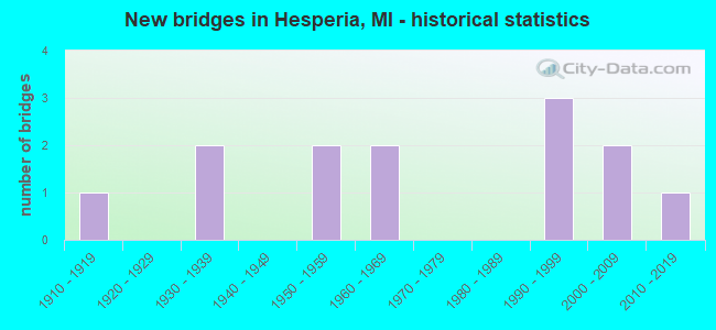
- New bridges - historical statistics
- 11910-1919
- 21930-1939
- 21950-1959
- 21960-1969
- 31990-1999
- 22000-2009
- 12010-2019

- Reconstructed bridges - Historical Statistics
- 11960-1969
- 01970-1979
- 01980-1989
- 01990-1999
- 02000-2009
- 22010-2019


- Bridge Condition - Deck
- 33.3%Very good
- 41.7%Good
- 16.7%Satisfactory
- 8.3%Fair

- Bridge Condition - Superstructure
- 33.3%Very good
- 33.3%Good
- 16.7%Satisfactory
- 16.7%Fair

- Bridge Condition - Substructure
- 25.0%Very good
- 33.3%Good
- 16.7%Satisfactory
- 25.0%Fair

- Bridge Condition - Channel
- 30.8%Good
- 61.5%Satisfactory
- 7.7%Fair
Find on map >> Show street view
Structure Number: 7717, Location: 4.7 MI S OF HESPERIA (Lat: 43.504467, Lng: -86.039556), Route carried "on" structure: State highway 120, Year Built: 1935, Status: Open, Structure Length: 0.94m (3.08ft), Average Daily Traffic: 5,638 (year 2007), Truck Traffic: 6%, Average Future Daily Traffic: 8,134 (year 2018), Design Load: H 15, Features Intersected: BRATON CREEK
Minimum Vertical Clearance: 30.48m (100.00ft), Kilometerpoint: 4.112, Lanes on structure: 2, Base Highway Network: Yes (Inventory Route: 154, Subroute: 10), Owner: State Highway Agency, Approaching Roadway Width: 15.5m (50.9ft), Material/Design: Concrete, Design/Construction: Tee Beam, Number Of Spans In Main Unit: 1, Length of Maximum Span: 9.4m (30.8ft), Curb or Sidewalk Widths: Left: 0.1m (0.3ft), Right: 0.1m (0.3ft), Curb-To-Curb Width: 11.0m (36.1ft), Out-to-Out Width: 11.6m (38.1ft)
Condition: Deck: Good, Superstructure: Good, Substructure: Good, Channel: Good, Operating Rating: 67.1 metric tons, Method Used To Determine Operating Rating: Load Factor (LF) rating reported by rating factor (RF) method using MS18 loading, Inventory Rating: 40.2 metric tons, Method Used To Determine Inventory Rating: Load Factor (LF) rating reported by rating factor (RF) method using MS18 loading, Structural Evaluation: Better than present minimum criteria, Deck Geometry: Meets minimum limits, Waterway Adequacy: High priority of corrective action, Approach Roadway Alignment: Equal to present desirable criteria, Designated Inspection Frequency: Every 24 months, Inspection Date: June 2020, Deck Structure Type: Concrete Cast-file-Place, Wearing Surface/Protective System: Wearing Surface: Bituminous
Find on map >> Show street view
Structure Number: 7743, Location: 2.0 MILE NE OF HESPERIA (Lat: 43.582008, Lng: -86.019533), Route carried "on" structure: County highway 6205, Year Built: 1962, Year Reconstructed: 1971, Status: Open, Structure Length: 3.56m (11.68ft), Average Daily Traffic: 1,300 (year 2000), Truck Traffic: 1%, Average Future Daily Traffic: 1,600 (year 2020), Design Load: H 20, Features Intersected: WHITE RIVER, Facility Carried by Structure: DICKINSON AVE FH32
Minimum Vertical Clearance: 30.48m (100.00ft), Kilometerpoint: 8.720, Lanes on structure: 2, Owner: County Highway Agency, Approaching Roadway Width: 8.5m (27.9ft), Skew: 4 degrees, Material/Design: Steel, Design/Construction: Stringer/Multi-beam, Number Of Spans In Main Unit: 3, Length of Maximum Span: 12.2m (40.0ft), Curb-To-Curb Width: 8.5m (27.9ft), Out-to-Out Width: 8.6m (28.2ft)
Condition: Deck: Fair, Superstructure: Fair, Substructure: Fair, Channel: Satisfactory, Operating Rating: 31.8 metric tons, Method Used To Determine Operating Rating: Load and Resistance Factor Rating (LRFR) rating reported by rating factor(RF) method using HL-93 loadings, Inventory Rating: 24.3 metric tons, Method Used To Determine Inventory Rating: Load and Resistance Factor Rating (LRFR) rating reported by rating factor(RF) method using HL-93 loadings, Structural Evaluation: Somewhat better than minimum adequacy, Deck Geometry: Somewhat better than minimum adequacy, Waterway Adequacy: Equal to present desirable criteria, Approach Roadway Alignment: Equal to present desirable criteria, Designated Inspection Frequency: Every 24 months, Inspection Date: June 2020, Deck Structure Type: Concrete Cast-file-Place, Wearing Surface/Protective System: Wearing Surface: Monolithic Concrete
Find on map >> Show street view
Structure Number: 7744, Location: 4.2 MI NE OF HESPERIA (Lat: 43.583133, Lng: -85.979958), Route carried "on" structure: County highway 6215, Year Built: 1957, Year Reconstructed: 2010, Status: Open, Structure Length: 2.43m (7.97ft), Average Daily Traffic: 1,000 (year 2010), Truck Traffic: 3%, Average Future Daily Traffic: 1,500 (year 2030), Features Intersected: WHITE RIVER, Facility Carried by Structure: GREEN AVE
Minimum Vertical Clearance: 30.48m (100.00ft), Kilometerpoint: 2.469, Lanes on structure: 2, Owner: County Highway Agency, Approaching Roadway Width: 9.4m (30.8ft), Material/Design: Prestressed concrete, Design/Construction: Box Beam or Girders - Single/Spread, Number Of Spans In Main Unit: 2, Length of Maximum Span: 12.2m (40.0ft), Curb-To-Curb Width: 7.3m (24.0ft), Out-to-Out Width: 8.9m (29.2ft)
Condition: Deck: Very good, Superstructure: Very good, Substructure: Good, Channel: Good, Operating Rating: 75.2 metric tons, Method Used To Determine Operating Rating: Load and Resistance Factor Rating (LRFR) rating reported by rating factor(RF) method using HL-93 loadings, Inventory Rating: 58.0 metric tons, Method Used To Determine Inventory Rating: Load and Resistance Factor Rating (LRFR) rating reported by rating factor(RF) method using HL-93 loadings, Structural Evaluation: Better than present minimum criteria, Deck Geometry: Meets minimum limits, Waterway Adequacy: Better than present minimum criteria, Approach Roadway Alignment: Better than present minimum criteria, Designated Inspection Frequency: Every 24 months, Inspection Date: June 2020, Deck Structure Type: Concrete Cast-file-Place, Wearing Surface/Protective System: Wearing Surface: Monolithic Concrete, Deck Protection: Epoxy Coated Reinforcing
Find on map >> Show street view
Structure Number: 776, Location: 1 MI NE OF HESPERIA (Lat: 43.579853, Lng: -86.010183), Route carried "on" structure: Spur County highway , Year Built: 1994, Status: Open, Structure Length: 2.98m (9.78ft), Average Daily Traffic: 700 (year 2000), Average Future Daily Traffic: 1,000 (year 2020), Design Load: HS 20, Features Intersected: WHITE RIVER, Facility Carried by Structure: FITZGERALD AVE
Minimum Vertical Clearance: 30.48m (100.00ft), Kilometerpoint: 0.476, Lanes on structure: 2, Owner: County Highway Agency, Approaching Roadway Width: 6.1m (20.0ft), Material/Design: Steel, Design/Construction: Truss - Thru, Number Of Spans In Main Unit: 1, Length of Maximum Span: 28.6m (93.8ft), Curb-To-Curb Width: 7.3m (24.0ft), Out-to-Out Width: 7.4m (24.3ft)
Condition: Deck: Good, Superstructure: Good, Substructure: Good, Channel: Good, Operating Rating: 44.7 metric tons, Method Used To Determine Operating Rating: Load and Resistance Factor Rating (LRFR) rating reported by rating factor(RF) method using HL-93 loadings, Inventory Rating: 34.7 metric tons, Method Used To Determine Inventory Rating: Load and Resistance Factor Rating (LRFR) rating reported by rating factor(RF) method using HL-93 loadings, Structural Evaluation: Better than present minimum criteria, Deck Geometry: Meets minimum limits, Waterway Adequacy: Equal to present minimum criteria, Approach Roadway Alignment: Equal to present minimum criteria, Designated Inspection Frequency: Every 24 months, Critical Feature Inspection Frequency: Every 24 months, Inspection Date: June 2020, Critical Feature Inspection Date: June 2020, Deck Structure Type: Wood or Timber, Wearing Surface/Protective System: Wearing Surface: Bituminous, Membrane: Preformed Fabric
Find on map >> Show street view
Structure Number: 7762, Location: 5.0 MI NW OF HESPERIA (Lat: 43.590367, Lng: -85.972217), Route carried "on" structure: County highway , Year Built: 1998, Status: Open, Structure Length: 0.79m (2.59ft), Average Daily Traffic: 150 (year 2000), Average Future Daily Traffic: 200 (year 2020), Design Load: HS 20, Features Intersected: MARTIN CREEK, Facility Carried by Structure: MONROE ST
Minimum Vertical Clearance: 30.48m (100.00ft), Kilometerpoint: 0.618, Lanes on structure: 2, Owner: County Highway Agency, Approaching Roadway Width: 8.5m (27.9ft), Material/Design: Concrete, Design/Construction: Culvert, Number Of Spans In Main Unit: 1, Length of Maximum Span: 7.3m (24.0ft), Out-to-Out Width: 9.8m (32.2ft)
Condition: Channel: Satisfactory, Culverts: Good, Operating Rating: 43.7 metric tons, Method Used To Determine Operating Rating: Load Factor (LF) rating reported by rating factor (RF) method using MS18 loading, Inventory Rating: 26.2 metric tons, Method Used To Determine Inventory Rating: Load Factor (LF) rating reported by rating factor (RF) method using MS18 loading, Structural Evaluation: Equal to present minimum criteria, Waterway Adequacy: Equal to present minimum criteria, Approach Roadway Alignment: Equal to present minimum criteria, Designated Inspection Frequency: Every 24 months, Inspection Date: June 2020
Find on map >> Show street view
Structure Number: 8363, Location: 0.8 MI W OF NEWAYGO COL (Lat: 43.567739, Lng: -86.053431), Route carried "on" structure: State highway 20, Year Built: 1963, Status: Open, Structure Length: 2.74m (8.99ft), Average Daily Traffic: 3,067 (year 2007), Truck Traffic: 7%, Average Future Daily Traffic: 4,044 (year 2018), Design Load: HS 20, Features Intersected: WHITE RIVER
Minimum Vertical Clearance: 30.48m (100.00ft), Kilometerpoint: 36.603, Lanes on structure: 2, Base Highway Network: Yes (Inventory Route: 364, Subroute: 72), Owner: State Highway Agency, Approaching Roadway Width: 13.4m (44.0ft), Material/Design: Prestressed concrete, Design/Construction: Stringer/Multi-beam, Number Of Spans In Main Unit: 2, Length of Maximum Span: 13.7m (44.9ft), Curb or Sidewalk Widths: Left: 0.1m (0.3ft), Right: 0.1m (0.3ft), Curb-To-Curb Width: 13.7m (44.9ft), Out-to-Out Width: 14.4m (47.2ft)
Condition: Deck: Satisfactory, Superstructure: Satisfactory, Substructure: Very good, Channel: Satisfactory, Operating Rating: 52.8 metric tons, Method Used To Determine Operating Rating: Load Factor (LF) rating reported by rating factor (RF) method using MS18 loading, Inventory Rating: 31.8 metric tons, Method Used To Determine Inventory Rating: Load Factor (LF) rating reported by rating factor (RF) method using MS18 loading, Structural Evaluation: Equal to present minimum criteria, Deck Geometry: Superior to present desirable criteria, Waterway Adequacy: Equal to present desirable criteria, Approach Roadway Alignment: Better than present minimum criteria, Designated Inspection Frequency: Every 24 months, Underwater Inspection Frequency: Every 60 months, Inspection Date: April 2020, Underwater Inspection Date: May 2020, Deck Structure Type: Concrete Cast-file-Place, Wearing Surface/Protective System: Wearing Surface: Monolithic Concrete
Find on map >> Show street view
Structure Number: 8367, Location: 2.5 MI SW OF HESPERIA (Lat: 43.554469, Lng: -86.074864), Route carried "on" structure: County highway 6491, Year Built: 1950, Status: Open, Structure Length: 1.82m (5.97ft), Average Daily Traffic: 1,950 (year 2004), Average Future Daily Traffic: 2,200 (year 2024), Design Load: HS 20, Features Intersected: SOUTH BRANCH WHITE RIVER, Facility Carried by Structure: GARFIELD ROAD
Minimum Vertical Clearance: 30.48m (100.00ft), Kilometerpoint: 20.111, Lanes on structure: 2, Owner: County Highway Agency, Approaching Roadway Width: 9.1m (29.9ft), Material/Design: Steel, Design/Construction: Stringer/Multi-beam, Number Of Spans In Main Unit: 1, Length of Maximum Span: 17.6m (57.7ft), Curb-To-Curb Width: 9.4m (30.8ft), Out-to-Out Width: 11.1m (36.4ft)
Condition: Deck: Satisfactory, Superstructure: Satisfactory, Substructure: Satisfactory, Channel: Fair, Operating Rating: 58.0 metric tons, Method Used To Determine Operating Rating: Load Factor (LF) rating reported by rating factor (RF) method using MS18 loading, Inventory Rating: 34.7 metric tons, Method Used To Determine Inventory Rating: Load Factor (LF) rating reported by rating factor (RF) method using MS18 loading, Structural Evaluation: Equal to present minimum criteria, Deck Geometry: Somewhat better than minimum adequacy, Waterway Adequacy: Equal to present minimum criteria, Approach Roadway Alignment: Better than present minimum criteria, Designated Inspection Frequency: Every 24 months, Inspection Date: August 2020, Deck Structure Type: Concrete Cast-file-Place, Wearing Surface/Protective System: Wearing Surface: Bituminous
Find on map >> Show street view
Structure Number: 8378, Location: 3.0 MI SW OF HESPERIA (Lat: 43.539208, Lng: -86.078625), Route carried "on" structure: County highway 6491, Year Built: 1931, Status: Open, Structure Length: 0.85m (2.79ft), Average Daily Traffic: 990 (year 2005), Average Future Daily Traffic: 1,600 (year 2025), Design Load: HS 20, Features Intersected: BRATON CREEK, Facility Carried by Structure: 194TH AVE
Minimum Vertical Clearance: 30.48m (100.00ft), Kilometerpoint: 0.171, Lanes on structure: 2, Owner: County Highway Agency, Approaching Roadway Width: 10.4m (34.1ft), Material/Design: Steel, Design/Construction: Stringer/Multi-beam, Number Of Spans In Main Unit: 1, Length of Maximum Span: 7.9m (25.9ft), Curb-To-Curb Width: 9.8m (32.2ft), Out-to-Out Width: 17.9m (58.7ft)
Condition: Deck: Good, Superstructure: Fair, Substructure: Fair, Channel: Satisfactory, Operating Rating: 75.5 metric tons, Method Used To Determine Operating Rating: Load Factor (LF) rating reported by rating factor (RF) method using MS18 loading, Inventory Rating: 45.4 metric tons, Method Used To Determine Inventory Rating: Load Factor (LF) rating reported by rating factor (RF) method using MS18 loading, Structural Evaluation: Somewhat better than minimum adequacy, Deck Geometry: Equal to present minimum criteria, Waterway Adequacy: Equal to present minimum criteria, Approach Roadway Alignment: High priority of corrective action, Designated Inspection Frequency: Every 24 months, Inspection Date: August 2020, Deck Structure Type: Concrete Cast-file-Place
Find on map >> Show street view
Structure Number: 8396, Location: 1.0 MI E OF 192ND AVENUE (Lat: 43.565131, Lng: -86.058322), Route carried "on" structure: County highway , Year Built: 1994, Status: Open, Structure Length: 2.43m (7.97ft), Average Daily Traffic: 480 (year 2004), Truck Traffic: 10%, Average Future Daily Traffic: 800 (year 2025), Design Load: HS 20+Mod, Features Intersected: WHITE RIVER, Facility Carried by Structure: HAWLEY RD
Minimum Vertical Clearance: 30.48m (100.00ft), Kilometerpoint: 1.672, Lanes on structure: 2, Owner: County Highway Agency, Approaching Roadway Width: 8.5m (27.9ft), Material/Design: Prestressed concrete, Design/Construction: Box Beam or Girders - Multiple, Number Of Spans In Main Unit: 1, Length of Maximum Span: 23.1m (75.8ft), Curb or Sidewalk Widths: Left: 1.7m (5.6ft), Right: 1.7m (5.6ft), Curb-To-Curb Width: 9.1m (29.9ft), Out-to-Out Width: 13.4m (44.0ft)
Condition: Deck: Good, Superstructure: Good, Substructure: Very good, Channel: Satisfactory, Operating Rating: 71.0 metric tons, Method Used To Determine Operating Rating: Load Factor (LF) rating reported by rating factor (RF) method using MS18 loading, Inventory Rating: 42.4 metric tons, Method Used To Determine Inventory Rating: Load Factor (LF) rating reported by rating factor (RF) method using MS18 loading, Structural Evaluation: Better than present minimum criteria, Deck Geometry: Equal to present minimum criteria, Waterway Adequacy: Equal to present desirable criteria, Approach Roadway Alignment: Equal to present desirable criteria, Designated Inspection Frequency: Every 24 months, Inspection Date: August 2020, Deck Structure Type: Concrete Cast-file-Place, Wearing Surface/Protective System: Wearing Surface: Bituminous, Membrane: Other, Deck Protection: Epoxy Coated Reinforcing
Find on map >> Show street view
Structure Number: 841, Location: IN HESPERIA (Lat: 43.572306, Lng: -86.043411), Route carried "on" structure: City street , Year Built: 2006, Status: Open, Structure Length: 2.53m (8.30ft), Average Daily Traffic: 1,000 (year 2002), Truck Traffic: 3%, Average Future Daily Traffic: 1,800 (year 2025), Design Load: HS 25 or greater, Features Intersected: WHITE RIVER, Facility Carried by Structure: MICHIGAN STREET
Minimum Vertical Clearance: 30.48m (100.00ft), Kilometerpoint: 2.874, Lanes on structure: 2, Owner: City or Municipal Highway Agency, Approaching Roadway Width: 8.8m (28.9ft), Material/Design: Prestressed concrete, Design/Construction: Box Beam or Girders - Single/Spread, Number Of Spans In Main Unit: 1, Length of Maximum Span: 24.1m (79.1ft), Curb or Sidewalk Widths: Left: 1.7m (5.6ft), Right: 1.7m (5.6ft), Curb-To-Curb Width: 7.9m (25.9ft), Out-to-Out Width: 12.3m (40.4ft)
Condition: Deck: Very good, Superstructure: Very good, Substructure: Satisfactory, Channel: Satisfactory, Operating Rating: 87.2 metric tons, Method Used To Determine Operating Rating: Load and Resistance Factor Rating (LRFR) rating reported by rating factor(RF) method using HL-93 loadings, Inventory Rating: 51.2 metric tons, Method Used To Determine Inventory Rating: Load and Resistance Factor Rating (LRFR) rating reported by rating factor(RF) method using HL-93 loadings, Structural Evaluation: Equal to present minimum criteria, Deck Geometry: Somewhat better than minimum adequacy, Waterway Adequacy: Equal to present minimum criteria, Approach Roadway Alignment: Meets minimum limits, Designated Inspection Frequency: Every 24 months, Inspection Date: October 2021, Deck Structure Type: Concrete Cast-file-Place, Wearing Surface/Protective System: Wearing Surface: Integral Concrete, Deck Protection: Epoxy Coated Reinforcing
Find on map >> Show street view
Structure Number: 8411, Location: IN HESPERIA (Lat: 43.572611, Lng: -86.039653), Route carried "on" structure: City street , Year Built: 2003, Status: Open, Structure Length: 3.66m (12.01ft), Average Daily Traffic: 1,100 (year 2003), Truck Traffic: 6%, Average Future Daily Traffic: 1,400 (year 2023), Design Load: HS 20+Mod, Features Intersected: WHITE RIVER, Facility Carried by Structure: DIVISION STREET
Minimum Vertical Clearance: 30.48m (100.00ft), Kilometerpoint: 11.708, Lanes on structure: 2, Owner: City or Municipal Highway Agency, Approaching Roadway Width: 9.8m (32.2ft), Material/Design: Prestressed concrete, Design/Construction: Box Beam or Girders - Multiple, Number Of Spans In Main Unit: 2, Length of Maximum Span: 18.3m (60.0ft), Curb or Sidewalk Widths: Left: 1.5m (4.9ft), Right: 1.5m (4.9ft), Curb-To-Curb Width: 9.8m (32.2ft), Out-to-Out Width: 13.4m (44.0ft)
Condition: Deck: Good, Superstructure: Good, Substructure: Good, Channel: Good, Operating Rating: 49.9 metric tons, Method Used To Determine Operating Rating: Load and Resistance Factor Rating (LRFR) rating reported by rating factor(RF) method using HL-93 loadings, Inventory Rating: 38.6 metric tons, Method Used To Determine Inventory Rating: Load and Resistance Factor Rating (LRFR) rating reported by rating factor(RF) method using HL-93 loadings, Structural Evaluation: Better than present minimum criteria, Deck Geometry: Somewhat better than minimum adequacy, Waterway Adequacy: Somewhat better than minimum adequacy, Approach Roadway Alignment: Equal to present desirable criteria, Designated Inspection Frequency: Every 24 months, Inspection Date: October 2021, Deck Structure Type: Concrete Precast Panels, Wearing Surface/Protective System: Wearing Surface: Monolithic Concrete, Deck Protection: Epoxy Coated Reinforcing
Find on map >> Show street view
Structure Number: 12969, Location: GREENWOOD TWP SEC 13 & 14 (Lat: 43.520267, Lng: -86.059681), Route carried "on" structure: County highway , Year Built: 1915, Year Reconstructed: 2015, Status: Open, Structure Length: 0.79m (2.59ft), Average Daily Traffic: 50 (year 2000), Truck Traffic: 1%, Average Future Daily Traffic: 60 (year 2020), Design Load: H 10, Features Intersected: BRAYTON CREEK, Facility Carried by Structure: 200TH AVE
Minimum Vertical Clearance: 30.48m (100.00ft), Kilometerpoint: 5.897, Lanes on structure: 2, Owner: County Highway Agency, Approaching Roadway Width: 4.9m (16.1ft), Material/Design: Wood or Timber, Design/Construction: Slab, Number Of Spans In Main Unit: 1, Length of Maximum Span: 6.7m (22.0ft), Curb-To-Curb Width: 4.9m (16.1ft), Out-to-Out Width: 5.3m (17.4ft)
Condition: Deck: Very good, Superstructure: Very good, Substructure: Fair, Channel: Satisfactory, Operating Rating: 42.1 metric tons, Method Used To Determine Operating Rating: Load and Resistance Factor Rating (LRFR) rating reported by rating factor(RF) method using HL-93 loadings, Inventory Rating: 30.1 metric tons, Method Used To Determine Inventory Rating: Load and Resistance Factor Rating (LRFR) rating reported by rating factor(RF) method using HL-93 loadings, Structural Evaluation: Somewhat better than minimum adequacy, Deck Geometry: High priority of corrective action, Waterway Adequacy: Equal to present minimum criteria, Approach Roadway Alignment: Equal to present minimum criteria, Length Of Structure Improvement: 1.20m (3.94ft), Designated Inspection Frequency: Every 24 months, Inspection Date: August 2020, Bridge Improvement Cost: $100,000, Roadway Improvement Cost: $50,000, Total Project Cost: $150,000, Deck Structure Type: Wood or Timber, Wearing Surface/Protective System: Wearing Surface: Wood or Timber
Find on map >> Show street view
Structure Number: 13976, Location: 0.18 MI W OF 200TH AVE (Lat: 43.525306, Lng: -86.063111), Route carried "on" structure: County highway , Year Built: 2015, Status: Open, Structure Length: 1.65m (5.41ft), Average Daily Traffic: 400 (year 2016), Truck Traffic: 10%, Average Future Daily Traffic: 500 (year 2020), Design Load: HS 20, Features Intersected: BRAYTON CREEK, Facility Carried by Structure: CLEVELAND RD
Minimum Vertical Clearance: 30.48m (100.00ft), Kilometerpoint: 0.000, Lanes on structure: 2, Owner: County Highway Agency, Approaching Roadway Width: 7.9m (25.9ft), Material/Design: Wood or Timber, Design/Construction: Slab, Number Of Spans In Main Unit: 3, Length of Maximum Span: 7.9m (25.9ft), Curb-To-Curb Width: 7.9m (25.9ft), Out-to-Out Width: 8.3m (27.2ft)
Condition: Deck: Very good, Superstructure: Very good, Substructure: Very good, Channel: Satisfactory, Operating Rating: 36.9 metric tons, Method Used To Determine Operating Rating: Load and Resistance Factor Rating (LRFR) rating reported by rating factor(RF) method using HL-93 loadings, Inventory Rating: 25.9 metric tons, Method Used To Determine Inventory Rating: Load and Resistance Factor Rating (LRFR) rating reported by rating factor(RF) method using HL-93 loadings, Structural Evaluation: Equal to present minimum criteria, Deck Geometry: Somewhat better than minimum adequacy, Waterway Adequacy: Superior to present desirable criteria, Approach Roadway Alignment: Equal to present desirable criteria, Designated Inspection Frequency: Every 24 months, Inspection Date: August 2020, Deck Structure Type: Wood or Timber, Wearing Surface/Protective System: Wearing Surface: Bituminous