Bridge Statistics for Hereford, Texas (TX)
Condition, Traffic, Stress, Structural Evaluation, Project Costs
- National Bridge Inventory (NBI) Statistics
- 11Number of bridges
- 128ft / 38.5mTotal length
- $77,000Total costs
- 56,867Total average daily traffic
- 18,787Total average daily truck traffic
- 75,830Total future (year 2033) average daily traffic
- National Bridge Inventory (NBI) Registered Bridges for Hereford
- No street view available for this location
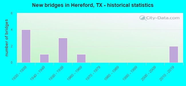
- New bridges - historical statistics
- 41930-1939
- 11940-1949
- 31950-1959
- 11960-1969
- 22010-2019
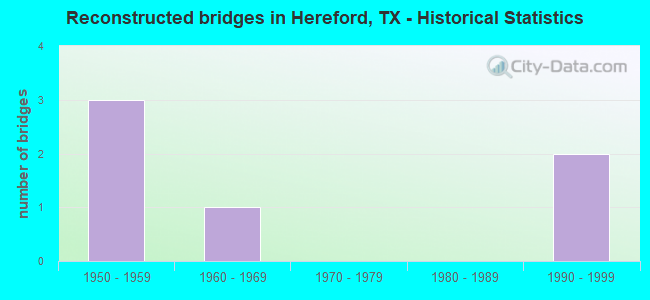
- Reconstructed bridges - Historical Statistics
- 31950-1959
- 11960-1969
- 01970-1979
- 01980-1989
- 21990-1999
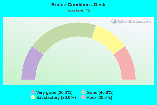
- Bridge Condition - Deck
- 20.0%Very good
- 40.0%Good
- 20.0%Satisfactory
- 20.0%Poor
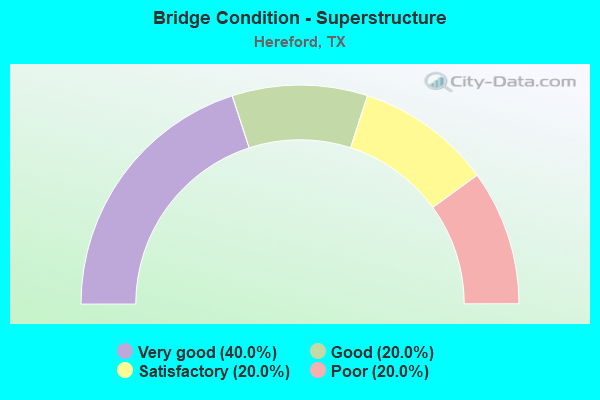
- Bridge Condition - Superstructure
- 40.0%Very good
- 20.0%Good
- 20.0%Satisfactory
- 20.0%Poor
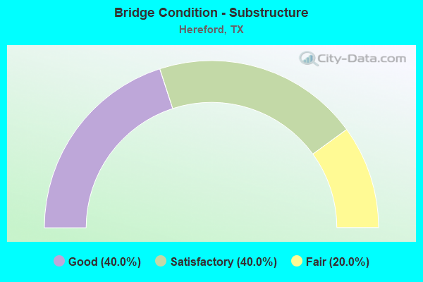
- Bridge Condition - Substructure
- 40.0%Good
- 40.0%Satisfactory
- 20.0%Fair
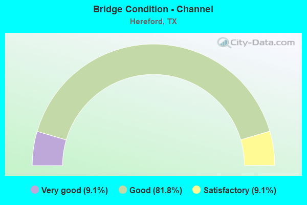
- Bridge Condition - Channel
- 9.1%Very good
- 81.8%Good
- 9.1%Satisfactory
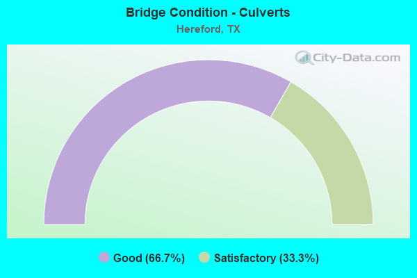
- Bridge Condition - Culverts
- 66.7%Good
- 33.3%Satisfactory
Find on map >> Show street view
Structure Number: 40590009001004, Location: 1.9 Mi E of State Line (Lat: 35.182553, Lng: -103.009586), Route carried "on" structure: Interstate 40, Year Built: 1938, Year Reconstructed: 2003, Status: Open, Structure Length: 0.85m (2.79ft), Average Daily Traffic: 11,800 (year 2013), Truck Traffic: 46%, Average Future Daily Traffic: 16,530 (year 2033), Design Load: H 15, Features Intersected: Draw
Minimum Vertical Clearance: 30+ m (98+ ft), Kilometerpoint: 4.619, Lanes on structure: 4, Owner: State Highway Agency, Approaching Roadway Width: 23.2m (76.1ft), Skew: 20 degrees, Material/Design: Concrete, Design/Construction: Culvert, Number Of Spans In Main Unit: 5, Length of Maximum Span: 1.5m (4.9ft)
Condition: Channel: Very good, Culverts: Good, Operating Rating: 32.7 metric tons, Method Used To Determine Operating Rating: Field evaluation and documented engineering judgment, Inventory Rating: 24.5 metric tons, Method Used To Determine Inventory Rating: Field evaluation and documented engineering judgment, Structural Evaluation: Equal to present minimum criteria, Waterway Adequacy: Superior to present desirable criteria, Approach Roadway Alignment: Equal to present desirable criteria, Length Of Structure Improvement: 0.85m (2.79ft), Designated Inspection Frequency: Every 24 months, Inspection Date: September 2021, Bridge Improvement Cost: $70,000, Roadway Improvement Cost: $7,000, Total Project Cost: $77,000
Find on map >> Show street view
Structure Number: 40590016805003, Location: 4.7 Mi W of US 385 (Lat: 34.764917, Lng: -102.461703), Route carried "on" structure: US 60, Year Built: 1935, Year Reconstructed: 1973, Status: Open, Structure Length: 0.79m (2.59ft), Average Daily Traffic: 5,775 (year 2019), Truck Traffic: 19%, Average Future Daily Traffic: 9,310 (year 2033), Features Intersected: Draw
Minimum Vertical Clearance: 30+ m (98+ ft), Kilometerpoint: 4.023, Lanes on structure: 7, Owner: State Highway Agency, Approaching Roadway Width: 31.7m (104.0ft), Material/Design: Concrete, Design/Construction: Culvert, Number Of Spans In Main Unit: 4, Length of Maximum Span: 1.8m (5.9ft)
Condition: Channel: Good, Culverts: Good, Operating Rating: 32.7 metric tons, Method Used To Determine Operating Rating: Field evaluation and documented engineering judgment, Inventory Rating: 24.5 metric tons, Method Used To Determine Inventory Rating: Field evaluation and documented engineering judgment, Structural Evaluation: Equal to present minimum criteria, Waterway Adequacy: Equal to present minimum criteria, Approach Roadway Alignment: Equal to present desirable criteria, Length Of Structure Improvement: 1.49m (4.89ft), Designated Inspection Frequency: Every 24 months, Inspection Date: November 2020
Find on map >> Show street view
Structure Number: 40590016805165, Location: 0.95 Mi SW of US 385 (Lat: 34.802228, Lng: -102.417994), Route carried "on" structure: US 60, Year Built: 2010, Status: Open, Structure Length: 7.32m (24.02ft), Average Daily Traffic: 9,589 (year 2020), Truck Traffic: 29%, Average Future Daily Traffic: 12,860 (year 2033), Design Load: HL 93, Features Intersected: Tierra Blanca Creek
Minimum Vertical Clearance: 30+ m (98+ ft), Kilometerpoint: 9.811, Lanes on structure: 5, Owner: State Highway Agency, Approaching Roadway Width: 26.2m (86.0ft), Material/Design: Prestressed concrete, Design/Construction: Stringer/Multi-beam, Number Of Spans In Main Unit: 3, Length of Maximum Span: 24.4m (80.1ft), Curb-To-Curb Width: 25.3m (83.0ft), Out-to-Out Width: 26.2m (86.0ft)
Condition: Deck: Good, Superstructure: Very good, Substructure: Good, Channel: Good, Operating Rating: 54.4 metric tons, Method Used To Determine Operating Rating: Assigned ratings based on Load and Resistance Factor Design (LRFD) reported in metric tons, Inventory Rating: 32.7 metric tons, Method Used To Determine Inventory Rating: Assigned ratings based on Load and Resistance Factor Design (LRFD) reported in metric tons, Structural Evaluation: Better than present minimum criteria, Deck Geometry: Superior to present desirable criteria, Waterway Adequacy: Superior to present desirable criteria, Approach Roadway Alignment: Equal to present desirable criteria, Length Of Structure Improvement: 7.32m (24.02ft), Designated Inspection Frequency: Every 24 months, Inspection Date: September 2021, Deck Structure Type: Concrete Precast Panels, Wearing Surface/Protective System: Wearing Surface: Epoxy Overlay
Find on map >> Show street view
Structure Number: 40590016807005, Location: 0.3 Mi E of FM 2943 (Lat: 34.838219, Lng: -102.349978), Route carried "on" structure: US 60, Year Built: 1934, Year Reconstructed: 1961, Status: Open, Structure Length: 0.85m (2.79ft), Average Daily Traffic: 11,485 (year 2020), Truck Traffic: 22%, Average Future Daily Traffic: 12,570 (year 2033), Features Intersected: Drain
Minimum Vertical Clearance: 30+ m (98+ ft), Kilometerpoint: 7.514, Lanes on structure: 4, Owner: State Highway Agency, Approaching Roadway Width: 24.7m (81.0ft), Skew: 20 degrees, Material/Design: Concrete, Design/Construction: Culvert, Number Of Spans In Main Unit: 5, Length of Maximum Span: 1.5m (4.9ft), Curb-To-Curb Width: 24.7m (81.0ft), Out-to-Out Width: 37.6m (123.4ft)
Condition: Channel: Good, Culverts: Good, Operating Rating: 32.7 metric tons, Method Used To Determine Operating Rating: Field evaluation and documented engineering judgment, Inventory Rating: 24.5 metric tons, Method Used To Determine Inventory Rating: Field evaluation and documented engineering judgment, Structural Evaluation: Equal to present minimum criteria, Deck Geometry: Superior to present desirable criteria, Waterway Adequacy: Equal to present minimum criteria, Approach Roadway Alignment: Equal to present desirable criteria, Designated Inspection Frequency: Every 24 months, Inspection Date: November 2020, Deck Structure Type: Concrete Cast-file-Place, Wearing Surface/Protective System: Wearing Surface: Bituminous
Find on map >> Show street view
Structure Number: 40590022605005, Location: 0.4 Mi S of US 60 (Lat: 34.804978, Lng: -102.405519), Route carried "on" structure: US 385, Year Built: 1939, Year Reconstructed: 1959, Status: Open, Structure Length: 5.33m (17.49ft), Average Daily Traffic: 7,156 (year 2020), Truck Traffic: 49%, Average Future Daily Traffic: 9,210 (year 2033), Design Load: H 15, Features Intersected: Tierra Blanca Creek
Minimum Vertical Clearance: 30+ m (98+ ft), Kilometerpoint: 43.776, Lanes on structure: 3, Owner: State Highway Agency, Approaching Roadway Width: 15.9m (52.2ft), Material/Design: Steel, Design/Construction: Stringer/Multi-beam, Number Of Spans In Main Unit: 5, Length of Maximum Span: 10.7m (35.1ft), Curb-To-Curb Width: 15.6m (51.2ft), Out-to-Out Width: 16.5m (54.1ft)
Condition: Deck: Satisfactory, Superstructure: Satisfactory, Substructure: Satisfactory, Channel: Satisfactory, Operating Rating: 46.3 metric tons, Method Used To Determine Operating Rating: Load Factor (LF), Inventory Rating: 27.2 metric tons, Method Used To Determine Inventory Rating: Load Factor (LF), Structural Evaluation: Equal to present minimum criteria, Deck Geometry: Equal to present minimum criteria, Waterway Adequacy: Equal to present minimum criteria, Approach Roadway Alignment: Equal to present desirable criteria, Bridge Posting: Required (Relationship of Operating Rating to Maximum Legal Load: 0.1 - 9.9% below), Designated Inspection Frequency: Every 24 months, Inspection Date: September 2021, Deck Structure Type: Concrete Cast-file-Place, Wearing Surface/Protective System: Wearing Surface: Bituminous
Find on map >> Show street view
Structure Number: 4059002260501, Location: 6.5 Mi S of FM 1062 (Lat: 34.889472, Lng: -102.404397), Route carried "on" structure: US 385, Year Built: 1947, Year Reconstructed: 1961, Status: Open, Structure Length: 1.19m (3.90ft), Average Daily Traffic: 3,957 (year 2020), Truck Traffic: 49%, Average Future Daily Traffic: 4,670 (year 2033), Features Intersected: Drain
Minimum Vertical Clearance: 30+ m (98+ ft), Kilometerpoint: 34.435, Lanes on structure: 2, Owner: State Highway Agency, Approaching Roadway Width: 13.4m (44.0ft), Skew: 3 degrees, Material/Design: Concrete, Design/Construction: Culvert, Number Of Spans In Main Unit: 5, Length of Maximum Span: 1.8m (5.9ft)
Condition: Channel: Good, Culverts: Satisfactory, Operating Rating: 32.7 metric tons, Method Used To Determine Operating Rating: Field evaluation and documented engineering judgment, Inventory Rating: 24.5 metric tons, Method Used To Determine Inventory Rating: Field evaluation and documented engineering judgment, Structural Evaluation: Equal to present minimum criteria, Waterway Adequacy: Equal to present minimum criteria, Approach Roadway Alignment: Equal to present desirable criteria, Designated Inspection Frequency: Every 24 months, Inspection Date: November 2020
Find on map >> Show street view
Structure Number: 4059002260502, Location: 4.35 MI S OF US 60 (Lat: 34.757056, Lng: -102.377117), Route carried "on" structure: State highway 385, Year Built: 2010, Status: Open, Structure Length: 7.32m (24.02ft), Average Daily Traffic: 3,171 (year 2020), Truck Traffic: 30%, Average Future Daily Traffic: 3,360 (year 2033), Design Load: HL 93, Features Intersected: Frio Draw
Minimum Vertical Clearance: 30+ m (98+ ft), Kilometerpoint: 50.210, Lanes on structure: 2, Owner: State Highway Agency, Approaching Roadway Width: 12.2m (40.0ft), Material/Design: Prestressed concrete, Design/Construction: Stringer/Multi-beam, Number Of Spans In Main Unit: 4, Length of Maximum Span: 18.3m (60.0ft), Curb-To-Curb Width: 13.3m (43.6ft), Out-to-Out Width: 14.0m (45.9ft)
Condition: Deck: Very good, Superstructure: Very good, Substructure: Good, Channel: Good, Operating Rating: 54.4 metric tons, Method Used To Determine Operating Rating: Assigned ratings based on Load and Resistance Factor Design (LRFD) reported in metric tons, Inventory Rating: 32.7 metric tons, Method Used To Determine Inventory Rating: Assigned ratings based on Load and Resistance Factor Design (LRFD) reported in metric tons, Structural Evaluation: Better than present minimum criteria, Deck Geometry: Equal to present minimum criteria, Waterway Adequacy: Equal to present minimum criteria, Approach Roadway Alignment: Equal to present desirable criteria, Length Of Structure Improvement: 7.32m (24.02ft), Designated Inspection Frequency: Every 24 months, Inspection Date: September 2021, Deck Structure Type: Concrete Precast Panels, Wearing Surface/Protective System: Wearing Surface: Bituminous
Find on map >> Show street view
Structure Number: 40590124301001, Location: 5.1 Mi W of SH 214 (Lat: 34.828347, Lng: -102.902478), Route carried "on" structure: State highway 1058, Year Built: 1950, Status: Open, Structure Length: 0.67m (2.20ft), Average Daily Traffic: 104 (year 2020), Truck Traffic: 45%, Average Future Daily Traffic: 160 (year 2033), Design Load: H 15, Features Intersected: Draw
Minimum Vertical Clearance: 30+ m (98+ ft), Kilometerpoint: 14.622, Lanes on structure: 2, Owner: State Highway Agency, Approaching Roadway Width: 7.9m (25.9ft), Material/Design: Concrete, Design/Construction: Culvert, Number Of Spans In Main Unit: 4, Length of Maximum Span: 1.5m (4.9ft), Curb-To-Curb Width: 12.8m (42.0ft), Out-to-Out Width: 13.2m (43.3ft)
Condition: Channel: Good, Culverts: Satisfactory, Operating Rating: 39.9 metric tons, Method Used To Determine Operating Rating: Load Factor (LF), Inventory Rating: 23.6 metric tons, Method Used To Determine Inventory Rating: Load Factor (LF), Structural Evaluation: Equal to present minimum criteria, Deck Geometry: Superior to present desirable criteria, Waterway Adequacy: Equal to present minimum criteria, Approach Roadway Alignment: Equal to present desirable criteria, Designated Inspection Frequency: Every 24 months, Inspection Date: November 2020, Deck Structure Type: Concrete Cast-file-Place, Wearing Surface/Protective System: Wearing Surface: Bituminous
Find on map >> Show street view
Structure Number: 40590124302003, Location: 1.6 Mi E of FM 2943 (Lat: 34.806686, Lng: -102.326147), Route carried "on" structure: State highway 1259, Year Built: 1951, Year Reconstructed: 1996, Status: Open, Structure Length: 1.98m (6.50ft), Average Daily Traffic: 604 (year 2020), Truck Traffic: 11%, Average Future Daily Traffic: 1,050 (year 2033), Features Intersected: Frio Creek
Minimum Vertical Clearance: 30+ m (98+ ft), Kilometerpoint: 8.668, Lanes on structure: 2, Owner: State Highway Agency, Approaching Roadway Width: 10.4m (34.1ft), Skew: 4 degrees, Material/Design: Concrete, Design/Construction: Culvert, Number Of Spans In Main Unit: 6, Length of Maximum Span: 2.1m (6.9ft), Curb-To-Curb Width: 10.8m (35.4ft), Out-to-Out Width: 15.7m (51.5ft)
Condition: Channel: Good, Culverts: Good, Operating Rating: 39.9 metric tons, Method Used To Determine Operating Rating: Load Factor (LF), Inventory Rating: 23.6 metric tons, Method Used To Determine Inventory Rating: Load Factor (LF), Structural Evaluation: Equal to present minimum criteria, Deck Geometry: Equal to present minimum criteria, Waterway Adequacy: Better than present minimum criteria, Approach Roadway Alignment: Equal to present desirable criteria, Designated Inspection Frequency: Every 24 months, Inspection Date: November 2020, Deck Structure Type: Concrete Cast-file-Place, Wearing Surface/Protective System: Wearing Surface: Bituminous
Find on map >> Show street view
Structure Number: 40590124302004, Location: 0.3 Mi S of US 60 (Lat: 34.810647, Lng: -102.395122), Route carried "on" structure: State highway 1259, Year Built: 1959, Status: Posted for load, Structure Length: 6.10m (20.01ft), Average Daily Traffic: 1,626 (year 2020), Truck Traffic: 5%, Average Future Daily Traffic: 3,760 (year 2033), Design Load: H 20, Features Intersected: Tierra Blanca Creek
Minimum Vertical Clearance: 30+ m (98+ ft), Kilometerpoint: 2.136, Lanes on structure: 4, Owner: State Highway Agency, Approaching Roadway Width: 15.9m (52.2ft), Material/Design: Concrete, Design/Construction: Stringer/Multi-beam, Number Of Spans In Main Unit: 5, Length of Maximum Span: 12.2m (40.0ft), Curb or Sidewalk Widths: Left: 1.5m (4.9ft), Right: 1.5m (4.9ft), Curb-To-Curb Width: 15.8m (51.8ft), Out-to-Out Width: 19.3m (63.3ft)
Condition: Deck: Poor, Superstructure: Poor, Substructure: Fair, Channel: Good, Operating Rating: 47.2 metric tons, Method Used To Determine Operating Rating: Load Factor (LF), Inventory Rating: 28.1 metric tons, Method Used To Determine Inventory Rating: Load Factor (LF), Structural Evaluation: Meets minimum limits, Deck Geometry: Meets minimum limits, Waterway Adequacy: Equal to present minimum criteria, Approach Roadway Alignment: Equal to present desirable criteria, Bridge Posting: Required (Relationship of Operating Rating to Maximum Legal Load: 0.1 - 9.9% below), Designated Inspection Frequency: Every 24 months, Inspection Date: November 2020, Deck Structure Type: Concrete Cast-file-Place, Wearing Surface/Protective System: Wearing Surface: Bituminous
Find on map >> Show street view
Structure Number: 40590313301001, Location: 0.9 Mi S of US 60 (Lat: 34.823189, Lng: -102.352689), Route carried "on" structure: State highway 2943, Year Built: 1968, Status: Open, Structure Length: 6.10m (20.01ft), Average Daily Traffic: 1,600 (year 2020), Truck Traffic: 23%, Average Future Daily Traffic: 2,350 (year 2033), Design Load: H 20, Features Intersected: Tierra Blanca Creek
Minimum Vertical Clearance: 30+ m (98+ ft), Kilometerpoint: 3.059, Lanes on structure: 2, Owner: State Highway Agency, Approaching Roadway Width: 8.5m (27.9ft), Material/Design: Concrete, Design/Construction: Stringer/Multi-beam, Number Of Spans In Main Unit: 5, Length of Maximum Span: 12.2m (40.0ft), Curb-To-Curb Width: 13.3m (43.6ft), Out-to-Out Width: 14.1m (46.3ft)
Condition: Deck: Good, Superstructure: Good, Substructure: Satisfactory, Channel: Good, Operating Rating: 68.0 metric tons, Method Used To Determine Operating Rating: Load Factor (LF), Inventory Rating: 40.8 metric tons, Method Used To Determine Inventory Rating: Load Factor (LF), Structural Evaluation: Equal to present minimum criteria, Deck Geometry: Better than present minimum criteria, Waterway Adequacy: Equal to present minimum criteria, Approach Roadway Alignment: Equal to present desirable criteria, Designated Inspection Frequency: Every 24 months, Inspection Date: November 2020, Deck Structure Type: Concrete Cast-file-Place, Wearing Surface/Protective System: Wearing Surface: Bituminous