Bridge Statistics for Henry, Illinois (IL)
Condition, Traffic, Stress, Structural Evaluation, Project Costs
- National Bridge Inventory (NBI) Statistics
- 20Number of bridges
- 335ft / 102mTotal length
- $9,386,000Total costs
- 23,550Total average daily traffic
- 2,968Total average daily truck traffic
- National Bridge Inventory (NBI) Registered Bridges for Henry
- No street view available for this location
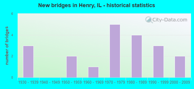
- New bridges - historical statistics
- 31930-1939
- 21950-1959
- 11960-1969
- 51970-1979
- 41980-1989
- 31990-1999
- 22000-2009

- Reconstructed bridges - Historical Statistics
- 11970-1979
- 21980-1989
- 01990-1999
- 02000-2009
- 12010-2019


- Bridge Condition - Deck
- 18.8%Very good
- 18.8%Good
- 43.8%Satisfactory
- 12.5%Fair
- 6.3%Serious

- Bridge Condition - Superstructure
- 25.0%Very good
- 18.8%Good
- 31.3%Satisfactory
- 12.5%Fair
- 12.5%Serious

- Bridge Condition - Substructure
- 18.8%Very good
- 43.8%Good
- 12.5%Satisfactory
- 18.8%Fair
- 6.3%Poor

- Bridge Condition - Channel
- 5.3%Very good
- 42.1%Good
- 21.1%Satisfactory
- 21.1%Fair
- 10.5%Poor

- Bridge Condition - Culverts
- 33.3%Satisfactory
- 66.7%Fair
Find on map >> Show street view
Structure Number: 620036, Location: 1.22 MI E OF ILL 29 (Lat: 41.109892, Lng: -89.353272), Route carried "on" structure: State highway 18, Year Built: 1934, Year Reconstructed: 1988, Status: Temporarily open, Structure Length: 52.40m (171.92ft), Average Daily Traffic: 2,200 (year 2021), Truck Traffic: 8%, Average Future Daily Traffic: 3,064 (year 2032), Design Load: HS 20, Features Intersected: ILL RIVER, CROMWELL
Minimum Vertical Clearance: 4.62m (15.16ft), Kilometerpoint: 1.754, Lanes on structure: 2, Lanes under structure: 2, Base Highway Network: Yes, Owner: State Highway Agency, Approaching Roadway Width: 11.0m (36.1ft), Navigation Control: Yes ( Vertical Clearance: 13.4m (44.0ft), Horizontal Clearance: 103.0m (337.9ft)), Material/Design: Steel, Design/Construction: Truss - Thru, Number Of Spans In Main Unit: 1, Number Of Approach Spans: 13, Length of Maximum Span: 111.0m (364.2ft), Curb-To-Curb Width: 6.9m (22.6ft), Out-to-Out Width: 7.1m (23.3ft)
Condition: Deck: Fair, Superstructure: Serious, Substructure: Poor, Channel: Good, Operating Rating: 32.1 metric tons, Method Used To Determine Operating Rating: Load Factor (LF) rating reported by rating factor (RF) method using MS18 loading, Inventory Rating: 19.1 metric tons, Method Used To Determine Inventory Rating: Load Factor (LF) rating reported by rating factor (RF) method using MS18 loading, Structural Evaluation: High priority of corrective action, Deck Geometry: High priority of replacement, Underclear: High priority of replacement, Waterway Adequacy: Equal to present desirable criteria, Approach Roadway Alignment: Better than present minimum criteria, Length Of Structure Improvement: 52.40m (171.92ft), Designated Inspection Frequency: Every 12 months, Critical Feature Inspection Frequency: Every 12 months, Underwater Inspection Frequency: Every 60 months, Inspection Date: April 2021, Critical Feature Inspection Date: April 2021, Underwater Inspection Date: April 2021, Bridge Improvement Cost: $6,168,000, Roadway Improvement Cost: $617,000, Total Project Cost: $9,252,000, Deck Structure Type: Concrete Cast-file-Place, Wearing Surface/Protective System: Deck Protection: Epoxy Coated Reinforcing
Find on map >> Show street view
Structure Number: 620037, Location: 0.1 W OF ILL 26 (Lat: 41.099092, Lng: -89.342222), Route carried "on" structure: State highway 18, Year Built: 1975, Status: Open, Structure Length: 5.03m (16.50ft), Average Daily Traffic: 2,200 (year 2021), Truck Traffic: 8%, Average Future Daily Traffic: 3,064 (year 2032), Design Load: HS 20, Features Intersected: SANDY CR
Minimum Vertical Clearance: 30+ m (98+ ft), Kilometerpoint: 3.283, Lanes on structure: 2, Base Highway Network: Yes, Owner: State Highway Agency, Approaching Roadway Width: 9.1m (29.9ft), Skew: 1 degrees, Material/Design: Steel continuous, Design/Construction: Stringer/Multi-beam, Number Of Spans In Main Unit: 4, Length of Maximum Span: 13.4m (44.0ft), Curb-To-Curb Width: 9.3m (30.5ft), Out-to-Out Width: 10.3m (33.8ft)
Condition: Deck: Satisfactory, Superstructure: Fair, Substructure: Satisfactory, Channel: Fair, Operating Rating: 56.7 metric tons, Method Used To Determine Operating Rating: Load Factor (LF) rating reported by rating factor (RF) method using MS18 loading, Inventory Rating: 34.0 metric tons, Method Used To Determine Inventory Rating: Load Factor (LF) rating reported by rating factor (RF) method using MS18 loading, Structural Evaluation: Somewhat better than minimum adequacy, Deck Geometry: Meets minimum limits, Waterway Adequacy: High priority of corrective action, Approach Roadway Alignment: Equal to present minimum criteria, Length Of Structure Improvement: 5.03m (16.50ft), Designated Inspection Frequency: Every 24 months, Inspection Date: March 2020, Bridge Improvement Cost: $112,000, Roadway Improvement Cost: $11,000, Total Project Cost: $134,000, Deck Structure Type: Concrete Cast-file-Place, Wearing Surface/Protective System: Wearing Surface: Other
Find on map >> Show street view
Structure Number: 620058, Location: .03 MI S OF IL 18 (Lat: 41.098689, Lng: -89.339906), Route carried "on" structure: State highway 26, Year Built: 1993, Status: Open, Structure Length: 5.49m (18.01ft), Average Daily Traffic: 3,400 (year 2021), Truck Traffic: 12%, Average Future Daily Traffic: 2,896 (year 2032), Design Load: HS 20, Features Intersected: SANDY CREEK
Minimum Vertical Clearance: 30+ m (98+ ft), Kilometerpoint: 47.667, Lanes on structure: 2, Owner: State Highway Agency, Approaching Roadway Width: 9.8m (32.2ft), Material/Design: Steel continuous, Design/Construction: Stringer/Multi-beam, Number Of Spans In Main Unit: 3, Length of Maximum Span: 21.3m (69.9ft), Curb-To-Curb Width: 9.8m (32.2ft), Out-to-Out Width: 10.7m (35.1ft)
Condition: Deck: Fair, Superstructure: Fair, Substructure: Good, Channel: Fair, Operating Rating: 61.2 metric tons, Method Used To Determine Operating Rating: Load Factor (LF) rating reported by rating factor (RF) method using MS18 loading, Inventory Rating: 36.9 metric tons, Method Used To Determine Inventory Rating: Load Factor (LF) rating reported by rating factor (RF) method using MS18 loading, Structural Evaluation: Somewhat better than minimum adequacy, Deck Geometry: Meets minimum limits, Waterway Adequacy: Equal to present minimum criteria, Approach Roadway Alignment: Equal to present minimum criteria, Designated Inspection Frequency: Every 24 months, Inspection Date: March 2021, Deck Structure Type: Concrete Cast-file-Place, Wearing Surface/Protective System: Deck Protection: Epoxy Coated Reinforcing
Find on map >> Show street view
Structure Number: 622004, Location: 0.3 E. OF RT 26 (Lat: 41.100658, Lng: -89.336292), Route carried "on" structure: State highway 18, Year Built: 1975, Status: Open, Structure Length: 0.76m (2.49ft), Average Daily Traffic: 3,250 (year 2021), Truck Traffic: 14%, Average Future Daily Traffic: 2,451 (year 2032), Design Load: HS 20, Features Intersected: SANDY CR OVERFLOW
Minimum Vertical Clearance: 30+ m (98+ ft), Kilometerpoint: 3.878, Lanes on structure: 2, Base Highway Network: Yes, Owner: State Highway Agency, Approaching Roadway Width: 13.4m (44.0ft), Skew: 1 degrees, Material/Design: Concrete continuous, Design/Construction: Culvert, Number Of Spans In Main Unit: 2, Length of Maximum Span: 4.0m (13.1ft)
Condition: Channel: Fair, Culverts: Fair, Operating Rating: 89.1 metric tons, Method Used To Determine Operating Rating: Allowable Stress (AS) rating reported by rating factor (RF) method using MS18 loading, Inventory Rating: 36.9 metric tons, Method Used To Determine Inventory Rating: Allowable Stress (AS) rating reported by rating factor (RF) method using MS18 loading, Structural Evaluation: Somewhat better than minimum adequacy, Waterway Adequacy: Equal to present minimum criteria, Approach Roadway Alignment: Equal to present desirable criteria, Designated Inspection Frequency: Every 24 months, Inspection Date: March 2021
Find on map >> Show street view
Structure Number: 623092, Location: T13N-R10E-4PM SEC 18 (Lat: 41.111472, Lng: -89.405964), Route carried "on" structure: County highway , Year Built: 1989, Status: Open, Structure Length: 4.72m (15.49ft), Average Daily Traffic: 350 (year 2019), Truck Traffic: 11%, Average Future Daily Traffic: 668 (year 2032), Design Load: HS 20, Features Intersected: CROW CREEK, Facility Carried by Structure: FAS 372 CH 6
Minimum Vertical Clearance: 30+ m (98+ ft), Kilometerpoint: 19.923, Lanes on structure: 2, Owner: County Highway Agency, Approaching Roadway Width: 10.4m (34.1ft), Skew: 4 degrees, Material/Design: Prestressed concrete, Design/Construction: Box Beam or Girders - Multiple, Number Of Spans In Main Unit: 3, Length of Maximum Span: 19.8m (65.0ft), Curb-To-Curb Width: 9.1m (29.9ft), Out-to-Out Width: 9.1m (29.9ft)
Condition: Deck: Very good, Superstructure: Very good, Substructure: Very good, Channel: Good, Operating Rating: 44.4 metric tons, Method Used To Determine Operating Rating: Assigned rating based on Load Factor Design (LFD) reported by rating factor (RF) using MS18 loading, Inventory Rating: 32.4 metric tons, Method Used To Determine Inventory Rating: Assigned rating based on Load Factor Design (LFD) reported by rating factor (RF) using MS18 loading, Structural Evaluation: Equal to present desirable criteria, Deck Geometry: Equal to present minimum criteria, Waterway Adequacy: Equal to present desirable criteria, Approach Roadway Alignment: Equal to present desirable criteria, Designated Inspection Frequency: Every 48 months, Inspection Date: August 2019, Deck Structure Type: Concrete Precast Panels, Wearing Surface/Protective System: Wearing Surface: Bituminous, Membrane: Built-up
Find on map >> Show street view
Structure Number: 62412, Location: T13N-R9E-4PM SEC 12 (Lat: 41.125800, Lng: -89.411825), Route carried "on" structure: County highway , Year Built: 1971, Status: Open, Structure Length: 2.99m (9.81ft), Average Daily Traffic: 100 (year 2019), Truck Traffic: 41%, Average Future Daily Traffic: 111 (year 2032), Design Load: HS 15, Features Intersected: BRANCH CROW CREEK, Facility Carried by Structure: TR 13 (TH-C55)
Minimum Vertical Clearance: 30+ m (98+ ft), Kilometerpoint: 14.484, Lanes on structure: 2, Owner: Town or Township Highway Agency, Approaching Roadway Width: 6.7m (22.0ft), Skew: 1 degrees, Material/Design: Concrete, Design/Construction: Channel Beam, Number Of Spans In Main Unit: 3, Length of Maximum Span: 11.0m (36.1ft), Curb-To-Curb Width: 6.2m (20.3ft), Out-to-Out Width: 6.9m (22.6ft)
Condition: Deck: Satisfactory, Superstructure: Satisfactory, Substructure: Satisfactory, Channel: Satisfactory, Operating Rating: 51.2 metric tons, Method Used To Determine Operating Rating: Load Factor (LF) rating reported by rating factor (RF) method using MS18 loading, Inventory Rating: 30.8 metric tons, Method Used To Determine Inventory Rating: Load Factor (LF) rating reported by rating factor (RF) method using MS18 loading, Structural Evaluation: Equal to present minimum criteria, Deck Geometry: Somewhat better than minimum adequacy, Waterway Adequacy: Better than present minimum criteria, Approach Roadway Alignment: Equal to present desirable criteria, Designated Inspection Frequency: Every 24 months, Inspection Date: August 2021, Deck Structure Type: Concrete Precast Panels, Wearing Surface/Protective System: Wearing Surface: Other
Find on map >> Show street view
Structure Number: 624157, Location: T13N-R9E-4PM SEC 1 (Lat: 41.133519, Lng: -89.409892), Route carried "on" structure: County highway , Year Built: 1981, Status: Open, Structure Length: 4.69m (15.39ft), Average Daily Traffic: 100 (year 2019), Truck Traffic: 30%, Average Future Daily Traffic: 84 (year 2032), Design Load: HS 20, Features Intersected: CROW CREEK, Facility Carried by Structure: TR 9A (TH-C54)
Minimum Vertical Clearance: 30+ m (98+ ft), Kilometerpoint: 6.180, Lanes on structure: 2, Owner: Town or Township Highway Agency, Approaching Roadway Width: 8.5m (27.9ft), Skew: 4 degrees, Material/Design: Prestressed concrete, Design/Construction: Box Beam or Girders - Multiple, Number Of Spans In Main Unit: 3, Length of Maximum Span: 20.1m (65.9ft), Curb-To-Curb Width: 7.3m (24.0ft), Out-to-Out Width: 7.4m (24.3ft)
Condition: Deck: Good, Superstructure: Good, Substructure: Good, Channel: Satisfactory, Operating Rating: 60.3 metric tons, Method Used To Determine Operating Rating: Load Factor (LF) rating reported by rating factor (RF) method using MS18 loading, Inventory Rating: 36.0 metric tons, Method Used To Determine Inventory Rating: Load Factor (LF) rating reported by rating factor (RF) method using MS18 loading, Structural Evaluation: Better than present minimum criteria, Deck Geometry: Equal to present minimum criteria, Waterway Adequacy: Equal to present desirable criteria, Approach Roadway Alignment: Equal to present desirable criteria, Designated Inspection Frequency: Every 48 months, Inspection Date: August 2019, Deck Structure Type: Concrete Precast Panels, Wearing Surface/Protective System: Wearing Surface: Other
Find on map >> Show street view
Structure Number: 624158, Location: T13N-R9E-4PM SEC 1 (Lat: 41.134828, Lng: -89.423867), Route carried "on" structure: County highway , Year Built: 1980, Status: Open, Structure Length: 1.92m (6.30ft), Average Daily Traffic: 100 (year 2019), Truck Traffic: 30%, Average Future Daily Traffic: 84 (year 2032), Design Load: HS 20, Features Intersected: BRANCH CROW CREEK, Facility Carried by Structure: TR 9A (TH-C54)
Minimum Vertical Clearance: 30+ m (98+ ft), Kilometerpoint: 4.989, Lanes on structure: 2, Owner: Town or Township Highway Agency, Approaching Roadway Width: 8.5m (27.9ft), Skew: 2 degrees, Material/Design: Prestressed concrete, Design/Construction: Box Beam or Girders - Multiple, Number Of Spans In Main Unit: 1, Length of Maximum Span: 19.2m (63.0ft), Curb-To-Curb Width: 7.3m (24.0ft), Out-to-Out Width: 7.4m (24.3ft)
Condition: Deck: Good, Superstructure: Good, Substructure: Good, Channel: Good, Operating Rating: 44.4 metric tons, Method Used To Determine Operating Rating: Assigned rating based on Load Factor Design (LFD) reported by rating factor (RF) using MS18 loading, Inventory Rating: 32.4 metric tons, Method Used To Determine Inventory Rating: Assigned rating based on Load Factor Design (LFD) reported by rating factor (RF) using MS18 loading, Structural Evaluation: Better than present minimum criteria, Deck Geometry: Equal to present minimum criteria, Waterway Adequacy: Better than present minimum criteria, Approach Roadway Alignment: Equal to present desirable criteria, Designated Inspection Frequency: Every 48 months, Inspection Date: August 2019, Deck Structure Type: Concrete Precast Panels, Wearing Surface/Protective System: Wearing Surface: Other
Find on map >> Show street view
Structure Number: 624169, Location: T13N-R9E-4PM SEC 25 (Lat: 41.089872, Lng: -89.424467), Route carried "on" structure: County highway , Year Built: 1991, Status: Open, Structure Length: 4.86m (15.94ft), Average Daily Traffic: 50 (year 2019), Truck Traffic: 62%, Average Future Daily Traffic: 139 (year 2032), Design Load: HS 20, Features Intersected: CROW CREEK, Facility Carried by Structure: TR 31 (TH-C59)
Minimum Vertical Clearance: 30+ m (98+ ft), Kilometerpoint: 18.169, Lanes on structure: 2, Owner: Town or Township Highway Agency, Approaching Roadway Width: 6.7m (22.0ft), Material/Design: Prestressed concrete, Design/Construction: Box Beam or Girders - Multiple, Number Of Spans In Main Unit: 3, Length of Maximum Span: 20.8m (68.2ft), Curb-To-Curb Width: 7.3m (24.0ft), Out-to-Out Width: 7.3m (24.0ft)
Condition: Deck: Very good, Superstructure: Very good, Substructure: Very good, Channel: Very good, Operating Rating: 44.4 metric tons, Method Used To Determine Operating Rating: Assigned rating based on Load Factor Design (LFD) reported by rating factor (RF) using MS18 loading, Inventory Rating: 32.4 metric tons, Method Used To Determine Inventory Rating: Assigned rating based on Load Factor Design (LFD) reported by rating factor (RF) using MS18 loading, Structural Evaluation: Equal to present desirable criteria, Deck Geometry: Equal to present minimum criteria, Waterway Adequacy: Equal to present desirable criteria, Approach Roadway Alignment: Equal to present desirable criteria, Designated Inspection Frequency: Every 48 months, Inspection Date: August 2019, Deck Structure Type: Concrete Precast Panels, Wearing Surface/Protective System: Wearing Surface: Other
Find on map >> Show street view
Structure Number: 624328, Location: T30N-R2W-3PM SEC 2 (Lat: 41.090211, Lng: -89.302669), Route carried "on" structure: County highway , Year Built: 1977, Status: Open, Structure Length: 4.75m (15.58ft), Average Daily Traffic: 50 (year 2019), Truck Traffic: 30%, Average Future Daily Traffic: 84 (year 2032), Design Load: HS 20, Features Intersected: SANDY CREEK, Facility Carried by Structure: TR 86 (TH-S34)
Minimum Vertical Clearance: 30+ m (98+ ft), Kilometerpoint: 1.625, Lanes on structure: 2, Owner: Town or Township Highway Agency, Approaching Roadway Width: 6.7m (22.0ft), Material/Design: Prestressed concrete, Design/Construction: Box Beam or Girders - Multiple, Number Of Spans In Main Unit: 3, Length of Maximum Span: 18.3m (60.0ft), Curb-To-Curb Width: 6.4m (21.0ft), Out-to-Out Width: 6.4m (21.0ft)
Condition: Deck: Satisfactory, Superstructure: Satisfactory, Substructure: Good, Channel: Fair, Operating Rating: 44.4 metric tons, Method Used To Determine Operating Rating: Assigned rating based on Load Factor Design (LFD) reported by rating factor (RF) using MS18 loading, Inventory Rating: 32.4 metric tons, Method Used To Determine Inventory Rating: Assigned rating based on Load Factor Design (LFD) reported by rating factor (RF) using MS18 loading, Structural Evaluation: Equal to present minimum criteria, Deck Geometry: Somewhat better than minimum adequacy, Waterway Adequacy: Better than present minimum criteria, Approach Roadway Alignment: Equal to present desirable criteria, Designated Inspection Frequency: Every 24 months, Inspection Date: April 2021, Deck Structure Type: Concrete Precast Panels, Wearing Surface/Protective System: Wearing Surface: Gravel
Find on map >> Show street view
Structure Number: 624333, Location: T30N-R2W-3PM SEC 3 (Lat: 41.088642, Lng: -89.330283), Route carried "on" structure: County highway , Year Built: 1986, Status: Open, Structure Length: 1.89m (6.20ft), Average Daily Traffic: 75 (year 2019), Truck Traffic: 12%, Average Future Daily Traffic: 84 (year 2032), Design Load: HS 20, Features Intersected: CREEK, Facility Carried by Structure: TR 33 (TH-C60)
Minimum Vertical Clearance: 30+ m (98+ ft), Kilometerpoint: 0.129, Lanes on structure: 2, Owner: Town or Township Highway Agency, Approaching Roadway Width: 7.3m (24.0ft), Material/Design: Prestressed concrete, Design/Construction: Box Beam or Girders - Multiple, Number Of Spans In Main Unit: 1, Length of Maximum Span: 18.3m (60.0ft), Curb-To-Curb Width: 7.3m (24.0ft), Out-to-Out Width: 7.3m (24.0ft)
Condition: Deck: Satisfactory, Superstructure: Satisfactory, Substructure: Very good, Channel: Good, Operating Rating: 44.4 metric tons, Method Used To Determine Operating Rating: Assigned rating based on Load Factor Design (LFD) reported by rating factor (RF) using MS18 loading, Inventory Rating: 32.4 metric tons, Method Used To Determine Inventory Rating: Assigned rating based on Load Factor Design (LFD) reported by rating factor (RF) using MS18 loading, Structural Evaluation: Equal to present minimum criteria, Deck Geometry: Equal to present minimum criteria, Waterway Adequacy: Equal to present desirable criteria, Approach Roadway Alignment: Equal to present desirable criteria, Designated Inspection Frequency: Every 24 months, Inspection Date: April 2021, Deck Structure Type: Concrete Precast Panels, Wearing Surface/Protective System: Wearing Surface: Bituminous
Find on map >> Show street view
Structure Number: 780005, Location: 3.17 MI N OF ILL 18 (Lat: 41.156192, Lng: -89.376589), Route carried "on" structure: State highway 29, Year Built: 1960, Status: Open, Structure Length: 0.91m (2.99ft), Average Daily Traffic: 2,900 (year 2021), Truck Traffic: 16%, Average Future Daily Traffic: 3,075 (year 2032), Design Load: HS 20, Features Intersected: ILL RIVER TRIB
Minimum Vertical Clearance: 30+ m (98+ ft), Kilometerpoint: 245.692, Lanes on structure: 2, Base Highway Network: Yes, Owner: State Highway Agency, Approaching Roadway Width: 12.8m (42.0ft), Skew: 2 degrees, Material/Design: Concrete, Design/Construction: Slab, Number Of Spans In Main Unit: 1, Length of Maximum Span: 8.8m (28.9ft), Curb-To-Curb Width: 12.5m (41.0ft), Out-to-Out Width: 13.5m (44.3ft)
Condition: Deck: Satisfactory, Superstructure: Satisfactory, Substructure: Fair, Channel: Good, Operating Rating: 49.2 metric tons, Method Used To Determine Operating Rating: Load Factor (LF) rating reported by rating factor (RF) method using MS18 loading, Inventory Rating: 29.5 metric tons, Method Used To Determine Inventory Rating: Load Factor (LF) rating reported by rating factor (RF) method using MS18 loading, Structural Evaluation: Somewhat better than minimum adequacy, Deck Geometry: Equal to present minimum criteria, Waterway Adequacy: Equal to present desirable criteria, Approach Roadway Alignment: Equal to present desirable criteria, Designated Inspection Frequency: Every 24 months, Inspection Date: March 2020, Deck Structure Type: Concrete Cast-file-Place, Wearing Surface/Protective System: Wearing Surface: Latex Concrete
Find on map >> Show street view
Structure Number: 780013, Location: 0.65 MI E OF ILL 26 (Lat: 41.104386, Lng: -89.319603), Route carried "on" structure: State highway 18, Year Built: 1932, Year Reconstructed: 1979, Status: Open, Structure Length: 2.07m (6.79ft), Average Daily Traffic: 2,500 (year 2021), Truck Traffic: 13%, Average Future Daily Traffic: 1,281 (year 2032), Design Load: HS 20, Features Intersected: DRAINAGE DITCH
Minimum Vertical Clearance: 30+ m (98+ ft), Kilometerpoint: 5.552, Lanes on structure: 2, Base Highway Network: Yes, Owner: State Highway Agency, Approaching Roadway Width: 7.3m (24.0ft), Skew: 4 degrees, Material/Design: Concrete continuous, Design/Construction: Slab, Number Of Spans In Main Unit: 3, Length of Maximum Span: 6.7m (22.0ft), Curb-To-Curb Width: 9.3m (30.5ft), Out-to-Out Width: 9.9m (32.5ft)
Condition: Deck: Serious, Superstructure: Serious, Substructure: Fair, Channel: Poor, Operating Rating: 62.5 metric tons, Method Used To Determine Operating Rating: Load Factor (LF) rating reported by rating factor (RF) method using MS18 loading, Inventory Rating: 37.3 metric tons, Method Used To Determine Inventory Rating: Load Factor (LF) rating reported by rating factor (RF) method using MS18 loading, Structural Evaluation: High priority of corrective action, Deck Geometry: Meets minimum limits, Waterway Adequacy: Equal to present minimum criteria, Approach Roadway Alignment: Equal to present minimum criteria, Designated Inspection Frequency: Every 12 months, Inspection Date: January 2021, Deck Structure Type: Concrete Cast-file-Place, Wearing Surface/Protective System: Wearing Surface: Bituminous, Membrane: Built-up
Find on map >> Show street view
Structure Number: 780033, Location: 1.45 MI E OF ILL 26 (Lat: 41.107514, Lng: -89.305906), Route carried "on" structure: State highway 18, Year Built: 1979, Year Reconstructed: 2017, Status: Open, Structure Length: 0.85m (2.79ft), Average Daily Traffic: 2,500 (year 2021), Truck Traffic: 13%, Average Future Daily Traffic: 1,281 (year 2032), Design Load: HS 25 or greater, Features Intersected: DRAINAGE DITCH
Minimum Vertical Clearance: 30+ m (98+ ft), Kilometerpoint: 6.840, Lanes on structure: 2, Base Highway Network: Yes, Owner: State Highway Agency, Approaching Roadway Width: 7.3m (24.0ft), Skew: 1 degrees, Material/Design: Concrete, Design/Construction: Slab, Number Of Spans In Main Unit: 1, Length of Maximum Span: 8.2m (26.9ft), Curb-To-Curb Width: 9.9m (32.5ft), Out-to-Out Width: 10.1m (33.1ft)
Condition: Deck: Very good, Superstructure: Very good, Substructure: Good, Channel: Good, Operating Rating: 87.8 metric tons, Method Used To Determine Operating Rating: Load and Resistance Factor Rating (LRFR) rating reported by rating factor(RF) method using HL-93 loadings, Inventory Rating: 67.7 metric tons, Method Used To Determine Inventory Rating: Load and Resistance Factor Rating (LRFR) rating reported by rating factor(RF) method using HL-93 loadings, Structural Evaluation: Better than present minimum criteria, Deck Geometry: Meets minimum limits, Waterway Adequacy: Superior to present desirable criteria, Approach Roadway Alignment: Equal to present minimum criteria, Designated Inspection Frequency: Every 48 months, Inspection Date: November 2019, Deck Structure Type: Concrete Cast-file-Place, Wearing Surface/Protective System: Deck Protection: Epoxy Coated Reinforcing
Find on map >> Show street view
Structure Number: 780034, Location: 0.5 mi n of IL 18 (Lat: 41.105344, Lng: -89.331725), Route carried "on" structure: State highway 26, Year Built: 1993, Status: Open, Structure Length: 1.37m (4.49ft), Average Daily Traffic: 900 (year 2021), Truck Traffic: 12%, Average Future Daily Traffic: 794 (year 2032), Design Load: HS 20, Features Intersected: STREAM
Minimum Vertical Clearance: 30+ m (98+ ft), Kilometerpoint: 48.778, Lanes on structure: 2, Owner: State Highway Agency, Approaching Roadway Width: 9.8m (32.2ft), Material/Design: Concrete, Design/Construction: Slab, Number Of Spans In Main Unit: 1, Length of Maximum Span: 12.8m (42.0ft), Curb-To-Curb Width: 9.8m (32.2ft), Out-to-Out Width: 10.7m (35.1ft)
Condition: Deck: Satisfactory, Superstructure: Satisfactory, Substructure: Good, Channel: Good, Operating Rating: 65.1 metric tons, Method Used To Determine Operating Rating: Load Factor (LF) rating reported by rating factor (RF) method using MS18 loading, Inventory Rating: 39.2 metric tons, Method Used To Determine Inventory Rating: Load Factor (LF) rating reported by rating factor (RF) method using MS18 loading, Structural Evaluation: Equal to present minimum criteria, Deck Geometry: Equal to present minimum criteria, Waterway Adequacy: Equal to present desirable criteria, Approach Roadway Alignment: Equal to present minimum criteria, Designated Inspection Frequency: Every 24 months, Inspection Date: January 2021, Deck Structure Type: Concrete Cast-file-Place, Wearing Surface/Protective System: Deck Protection: Epoxy Coated Reinforcing
Find on map >> Show street view
Structure Number: 780036, Location: 7.95 MI S OF IL 71 (Lat: 41.143908, Lng: -89.304525), Route carried "on" structure: State highway 26, Year Built: 2001, Status: Open, Structure Length: 4.25m (13.94ft), Average Daily Traffic: 900 (year 2021), Truck Traffic: 12%, Average Future Daily Traffic: 794 (year 2032), Design Load: HS 20, Features Intersected: CLEAR CREEK
Minimum Vertical Clearance: 30+ m (98+ ft), Kilometerpoint: 53.686, Lanes on structure: 2, Owner: State Highway Agency, Approaching Roadway Width: 9.6m (31.5ft), Material/Design: Steel continuous, Design/Construction: Stringer/Multi-beam, Number Of Spans In Main Unit: 2, Length of Maximum Span: 20.9m (68.6ft), Curb-To-Curb Width: 9.6m (31.5ft), Out-to-Out Width: 10.6m (34.8ft)
Condition: Deck: Satisfactory, Superstructure: Very good, Substructure: Good, Channel: Satisfactory, Operating Rating: 81.3 metric tons, Method Used To Determine Operating Rating: Load Factor (LF) rating reported by rating factor (RF) method using MS18 loading, Inventory Rating: 48.9 metric tons, Method Used To Determine Inventory Rating: Load Factor (LF) rating reported by rating factor (RF) method using MS18 loading, Structural Evaluation: Better than present minimum criteria, Deck Geometry: Equal to present minimum criteria, Waterway Adequacy: Equal to present minimum criteria, Approach Roadway Alignment: Equal to present desirable criteria, Designated Inspection Frequency: Every 48 months, Inspection Date: January 2021, Deck Structure Type: Concrete Cast-file-Place, Wearing Surface/Protective System: Deck Protection: Epoxy Coated Reinforcing
Find on map >> Show street view
Structure Number: 782003, Location: 6.88 MI S OF ILL 71 (Lat: 41.159119, Lng: -89.304317), Route carried "on" structure: State highway 26, Year Built: 1956, Status: Open, Structure Length: 0.91m (2.99ft), Average Daily Traffic: 900 (year 2021), Truck Traffic: 12%, Average Future Daily Traffic: 794 (year 2032), Design Load: HS 15, Features Intersected: STREAM
Minimum Vertical Clearance: 30+ m (98+ ft), Kilometerpoint: 55.392, Lanes on structure: 2, Owner: State Highway Agency, Approaching Roadway Width: 6.7m (22.0ft), Skew: 3 degrees, Material/Design: Concrete continuous, Design/Construction: Culvert, Number Of Spans In Main Unit: 2, Length of Maximum Span: 4.2m (13.8ft)
Condition: Channel: Poor, Culverts: Fair, Operating Rating: 42.4 metric tons, Method Used To Determine Operating Rating: Load Factor (LF) rating reported by rating factor (RF) method using MS18 loading, Inventory Rating: 25.3 metric tons, Method Used To Determine Inventory Rating: Load Factor (LF) rating reported by rating factor (RF) method using MS18 loading, Structural Evaluation: Somewhat better than minimum adequacy, Waterway Adequacy: Somewhat better than minimum adequacy, Approach Roadway Alignment: Equal to present desirable criteria, Designated Inspection Frequency: Every 24 months, Inspection Date: August 2020
Find on map >> Show street view
Structure Number: 782006, Location: 8.20 MI S OF IL 71 (Lat: 41.140369, Lng: -89.305983), Route carried "on" structure: State highway 26, Year Built: 2001, Status: Open, Structure Length: 1.20m (3.94ft), Average Daily Traffic: 900 (year 2021), Truck Traffic: 12%, Average Future Daily Traffic: 794 (year 2032), Design Load: HS 20, Features Intersected: CLEAR CREEK (OVRFLW)
Minimum Vertical Clearance: 30+ m (98+ ft), Kilometerpoint: 53.268, Lanes on structure: 2, Owner: State Highway Agency, Approaching Roadway Width: 11.4m (37.4ft), Material/Design: Concrete continuous, Design/Construction: Culvert, Number Of Spans In Main Unit: 3, Length of Maximum Span: 3.7m (12.1ft), Curb-To-Curb Width: 11.4m (37.4ft), Out-to-Out Width: 14.2m (46.6ft)
Condition: Channel: Good, Culverts: Satisfactory, Operating Rating: 62.9 metric tons, Method Used To Determine Operating Rating: Load Factor (LF) rating reported by rating factor (RF) method using MS18 loading, Inventory Rating: 37.6 metric tons, Method Used To Determine Inventory Rating: Load Factor (LF) rating reported by rating factor (RF) method using MS18 loading, Structural Evaluation: Equal to present minimum criteria, Deck Geometry: Better than present minimum criteria, Waterway Adequacy: Equal to present desirable criteria, Approach Roadway Alignment: Equal to present desirable criteria, Designated Inspection Frequency: Every 24 months, Inspection Date: January 2021
Find on map >> Show street view
Structure Number: 783008, Location: 425N, 395E (Lat: 41.165928, Lng: -89.390367), Route carried "on" structure: County highway , Year Built: 1955, Year Reconstructed: 1980, Status: Open, Structure Length: 0.73m (2.40ft), Average Daily Traffic: 50 (year 2018), Average Future Daily Traffic: 51 (year 2032), Design Load: HS 20, Features Intersected: SENACHWINE LAKE TRIB, Facility Carried by Structure: TR 20
Minimum Vertical Clearance: 30+ m (98+ ft), Kilometerpoint: 2.253, Lanes on structure: 2, Owner: Town or Township Highway Agency, Approaching Roadway Width: 7.3m (24.0ft), Material/Design: Concrete, Design/Construction: Channel Beam, Number Of Spans In Main Unit: 1, Length of Maximum Span: 7.1m (23.3ft), Curb-To-Curb Width: 6.9m (22.6ft), Out-to-Out Width: 6.9m (22.6ft)
Condition: Deck: Good, Superstructure: Good, Substructure: Fair, Channel: Satisfactory, Operating Rating: 66.1 metric tons, Method Used To Determine Operating Rating: Load Factor (LF) rating reported by rating factor (RF) method using MS18 loading, Inventory Rating: 39.5 metric tons, Method Used To Determine Inventory Rating: Load Factor (LF) rating reported by rating factor (RF) method using MS18 loading, Structural Evaluation: Somewhat better than minimum adequacy, Deck Geometry: Somewhat better than minimum adequacy, Waterway Adequacy: Equal to present minimum criteria, Approach Roadway Alignment: Equal to present desirable criteria, Designated Inspection Frequency: Every 24 months, Inspection Date: March 2020, Deck Structure Type: Concrete Precast Panels
Find on map >> Show street view
Structure Number: 620036, Location: 1.22 MI E OF ILL 29 (Lat: 41.109625, Lng: -89.353089), Route carried "under" structure: City street , Year Built: 1934, Structure Length: 0. m, Average Daily Traffic: 125 (year 2019), Truck Traffic: 11%, Features Intersected: ILL RIVER, CROMWELL, Facility Carried by Structure: ILL 18
Minimum Vertical Clearance: 4.85m (15.91ft), Kilometerpoint: 0.257, Lanes on structure: 2, Lanes under structure: 2, Material/Design: Steel, Design/Construction: Truss - Thru, Length of Maximum Span: 111.0m (364.2ft)