Bridge Statistics for Hendersonville, Pennsylvania (PA)
Condition, Traffic, Stress, Structural Evaluation, Project Costs
- National Bridge Inventory (NBI) Statistics
- 16Number of bridges
- 154ft / 46.9mTotal length
- 261,820Total average daily traffic
- 32,952Total average daily truck traffic
- National Bridge Inventory (NBI) Registered Bridges for Hendersonville
- No street view available for this location
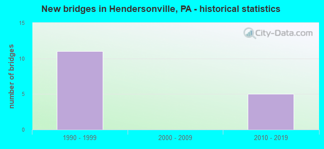
- New bridges - historical statistics
- 111990-1999
- 52010-2019


- Bridge Condition - Deck
- 33.3%Very good
- 66.7%Satisfactory

- Bridge Condition - Superstructure
- 16.7%Excellent
- 16.7%Very good
- 50.0%Good
- 16.7%Satisfactory

- Bridge Condition - Substructure
- 16.7%Excellent
- 16.7%Very good
- 33.3%Good
- 16.7%Satisfactory
- 16.7%Fair

- Bridge Condition - Channel
- 50.0%Very good
- 50.0%Satisfactory

- Bridge Condition - Culverts
- 50.0%Very good
- 50.0%Fair
Find on map >> Show street view
Structure Number: 34583, Location: CECIL TOWNSHIP (Lat: 40.297847, Lng: -80.167875), Route carried "on" structure: Interstate 79, Year Built: 1994, Status: Open, Structure Length: 3.29m (10.79ft), Average Daily Traffic: 36,039 (year 2022), Truck Traffic: 14%, Average Future Daily Traffic: 11,486 (year 2032), Design Load: HS 25 or greater, Features Intersected: SR 1032
Minimum Vertical Clearance: 30+ m (98+ ft), Kilometerpoint: 34.672, Lanes on structure: 3, Lanes under structure: 4, Base Highway Network: Yes, Owner: State Highway Agency, Approaching Roadway Width: 12.2m (40.0ft), Skew: 10 degrees, Material/Design: Prestressed concrete, Design/Construction: Box Beam or Girders - Single/Spread, Number Of Spans In Main Unit: 1, Length of Maximum Span: 32.3m (106.0ft), Curb or Sidewalk Widths: Left: 0.2m (0.7ft), Right: 0.2m (0.7ft), Curb-To-Curb Width: 21.4m (70.2ft), Out-to-Out Width: 23.5m (77.1ft)
Condition: Deck: Satisfactory, Superstructure: Good, Substructure: Satisfactory, Operating Rating: 89.8 metric tons, Method Used To Determine Operating Rating: Load Factor (LF), Inventory Rating: 48.1 metric tons, Method Used To Determine Inventory Rating: Load Factor (LF), Structural Evaluation: Equal to present minimum criteria, Deck Geometry: Superior to present desirable criteria, Underclear: Better than present minimum criteria, Approach Roadway Alignment: Equal to present desirable criteria, Length Of Structure Improvement: 4.10m (13.45ft), Designated Inspection Frequency: Every 24 months, Inspection Date: September 2021, Deck Structure Type: Concrete Cast-file-Place, Wearing Surface/Protective System: Wearing Surface: Monolithic Concrete, Deck Protection: Epoxy Coated Reinforcing
Find on map >> Show street view
Structure Number: 34584, Location: CECIL TOWNSHIP (Lat: 40.298019, Lng: -80.168153), Route carried "on" structure: Interstate 79, Year Built: 1994, Status: Open, Structure Length: 3.29m (10.79ft), Average Daily Traffic: 36,907 (year 2022), Truck Traffic: 13%, Average Future Daily Traffic: 11,015 (year 2032), Design Load: HS 25 or greater, Features Intersected: SR 1032
Minimum Vertical Clearance: 30+ m (98+ ft), Kilometerpoint: 35.436, Lanes on structure: 2, Lanes under structure: 8, Base Highway Network: Yes, Owner: State Highway Agency, Approaching Roadway Width: 12.2m (40.0ft), Skew: 10 degrees, Material/Design: Prestressed concrete, Design/Construction: Box Beam or Girders - Single/Spread, Number Of Spans In Main Unit: 1, Length of Maximum Span: 32.3m (106.0ft), Curb or Sidewalk Widths: Left: 0.2m (0.7ft), Right: 0.2m (0.7ft), Curb-To-Curb Width: 12.2m (40.0ft), Out-to-Out Width: 13.3m (43.6ft)
Condition: Deck: Satisfactory, Superstructure: Good, Substructure: Fair, Operating Rating: 87.1 metric tons, Method Used To Determine Operating Rating: Load Factor (LF), Inventory Rating: 51.7 metric tons, Method Used To Determine Inventory Rating: Load Factor (LF), Structural Evaluation: Somewhat better than minimum adequacy, Deck Geometry: Better than present minimum criteria, Underclear: Superior to present desirable criteria, Approach Roadway Alignment: Equal to present desirable criteria, Length Of Structure Improvement: 4.10m (13.45ft), Designated Inspection Frequency: Every 24 months, Inspection Date: September 2021, Deck Structure Type: Concrete Cast-file-Place, Wearing Surface/Protective System: Wearing Surface: Monolithic Concrete, Deck Protection: Epoxy Coated Reinforcing
Find on map >> Show street view
Structure Number: 40336, Location: CECIL TWP (Lat: 40.304972, Lng: -80.161144), Route carried "on" structure: Interstate 79, Year Built: 1998, Status: Open, Structure Length: 12.95m (42.49ft), Average Daily Traffic: 36,039 (year 2022), Truck Traffic: 14%, Average Future Daily Traffic: 11,486 (year 2032), Design Load: HS 25 or greater, Features Intersected: SR 1010, BIKE TRAIL
Minimum Vertical Clearance: 30+ m (98+ ft), Kilometerpoint: 35.362, Lanes on structure: 2, Lanes under structure: 2, Base Highway Network: Yes, Owner: State Highway Agency, Approaching Roadway Width: 12.8m (42.0ft), Skew: 10 degrees, Material/Design: Steel continuous, Design/Construction: Stringer/Multi-beam, Number Of Spans In Main Unit: 1, Number Of Approach Spans: 2, Length of Maximum Span: 43.0m (141.1ft), Curb or Sidewalk Widths: Left: 0.2m (0.7ft), Right: 0.2m (0.7ft), Curb-To-Curb Width: 12.8m (42.0ft), Out-to-Out Width: 13.9m (45.6ft)
Condition: Deck: Satisfactory, Superstructure: Satisfactory, Substructure: Good, Channel: Very good, Operating Rating: 61.7 metric tons, Method Used To Determine Operating Rating: Load Factor (LF), Inventory Rating: 37.2 metric tons, Method Used To Determine Inventory Rating: Load Factor (LF), Structural Evaluation: Equal to present minimum criteria, Deck Geometry: Equal to present desirable criteria, Underclear: Superior to present desirable criteria, Waterway Adequacy: Superior to present desirable criteria, Approach Roadway Alignment: Equal to present desirable criteria, Length Of Structure Improvement: 13.90m (45.60ft), Designated Inspection Frequency: Every 24 months, Inspection Date: September 2021, Deck Structure Type: Concrete Cast-file-Place, Wearing Surface/Protective System: Wearing Surface: Monolithic Concrete, Deck Protection: Epoxy Coated Reinforcing
Find on map >> Show street view
Structure Number: 40337, Location: CECIL TWP (Lat: 40.305144, Lng: -80.161369), Route carried "on" structure: Interstate 79, Year Built: 1998, Status: Open, Structure Length: 12.95m (42.49ft), Average Daily Traffic: 36,907 (year 2022), Truck Traffic: 13%, Average Future Daily Traffic: 11,015 (year 2032), Design Load: HS 25 or greater, Features Intersected: SR 1010, BIKE TRAIL
Minimum Vertical Clearance: 30+ m (98+ ft), Kilometerpoint: 36.154, Lanes on structure: 2, Lanes under structure: 2, Base Highway Network: Yes, Owner: State Highway Agency, Approaching Roadway Width: 12.8m (42.0ft), Skew: 10 degrees, Material/Design: Steel continuous, Design/Construction: Stringer/Multi-beam, Number Of Spans In Main Unit: 1, Number Of Approach Spans: 2, Length of Maximum Span: 43.0m (141.1ft), Curb or Sidewalk Widths: Left: 0.2m (0.7ft), Right: 0.2m (0.7ft), Curb-To-Curb Width: 12.8m (42.0ft), Out-to-Out Width: 13.9m (45.6ft)
Condition: Deck: Satisfactory, Superstructure: Good, Substructure: Good, Channel: Very good, Operating Rating: 75.3 metric tons, Method Used To Determine Operating Rating: Load Factor (LF), Inventory Rating: 44.5 metric tons, Method Used To Determine Inventory Rating: Load Factor (LF), Structural Evaluation: Better than present minimum criteria, Deck Geometry: Equal to present desirable criteria, Underclear: Superior to present desirable criteria, Waterway Adequacy: Superior to present desirable criteria, Approach Roadway Alignment: Equal to present desirable criteria, Length Of Structure Improvement: 13.90m (45.60ft), Designated Inspection Frequency: Every 24 months, Inspection Date: September 2021, Deck Structure Type: Concrete Cast-file-Place, Wearing Surface/Protective System: Wearing Surface: Monolithic Concrete, Deck Protection: Epoxy Coated Reinforcing
Find on map >> Show street view
Structure Number: 46269, Location: 3.5 mi N of SR 0980 (Lat: 40.299183, Lng: -80.152797), Route carried "on" structure: State highway , Year Built: 2010, Status: Open, Structure Length: 0.73m (2.40ft), Average Daily Traffic: 10,723 (year 2022), Truck Traffic: 6%, Average Future Daily Traffic: 9,248 (year 2032), Design Load: HL 93, Features Intersected: McPherson Creek, Facility Carried by Structure: SR 1009
Minimum Vertical Clearance: 30+ m (98+ ft), Kilometerpoint: 16.818, Lanes on structure: 2, Owner: State Highway Agency, Approaching Roadway Width: 9.1m (29.9ft), Material/Design: Concrete, Design/Construction: Culvert, Number Of Spans In Main Unit: 1, Length of Maximum Span: 6.7m (22.0ft), Curb-To-Curb Width: 9.9m (32.5ft), Out-to-Out Width: 11.2m (36.7ft)
Condition: Channel: Satisfactory, Culverts: Very good, Operating Rating: 65.3 metric tons, Method Used To Determine Operating Rating: Load and Resistance Factor (LRFR), Inventory Rating: 49.9 metric tons, Method Used To Determine Inventory Rating: Load and Resistance Factor (LRFR), Structural Evaluation: Equal to present desirable criteria, Deck Geometry: Meets minimum limits, Waterway Adequacy: Equal to present minimum criteria, Approach Roadway Alignment: Equal to present desirable criteria, Designated Inspection Frequency: Every 24 months, Inspection Date: March 2020
Find on map >> Show street view
Structure Number: 48502, Location: CECILTWP (Lat: 40.290467, Lng: -80.173825), Route carried "on" structure: City street , Year Built: 1995, Status: Open, Structure Length: 0.67m (2.20ft), Average Daily Traffic: 2,000 (year 2015), Truck Traffic: 2%, Average Future Daily Traffic: 2,100 (year 2025), Features Intersected: MORGANZA RUN, Facility Carried by Structure: SOUTHPOINTE BLVD.
Minimum Vertical Clearance: 30+ m (98+ ft), Kilometerpoint: 0.000, Lanes on structure: 4, Owner: Town or Township Highway Agency, Approaching Roadway Width: 15.2m (49.9ft), Skew: 1 degrees, Material/Design: Concrete, Design/Construction: Culvert, Number Of Spans In Main Unit: 1, Length of Maximum Span: 6.7m (22.0ft)
Condition: Channel: Satisfactory, Culverts: Fair, Operating Rating: 32.7 metric tons, Method Used To Determine Operating Rating: Field evaluation and documented engineering judgment, Inventory Rating: 21.8 metric tons, Method Used To Determine Inventory Rating: Field evaluation and documented engineering judgment, Structural Evaluation: Somewhat better than minimum adequacy, Waterway Adequacy: Better than present minimum criteria, Approach Roadway Alignment: Equal to present desirable criteria, Designated Inspection Frequency: Every 24 months, Inspection Date: October 2021
Find on map >> Show street view
Structure Number: 57343, Location: Just east of I-79 (Lat: 40.312222, Lng: -80.152222), Route carried "on" structure: County highway 781, Year Built: 2019, Status: Open, Structure Length: 8.20m (26.90ft), Average Daily Traffic: 192 (year 2017), Truck Traffic: 5%, Average Future Daily Traffic: 284 (year 2038), Design Load: HL 93, Features Intersected: PA-TPK (576)
Minimum Vertical Clearance: 30+ m (98+ ft), Kilometerpoint: 30.368, Lanes on structure: 2, Lanes under structure: 4, Toll: Toll bridge, Owner: State Toll Authority, Approaching Roadway Width: 10.4m (34.1ft), Material/Design: Prestressed concrete continuous, Design/Construction: Stringer/Multi-beam, Number Of Spans In Main Unit: 2, Length of Maximum Span: 41.1m (134.8ft), Curb or Sidewalk Widths: Left: 1.8m (5.9ft), Right: 1.8m (5.9ft), Curb-To-Curb Width: 10.4m (34.1ft), Out-to-Out Width: 12.1m (39.7ft)
Condition: Deck: Very good, Superstructure: Very good, Substructure: Very good, Operating Rating: 80.8 metric tons, Method Used To Determine Operating Rating: Assigned ratings based on Load and Resistance Factor Design (LRFD) reported in metric tons, Inventory Rating: 44.5 metric tons, Method Used To Determine Inventory Rating: Assigned ratings based on Load and Resistance Factor Design (LRFD) reported in metric tons, Structural Evaluation: Equal to present desirable criteria, Deck Geometry: Better than present minimum criteria, Underclear: Superior to present desirable criteria, Approach Roadway Alignment: Equal to present desirable criteria, Designated Inspection Frequency: Every 24 months, Inspection Date: December 2019, Deck Structure Type: Concrete Cast-file-Place, Wearing Surface/Protective System: Wearing Surface: Monolithic Concrete, Deck Protection: Epoxy Coated Reinforcing
Find on map >> Show street view
Structure Number: 68482, Location: CECIL TOWNSHIP (Lat: 40.312639, Lng: -80.153278), Route carried "on" structure: State highway , Year Built: 2019, Status: Open, Structure Length: 4.85m (15.91ft), Average Daily Traffic: 1,901 (year 2021), Truck Traffic: 6%, Average Future Daily Traffic: 2,500 (year 2043), Design Load: HL 93, Features Intersected: SR 0079, Facility Carried by Structure: SR 1034 Morgan Rd
Minimum Vertical Clearance: 30+ m (98+ ft), Kilometerpoint: 0.000, Lanes on structure: 2, Lanes under structure: 7, Owner: State Highway Agency, Approaching Roadway Width: 7.3m (24.0ft), Material/Design: Prestressed concrete, Design/Construction: Stringer/Multi-beam, Number Of Spans In Main Unit: 1, Length of Maximum Span: 48.2m (158.1ft), Curb or Sidewalk Widths: Left: 0.2m (0.7ft), Right: 0.2m (0.7ft), Curb-To-Curb Width: 11.0m (36.1ft), Out-to-Out Width: 12.0m (39.4ft)
Condition: Deck: Very good, Superstructure: Excellent, Substructure: Excellent, Operating Rating: 56.1 metric tons, Method Used To Determine Operating Rating: Assigned ratings based on Load and Resistance Factor Design (LRFD) reported by rating factor (RF) using HL93 loadings, Inventory Rating: 40.2 metric tons, Method Used To Determine Inventory Rating: Assigned ratings based on Load and Resistance Factor Design (LRFD) reported by rating factor (RF) using HL93 loadings, Structural Evaluation: Superior to present desirable criteria, Deck Geometry: Equal to present minimum criteria, Underclear: Equal to present minimum criteria, Approach Roadway Alignment: Equal to present desirable criteria, Designated Inspection Frequency: Every 24 months, Inspection Date: September 2021, Deck Structure Type: Concrete Cast-file-Place, Wearing Surface/Protective System: Wearing Surface: Monolithic Concrete, Deck Protection: Epoxy Coated Reinforcing
Find on map >> Show street view
Structure Number: 34583, Location: CECIL TOWNSHIP (Lat: 40.297847, Lng: -80.167875), Route carried "under" structure: State highway , Year Built: 1994, Structure Length: 0. m, Average Daily Traffic: 4,773 (year 2022), Truck Traffic: 10%, Features Intersected: SR 1032, Facility Carried by Structure: SR 0079
Minimum Vertical Clearance: 5.11m (16.77ft), Kilometerpoint: 0.000, Lanes on structure: 3, Lanes under structure: 4, Material/Design: Prestressed concrete, Design/Construction: Box Beam or Girders - Single/Spread, Length of Maximum Span: 32.3m (106.0ft)
Find on map >> Show street view
Structure Number: 34583, Location: CECIL TOWNSHIP (Lat: 40.297847, Lng: -80.167875), Route carried "under" structure: State highway , Year Built: 1994, Structure Length: 0. m, Average Daily Traffic: 7,363 (year 2022), Truck Traffic: 10%, Features Intersected: SR 1032, Facility Carried by Structure: SR 0079
Minimum Vertical Clearance: 5.11m (16.77ft), Kilometerpoint: 0.000, Lanes on structure: 3, Lanes under structure: 4, Material/Design: Prestressed concrete, Design/Construction: Box Beam or Girders - Single/Spread, Length of Maximum Span: 32.3m (106.0ft)
Find on map >> Show street view
Structure Number: 34584, Location: CECIL TOWNSHIP (Lat: 40.298019, Lng: -80.168153), Route carried "under" structure: State highway , Year Built: 1994, Structure Length: 0. m, Average Daily Traffic: 4,773 (year 2022), Truck Traffic: 10%, Features Intersected: SR 1032, Facility Carried by Structure: SR 0079
Minimum Vertical Clearance: 7.57m (24.84ft), Kilometerpoint: 0.000, Lanes on structure: 2, Lanes under structure: 4, Material/Design: Prestressed concrete, Design/Construction: Box Beam or Girders - Single/Spread, Length of Maximum Span: 32.3m (106.0ft)
Find on map >> Show street view
Structure Number: 34584, Location: CECIL TOWNSHIP (Lat: 40.298019, Lng: -80.168153), Route carried "under" structure: State highway , Year Built: 1994, Structure Length: 0. m, Average Daily Traffic: 7,363 (year 2022), Truck Traffic: 10%, Features Intersected: SR 1032, Facility Carried by Structure: SR 0079
Minimum Vertical Clearance: 7.57m (24.84ft), Kilometerpoint: 0.000, Lanes on structure: 2, Lanes under structure: 4, Material/Design: Prestressed concrete, Design/Construction: Box Beam or Girders - Single/Spread, Length of Maximum Span: 32.3m (106.0ft)
Find on map >> Show street view
Structure Number: 40336, Location: CECIL TWP (Lat: 40.304972, Lng: -80.161144), Route carried "under" structure: State highway , Year Built: 1998, Structure Length: 0. m, Average Daily Traffic: 1,947 (year 2020), Truck Traffic: 5%, Features Intersected: SR 1010, BIKE TRAIL, Facility Carried by Structure: I 79
Minimum Vertical Clearance: 9.91m (32.51ft), Kilometerpoint: 3.911, Lanes on structure: 2, Lanes under structure: 2, Material/Design: Steel continuous, Design/Construction: Stringer/Multi-beam, Length of Maximum Span: 43.0m (141.1ft)
Find on map >> Show street view
Structure Number: 40337, Location: CECIL TWP (Lat: 40.305144, Lng: -80.161369), Route carried "under" structure: State highway , Year Built: 1998, Structure Length: 0. m, Average Daily Traffic: 1,947 (year 2020), Truck Traffic: 5%, Features Intersected: SR 1010, BIKE TRAIL, Facility Carried by Structure: I 79
Minimum Vertical Clearance: 10.08m (33.07ft), Kilometerpoint: 3.009, Lanes on structure: 2, Lanes under structure: 2, Material/Design: Steel continuous, Design/Construction: Stringer/Multi-beam, Length of Maximum Span: 43.0m (141.1ft)
Find on map >> Show street view
Structure Number: 68482, Location: CECIL TOWNSHIP (Lat: 40.312639, Lng: -80.153278), Route carried "under" structure: Interstate 79, Year Built: 2019, Structure Length: 0. m, Average Daily Traffic: 36,039 (year 2022), Truck Traffic: 14%, Features Intersected: SR 0079, Facility Carried by Structure: SR 1034 Morgan Rd
Minimum Vertical Clearance: 5.56m (18.24ft), Kilometerpoint: 36.167, Lanes on structure: 2, Lanes under structure: 4, Material/Design: Prestressed concrete, Design/Construction: Stringer/Multi-beam, Length of Maximum Span: 48.2m (158.1ft)
Find on map >> Show street view
Structure Number: 68482, Location: CECIL TOWNSHIP (Lat: 40.312639, Lng: -80.153278), Route carried "under" structure: Interstate 79, Year Built: 2019, Structure Length: 0. m, Average Daily Traffic: 36,907 (year 2022), Truck Traffic: 13%, Features Intersected: SR 0079, Facility Carried by Structure: SR 1034 Morgan Rd
Minimum Vertical Clearance: 5.56m (18.24ft), Kilometerpoint: 36.954, Lanes on structure: 2, Lanes under structure: 3, Material/Design: Prestressed concrete, Design/Construction: Stringer/Multi-beam, Length of Maximum Span: 48.2m (158.1ft)