Bridge Statistics for Henderson, Illinois (IL)
Condition, Traffic, Stress, Structural Evaluation, Project Costs
- National Bridge Inventory (NBI) Statistics
- 15Number of bridges
- 115ft / 34.9mTotal length
- 64,525Total average daily traffic
- 19,571Total average daily truck traffic
- National Bridge Inventory (NBI) Registered Bridges for Henderson
- No street view available for this location
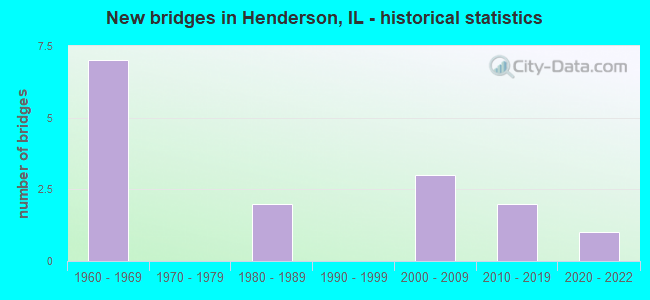
- New bridges - historical statistics
- 71960-1969
- 21980-1989
- 32000-2009
- 22010-2019
- 12020-2022


- Bridge Condition - Deck
- 11.1%Excellent
- 22.2%Very good
- 11.1%Good
- 22.2%Satisfactory
- 11.1%Fair
- 22.2%Serious

- Bridge Condition - Superstructure
- 9.1%Excellent
- 36.4%Very good
- 18.2%Good
- 18.2%Fair
- 18.2%Poor

- Bridge Condition - Substructure
- 9.1%Excellent
- 45.5%Very good
- 9.1%Good
- 18.2%Satisfactory
- 18.2%Fair

- Bridge Condition - Channel
- 55.6%Very good
- 11.1%Good
- 33.3%Satisfactory
Find on map >> Show street view
Structure Number: 480036, Location: .5 MI N HENDERSON CR (Lat: 41.078461, Lng: -90.334367), Route carried "on" structure: County highway , Year Built: 1966, Status: Open, Structure Length: 6.77m (22.21ft), Average Daily Traffic: 275 (year 2017), Truck Traffic: 4%, Average Future Daily Traffic: 200 (year 2032), Design Load: HS 15, Features Intersected: I-74, Facility Carried by Structure: ONTARIO ROAD
Minimum Vertical Clearance: 30+ m (98+ ft), Kilometerpoint: 3.927, Lanes on structure: 2, Lanes under structure: 4, Owner: State Highway Agency, Approaching Roadway Width: 11.0m (36.1ft), Material/Design: Steel continuous, Design/Construction: Stringer/Multi-beam, Number Of Spans In Main Unit: 4, Length of Maximum Span: 20.4m (66.9ft), Curb or Sidewalk Widths: Left: 0.6m (2.0ft), Right: 0.6m (2.0ft), Curb-To-Curb Width: 7.9m (25.9ft), Out-to-Out Width: 9.7m (31.8ft)
Condition: Deck: Serious, Superstructure: Poor, Substructure: Satisfactory, Operating Rating: 47.3 metric tons, Method Used To Determine Operating Rating: Load Factor (LF) rating reported by rating factor (RF) method using MS18 loading, Inventory Rating: 28.2 metric tons, Method Used To Determine Inventory Rating: Load Factor (LF) rating reported by rating factor (RF) method using MS18 loading, Structural Evaluation: Meets minimum limits, Deck Geometry: Somewhat better than minimum adequacy, Underclear: Meets minimum limits, Approach Roadway Alignment: Equal to present minimum criteria, Designated Inspection Frequency: Every 12 months, Inspection Date: December 2020, Deck Structure Type: Concrete Cast-file-Place
Find on map >> Show street view
Structure Number: 480061, Location: 2.5 MI W OF WATAGA (Lat: 41.024050, Lng: -90.334781), Route carried "on" structure: County highway , Year Built: 1965, Status: Open, Structure Length: 6.80m (22.31ft), Average Daily Traffic: 350 (year 2017), Truck Traffic: 6%, Average Future Daily Traffic: 251 (year 2032), Design Load: HS 15, Features Intersected: I-74, Facility Carried by Structure: HENDERSON RD (CH 3
Minimum Vertical Clearance: 30+ m (98+ ft), Kilometerpoint: 9.286, Lanes on structure: 2, Lanes under structure: 4, Owner: State Highway Agency, Approaching Roadway Width: 11.0m (36.1ft), Material/Design: Steel continuous, Design/Construction: Stringer/Multi-beam, Number Of Spans In Main Unit: 4, Length of Maximum Span: 20.4m (66.9ft), Curb or Sidewalk Widths: Left: 0.6m (2.0ft), Right: 0.6m (2.0ft), Curb-To-Curb Width: 7.3m (24.0ft), Out-to-Out Width: 9.1m (29.9ft)
Condition: Deck: Serious, Superstructure: Poor, Substructure: Fair, Operating Rating: 49.2 metric tons, Method Used To Determine Operating Rating: Load Factor (LF) rating reported by rating factor (RF) method using MS18 loading, Inventory Rating: 27.9 metric tons, Method Used To Determine Inventory Rating: Load Factor (LF) rating reported by rating factor (RF) method using MS18 loading, Structural Evaluation: Meets minimum limits, Deck Geometry: Somewhat better than minimum adequacy, Underclear: Meets minimum limits, Approach Roadway Alignment: Equal to present minimum criteria, Designated Inspection Frequency: Every 12 months, Inspection Date: December 2020, Deck Structure Type: Concrete Cast-file-Place
Find on map >> Show street view
Structure Number: 480062, Location: 2.5 MI S HENDERSON C (Lat: 41.034719, Lng: -90.334608), Route carried "on" structure: County highway , Year Built: 1965, Status: Open, Structure Length: 6.80m (22.31ft), Average Daily Traffic: 75 (year 2017), Truck Traffic: 13%, Average Future Daily Traffic: 75 (year 2032), Design Load: HS 15, Features Intersected: I-74, Facility Carried by Structure: TR 89
Minimum Vertical Clearance: 30+ m (98+ ft), Kilometerpoint: 3.042, Lanes on structure: 2, Lanes under structure: 4, Owner: State Highway Agency, Approaching Roadway Width: 7.9m (25.9ft), Material/Design: Steel continuous, Design/Construction: Stringer/Multi-beam, Number Of Spans In Main Unit: 4, Length of Maximum Span: 20.4m (66.9ft), Curb or Sidewalk Widths: Left: 0.6m (2.0ft), Right: 0.6m (2.0ft), Curb-To-Curb Width: 7.3m (24.0ft), Out-to-Out Width: 9.1m (29.9ft)
Condition: Deck: Good, Superstructure: Fair, Substructure: Satisfactory, Operating Rating: 56.1 metric tons, Method Used To Determine Operating Rating: Load Factor (LF) rating reported by rating factor (RF) method using MS18 loading, Inventory Rating: 31.4 metric tons, Method Used To Determine Inventory Rating: Load Factor (LF) rating reported by rating factor (RF) method using MS18 loading, Structural Evaluation: Somewhat better than minimum adequacy, Deck Geometry: Equal to present minimum criteria, Underclear: Meets minimum limits, Approach Roadway Alignment: Equal to present minimum criteria, Designated Inspection Frequency: Every 24 months, Inspection Date: Febuary 2020, Deck Structure Type: Concrete Cast-file-Place
Find on map >> Show street view
Structure Number: 48009, Location: 5.4 MI S HENRY CO LI (Lat: 41.073119, Lng: -90.334719), Route carried "on" structure: Interstate 74, Year Built: 2015, Status: Open, Structure Length: 3.28m (10.76ft), Average Daily Traffic: 7,500 (year 2021), Truck Traffic: 32%, Average Future Daily Traffic: 6,868 (year 2038), Design Load: HS 25 or greater, Features Intersected: HENDERSON CREEK
Minimum Vertical Clearance: 30+ m (98+ ft), Kilometerpoint: 66.191, Lanes on structure: 2, Base Highway Network: Yes, Owner: State Highway Agency, Approaching Roadway Width: 12.2m (40.0ft), Material/Design: Prestressed concrete, Design/Construction: Stringer/Multi-beam, Number Of Spans In Main Unit: 1, Length of Maximum Span: 31.6m (103.7ft), Curb-To-Curb Width: 12.2m (40.0ft), Out-to-Out Width: 13.2m (43.3ft)
Condition: Deck: Satisfactory, Superstructure: Very good, Substructure: Very good, Channel: Very good, Operating Rating: 71.0 metric tons, Method Used To Determine Operating Rating: Load and Resistance Factor Rating (LRFR) rating reported by rating factor(RF) method using HL-93 loadings, Inventory Rating: 54.8 metric tons, Method Used To Determine Inventory Rating: Load and Resistance Factor Rating (LRFR) rating reported by rating factor(RF) method using HL-93 loadings, Structural Evaluation: Equal to present desirable criteria, Deck Geometry: Better than present minimum criteria, Waterway Adequacy: Superior to present desirable criteria, Approach Roadway Alignment: Equal to present desirable criteria, Designated Inspection Frequency: Every 24 months, Inspection Date: November 2021, Deck Structure Type: Concrete Cast-file-Place, Wearing Surface/Protective System: Deck Protection: Epoxy Coated Reinforcing
Find on map >> Show street view
Structure Number: 480091, Location: 5.4 MI S HENRY CO LI (Lat: 41.072831, Lng: -90.334714), Route carried "on" structure: Interstate 74, Year Built: 2015, Status: Open, Structure Length: 3.16m (10.37ft), Average Daily Traffic: 7,500 (year 2021), Truck Traffic: 32%, Average Future Daily Traffic: 6,868 (year 2038), Design Load: HS 25 or greater, Features Intersected: HENDERSON CREEK
Minimum Vertical Clearance: 30+ m (98+ ft), Kilometerpoint: 66.223, Lanes on structure: 2, Base Highway Network: Yes, Owner: State Highway Agency, Approaching Roadway Width: 12.2m (40.0ft), Skew: 1 degrees, Material/Design: Prestressed concrete, Design/Construction: Stringer/Multi-beam, Number Of Spans In Main Unit: 1, Length of Maximum Span: 30.4m (99.7ft), Curb-To-Curb Width: 12.2m (40.0ft), Out-to-Out Width: 13.2m (43.3ft)
Condition: Deck: Satisfactory, Superstructure: Good, Substructure: Very good, Channel: Very good, Operating Rating: 71.6 metric tons, Method Used To Determine Operating Rating: Load and Resistance Factor Rating (LRFR) rating reported by rating factor(RF) method using HL-93 loadings, Inventory Rating: 55.1 metric tons, Method Used To Determine Inventory Rating: Load and Resistance Factor Rating (LRFR) rating reported by rating factor(RF) method using HL-93 loadings, Structural Evaluation: Better than present minimum criteria, Deck Geometry: Better than present minimum criteria, Waterway Adequacy: Superior to present desirable criteria, Approach Roadway Alignment: Equal to present desirable criteria, Designated Inspection Frequency: Every 24 months, Inspection Date: November 2021, Deck Structure Type: Concrete Cast-file-Place, Wearing Surface/Protective System: Deck Protection: Epoxy Coated Reinforcing
Find on map >> Show street view
Structure Number: 482005, Location: 3 MI N OF US 34 (Lat: 41.022122, Lng: -90.382281), Route carried "on" structure: US 150, Year Built: 2003, Status: Open, Structure Length: 0.70m (2.30ft), Average Daily Traffic: 2,500 (year 2021), Truck Traffic: 9%, Average Future Daily Traffic: 3,357 (year 2032), Design Load: HS 20, Features Intersected: S. HENDERSON CR TRIB
Minimum Vertical Clearance: 30+ m (98+ ft), Kilometerpoint: 51.916, Lanes on structure: 2, Owner: State Highway Agency, Approaching Roadway Width: 11.0m (36.1ft), Material/Design: Concrete, Design/Construction: Frame, Number Of Spans In Main Unit: 1, Length of Maximum Span: 6.5m (21.3ft), Curb-To-Curb Width: 11.0m (36.1ft), Out-to-Out Width: 11.0m (36.1ft)
Condition: Superstructure: Good, Substructure: Good, Channel: Satisfactory, Operating Rating: 89.1 metric tons, Method Used To Determine Operating Rating: Load Factor (LF) rating reported by rating factor (RF) method using MS18 loading, Inventory Rating: 56.1 metric tons, Method Used To Determine Inventory Rating: Load Factor (LF) rating reported by rating factor (RF) method using MS18 loading, Structural Evaluation: Better than present minimum criteria, Deck Geometry: Somewhat better than minimum adequacy, Waterway Adequacy: Equal to present desirable criteria, Approach Roadway Alignment: Equal to present desirable criteria, Designated Inspection Frequency: Every 48 months, Inspection Date: May 2020
Find on map >> Show street view
Structure Number: 483084, Location: E.CTR-35-T13NR1E (Lat: 41.070775, Lng: -90.343028), Route carried "on" structure: County highway , Year Built: 1967, Status: Open, Structure Length: 1.10m (3.61ft), Average Daily Traffic: 25 (year 2017), Average Future Daily Traffic: 25 (year 2032), Design Load: HS 15, Features Intersected: HENDERSON CREEK, Facility Carried by Structure: TR 76
Minimum Vertical Clearance: 30+ m (98+ ft), Kilometerpoint: 8.948, Lanes on structure: 2, Owner: Town or Township Highway Agency, Approaching Roadway Width: 4.9m (16.1ft), Material/Design: Concrete, Design/Construction: Channel Beam, Number Of Spans In Main Unit: 1, Length of Maximum Span: 10.7m (35.1ft), Curb-To-Curb Width: 6.2m (20.3ft), Out-to-Out Width: 6.9m (22.6ft)
Condition: Deck: Fair, Superstructure: Fair, Substructure: Fair, Channel: Satisfactory, Operating Rating: 48.3 metric tons, Method Used To Determine Operating Rating: Load Factor (LF) rating reported by rating factor (RF) method using MS18 loading, Inventory Rating: 28.8 metric tons, Method Used To Determine Inventory Rating: Load Factor (LF) rating reported by rating factor (RF) method using MS18 loading, Structural Evaluation: Somewhat better than minimum adequacy, Deck Geometry: Somewhat better than minimum adequacy, Waterway Adequacy: Equal to present minimum criteria, Approach Roadway Alignment: Better than present minimum criteria, Designated Inspection Frequency: Every 24 months, Inspection Date: March 2021, Deck Structure Type: Concrete Precast Panels, Wearing Surface/Protective System: Wearing Surface: Bituminous
Find on map >> Show street view
Structure Number: 483322, Location: NE-15-T12NR1E (Lat: 41.029797, Lng: -90.365861), Route carried "on" structure: County highway , Year Built: 1989, Status: Open, Structure Length: 1.57m (5.15ft), Average Daily Traffic: 125 (year 2017), Truck Traffic: 8%, Average Future Daily Traffic: 175 (year 2032), Design Load: HS 20, Features Intersected: TRIB. S HENDERSON CR, Facility Carried by Structure: TR 56A
Minimum Vertical Clearance: 30+ m (98+ ft), Kilometerpoint: 5.810, Lanes on structure: 2, Owner: Town or Township Highway Agency, Approaching Roadway Width: 7.3m (24.0ft), Material/Design: Prestressed concrete, Design/Construction: Box Beam or Girders - Multiple, Number Of Spans In Main Unit: 1, Length of Maximum Span: 14.9m (48.9ft), Curb-To-Curb Width: 7.3m (24.0ft), Out-to-Out Width: 7.3m (24.0ft)
Condition: Deck: Very good, Superstructure: Very good, Substructure: Very good, Channel: Good, Operating Rating: 44.4 metric tons, Method Used To Determine Operating Rating: Assigned rating based on Load Factor Design (LFD) reported by rating factor (RF) using MS18 loading, Inventory Rating: 32.4 metric tons, Method Used To Determine Inventory Rating: Assigned rating based on Load Factor Design (LFD) reported by rating factor (RF) using MS18 loading, Structural Evaluation: Equal to present desirable criteria, Deck Geometry: Somewhat better than minimum adequacy, Waterway Adequacy: Better than present minimum criteria, Approach Roadway Alignment: Better than present minimum criteria, Designated Inspection Frequency: Every 48 months, Inspection Date: Febuary 2021, Deck Structure Type: Concrete Precast Panels, Wearing Surface/Protective System: Wearing Surface: Bituminous, Membrane: Built-up
Find on map >> Show street view
Structure Number: 483377, Location: E CTR-23-T12NR1E (Lat: 41.013286, Lng: -90.347022), Route carried "on" structure: County highway , Year Built: 2002, Status: Open, Structure Length: 1.26m (4.13ft), Average Daily Traffic: 125 (year 2017), Truck Traffic: 16%, Average Future Daily Traffic: 125 (year 2032), Design Load: HS 20, Features Intersected: S HENDERSON CREEK, Facility Carried by Structure: TR 76A
Minimum Vertical Clearance: 30+ m (98+ ft), Kilometerpoint: 0.772, Lanes on structure: 2, Owner: Town or Township Highway Agency, Approaching Roadway Width: 7.3m (24.0ft), Material/Design: Prestressed concrete, Design/Construction: Box Beam or Girders - Multiple, Number Of Spans In Main Unit: 1, Length of Maximum Span: 11.9m (39.0ft), Curb-To-Curb Width: 7.3m (24.0ft), Out-to-Out Width: 7.3m (24.0ft)
Condition: Deck: Very good, Superstructure: Very good, Substructure: Very good, Channel: Very good, Operating Rating: 44.1 metric tons, Method Used To Determine Operating Rating: Assigned rating based on Load Factor Design (LFD) reported by rating factor (RF) using MS18 loading, Inventory Rating: 32.4 metric tons, Method Used To Determine Inventory Rating: Assigned rating based on Load Factor Design (LFD) reported by rating factor (RF) using MS18 loading, Structural Evaluation: Equal to present desirable criteria, Deck Geometry: Somewhat better than minimum adequacy, Waterway Adequacy: Equal to present desirable criteria, Approach Roadway Alignment: Equal to present desirable criteria, Designated Inspection Frequency: Every 48 months, Inspection Date: Febuary 2022, Deck Structure Type: Concrete Precast Panels, Wearing Surface/Protective System: Wearing Surface: Bituminous, Membrane: Built-up
Find on map >> Show street view
Structure Number: 483381, Location: SW-23.T12NR1E (Lat: 41.013089, Lng: -90.356672), Route carried "on" structure: County highway , Year Built: 2005, Status: Open, Structure Length: 1.04m (3.41ft), Average Daily Traffic: 950 (year 2017), Truck Traffic: 7%, Average Future Daily Traffic: 902 (year 2032), Design Load: HS 20, Features Intersected: HENDERSON CREEK, Facility Carried by Structure: CO HWY 1
Minimum Vertical Clearance: 30+ m (98+ ft), Kilometerpoint: 0.869, Lanes on structure: 2, Owner: County Highway Agency, Approaching Roadway Width: 7.3m (24.0ft), Material/Design: Concrete, Design/Construction: Frame, Number Of Spans In Main Unit: 1, Length of Maximum Span: 9.8m (32.2ft)
Condition: Superstructure: Very good, Substructure: Very good, Channel: Very good, Operating Rating: 44.1 metric tons, Method Used To Determine Operating Rating: Assigned rating based on Load Factor Design (LFD) reported by rating factor (RF) using MS18 loading, Inventory Rating: 32.4 metric tons, Method Used To Determine Inventory Rating: Assigned rating based on Load Factor Design (LFD) reported by rating factor (RF) using MS18 loading, Structural Evaluation: Equal to present desirable criteria, Waterway Adequacy: Equal to present desirable criteria, Approach Roadway Alignment: Superior to present desirable criteria, Designated Inspection Frequency: Every 48 months, Inspection Date: January 2022
Find on map >> Show street view
Structure Number: 483409, Location: SE-26-T13NR1E (Lat: 41.081864, Lng: -90.342872), Route carried "on" structure: County highway , Year Built: 2021, Status: Open, Structure Length: 1.77m (5.81ft), Average Daily Traffic: 25 (year 2017), Average Future Daily Traffic: 25 (year 2027), Design Load: HS 25 or greater, Features Intersected: TRIB TO HENDERSON CK, Facility Carried by Structure: TR 76
Minimum Vertical Clearance: 30+ m (98+ ft), Kilometerpoint: 7.709, Lanes on structure: 2, Owner: Town or Township Highway Agency, Approaching Roadway Width: 5.5m (18.0ft), Material/Design: Prestressed concrete, Design/Construction: Box Beam or Girders - Multiple, Number Of Spans In Main Unit: 1, Length of Maximum Span: 17.1m (56.1ft), Curb-To-Curb Width: 7.3m (24.0ft), Out-to-Out Width: 7.3m (24.0ft)
Condition: Deck: Excellent, Superstructure: Excellent, Substructure: Excellent, Channel: Very good, Deck Geometry: Equal to present minimum criteria, Waterway Adequacy: Better than present minimum criteria, Approach Roadway Alignment: Better than present minimum criteria, Designated Inspection Frequency: Every 24 months, Inspection Date: December 2021, Deck Structure Type: Concrete Precast Panels
Find on map >> Show street view
Structure Number: 485023, Location: NW-6-T12NR2E (Lat: 41.057933, Lng: -90.324181), Route carried "on" structure: County highway , Year Built: 1985, Status: Open, Structure Length: 0.67m (2.20ft), Average Daily Traffic: 75 (year 2017), Truck Traffic: 13%, Average Future Daily Traffic: 75 (year 2032), Design Load: HS 20, Features Intersected: STREAM, Facility Carried by Structure: TR 84
Minimum Vertical Clearance: 30+ m (98+ ft), Kilometerpoint: 10.396, Lanes on structure: 2, Owner: Town or Township Highway Agency, Approaching Roadway Width: 7.9m (25.9ft), Skew: 3 degrees, Material/Design: Steel, Design/Construction: Culvert, Number Of Spans In Main Unit: 2, Length of Maximum Span: 2.7m (8.9ft)
Condition: Channel: Satisfactory, Culverts: Good, Operating Rating: 44.7 metric tons, Method Used To Determine Operating Rating: Load Factor (LF) rating reported by rating factor (RF) method using MS18 loading, Inventory Rating: 26.9 metric tons, Method Used To Determine Inventory Rating: Load Factor (LF) rating reported by rating factor (RF) method using MS18 loading, Structural Evaluation: Equal to present minimum criteria, Waterway Adequacy: Better than present minimum criteria, Approach Roadway Alignment: Better than present minimum criteria, Designated Inspection Frequency: Every 24 months, Inspection Date: January 2022
Find on map >> Show street view
Structure Number: 480036, Location: .5 MI N HENDERSON CR (Lat: 41.078461, Lng: -90.334367), Route carried "under" structure: Interstate 74, Year Built: 1966, Structure Length: 0. m, Average Daily Traffic: 15,000 (year 2021), Truck Traffic: 32%, Features Intersected: I-74, Facility Carried by Structure: ONTARIO ROAD
Minimum Vertical Clearance: 4.93m (16.17ft), Kilometerpoint: 65.595, Lanes on structure: 2, Lanes under structure: 4, Material/Design: Steel continuous, Design/Construction: Stringer/Multi-beam, Length of Maximum Span: 20.4m (66.9ft)
Find on map >> Show street view
Structure Number: 480061, Location: 2.5 MI W OF WATAGA (Lat: 41.024050, Lng: -90.334781), Route carried "under" structure: Interstate 74, Year Built: 1965, Structure Length: 0. m, Average Daily Traffic: 15,000 (year 2021), Truck Traffic: 32%, Features Intersected: I-74, Facility Carried by Structure: HENDERSON RD (CH 3
Minimum Vertical Clearance: 4.90m (16.08ft), Kilometerpoint: 71.646, Lanes on structure: 2, Lanes under structure: 4, Material/Design: Steel continuous, Design/Construction: Stringer/Multi-beam, Length of Maximum Span: 20.4m (66.9ft)
Find on map >> Show street view
Structure Number: 480062, Location: 2.5 MI S HENDERSON C (Lat: 41.034719, Lng: -90.334608), Route carried "under" structure: Interstate 74, Year Built: 1965, Structure Length: 0. m, Average Daily Traffic: 15,000 (year 2021), Truck Traffic: 32%, Features Intersected: I-74, Facility Carried by Structure: TR 89
Minimum Vertical Clearance: 5.00m (16.40ft), Kilometerpoint: 70.455, Lanes on structure: 2, Lanes under structure: 4, Material/Design: Steel continuous, Design/Construction: Stringer/Multi-beam, Length of Maximum Span: 20.4m (66.9ft)