Bridge Statistics for Hemlock, Michigan (MI)
Condition, Traffic, Stress, Structural Evaluation, Project Costs
- National Bridge Inventory (NBI) Statistics
- 15Number of bridges
- 43ft / 13.3mTotal length
- $560,000Total costs
- 11,641Total average daily traffic
- 565Total average daily truck traffic
- 13,182Total future (year 2013) average daily traffic
- National Bridge Inventory (NBI) Registered Bridges for Hemlock
- No street view available for this location
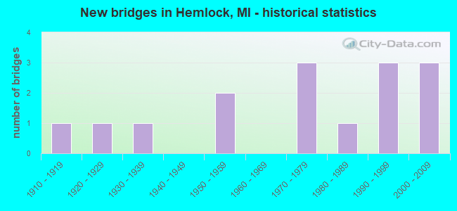
- New bridges - historical statistics
- 11910-1919
- 11920-1929
- 11930-1939
- 21950-1959
- 31970-1979
- 11980-1989
- 31990-1999
- 32000-2009

- Reconstructed bridges - Historical Statistics
- 11950-1959
- 01960-1969
- 01970-1979
- 11980-1989


- Bridge Condition - Deck
- 28.6%Good
- 14.3%Satisfactory
- 42.9%Fair
- 14.3%Serious

- Bridge Condition - Superstructure
- 28.6%Good
- 14.3%Satisfactory
- 42.9%Fair
- 14.3%Serious

- Bridge Condition - Substructure
- 14.3%Very good
- 42.9%Good
- 14.3%Fair
- 14.3%Serious
- 14.3%Critical

- Bridge Condition - Channel
- 20.0%Good
- 60.0%Satisfactory
- 6.7%Fair
- 6.7%Poor
- 6.7%Serious

- Bridge Condition - Culverts
- 50.0%Good
- 12.5%Satisfactory
- 25.0%Fair
- 12.5%Poor
Find on map >> Show street view
Structure Number: 6972, Location: 0.25 MI W OF SCHREIBER RD (Lat: 43.481761, Lng: -84.215586), Route carried "on" structure: County highway , Year Built: 1980, Status: Open, Structure Length: 0.85m (2.79ft), Average Daily Traffic: 1,896 (year 2018), Truck Traffic: 5%, Average Future Daily Traffic: 2,817 (year 2038), Design Load: HS 20+Mod, Features Intersected: WEEKS DRAIN, Facility Carried by Structure: TITTABAWASSEE ROAD
Minimum Vertical Clearance: 30.48m (100.00ft), Kilometerpoint: 12.470, Lanes on structure: 2, Owner: County Highway Agency, Approaching Roadway Width: 8.5m (27.9ft), Skew: 3 degrees, Material/Design: Steel, Design/Construction: Culvert, Number Of Spans In Main Unit: 1, Length of Maximum Span: 8.5m (27.9ft)
Condition: Channel: Poor, Culverts: Poor, Operating Rating: 54.1 metric tons, Method Used To Determine Operating Rating: Load Factor (LF) rating reported by rating factor (RF) method using MS18 loading, Inventory Rating: 48.0 metric tons, Method Used To Determine Inventory Rating: Load Factor (LF) rating reported by rating factor (RF) method using MS18 loading, Structural Evaluation: Meets minimum limits, Waterway Adequacy: Equal to present minimum criteria, Approach Roadway Alignment: Equal to present desirable criteria, Designated Inspection Frequency: Every 12 months, Inspection Date: August 2021
Find on map >> Show street view
Structure Number: 6977, Location: 0.5 MI S OF LAPORTE RD (Lat: 43.488792, Lng: -84.249800), Route carried "on" structure: County highway , Year Built: 1929, Year Reconstructed: 1955, Status: Open, Structure Length: 0.76m (2.49ft), Average Daily Traffic: 291 (year 1999), Truck Traffic: 7%, Average Future Daily Traffic: 433 (year 2019), Design Load: HS 20+Mod, Features Intersected: FLEMMING DRAIN, Facility Carried by Structure: POSEYVILLE ROAD
Minimum Vertical Clearance: 30.48m (100.00ft), Kilometerpoint: 0.795, Lanes on structure: 2, Owner: County Highway Agency, Approaching Roadway Width: 7.3m (24.0ft), Material/Design: Steel, Design/Construction: Stringer/Multi-beam, Number Of Spans In Main Unit: 1, Length of Maximum Span: 6.7m (22.0ft), Curb-To-Curb Width: 7.3m (24.0ft), Out-to-Out Width: 7.4m (24.3ft)
Condition: Deck: Serious, Superstructure: Serious, Substructure: Fair, Channel: Satisfactory, Operating Rating: 61.9 metric tons, Method Used To Determine Operating Rating: Load Factor (LF) rating reported by rating factor (RF) method using MS18 loading, Inventory Rating: 37.3 metric tons, Method Used To Determine Inventory Rating: Load Factor (LF) rating reported by rating factor (RF) method using MS18 loading, Structural Evaluation: High priority of corrective action, Deck Geometry: Somewhat better than minimum adequacy, Waterway Adequacy: Equal to present minimum criteria, Approach Roadway Alignment: Equal to present desirable criteria, Designated Inspection Frequency: Every 12 months, Inspection Date: August 2021, Deck Structure Type: Concrete Cast-file-Place, Wearing Surface/Protective System: Wearing Surface: Bituminous
Find on map >> Show street view
Structure Number: 698, Location: 0.2 MI N OF TITTABAWASSEE (Lat: 43.484742, Lng: -84.210208), Route carried "on" structure: County highway , Year Built: 1930, Year Reconstructed: 1986, Status: Open, Structure Length: 1.03m (3.38ft), Average Daily Traffic: 51 (year 1999), Average Future Daily Traffic: 50 (year 2013), Design Load: HS 20+Mod, Features Intersected: WEEKS DRAIN, Facility Carried by Structure: SCHREIBER ROAD
Minimum Vertical Clearance: 30.48m (100.00ft), Kilometerpoint: 0.330, Lanes on structure: 2, Owner: County Highway Agency, Approaching Roadway Width: 7.0m (23.0ft), Material/Design: Steel, Design/Construction: Stringer/Multi-beam, Number Of Spans In Main Unit: 1, Length of Maximum Span: 9.1m (29.9ft), Curb-To-Curb Width: 7.9m (25.9ft), Out-to-Out Width: 8.0m (26.2ft)
Condition: Deck: Fair, Superstructure: Fair, Substructure: Serious, Channel: Good, Operating Rating: 46.1 metric tons, Method Used To Determine Operating Rating: Load Factor (LF), Inventory Rating: 27.6 metric tons, Method Used To Determine Inventory Rating: Load Factor (LF), Structural Evaluation: High priority of corrective action, Deck Geometry: Equal to present minimum criteria, Waterway Adequacy: Equal to present minimum criteria, Approach Roadway Alignment: Equal to present desirable criteria, Designated Inspection Frequency: Every 12 months, Inspection Date: August 2021, Deck Structure Type: Concrete Cast-file-Place, Wearing Surface/Protective System: Wearing Surface: Bituminous
Find on map >> Show street view
Structure Number: 9225, Location: 0.6 MI E OF BRENNAN ROAD (Lat: 43.450411, Lng: -84.236203), Route carried "on" structure: County highway , Year Built: 1995, Status: Open, Structure Length: 0.85m (2.79ft), Average Daily Traffic: 1,254 (year 2008), Truck Traffic: 5%, Average Future Daily Traffic: 1,317 (year 2018), Design Load: HS 20, Features Intersected: WHITMORE DRAIN, Facility Carried by Structure: FROST ROAD
Minimum Vertical Clearance: 30.48m (100.00ft), Kilometerpoint: 10.834, Lanes on structure: 2, Owner: County Highway Agency, Approaching Roadway Width: 11.6m (38.1ft), Skew: 3 degrees, Material/Design: Concrete, Design/Construction: Culvert, Number Of Spans In Main Unit: 1, Length of Maximum Span: 8.5m (27.9ft), Curb-To-Curb Width: 12.1m (39.7ft), Out-to-Out Width: 12.8m (42.0ft)
Condition: Channel: Good, Culverts: Good, Operating Rating: 64.5 metric tons, Method Used To Determine Operating Rating: Load Factor (LF) rating reported by rating factor (RF) method using MS18 loading, Inventory Rating: 38.6 metric tons, Method Used To Determine Inventory Rating: Load Factor (LF) rating reported by rating factor (RF) method using MS18 loading, Structural Evaluation: Better than present minimum criteria, Deck Geometry: Equal to present minimum criteria, Waterway Adequacy: Equal to present minimum criteria, Approach Roadway Alignment: Better than present minimum criteria, Designated Inspection Frequency: Every 24 months, Inspection Date: August 2021, Deck Structure Type: Concrete Cast-file-Place, Wearing Surface/Protective System: Wearing Surface: Monolithic Concrete, Deck Protection: Epoxy Coated Reinforcing
Find on map >> Show street view
Structure Number: 9242, Location: 0.1 MI N OF FROST ROAD (Lat: 43.451275, Lng: -84.230158), Route carried "on" structure: County highway 7323, Year Built: 1956, Status: Open, Structure Length: 0.91m (2.99ft), Average Daily Traffic: 3,633 (year 2010), Truck Traffic: 5%, Average Future Daily Traffic: 3,815 (year 2020), Design Load: H 20, Features Intersected: WHITMORE DRAIN, Facility Carried by Structure: HEMLOCK ROAD
Minimum Vertical Clearance: 30.48m (100.00ft), Kilometerpoint: 6.487, Lanes on structure: 2, Owner: County Highway Agency, Approaching Roadway Width: 11.6m (38.1ft), Material/Design: Steel, Design/Construction: Stringer/Multi-beam, Number Of Spans In Main Unit: 1, Length of Maximum Span: 8.2m (26.9ft), Curb-To-Curb Width: 7.3m (24.0ft), Out-to-Out Width: 9.7m (31.8ft)
Condition: Deck: Satisfactory, Superstructure: Satisfactory, Substructure: Good, Channel: Satisfactory, Operating Rating: 72.7 metric tons, Method Used To Determine Operating Rating: Allowable Stress (AS), Inventory Rating: 34.5 metric tons, Method Used To Determine Inventory Rating: Allowable Stress (AS), Structural Evaluation: Equal to present minimum criteria, Deck Geometry: High priority of replacement, Waterway Adequacy: Equal to present minimum criteria, Approach Roadway Alignment: Equal to present desirable criteria, Designated Inspection Frequency: Every 24 months, Inspection Date: September 2020, Deck Structure Type: Concrete Cast-file-Place, Wearing Surface/Protective System: Wearing Surface: Bituminous
Find on map >> Show street view
Structure Number: 9243, Location: 0.7 MI N OF DICE ROAD (Lat: 43.478278, Lng: -84.230319), Route carried "on" structure: County highway 7323, Year Built: 1956, Status: Open, Structure Length: 1.22m (4.00ft), Average Daily Traffic: 3,480 (year 2010), Truck Traffic: 5%, Average Future Daily Traffic: 3,654 (year 2020), Design Load: HS 20+Mod, Features Intersected: WEEKS DRAIN, Facility Carried by Structure: HEMLOCK ROAD
Minimum Vertical Clearance: 30.48m (100.00ft), Kilometerpoint: 9.487, Lanes on structure: 2, Owner: County Highway Agency, Approaching Roadway Width: 11.6m (38.1ft), Material/Design: Steel, Design/Construction: Stringer/Multi-beam, Number Of Spans In Main Unit: 1, Length of Maximum Span: 11.2m (36.7ft), Curb-To-Curb Width: 7.3m (24.0ft), Out-to-Out Width: 9.1m (29.9ft)
Condition: Deck: Fair, Superstructure: Fair, Substructure: Good, Channel: Fair, Operating Rating: 59.1 metric tons, Method Used To Determine Operating Rating: Allowable Stress (AS), Inventory Rating: 26.4 metric tons, Method Used To Determine Inventory Rating: Allowable Stress (AS), Structural Evaluation: Somewhat better than minimum adequacy, Deck Geometry: High priority of replacement, Waterway Adequacy: Equal to present minimum criteria, Approach Roadway Alignment: Equal to present desirable criteria, Designated Inspection Frequency: Every 24 months, Inspection Date: September 2020, Deck Structure Type: Concrete Cast-file-Place, Wearing Surface/Protective System: Wearing Surface: Bituminous
Find on map >> Show street view
Structure Number: 9384, Location: 0.8 MI E OF IVA ROAD (Lat: 43.442533, Lng: -84.252375), Route carried "on" structure: ServiceCounty highway , Year Built: 2001, Status: Open, Structure Length: 0.91m (2.99ft), Average Daily Traffic: 136 (year 2010), Truck Traffic: 5%, Average Future Daily Traffic: 143 (year 2020), Design Load: HS 20, Features Intersected: WHITMORE DRAIN, Facility Carried by Structure: LUNNEY ROAD
Minimum Vertical Clearance: 30.48m (100.00ft), Kilometerpoint: 1.835, Lanes on structure: 2, Owner: County Highway Agency, Approaching Roadway Width: 8.2m (26.9ft), Skew: 1 degrees, Material/Design: Prestressed concrete, Design/Construction: Box Beam or Girders - Multiple, Number Of Spans In Main Unit: 1, Length of Maximum Span: 9.1m (29.9ft), Curb-To-Curb Width: 8.2m (26.9ft), Out-to-Out Width: 8.5m (27.9ft)
Condition: Deck: Good, Superstructure: Good, Substructure: Very good, Channel: Satisfactory, Operating Rating: 97.2 metric tons, Method Used To Determine Operating Rating: Load Factor (LF) rating reported by rating factor (RF) method using MS18 loading, Inventory Rating: 58.6 metric tons, Method Used To Determine Inventory Rating: Load Factor (LF) rating reported by rating factor (RF) method using MS18 loading, Structural Evaluation: Better than present minimum criteria, Waterway Adequacy: Equal to present minimum criteria, Approach Roadway Alignment: Equal to present desirable criteria, Designated Inspection Frequency: Every 24 months, Inspection Date: August 2020, Deck Structure Type: Concrete Cast-file-Place, Wearing Surface/Protective System: Wearing Surface: Bituminous
Find on map >> Show street view
Structure Number: 9385, Location: 0.9 MI E OF STEEL ROAD (Lat: 43.463300, Lng: -84.270878), Route carried "on" structure: ServiceCounty highway , Year Built: 1973, Status: Open, Structure Length: 0.79m (2.59ft), Average Daily Traffic: 234 (year 2010), Truck Traffic: 5%, Average Future Daily Traffic: 246 (year 2020), Design Load: HS 20+Mod, Features Intersected: WEEKS DRAIN, Facility Carried by Structure: DICE ROAD
Minimum Vertical Clearance: 30.48m (100.00ft), Kilometerpoint: 8.016, Lanes on structure: 2, Owner: County Highway Agency, Approaching Roadway Width: 13.1m (43.0ft), Material/Design: Steel, Design/Construction: Culvert, Number Of Spans In Main Unit: 1, Length of Maximum Span: 6.4m (21.0ft), Curb-To-Curb Width: 8.5m (27.9ft), Out-to-Out Width: 13.1m (43.0ft)
Condition: Channel: Satisfactory, Culverts: Fair, Operating Rating: 62.2 metric tons, Method Used To Determine Operating Rating: Load Factor (LF) rating reported by rating factor (RF) method using MS18 loading, Inventory Rating: 37.3 metric tons, Method Used To Determine Inventory Rating: Load Factor (LF) rating reported by rating factor (RF) method using MS18 loading, Structural Evaluation: Somewhat better than minimum adequacy, Deck Geometry: Equal to present minimum criteria, Waterway Adequacy: Equal to present desirable criteria, Approach Roadway Alignment: Equal to present desirable criteria, Designated Inspection Frequency: Every 24 months, Inspection Date: September 2020
Find on map >> Show street view
Structure Number: 9386, Location: 0.3 MI E OF FEHN ROAD (Lat: 43.465917, Lng: -84.214636), Route carried "on" structure: ServiceCounty highway , Year Built: 2003, Status: Open, Structure Length: 1.22m (4.00ft), Average Daily Traffic: 86 (year 2010), Truck Traffic: 5%, Average Future Daily Traffic: 90 (year 2020), Design Load: HS 20, Features Intersected: WHITMORE DRAIN, Facility Carried by Structure: DICE ROAD
Minimum Vertical Clearance: 30.48m (100.00ft), Kilometerpoint: 12.576, Lanes on structure: 2, Owner: County Highway Agency, Approaching Roadway Width: 7.9m (25.9ft), Skew: 1 degrees, Material/Design: Prestressed concrete, Design/Construction: Box Beam or Girders - Multiple, Number Of Spans In Main Unit: 1, Length of Maximum Span: 11.0m (36.1ft), Curb-To-Curb Width: 7.9m (25.9ft), Out-to-Out Width: 9.6m (31.5ft)
Condition: Deck: Good, Superstructure: Good, Substructure: Good, Channel: Satisfactory, Operating Rating: 62.2 metric tons, Method Used To Determine Operating Rating: Load Factor (LF), Inventory Rating: 29.0 metric tons, Method Used To Determine Inventory Rating: Load Factor (LF), Structural Evaluation: Better than present minimum criteria, Deck Geometry: Equal to present minimum criteria, Waterway Adequacy: Equal to present desirable criteria, Approach Roadway Alignment: Equal to present desirable criteria, Designated Inspection Frequency: Every 24 months, Inspection Date: March 2020, Deck Structure Type: Concrete Cast-file-Place, Wearing Surface/Protective System: Wearing Surface: Monolithic Concrete, Deck Protection: Epoxy Coated Reinforcing
Find on map >> Show street view
Structure Number: 9387, Location: 0.5 MI N OF FROST ROAD (Lat: 43.454394, Lng: -84.290647), Route carried "on" structure: ServiceCounty highway , Year Built: 1973, Status: Open, Structure Length: 0.73m (2.40ft), Average Daily Traffic: 171 (year 2010), Truck Traffic: 5%, Average Future Daily Traffic: 180 (year 2020), Design Load: H 20, Features Intersected: WEEKS DRAIN, Facility Carried by Structure: STEEL ROAD
Minimum Vertical Clearance: 30.48m (100.00ft), Kilometerpoint: 12.935, Lanes on structure: 2, Owner: County Highway Agency, Approaching Roadway Width: 9.1m (29.9ft), Material/Design: Steel, Design/Construction: Culvert, Number Of Spans In Main Unit: 1, Length of Maximum Span: 6.4m (21.0ft), Curb-To-Curb Width: 8.8m (28.9ft), Out-to-Out Width: 13.1m (43.0ft)
Condition: Channel: Satisfactory, Culverts: Fair, Operating Rating: 37.6 metric tons, Method Used To Determine Operating Rating: Load Factor (LF) rating reported by rating factor (RF) method using MS18 loading, Inventory Rating: 30.5 metric tons, Method Used To Determine Inventory Rating: Load Factor (LF) rating reported by rating factor (RF) method using MS18 loading, Structural Evaluation: Somewhat better than minimum adequacy, Deck Geometry: Equal to present minimum criteria, Waterway Adequacy: Equal to present minimum criteria, Approach Roadway Alignment: Equal to present desirable criteria, Designated Inspection Frequency: Every 24 months, Inspection Date: August 2021, Deck Structure Type: Other, Wearing Surface/Protective System: Wearing Surface: Gravel
Find on map >> Show street view
Structure Number: 9388, Location: 0.2 MI N OF GEDDES ROAD (Lat: 43.430833, Lng: -84.269306), Route carried "on" structure: ServiceCounty highway , Year Built: 1975, Status: Open, Structure Length: 0.91m (2.99ft), Average Daily Traffic: 185 (year 2010), Average Future Daily Traffic: 194 (year 2020), Design Load: H 20, Features Intersected: WHITMORE DRAIN, Facility Carried by Structure: IVA ROAD
Minimum Vertical Clearance: 30.48m (100.00ft), Kilometerpoint: 4.410, Lanes on structure: 2, Owner: County Highway Agency, Approaching Roadway Width: 12.0m (39.4ft), Skew: 1 degrees, Material/Design: Steel, Design/Construction: Culvert, Number Of Spans In Main Unit: 1, Length of Maximum Span: 8.2m (26.9ft), Curb-To-Curb Width: 11.0m (36.1ft), Out-to-Out Width: 13.4m (44.0ft)
Condition: Channel: Satisfactory, Culverts: Satisfactory, Operating Rating: 97.2 metric tons, Method Used To Determine Operating Rating: Load Factor (LF) rating reported by rating factor (RF) method using MS18 loading, Inventory Rating: 97.2 metric tons, Method Used To Determine Inventory Rating: Load Factor (LF) rating reported by rating factor (RF) method using MS18 loading, Structural Evaluation: Equal to present minimum criteria, Deck Geometry: Equal to present desirable criteria, Waterway Adequacy: Equal to present desirable criteria, Approach Roadway Alignment: Equal to present desirable criteria, Designated Inspection Frequency: Every 24 months, Inspection Date: August 2021
Find on map >> Show street view
Structure Number: 9389, Location: 0.1 MI N OF DICE ROAD (Lat: 43.464497, Lng: -84.269658), Route carried "on" structure: ServiceCounty highway , Year Built: 1992, Status: Posted for load, Structure Length: 0.64m (2.10ft), Average Daily Traffic: 76 (year 2010), Truck Traffic: 5%, Average Future Daily Traffic: 80 (year 2020), Design Load: H 10, Features Intersected: WEEKS DRAIN, Facility Carried by Structure: IVA ROAD
Minimum Vertical Clearance: 30.48m (100.00ft), Kilometerpoint: 8.148, Lanes on structure: 2, Owner: County Highway Agency, Approaching Roadway Width: 5.0m (16.4ft), Skew: 1 degrees, Material/Design: Steel, Design/Construction: Culvert, Number Of Spans In Main Unit: 1, Length of Maximum Span: 6.1m (20.0ft), Curb-To-Curb Width: 7.0m (23.0ft), Out-to-Out Width: 15.2m (49.9ft)
Condition: Channel: Good, Culverts: Good, Operating Rating: 8.4 metric tons, Method Used To Determine Operating Rating: Load Factor (LF) rating reported by rating factor (RF) method using MS18 loading, Inventory Rating: 5.5 metric tons, Method Used To Determine Inventory Rating: Load Factor (LF) rating reported by rating factor (RF) method using MS18 loading, Structural Evaluation: High priority of corrective action, Waterway Adequacy: Somewhat better than minimum adequacy, Approach Roadway Alignment: Equal to present minimum criteria, Bridge Posting: Required (Relationship of Operating Rating to Maximum Legal Load: > 39.9% below), Designated Inspection Frequency: Every 24 months, Inspection Date: August 2021, Deck Structure Type: Concrete Cast-file-Place, Wearing Surface/Protective System: Wearing Surface: Bituminous
Find on map >> Show street view
Structure Number: 9392, Location: 0.5 MI N OF DICE ROAD (Lat: 43.473703, Lng: -84.240119), Route carried "on" structure: ServiceCounty highway , Year Built: 1991, Status: Open, Structure Length: 0.85m (2.79ft), Average Daily Traffic: 43 (year 2010), Truck Traffic: 5%, Average Future Daily Traffic: 45 (year 2020), Design Load: HS 20+Mod, Features Intersected: WEEKS DRAIN, Facility Carried by Structure: DIENER ROAD
Minimum Vertical Clearance: 30.48m (100.00ft), Kilometerpoint: 0.996, Lanes on structure: 2, Owner: County Highway Agency, Approaching Roadway Width: 8.0m (26.2ft), Skew: 1 degrees, Material/Design: Concrete, Design/Construction: Culvert, Number Of Spans In Main Unit: 1, Length of Maximum Span: 7.9m (25.9ft), Curb-To-Curb Width: 8.0m (26.2ft), Out-to-Out Width: 8.5m (27.9ft)
Condition: Channel: Satisfactory, Culverts: Good, Operating Rating: 69.0 metric tons, Method Used To Determine Operating Rating: Load Factor (LF) rating reported by rating factor (RF) method using MS18 loading, Inventory Rating: 41.5 metric tons, Method Used To Determine Inventory Rating: Load Factor (LF) rating reported by rating factor (RF) method using MS18 loading, Structural Evaluation: Better than present minimum criteria, Deck Geometry: Equal to present minimum criteria, Waterway Adequacy: Better than present minimum criteria, Approach Roadway Alignment: Better than present minimum criteria, Designated Inspection Frequency: Every 24 months, Inspection Date: August 2021, Deck Structure Type: Concrete Precast Panels, Wearing Surface/Protective System: Wearing Surface: Gravel, Membrane: Epoxy
Find on map >> Show street view
Structure Number: 9393, Location: 0.5 MI N OF FROST ROAD (Lat: 43.458600, Lng: -84.220369), Route carried "on" structure: ServiceCounty highway , Year Built: 2004, Status: Open, Structure Length: 0.73m (2.40ft), Average Daily Traffic: 95 (year 2010), Average Future Daily Traffic: 100 (year 2020), Design Load: HS 20, Features Intersected: WHITMORE DRAIN, Facility Carried by Structure: FEHN ROAD
Minimum Vertical Clearance: 30.48m (100.00ft), Kilometerpoint: 0.829, Lanes on structure: 2, Owner: County Highway Agency, Approaching Roadway Width: 6.7m (22.0ft), Skew: 2 degrees, Material/Design: Concrete, Design/Construction: Culvert, Number Of Spans In Main Unit: 1, Length of Maximum Span: 7.3m (24.0ft), Out-to-Out Width: 5.4m (17.7ft)
Condition: Channel: Satisfactory, Culverts: Good, Operating Rating: 68.0 metric tons, Method Used To Determine Operating Rating: Load Factor (LF) rating reported by rating factor (RF) method using MS18 loading, Inventory Rating: 40.8 metric tons, Method Used To Determine Inventory Rating: Load Factor (LF) rating reported by rating factor (RF) method using MS18 loading, Structural Evaluation: Better than present minimum criteria, Waterway Adequacy: Better than present minimum criteria, Approach Roadway Alignment: Somewhat better than minimum adequacy, Designated Inspection Frequency: Every 24 months, Inspection Date: November 2020, Wearing Surface/Protective System: Wearing Surface: Gravel
Find on map >> Show street view
Structure Number: 9396, Location: 0.1 MI N OF PANGBORN ROAD (Lat: 43.472406, Lng: -84.200750), Route carried "on" structure: ServiceCounty highway , Year Built: 1910, Status: Posted for load, Structure Length: 0.91m (2.99ft), Average Daily Traffic: 10 (year 2007), Average Future Daily Traffic: 18 (year 2027), Design Load: H 15, Features Intersected: WHITMORE DRAIN, Facility Carried by Structure: SCHULTZ RD
Minimum Vertical Clearance: 30.48m (100.00ft), Kilometerpoint: 0.032, Lanes on structure: 2, Owner: County Highway Agency, Approaching Roadway Width: 4.9m (16.1ft), Material/Design: Steel, Design/Construction: Stringer/Multi-beam, Number Of Spans In Main Unit: 1, Length of Maximum Span: 8.5m (27.9ft), Curb-To-Curb Width: 5.2m (17.1ft), Out-to-Out Width: 5.2m (17.1ft)
Condition: Deck: Fair, Superstructure: Fair, Substructure: Critical, Channel: Serious, Operating Rating: 4.6 metric tons, Method Used To Determine Operating Rating: Field evaluation and documented engineering judgment, Inventory Rating: 2.6 metric tons, Method Used To Determine Inventory Rating: Field evaluation and documented engineering judgment, Structural Evaluation: High priority of replacement, Deck Geometry: High priority of corrective action, Waterway Adequacy: High priority of corrective action, Approach Roadway Alignment: Meets minimum limits, Bridge Posting: Required (Relationship of Operating Rating to Maximum Legal Load: > 39.9% below), Length Of Structure Improvement: 1.58m (5.18ft), Designated Inspection Frequency: Every 6 months, Inspection Date: November 2021, Bridge Improvement Cost: $350,000, Roadway Improvement Cost: $115,000, Total Project Cost: $560,000, Deck Structure Type: Open Grating, Wearing Surface/Protective System: Wearing Surface: Other