Bridge Statistics for Helena Valley West Central, Montana (MT)
Condition, Traffic, Stress, Structural Evaluation, Project Costs
- National Bridge Inventory (NBI) Statistics
- 12Number of bridges
- 43ft / 13.1mTotal length
- $47,000Total costs
- 28,220Total average daily traffic
- 395Total average daily truck traffic
- 30,053Total future (year 2040) average daily traffic
- National Bridge Inventory (NBI) Registered Bridges for Helena Valley West Central
- No street view available for this location
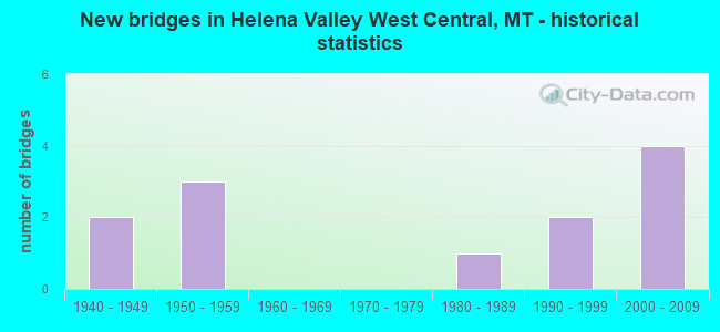
- New bridges - historical statistics
- 21940-1949
- 31950-1959
- 11980-1989
- 21990-1999
- 42000-2009
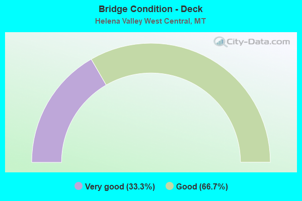
- Bridge Condition - Deck
- 33.3%Very good
- 66.7%Good
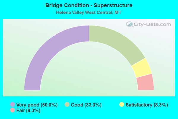
- Bridge Condition - Superstructure
- 50.0%Very good
- 33.3%Good
- 8.3%Satisfactory
- 8.3%Fair
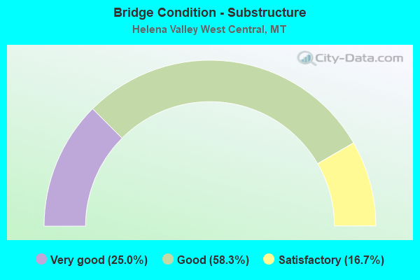
- Bridge Condition - Substructure
- 25.0%Very good
- 58.3%Good
- 16.7%Satisfactory
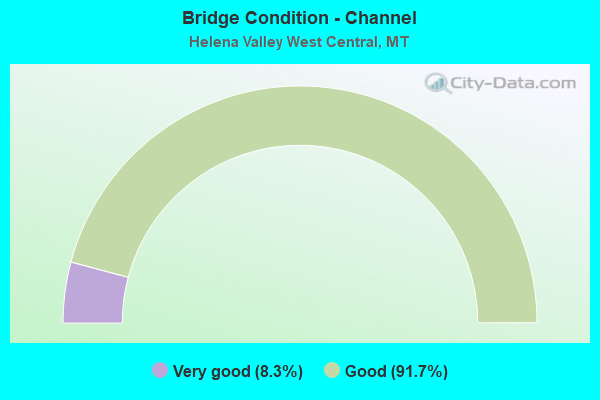
- Bridge Condition - Channel
- 8.3%Very good
- 91.7%Good
Find on map >> Show street view
Structure Number: L25602008+06001, Location: 6M NW HELENA (Lat: 46.649258, Lng: -112.121475), Route carried "on" structure: Spur County highway 25602, Year Built: 2001, Status: Open, Structure Length: 1.22m (4.00ft), Average Daily Traffic: 1,719 (year 2020), Truck Traffic: 3%, Average Future Daily Traffic: 1,805 (year 2040), Design Load: HS 20, Features Intersected: SEVEN MILE CREEK 034, Facility Carried by Structure: BIRDSEYE RD
Minimum Vertical Clearance: 30+ m (98+ ft), Kilometerpoint: 13.227, Lanes on structure: 2, Owner: County Highway Agency, Approaching Roadway Width: 8.4m (27.6ft), Material/Design: Prestressed concrete, Design/Construction: Tee Beam, Number Of Spans In Main Unit: 1, Length of Maximum Span: 11.9m (39.0ft), Curb-To-Curb Width: 8.4m (27.6ft), Out-to-Out Width: 9.1m (29.9ft)
Condition: Deck: Good, Superstructure: Very good, Substructure: Very good, Channel: Good, Operating Rating: 68.4 metric tons, Method Used To Determine Operating Rating: Load Factor (LF), Inventory Rating: 41.0 metric tons, Method Used To Determine Inventory Rating: Load Factor (LF), Structural Evaluation: Equal to present desirable criteria, Deck Geometry: Meets minimum limits, Waterway Adequacy: Equal to present desirable criteria, Approach Roadway Alignment: Equal to present minimum criteria, Designated Inspection Frequency: Every 24 months, Inspection Date: Febuary 2021, Deck Structure Type: Concrete Precast Panels, Wearing Surface/Protective System: Wearing Surface: Monolithic Concrete
Find on map >> Show street view
Structure Number: L25646001+04001, Location: 5M NW HELENA (Lat: 46.636792, Lng: -112.084467), Route carried "on" structure: Spur County highway 25646, Year Built: 1982, Status: Posted for load, Structure Length: 0.73m (2.40ft), Average Daily Traffic: 363 (year 2020), Average Future Daily Traffic: 381 (year 2040), Features Intersected: SEVEN MILE CREEK 149, Facility Carried by Structure: HEAD LN
Minimum Vertical Clearance: 30+ m (98+ ft), Kilometerpoint: 2.170, Lanes on structure: 2, Owner: County Highway Agency, Approaching Roadway Width: 7.3m (24.0ft), Material/Design: Wood or Timber, Design/Construction: Stringer/Multi-beam, Number Of Spans In Main Unit: 1, Length of Maximum Span: 7.3m (24.0ft), Curb-To-Curb Width: 7.5m (24.6ft), Out-to-Out Width: 7.9m (25.9ft)
Condition: Deck: Good, Superstructure: Fair, Substructure: Good, Channel: Good, Operating Rating: 7.3 metric tons, Method Used To Determine Operating Rating: Allowable Stress (AS), Inventory Rating: 3.6 metric tons, Method Used To Determine Inventory Rating: Allowable Stress (AS), Structural Evaluation: High priority of corrective action, Deck Geometry: Somewhat better than minimum adequacy, Waterway Adequacy: Better than present minimum criteria, Approach Roadway Alignment: Equal to present desirable criteria, Bridge Posting: Required (Relationship of Operating Rating to Maximum Legal Load: > 39.9% below), Designated Inspection Frequency: Every 24 months, Other Special Inspection Frequency: Every 11 months, Inspection Date: June 2020, Other Special Inspection Date: January 2022, Deck Structure Type: Wood or Timber, Wearing Surface/Protective System: Wearing Surface: Bituminous
Find on map >> Show street view
Structure Number: L25655000+06001, Location: 6M NW HELENA (Lat: 46.694300, Lng: -112.041847), Route carried "on" structure: Spur County highway 25655, Year Built: 1958, Year Reconstructed: 1996, Status: Posted for load, Structure Length: 0.85m (2.79ft), Average Daily Traffic: 974 (year 2020), Truck Traffic: 3%, Average Future Daily Traffic: 1,023 (year 2040), Design Load: H 15, Features Intersected: HELENA VALLEY CANAL 115, Facility Carried by Structure: APPLEGATE DR
Minimum Vertical Clearance: 30+ m (98+ ft), Kilometerpoint: 1.116, Lanes on structure: 2, Owner: County Highway Agency, Approaching Roadway Width: 7.9m (25.9ft), Skew: 3 degrees, Material/Design: Wood or Timber, Design/Construction: Stringer/Multi-beam, Number Of Spans In Main Unit: 1, Length of Maximum Span: 7.9m (25.9ft), Curb-To-Curb Width: 9.4m (30.8ft), Out-to-Out Width: 9.4m (30.8ft)
Condition: Deck: Very good, Superstructure: Satisfactory, Substructure: Good, Channel: Good, Operating Rating: 30.8 metric tons, Method Used To Determine Operating Rating: Allowable Stress (AS), Inventory Rating: 21.8 metric tons, Method Used To Determine Inventory Rating: Allowable Stress (AS), Structural Evaluation: Somewhat better than minimum adequacy, Deck Geometry: Equal to present minimum criteria, Waterway Adequacy: Equal to present desirable criteria, Approach Roadway Alignment: Equal to present desirable criteria, Bridge Posting: Required (Relationship of Operating Rating to Maximum Legal Load: 20.0 - 29.9% below), Designated Inspection Frequency: Every 24 months, Inspection Date: Febuary 2021, Deck Structure Type: Wood or Timber, Wearing Surface/Protective System: Wearing Surface: Bituminous
Find on map >> Show street view
Structure Number: L25655001+01001, Location: 5M NW HELENA (Lat: 46.686219, Lng: -112.042114), Route carried "on" structure: Spur County highway 25655, Year Built: 2005, Status: Open, Structure Length: 0.73m (2.40ft), Average Daily Traffic: 361 (year 2020), Truck Traffic: 3%, Average Future Daily Traffic: 379 (year 2040), Design Load: HS 20, Features Intersected: SILVER CREEK 144, Facility Carried by Structure: APPLEGATE DR
Minimum Vertical Clearance: 30+ m (98+ ft), Kilometerpoint: 2.014, Lanes on structure: 2, Owner: County Highway Agency, Approaching Roadway Width: 8.4m (27.6ft), Material/Design: Prestressed concrete, Design/Construction: Tee Beam, Number Of Spans In Main Unit: 1, Length of Maximum Span: 7.0m (23.0ft), Curb-To-Curb Width: 8.4m (27.6ft), Out-to-Out Width: 9.1m (29.9ft)
Condition: Deck: Very good, Superstructure: Very good, Substructure: Good, Channel: Good, Operating Rating: 32.7 metric tons, Method Used To Determine Operating Rating: Assigned rating based on Load Factor Design (LFD) reported in metric tons, Inventory Rating: 32.7 metric tons, Method Used To Determine Inventory Rating: Assigned rating based on Load Factor Design (LFD) reported in metric tons, Structural Evaluation: Better than present minimum criteria, Deck Geometry: Somewhat better than minimum adequacy, Waterway Adequacy: Equal to present desirable criteria, Approach Roadway Alignment: Equal to present desirable criteria, Designated Inspection Frequency: Every 24 months, Inspection Date: Febuary 2021, Deck Structure Type: Concrete Precast Panels, Wearing Surface/Protective System: Wearing Surface: Monolithic Concrete
Find on map >> Show street view
Structure Number: L25655002+03001, Location: 4M NW HELENA (Lat: 46.675083, Lng: -112.050942), Route carried "on" structure: Spur County highway 25655, Year Built: 1958, Status: Posted for load, Structure Length: 0.76m (2.49ft), Average Daily Traffic: 336 (year 2020), Truck Traffic: 3%, Average Future Daily Traffic: 353 (year 2040), Design Load: H 15, Features Intersected: HELENA VALLEY CANAL 114, Facility Carried by Structure: NORRIS RD
Minimum Vertical Clearance: 30+ m (98+ ft), Kilometerpoint: 3.875, Lanes on structure: 2, Owner: County Highway Agency, Approaching Roadway Width: 7.5m (24.6ft), Material/Design: Wood or Timber, Design/Construction: Stringer/Multi-beam, Number Of Spans In Main Unit: 1, Length of Maximum Span: 7.0m (23.0ft), Curb-To-Curb Width: 7.9m (25.9ft), Out-to-Out Width: 8.4m (27.6ft)
Condition: Deck: Good, Superstructure: Good, Substructure: Good, Channel: Good, Operating Rating: 23.6 metric tons, Method Used To Determine Operating Rating: Allowable Stress (AS), Inventory Rating: 15.4 metric tons, Method Used To Determine Inventory Rating: Allowable Stress (AS), Structural Evaluation: Meets minimum limits, Deck Geometry: Somewhat better than minimum adequacy, Waterway Adequacy: Equal to present desirable criteria, Approach Roadway Alignment: Equal to present desirable criteria, Bridge Posting: Required (Relationship of Operating Rating to Maximum Legal Load: > 39.9% below), Designated Inspection Frequency: Every 24 months, Inspection Date: Febuary 2021, Deck Structure Type: Wood or Timber, Wearing Surface/Protective System: Wearing Surface: Bituminous
Find on map >> Show street view
Structure Number: L25658000+05001, Location: 6M NW HELENA (Lat: 46.689692, Lng: -112.046289), Route carried "on" structure: Spur County highway 25658, Year Built: 1958, Status: Posted for load, Structure Length: 0.88m (2.89ft), Average Daily Traffic: 710 (year 2020), Truck Traffic: 3%, Average Future Daily Traffic: 746 (year 2040), Design Load: H 15, Features Intersected: HELENA VALLEY CANAL 116, Facility Carried by Structure: JOHN G MINE RD
Minimum Vertical Clearance: 30+ m (98+ ft), Kilometerpoint: 1.922, Lanes on structure: 2, Owner: County Highway Agency, Approaching Roadway Width: 7.5m (24.6ft), Skew: 3 degrees, Material/Design: Wood or Timber, Design/Construction: Stringer/Multi-beam, Number Of Spans In Main Unit: 1, Length of Maximum Span: 7.9m (25.9ft), Curb-To-Curb Width: 8.0m (26.2ft), Out-to-Out Width: 8.3m (27.2ft)
Condition: Deck: Good, Superstructure: Good, Substructure: Good, Channel: Good, Operating Rating: 19.1 metric tons, Method Used To Determine Operating Rating: Allowable Stress (AS), Inventory Rating: 12.7 metric tons, Method Used To Determine Inventory Rating: Allowable Stress (AS), Structural Evaluation: Meets minimum limits, Deck Geometry: Somewhat better than minimum adequacy, Waterway Adequacy: Equal to present desirable criteria, Approach Roadway Alignment: Equal to present desirable criteria, Bridge Posting: Required (Relationship of Operating Rating to Maximum Legal Load: > 39.9% below), Designated Inspection Frequency: Every 24 months, Inspection Date: Febuary 2021, Deck Structure Type: Wood or Timber, Wearing Surface/Protective System: Wearing Surface: Bituminous
Find on map >> Show street view
Structure Number: S00231001+00001, Location: 1M N HELENA (Lat: 46.631806, Lng: -112.047061), Route carried "on" structure: State highway 231, Year Built: 1992, Status: Open, Structure Length: 2.41m (7.91ft), Average Daily Traffic: 4,837 (year 2020), Average Future Daily Traffic: 5,079 (year 2040), Design Load: HS 20, Features Intersected: TEN MILE CREEK, Facility Carried by Structure: GREEN MEADOW DR
Minimum Vertical Clearance: 30+ m (98+ ft), Kilometerpoint: 1.712, Lanes on structure: 2, Owner: State Highway Agency, Approaching Roadway Width: 12.4m (40.7ft), Skew: 4 degrees, Material/Design: Concrete continuous, Design/Construction: Slab, Number Of Spans In Main Unit: 3, Length of Maximum Span: 9.1m (29.9ft), Curb-To-Curb Width: 12.6m (41.3ft), Out-to-Out Width: 13.2m (43.3ft)
Condition: Deck: Good, Superstructure: Very good, Substructure: Good, Channel: Good, Operating Rating: 73.2 metric tons, Method Used To Determine Operating Rating: Load Factor (LF), Inventory Rating: 43.9 metric tons, Method Used To Determine Inventory Rating: Load Factor (LF), Structural Evaluation: Better than present minimum criteria, Deck Geometry: Equal to present minimum criteria, Waterway Adequacy: Equal to present desirable criteria, Approach Roadway Alignment: Equal to present desirable criteria, Designated Inspection Frequency: Every 24 months, Inspection Date: October 2020, Deck Structure Type: Concrete Cast-file-Place, Wearing Surface/Protective System: Wearing Surface: Monolithic Concrete, Deck Protection: Epoxy Coated Reinforcing
Find on map >> Show street view
Structure Number: S00231002+01001, Location: 2M N HELENA (Lat: 46.648406, Lng: -112.047283), Route carried "on" structure: State highway 231, Year Built: 1992, Status: Open, Structure Length: 1.89m (6.20ft), Average Daily Traffic: 4,348 (year 2020), Average Future Daily Traffic: 4,565 (year 2040), Design Load: HS 20, Features Intersected: HELENA VALLEY CANAL, Facility Carried by Structure: GREEN MEADOW DR
Minimum Vertical Clearance: 30+ m (98+ ft), Kilometerpoint: 3.558, Lanes on structure: 2, Owner: State Highway Agency, Approaching Roadway Width: 12.4m (40.7ft), Skew: 4 degrees, Material/Design: Concrete continuous, Design/Construction: Slab, Number Of Spans In Main Unit: 3, Length of Maximum Span: 7.0m (23.0ft), Curb-To-Curb Width: 12.4m (40.7ft), Out-to-Out Width: 12.9m (42.3ft)
Condition: Deck: Very good, Superstructure: Very good, Substructure: Good, Channel: Good, Operating Rating: 49.9 metric tons, Method Used To Determine Operating Rating: Load Factor (LF), Inventory Rating: 29.9 metric tons, Method Used To Determine Inventory Rating: Load Factor (LF), Structural Evaluation: Better than present minimum criteria, Deck Geometry: Equal to present minimum criteria, Waterway Adequacy: Equal to present desirable criteria, Approach Roadway Alignment: Equal to present desirable criteria, Designated Inspection Frequency: Every 24 months, Inspection Date: October 2020, Deck Structure Type: Concrete Cast-file-Place, Wearing Surface/Protective System: Wearing Surface: Monolithic Concrete, Deck Protection: Epoxy Coated Reinforcing
Find on map >> Show street view
Structure Number: S00231003+06001, Location: 4M N HELENA (Lat: 46.674156, Lng: -112.051322), Route carried "on" structure: State highway 231, Year Built: 2000, Status: Open, Structure Length: 1.19m (3.90ft), Average Daily Traffic: 3,509 (year 2020), Truck Traffic: 1%, Average Future Daily Traffic: 3,720 (year 2040), Design Load: HS 20, Features Intersected: HELENA VALLEY CANAL, Facility Carried by Structure: GREEN MEADOW DR
Minimum Vertical Clearance: 30+ m (98+ ft), Kilometerpoint: 6.436, Lanes on structure: 2, Owner: State Highway Agency, Approaching Roadway Width: 8.3m (27.2ft), Skew: 4 degrees, Material/Design: Prestressed concrete, Design/Construction: Tee Beam, Number Of Spans In Main Unit: 1, Length of Maximum Span: 11.9m (39.0ft), Curb-To-Curb Width: 8.5m (27.9ft), Out-to-Out Width: 9.1m (29.9ft)
Condition: Deck: Good, Superstructure: Very good, Substructure: Very good, Channel: Good, Operating Rating: 32.7 metric tons, Method Used To Determine Operating Rating: Assigned rating based on Load Factor Design (LFD) reported in metric tons, Inventory Rating: 32.7 metric tons, Method Used To Determine Inventory Rating: Assigned rating based on Load Factor Design (LFD) reported in metric tons, Structural Evaluation: Equal to present desirable criteria, Deck Geometry: Meets minimum limits, Waterway Adequacy: Equal to present desirable criteria, Approach Roadway Alignment: Equal to present desirable criteria, Designated Inspection Frequency: Every 24 months, Inspection Date: October 2020, Deck Structure Type: Concrete Precast Panels, Wearing Surface/Protective System: Wearing Surface: Monolithic Concrete
Find on map >> Show street view
Structure Number: S00231005+05001, Location: 6M N HELENA (Lat: 46.695456, Lng: -112.060975), Route carried "on" structure: State highway 231, Year Built: 2000, Status: Open, Structure Length: 1.22m (4.00ft), Average Daily Traffic: 1,913 (year 2020), Truck Traffic: 3%, Average Future Daily Traffic: 2,028 (year 2040), Design Load: HS 20, Features Intersected: SILVER CREEK, Facility Carried by Structure: GREEN MEADOW DR
Minimum Vertical Clearance: 30+ m (98+ ft), Kilometerpoint: 8.968, Lanes on structure: 2, Owner: State Highway Agency, Approaching Roadway Width: 8.4m (27.6ft), Skew: 2 degrees, Material/Design: Prestressed concrete, Design/Construction: Tee Beam, Number Of Spans In Main Unit: 1, Length of Maximum Span: 12.2m (40.0ft), Curb-To-Curb Width: 8.4m (27.6ft), Out-to-Out Width: 9.1m (29.9ft)
Condition: Deck: Very good, Superstructure: Very good, Substructure: Very good, Channel: Very good, Operating Rating: 65.7 metric tons, Method Used To Determine Operating Rating: Load Factor (LF), Inventory Rating: 39.4 metric tons, Method Used To Determine Inventory Rating: Load Factor (LF), Structural Evaluation: Equal to present desirable criteria, Deck Geometry: Meets minimum limits, Waterway Adequacy: Better than present minimum criteria, Approach Roadway Alignment: Equal to present desirable criteria, Designated Inspection Frequency: Every 24 months, Inspection Date: October 2020, Deck Structure Type: Concrete Precast Panels
Find on map >> Show street view
Structure Number: S00279001+00661, Location: 6M N HELENA (Lat: 46.704397, Lng: -112.034906), Route carried "on" structure: Spur State highway 279, Year Built: 1942, Status: Open, Structure Length: 0.64m (2.10ft), Average Daily Traffic: 4,575 (year 2020), Truck Traffic: 2%, Average Future Daily Traffic: 4,987 (year 2040), Features Intersected: HELENA VALLEY CANAL, Facility Carried by Structure: LINCOLN RD W
Minimum Vertical Clearance: 30+ m (98+ ft), Kilometerpoint: 1.765, Lanes on structure: 2, Owner: State Highway Agency, Approaching Roadway Width: 8.5m (27.9ft), Material/Design: Wood or Timber, Design/Construction: Stringer/Multi-beam, Number Of Spans In Main Unit: 1, Length of Maximum Span: 5.8m (19.0ft), Curb or Sidewalk Widths: Left: 0.3m (1.0ft), Right: 0.3m (1.0ft), Curb-To-Curb Width: 8.6m (28.2ft), Out-to-Out Width: 9.1m (29.9ft)
Condition: Deck: Good, Superstructure: Good, Substructure: Satisfactory, Channel: Good, Operating Rating: 44.5 metric tons, Method Used To Determine Operating Rating: Allowable Stress (AS), Inventory Rating: 30.8 metric tons, Method Used To Determine Inventory Rating: Allowable Stress (AS), Structural Evaluation: Equal to present minimum criteria, Deck Geometry: Meets minimum limits, Waterway Adequacy: Equal to present desirable criteria, Approach Roadway Alignment: Equal to present desirable criteria, Designated Inspection Frequency: Every 24 months, Inspection Date: September 2020, Deck Structure Type: Wood or Timber, Wearing Surface/Protective System: Wearing Surface: Bituminous
Find on map >> Show street view
Structure Number: S00279001+00851, Location: 6M N HELENA (Lat: 46.704364, Lng: -112.036042), Route carried "on" structure: State highway 279, Year Built: 1942, Status: Open, Structure Length: 0.62m (2.03ft), Average Daily Traffic: 4,575 (year 2020), Truck Traffic: 2%, Average Future Daily Traffic: 4,987 (year 2040), Features Intersected: DRAINAGE, Facility Carried by Structure: LINCOLN RD W
Minimum Vertical Clearance: 30+ m (98+ ft), Kilometerpoint: 1.849, Lanes on structure: 2, Owner: State Highway Agency, Approaching Roadway Width: 7.4m (24.3ft), Skew: 2 degrees, Material/Design: Wood or Timber, Design/Construction: Stringer/Multi-beam, Number Of Spans In Main Unit: 1, Length of Maximum Span: 5.8m (19.0ft), Curb or Sidewalk Widths: Left: 0.2m (0.7ft), Right: 0.2m (0.7ft), Curb-To-Curb Width: 7.4m (24.3ft), Out-to-Out Width: 8.0m (26.2ft)
Condition: Deck: Good, Superstructure: Good, Substructure: Satisfactory, Channel: Good, Operating Rating: 48.4 metric tons, Method Used To Determine Operating Rating: Allowable Stress (AS), Inventory Rating: 35.7 metric tons, Method Used To Determine Inventory Rating: Allowable Stress (AS), Structural Evaluation: Equal to present minimum criteria, Deck Geometry: High priority of replacement, Waterway Adequacy: Equal to present desirable criteria, Approach Roadway Alignment: Equal to present desirable criteria, Length Of Structure Improvement: 1.20m (3.94ft), Designated Inspection Frequency: Every 24 months, Inspection Date: September 2020, Bridge Improvement Cost: $31,000, Roadway Improvement Cost: $16,000, Total Project Cost: $47,000, Deck Structure Type: Wood or Timber, Wearing Surface/Protective System: Wearing Surface: Bituminous