Bridge Statistics for Helena, Montana (MT)
Condition, Traffic, Stress, Structural Evaluation, Project Costs
- National Bridge Inventory (NBI) Statistics
- 29Number of bridges
- 354ft / 108mTotal length
- $6,132,000Total costs
- 291,817Total average daily traffic
- 6,879Total average daily truck traffic
- National Bridge Inventory (NBI) Registered Bridges for Helena
- No street view available for this location
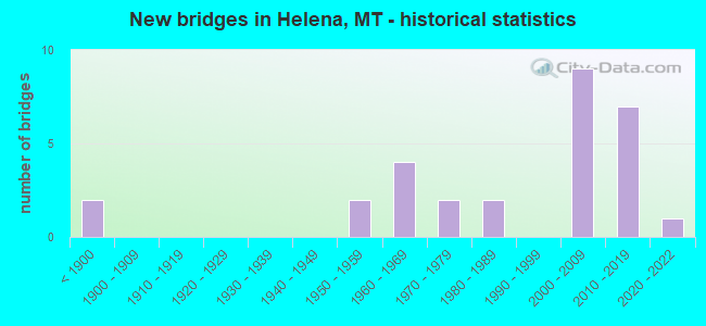
- New bridges - historical statistics
- 2Before 1900
- 21950-1959
- 41960-1969
- 21970-1979
- 21980-1989
- 92000-2009
- 72010-2019
- 12020-2022
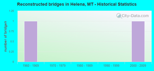
- Reconstructed bridges - Historical Statistics
- 11960-1969
- 01970-1979
- 01980-1989
- 01990-1999
- 12000-2009
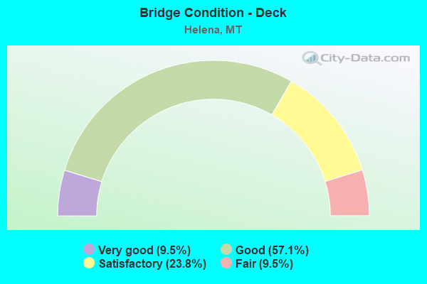
- Bridge Condition - Deck
- 9.5%Very good
- 57.1%Good
- 23.8%Satisfactory
- 9.5%Fair
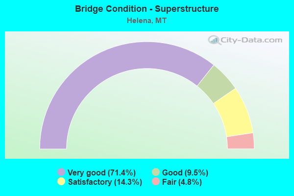
- Bridge Condition - Superstructure
- 71.4%Very good
- 9.5%Good
- 14.3%Satisfactory
- 4.8%Fair
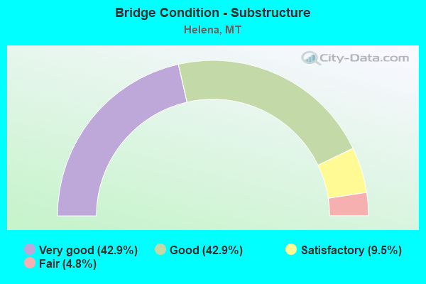
- Bridge Condition - Substructure
- 42.9%Very good
- 42.9%Good
- 9.5%Satisfactory
- 4.8%Fair
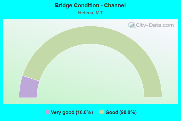
- Bridge Condition - Channel
- 10.0%Very good
- 90.0%Good
Find on map >> Show street view
Structure Number: 1178, Location: HELENA (Lat: 46.598561, Lng: -112.003147), Route carried "on" structure: Interstate 15, Year Built: 2016, Status: Open, Structure Length: 24.11m (79.10ft), Average Daily Traffic: 21,738 (year 2020), Truck Traffic: 3%, Average Future Daily Traffic: 23,694 (year 2040), Design Load: HL 93, Features Intersected: SEP BOULDER AVE-RR
Minimum Vertical Clearance: 30+ m (98+ ft), Kilometerpoint: 309.477, Lanes on structure: 3, Lanes under structure: 2, Base Highway Network: Yes, Owner: State Highway Agency, Approaching Roadway Width: 19.7m (64.6ft), Skew: 3 degrees, Material/Design: Steel continuous, Design/Construction: Stringer/Multi-beam, Number Of Spans In Main Unit: 4, Length of Maximum Span: 64.6m (211.9ft), Curb-To-Curb Width: 18.7m (61.4ft), Out-to-Out Width: 19.5m (64.0ft)
Condition: Deck: Good, Superstructure: Very good, Substructure: Very good, Operating Rating: 38.1 metric tons, Method Used To Determine Operating Rating: Load and Resistance Factor (LRFR), Inventory Rating: 29.0 metric tons, Method Used To Determine Inventory Rating: Load and Resistance Factor (LRFR), Structural Evaluation: Better than present minimum criteria, Deck Geometry: Superior to present desirable criteria, Underclear: Equal to present minimum criteria, Approach Roadway Alignment: Equal to present desirable criteria, Length Of Structure Improvement: 24.69m (81.00ft), Designated Inspection Frequency: Every 24 months, Inspection Date: October 2020, Bridge Improvement Cost: $1,531,000, Roadway Improvement Cost: $766,000, Total Project Cost: $2,297,000, Deck Structure Type: Concrete Cast-file-Place, Wearing Surface/Protective System: Wearing Surface: Monolithic Concrete, Deck Protection: Epoxy Coated Reinforcing
Find on map >> Show street view
Structure Number: 1179, Location: HELENA (Lat: 46.598617, Lng: -112.003439), Route carried "on" structure: Interstate 15, Year Built: 2017, Status: Open, Structure Length: 23.90m (78.41ft), Average Daily Traffic: 21,738 (year 2020), Truck Traffic: 3%, Average Future Daily Traffic: 23,694 (year 2040), Design Load: HL 93, Features Intersected: SEP BOULDER AVE-RR
Minimum Vertical Clearance: 30+ m (98+ ft), Kilometerpoint: 309.231, Lanes on structure: 3, Lanes under structure: 2, Base Highway Network: Yes, Owner: State Highway Agency, Approaching Roadway Width: 17.7m (58.1ft), Skew: 3 degrees, Material/Design: Steel continuous, Design/Construction: Stringer/Multi-beam, Number Of Spans In Main Unit: 4, Length of Maximum Span: 64.6m (211.9ft), Curb-To-Curb Width: 18.7m (61.4ft), Out-to-Out Width: 19.5m (64.0ft)
Condition: Deck: Good, Superstructure: Very good, Substructure: Very good, Operating Rating: 47.2 metric tons, Method Used To Determine Operating Rating: Load and Resistance Factor (LRFR), Inventory Rating: 36.3 metric tons, Method Used To Determine Inventory Rating: Load and Resistance Factor (LRFR), Structural Evaluation: Equal to present desirable criteria, Deck Geometry: Superior to present desirable criteria, Underclear: Meets minimum limits, Approach Roadway Alignment: Better than present minimum criteria, Length Of Structure Improvement: 24.29m (79.69ft), Designated Inspection Frequency: Every 24 months, Inspection Date: October 2021, Bridge Improvement Cost: $1,508,000, Roadway Improvement Cost: $754,000, Total Project Cost: $2,262,000, Deck Structure Type: Concrete Cast-file-Place, Wearing Surface/Protective System: Deck Protection: Epoxy Coated Reinforcing
Find on map >> Show street view
Structure Number: 202104939, Location: 2M NW HELENA (Lat: 46.645658, Lng: -112.046439), Route carried "on" structure: City street 25058, Year Built: 2021, Status: Open, Structure Length: 1.48m (4.86ft), Average Daily Traffic: 910 (year 2020), Average Future Daily Traffic: 956 (year 2040), Design Load: HL 93, Features Intersected: HELENA VALLEY CANAL 082, Facility Carried by Structure: MILL ROAD
Minimum Vertical Clearance: 30+ m (98+ ft), Kilometerpoint: 0.037, Lanes on structure: 2, Owner: County Highway Agency, Approaching Roadway Width: 8.5m (27.9ft), Material/Design: Concrete, Design/Construction: Tee Beam, Number Of Spans In Main Unit: 1, Length of Maximum Span: 14.0m (45.9ft), Curb-To-Curb Width: 8.5m (27.9ft), Out-to-Out Width: 9.2m (30.2ft)
Condition: Deck: Very good, Superstructure: Very good, Substructure: Very good, Channel: Good, Operating Rating: 55.3 metric tons, Method Used To Determine Operating Rating: Load and Resistance Factor (LRFR), Inventory Rating: 38.1 metric tons, Method Used To Determine Inventory Rating: Load and Resistance Factor (LRFR), Structural Evaluation: Equal to present desirable criteria, Deck Geometry: Somewhat better than minimum adequacy, Waterway Adequacy: Equal to present desirable criteria, Approach Roadway Alignment: Equal to present desirable criteria, Designated Inspection Frequency: Every 24 months, Inspection Date: November 2021, Deck Structure Type: Concrete Precast Panels, Wearing Surface/Protective System: Wearing Surface: Monolithic Concrete
Find on map >> Show street view
Structure Number: L25608000+00001, Location: 1M S HELENA (Lat: 46.574622, Lng: -111.974661), Route carried "on" structure: City street 5827, Year Built: 2007, Status: Open, Structure Length: 5.68m (18.64ft), Average Daily Traffic: 4,729 (year 2020), Truck Traffic: 3%, Average Future Daily Traffic: 4,965 (year 2040), Design Load: HS 25 or greater, Features Intersected: S HELENA INT I 15 156, Facility Carried by Structure: SADDLE DRIVE
Minimum Vertical Clearance: 30+ m (98+ ft), Kilometerpoint: 2.477, Lanes on structure: 2, Lanes under structure: 4, Owner: State Highway Agency, Approaching Roadway Width: 22.4m (73.5ft), Skew: 20 degrees, Material/Design: Prestressed concrete, Design/Construction: Stringer/Multi-beam, Number Of Spans In Main Unit: 2, Length of Maximum Span: 28.0m (91.9ft), Curb or Sidewalk Widths: Left: 1.4m (4.6ft), Right: 1.4m (4.6ft), Curb-To-Curb Width: 22.4m (73.5ft), Out-to-Out Width: 25.6m (84.0ft)
Condition: Deck: Good, Superstructure: Very good, Substructure: Good, Operating Rating: 68.0 metric tons, Method Used To Determine Operating Rating: Assigned rating based on Load Factor Design (LFD) reported in metric tons, Inventory Rating: 40.8 metric tons, Method Used To Determine Inventory Rating: Assigned rating based on Load Factor Design (LFD) reported in metric tons, Structural Evaluation: Better than present minimum criteria, Deck Geometry: Superior to present desirable criteria, Underclear: Better than present minimum criteria, Approach Roadway Alignment: Equal to present desirable criteria, Designated Inspection Frequency: Every 48 months, Inspection Date: October 2019, Deck Structure Type: Concrete Cast-file-Place, Wearing Surface/Protective System: Wearing Surface: Monolithic Concrete, Deck Protection: Epoxy Coated Reinforcing
Find on map >> Show street view
Structure Number: M25058000+00101, Location: HELENA-REEDERS ALLEY (Lat: 46.585703, Lng: -112.044728), Route carried "on" structure: City street 2738, Year Built: 1881, Year Reconstructed: 1974, Status: Posted for load, Structure Length: 2.84m (9.32ft), Average Daily Traffic: 100 (year 2022), Truck Traffic: 3%, Average Future Daily Traffic: 100 (year 2037), Design Load: H 10, Features Intersected: REEDERS ALLEY 001, Facility Carried by Structure: S HOWIE ST
Minimum Vertical Clearance: 30+ m (98+ ft), Kilometerpoint: 0.000, Lanes on structure: 2, Lanes under structure: 1, Owner: County Highway Agency, Approaching Roadway Width: 4.3m (14.1ft), Material/Design: Wood or Timber, Design/Construction: Stringer/Multi-beam, Number Of Spans In Main Unit: 4, Length of Maximum Span: 7.4m (24.3ft), Curb or Sidewalk Widths: Left: 0.1m (0.3ft), Right: 0.1m (0.3ft), Curb-To-Curb Width: 6.1m (20.0ft), Out-to-Out Width: 6.7m (22.0ft)
Condition: Deck: Fair, Superstructure: Fair, Substructure: Good, Operating Rating: 18.1 metric tons, Method Used To Determine Operating Rating: Allowable Stress (AS), Inventory Rating: 13.6 metric tons, Method Used To Determine Inventory Rating: Allowable Stress (AS), Structural Evaluation: Meets minimum limits, Deck Geometry: High priority of replacement, Underclear: High priority of replacement, Approach Roadway Alignment: Equal to present minimum criteria, Bridge Posting: Required (Relationship of Operating Rating to Maximum Legal Load: > 39.9% below), Length Of Structure Improvement: 3.80m (12.47ft), Designated Inspection Frequency: Every 24 months, Inspection Date: March 2020, Bridge Improvement Cost: $122,000, Roadway Improvement Cost: $61,000, Total Project Cost: $183,000, Deck Structure Type: Wood or Timber, Wearing Surface/Protective System: Wearing Surface: Wood or Timber
Find on map >> Show street view
Structure Number: M25058000+00201, Location: N OF HELENA AIRPORT (Lat: 46.612178, Lng: -111.967892), Route carried "on" structure: City street 25058, Year Built: 1958, Status: Posted for load, Structure Length: 1.22m (4.00ft), Average Daily Traffic: 100 (year 2022), Truck Traffic: 3%, Average Future Daily Traffic: 100 (year 2037), Design Load: H 15, Features Intersected: HELENA VALLEY CANAL 085, Facility Carried by Structure: COUNTY ROAD 290
Minimum Vertical Clearance: 30+ m (98+ ft), Kilometerpoint: 0.117, Lanes on structure: 2, Owner: County Highway Agency, Approaching Roadway Width: 6.1m (20.0ft), Skew: 1 degrees, Material/Design: Wood or Timber, Design/Construction: Stringer/Multi-beam, Number Of Spans In Main Unit: 2, Length of Maximum Span: 5.8m (19.0ft), Curb-To-Curb Width: 7.5m (24.6ft), Out-to-Out Width: 7.7m (25.3ft)
Condition: Deck: Good, Superstructure: Good, Substructure: Good, Channel: Good, Operating Rating: 23.6 metric tons, Method Used To Determine Operating Rating: Allowable Stress (AS), Inventory Rating: 17.2 metric tons, Method Used To Determine Inventory Rating: Allowable Stress (AS), Structural Evaluation: Somewhat better than minimum adequacy, Deck Geometry: Equal to present minimum criteria, Waterway Adequacy: Equal to present desirable criteria, Approach Roadway Alignment: Equal to present minimum criteria, Bridge Posting: Required (Relationship of Operating Rating to Maximum Legal Load: 30.0 - 39.9% below), Designated Inspection Frequency: Every 24 months, Inspection Date: Febuary 2021, Deck Structure Type: Wood or Timber, Wearing Surface/Protective System: Wearing Surface: Wood or Timber
Find on map >> Show street view
Structure Number: M25058000+00301, Location: HELENA-WOODBRIDGE DRIVE (Lat: 46.577503, Lng: -112.022486), Route carried "on" structure: City street 25058, Year Built: 1975, Status: Posted for load, Structure Length: 2.77m (9.09ft), Average Daily Traffic: 100 (year 2022), Truck Traffic: 3%, Average Future Daily Traffic: 100 (year 2037), Design Load: HS 20, Features Intersected: DRAINAGE 002, Facility Carried by Structure: WOODBRIDGE DRIVE
Minimum Vertical Clearance: 30+ m (98+ ft), Kilometerpoint: 0.056, Lanes on structure: 2, Owner: County Highway Agency, Approaching Roadway Width: 7.7m (25.3ft), Skew: 1 degrees, Material/Design: Wood or Timber, Design/Construction: Arch - Deck, Number Of Spans In Main Unit: 1, Number Of Approach Spans: 2, Length of Maximum Span: 18.3m (60.0ft), Curb or Sidewalk Widths: Left: 2.2m (7.2ft), Right: 1.6m (5.2ft), Curb-To-Curb Width: 8.0m (26.2ft), Out-to-Out Width: 11.7m (38.4ft)
Condition: Deck: Satisfactory, Superstructure: Satisfactory, Substructure: Fair, Channel: Good, Operating Rating: 23.6 metric tons, Method Used To Determine Operating Rating: Load and Resistance Factor (LRFR), Inventory Rating: 18.1 metric tons, Method Used To Determine Inventory Rating: Load and Resistance Factor (LRFR), Structural Evaluation: Somewhat better than minimum adequacy, Deck Geometry: Equal to present minimum criteria, Waterway Adequacy: Equal to present desirable criteria, Approach Roadway Alignment: Equal to present minimum criteria, Bridge Posting: Required (Relationship of Operating Rating to Maximum Legal Load: 10.0 - 19.9% below), Designated Inspection Frequency: Every 24 months, Inspection Date: December 2020, Deck Structure Type: Corrugated Steel, Wearing Surface/Protective System: Wearing Surface: Monolithic Concrete
Find on map >> Show street view
Structure Number: M25058000+00401, Location: 2M N HELENA (Lat: 46.632331, Lng: -112.031836), Route carried "on" structure: City street 25058, Year Built: 2000, Status: Open, Structure Length: 1.44m (4.72ft), Average Daily Traffic: 1,763 (year 2020), Truck Traffic: 1%, Average Future Daily Traffic: 2,063 (year 2040), Features Intersected: HELENA VALLEY CANAL 086, Facility Carried by Structure: MCHUGH LN
Minimum Vertical Clearance: 30+ m (98+ ft), Kilometerpoint: 2.576, Lanes on structure: 2, Owner: County Highway Agency, Approaching Roadway Width: 8.3m (27.2ft), Skew: 5 degrees, Material/Design: Prestressed concrete, Design/Construction: Tee Beam, Number Of Spans In Main Unit: 1, Length of Maximum Span: 14.4m (47.2ft), Curb-To-Curb Width: 8.4m (27.6ft), Out-to-Out Width: 9.1m (29.9ft)
Condition: Deck: Very good, Superstructure: Very good, Substructure: Good, Channel: Good, Operating Rating: 54.4 metric tons, Method Used To Determine Operating Rating: Field evaluation and documented engineering judgment, Inventory Rating: 32.7 metric tons, Method Used To Determine Inventory Rating: Field evaluation and documented engineering judgment, Structural Evaluation: Better than present minimum criteria, Deck Geometry: Meets minimum limits, Waterway Adequacy: Equal to present desirable criteria, Approach Roadway Alignment: Equal to present desirable criteria, Designated Inspection Frequency: Every 24 months, Inspection Date: Febuary 2021, Deck Structure Type: Concrete Precast Panels, Wearing Surface/Protective System: Wearing Surface: Bituminous
Find on map >> Show street view
Structure Number: M25058000+00501, Location: 2M N HELENA (Lat: 46.634250, Lng: -112.031911), Route carried "on" structure: City street 25058, Year Built: 1989, Status: Open, Structure Length: 1.19m (3.90ft), Average Daily Traffic: 1,763 (year 2020), Truck Traffic: 1%, Average Future Daily Traffic: 2,063 (year 2040), Design Load: HS 20, Features Intersected: TEN MILE CREEK 087, Facility Carried by Structure: MCHUGH LN
Minimum Vertical Clearance: 30+ m (98+ ft), Kilometerpoint: 2.789, Lanes on structure: 2, Owner: County Highway Agency, Approaching Roadway Width: 12.0m (39.4ft), Material/Design: Concrete continuous, Design/Construction: Slab, Number Of Spans In Main Unit: 3, Length of Maximum Span: 8.2m (26.9ft), Curb-To-Curb Width: 12.0m (39.4ft), Out-to-Out Width: 12.9m (42.3ft)
Condition: Deck: Good, Superstructure: Very good, Substructure: Good, Channel: Good, Operating Rating: 56.3 metric tons, Method Used To Determine Operating Rating: Load Factor (LF), Inventory Rating: 33.7 metric tons, Method Used To Determine Inventory Rating: Load Factor (LF), Structural Evaluation: Better than present minimum criteria, Deck Geometry: Equal to present minimum criteria, Waterway Adequacy: Equal to present desirable criteria, Approach Roadway Alignment: Equal to present desirable criteria, Designated Inspection Frequency: Every 24 months, Inspection Date: March 2021, Deck Structure Type: Concrete Cast-file-Place, Wearing Surface/Protective System: Wearing Surface: Bituminous, Deck Protection: Epoxy Coated Reinforcing
Find on map >> Show street view
Structure Number: M25058000+00701, Location: 3M W HELENA (Lat: 46.614261, Lng: -112.076650), Route carried "on" structure: City street 25058, Year Built: 2000, Status: Open, Structure Length: 2.27m (7.45ft), Average Daily Traffic: 2,735 (year 2020), Truck Traffic: 3%, Average Future Daily Traffic: 2,872 (year 2040), Design Load: HS 20, Features Intersected: TEN MILE CREEK 113, Facility Carried by Structure: COUNTRY CLUB AVE
Minimum Vertical Clearance: 30+ m (98+ ft), Kilometerpoint: 1.725, Lanes on structure: 2, Owner: County Highway Agency, Approaching Roadway Width: 9.1m (29.9ft), Skew: 2 degrees, Material/Design: Prestressed concrete, Design/Construction: Tee Beam, Number Of Spans In Main Unit: 1, Length of Maximum Span: 22.7m (74.5ft), Curb-To-Curb Width: 9.1m (29.9ft), Out-to-Out Width: 9.8m (32.2ft)
Condition: Deck: Good, Superstructure: Very good, Substructure: Good, Channel: Good, Operating Rating: 32.7 metric tons, Method Used To Determine Operating Rating: Assigned rating based on Load Factor Design (LFD) reported in metric tons, Inventory Rating: 32.7 metric tons, Method Used To Determine Inventory Rating: Assigned rating based on Load Factor Design (LFD) reported in metric tons, Structural Evaluation: Better than present minimum criteria, Deck Geometry: Meets minimum limits, Waterway Adequacy: Equal to present desirable criteria, Approach Roadway Alignment: Equal to present desirable criteria, Designated Inspection Frequency: Every 24 months, Inspection Date: March 2021, Deck Structure Type: Concrete Precast Panels, Wearing Surface/Protective System: Wearing Surface: Monolithic Concrete
Find on map >> Show street view
Structure Number: M25058000+00801, Location: HELENA-VALLEY FORGE RD (Lat: 46.639175, Lng: -112.019853), Route carried "on" structure: County highway 25058, Year Built: 1988, Status: Open, Structure Length: 1.42m (4.66ft), Average Daily Traffic: 100 (year 2022), Truck Traffic: 3%, Average Future Daily Traffic: 100 (year 2037), Design Load: HS 20, Features Intersected: TEN MILE CREEK 126, Facility Carried by Structure: VALLEY FORGE RD
Minimum Vertical Clearance: 30+ m (98+ ft), Kilometerpoint: 0.116, Lanes on structure: 2, Owner: County Highway Agency, Approaching Roadway Width: 11.9m (39.0ft), Skew: 2 degrees, Material/Design: Prestressed concrete, Design/Construction: Stringer/Multi-beam, Number Of Spans In Main Unit: 1, Length of Maximum Span: 13.7m (44.9ft), Curb-To-Curb Width: 10.5m (34.4ft), Out-to-Out Width: 11.0m (36.1ft)
Condition: Deck: Good, Superstructure: Very good, Substructure: Very good, Channel: Good, Operating Rating: 32.7 metric tons, Method Used To Determine Operating Rating: Assigned rating based on Load Factor Design (LFD) reported in metric tons, Inventory Rating: 32.7 metric tons, Method Used To Determine Inventory Rating: Assigned rating based on Load Factor Design (LFD) reported in metric tons, Structural Evaluation: Equal to present desirable criteria, Deck Geometry: Superior to present desirable criteria, Waterway Adequacy: Equal to present desirable criteria, Approach Roadway Alignment: Equal to present desirable criteria, Designated Inspection Frequency: Every 24 months, Inspection Date: March 2021, Deck Structure Type: Concrete Cast-file-Place, Wearing Surface/Protective System: Wearing Surface: Bituminous
Find on map >> Show street view
Structure Number: P00008043+03061, Location: HELENA-LYNDALE AVE (Lat: 46.598086, Lng: -112.036125), Route carried "on" structure: US 12, Year Built: 2003, Status: Open, Structure Length: 0.61m (2.00ft), Average Daily Traffic: 17,821 (year 2020), Truck Traffic: 2%, Average Future Daily Traffic: 18,712 (year 2040), Design Load: HS 20, Features Intersected: GREAT NORTHERN AREA
Minimum Vertical Clearance: 30+ m (98+ ft), Kilometerpoint: 69.207, Lanes on structure: 4, Base Highway Network: Yes, Owner: State Highway Agency, Approaching Roadway Width: 29.9m (98.1ft), Skew: 22 degrees, Material/Design: Concrete, Design/Construction: Arch - Deck, Number Of Spans In Main Unit: 1, Length of Maximum Span: 6.1m (20.0ft), Curb or Sidewalk Widths: Left: 2.3m (7.5ft), Right: 2.3m (7.5ft), Curb-To-Curb Width: 29.9m (98.1ft), Out-to-Out Width: 29.9m (98.1ft)
Condition: Deck: Good, Superstructure: Good, Substructure: Good, Operating Rating: 32.7 metric tons, Method Used To Determine Operating Rating: Load Factor (LF), Inventory Rating: 32.7 metric tons, Method Used To Determine Inventory Rating: Load Factor (LF), Structural Evaluation: Better than present minimum criteria, Deck Geometry: Superior to present desirable criteria, Approach Roadway Alignment: Equal to present desirable criteria, Designated Inspection Frequency: Every 24 months, Inspection Date: October 2020
Find on map >> Show street view
Structure Number: P00008046+12211, Location: HELENA-PROSPECT AVE (Lat: 46.591156, Lng: -111.998497), Route carried "on" structure: US 12, Year Built: 1961, Status: Open, Structure Length: 7.94m (26.05ft), Average Daily Traffic: 20,402 (year 2020), Truck Traffic: 2%, Average Future Daily Traffic: 21,422 (year 2040), Design Load: HS 20, Features Intersected: INT CAPITOL-I 15
Minimum Vertical Clearance: 30+ m (98+ ft), Kilometerpoint: 73.013, Lanes on structure: 2, Lanes under structure: 4, Base Highway Network: Yes, Owner: State Highway Agency, Approaching Roadway Width: 9.9m (32.5ft), Skew: 3 degrees, Material/Design: Steel, Design/Construction: Stringer/Multi-beam, Number Of Spans In Main Unit: 4, Length of Maximum Span: 23.2m (76.1ft), Curb or Sidewalk Widths: Left: 0.1m (0.3ft), Right: 0.6m (2.0ft), Curb-To-Curb Width: 8.5m (27.9ft), Out-to-Out Width: 9.7m (31.8ft)
Condition: Deck: Satisfactory, Superstructure: Satisfactory, Substructure: Satisfactory, Operating Rating: 39.9 metric tons, Method Used To Determine Operating Rating: Load and Resistance Factor (LRFR), Inventory Rating: 30.8 metric tons, Method Used To Determine Inventory Rating: Load and Resistance Factor (LRFR), Structural Evaluation: Equal to present minimum criteria, Deck Geometry: High priority of corrective action, Underclear: High priority of replacement, Approach Roadway Alignment: Better than present minimum criteria, Length Of Structure Improvement: 8.90m (29.20ft), Designated Inspection Frequency: Every 24 months, Inspection Date: August 2021, Bridge Improvement Cost: $493,000, Roadway Improvement Cost: $247,000, Total Project Cost: $740,000, Deck Structure Type: Concrete Cast-file-Place, Wearing Surface/Protective System: Wearing Surface: Bituminous
Find on map >> Show street view
Structure Number: P00008046+12212, Location: HELENA-PROSPECT AVE (Lat: 46.591281, Lng: -111.998608), Route carried "on" structure: US 12, Year Built: 1961, Status: Open, Structure Length: 7.94m (26.05ft), Average Daily Traffic: 20,402 (year 2020), Truck Traffic: 2%, Average Future Daily Traffic: 21,422 (year 2040), Design Load: HS 20, Features Intersected: INT CAPITOL-I 15
Minimum Vertical Clearance: 30+ m (98+ ft), Kilometerpoint: 73.005, Lanes on structure: 2, Lanes under structure: 4, Base Highway Network: Yes, Owner: State Highway Agency, Approaching Roadway Width: 9.9m (32.5ft), Skew: 3 degrees, Material/Design: Steel, Design/Construction: Stringer/Multi-beam, Number Of Spans In Main Unit: 4, Length of Maximum Span: 23.2m (76.1ft), Curb or Sidewalk Widths: Left: 0.6m (2.0ft), Right: 0.1m (0.3ft), Curb-To-Curb Width: 8.5m (27.9ft), Out-to-Out Width: 9.7m (31.8ft)
Condition: Deck: Satisfactory, Superstructure: Satisfactory, Substructure: Satisfactory, Operating Rating: 39.9 metric tons, Method Used To Determine Operating Rating: Load and Resistance Factor (LRFR), Inventory Rating: 30.8 metric tons, Method Used To Determine Inventory Rating: Load and Resistance Factor (LRFR), Structural Evaluation: Equal to present minimum criteria, Deck Geometry: High priority of corrective action, Underclear: High priority of replacement, Approach Roadway Alignment: Better than present minimum criteria, Length Of Structure Improvement: 8.90m (29.20ft), Designated Inspection Frequency: Every 24 months, Inspection Date: August 2021, Bridge Improvement Cost: $433,000, Roadway Improvement Cost: $217,000, Total Project Cost: $650,000, Deck Structure Type: Concrete Cast-file-Place, Wearing Surface/Protective System: Wearing Surface: Bituminous
Find on map >> Show street view
Structure Number: U05802002+04741, Location: HELENA-E CUSTER AVE (Lat: 46.616592, Lng: -112.010944), Route carried "on" structure: City street 5802, Year Built: 2012, Status: Open, Structure Length: 7.27m (23.85ft), Average Daily Traffic: 21,307 (year 2020), Truck Traffic: 1%, Average Future Daily Traffic: 22,798 (year 2040), Design Load: HL 93, Features Intersected: INT CUSTER AVE-I 15, Facility Carried by Structure: E CUSTER AVE
Minimum Vertical Clearance: 6.23m (20.44ft), Kilometerpoint: 3.324, Lanes on structure: 5, Lanes under structure: 4, Owner: State Highway Agency, Approaching Roadway Width: 23.8m (78.1ft), Skew: 20 degrees, Material/Design: Prestressed concrete continuous, Design/Construction: Stringer/Multi-beam, Number Of Spans In Main Unit: 2, Length of Maximum Span: 36.0m (118.1ft), Curb or Sidewalk Widths: Left: 1.7m (5.6ft), Right: 1.7m (5.6ft), Curb-To-Curb Width: 23.8m (78.1ft), Out-to-Out Width: 28.0m (91.9ft)
Condition: Deck: Good, Superstructure: Very good, Substructure: Very good, Operating Rating: 49.9 metric tons, Method Used To Determine Operating Rating: Load and Resistance Factor (LRFR), Inventory Rating: 38.1 metric tons, Method Used To Determine Inventory Rating: Load and Resistance Factor (LRFR), Structural Evaluation: Equal to present desirable criteria, Deck Geometry: Better than present minimum criteria, Underclear: Equal to present minimum criteria, Approach Roadway Alignment: Better than present minimum criteria, Designated Inspection Frequency: Every 24 months, Inspection Date: July 2020, Deck Structure Type: Concrete Cast-file-Place, Wearing Surface/Protective System: Wearing Surface: Monolithic Concrete, Deck Protection: Epoxy Coated Reinforcing
Find on map >> Show street view
Structure Number: U05802003+02961, Location: HELENA-E CUSTER AVE (Lat: 46.616725, Lng: -111.993761), Route carried "on" structure: City street 5802, Year Built: 2012, Status: Open, Structure Length: 1.54m (5.05ft), Average Daily Traffic: 12,076 (year 2020), Truck Traffic: 2%, Average Future Daily Traffic: 12,680 (year 2040), Design Load: HL 93, Features Intersected: HELENA VALLEY CANAL, Facility Carried by Structure: E CUSTER AVE
Minimum Vertical Clearance: 30+ m (98+ ft), Kilometerpoint: 4.640, Lanes on structure: 4, Owner: State Highway Agency, Approaching Roadway Width: 20.7m (67.9ft), Material/Design: Prestressed concrete, Design/Construction: Tee Beam, Number Of Spans In Main Unit: 1, Length of Maximum Span: 14.6m (47.9ft), Curb or Sidewalk Widths: Left: 1.7m (5.6ft), Right: 3.2m (10.5ft), Curb-To-Curb Width: 20.7m (67.9ft), Out-to-Out Width: 26.4m (86.6ft)
Condition: Deck: Good, Superstructure: Very good, Substructure: Good, Channel: Good, Operating Rating: 68.9 metric tons, Method Used To Determine Operating Rating: Load and Resistance Factor (LRFR), Inventory Rating: 44.5 metric tons, Method Used To Determine Inventory Rating: Load and Resistance Factor (LRFR), Structural Evaluation: Better than present minimum criteria, Deck Geometry: Superior to present desirable criteria, Waterway Adequacy: Equal to present desirable criteria, Approach Roadway Alignment: Equal to present desirable criteria, Designated Inspection Frequency: Every 24 months, Inspection Date: March 2020, Deck Structure Type: Concrete Precast Panels, Wearing Surface/Protective System: Wearing Surface: Bituminous, Membrane: Preformed Fabric
Find on map >> Show street view
Structure Number: U05807000+07711, Location: HELENA (Lat: 46.602758, Lng: -112.028014), Route carried "on" structure: City street 127, Year Built: 2003, Status: Open, Structure Length: 4.39m (14.40ft), Average Daily Traffic: 14,853 (year 2020), Truck Traffic: 1%, Average Future Daily Traffic: 15,596 (year 2040), Design Load: HS 20, Features Intersected: RR, Facility Carried by Structure: N LAST CHANCE GULC
Minimum Vertical Clearance: 30+ m (98+ ft), Kilometerpoint: 1.259, Lanes on structure: 4, Owner: State Highway Agency, Approaching Roadway Width: 23.8m (78.1ft), Skew: 21 degrees, Material/Design: Prestressed concrete continuous, Design/Construction: Tee Beam, Number Of Spans In Main Unit: 3, Length of Maximum Span: 20.7m (67.9ft), Curb or Sidewalk Widths: Left: 1.7m (5.6ft), Right: 1.7m (5.6ft), Curb-To-Curb Width: 23.8m (78.1ft), Out-to-Out Width: 28.1m (92.2ft)
Condition: Deck: Good, Superstructure: Very good, Substructure: Very good, Operating Rating: 54.4 metric tons, Method Used To Determine Operating Rating: Assigned rating based on Load Factor Design (LFD) reported in metric tons, Inventory Rating: 32.7 metric tons, Method Used To Determine Inventory Rating: Assigned rating based on Load Factor Design (LFD) reported in metric tons, Structural Evaluation: Equal to present desirable criteria, Deck Geometry: Superior to present desirable criteria, Underclear: Superior to present desirable criteria, Approach Roadway Alignment: Equal to present desirable criteria, Designated Inspection Frequency: Every 24 months, Inspection Date: October 2020, Deck Structure Type: Concrete Cast-file-Place, Wearing Surface/Protective System: Wearing Surface: Monolithic Concrete, Deck Protection: Epoxy Coated Reinforcing
Find on map >> Show street view
Structure Number: U05807001+08231, Location: HELENA-CEDAR ST (Lat: 46.606836, Lng: -112.008078), Route carried "on" structure: City street 127, Year Built: 2002, Status: Open, Structure Length: 6.00m (19.69ft), Average Daily Traffic: 14,376 (year 2020), Truck Traffic: 1%, Average Future Daily Traffic: 15,095 (year 2040), Design Load: HS 20, Features Intersected: INT CEDAR ST-I 15, Facility Carried by Structure: CEDAR ST
Minimum Vertical Clearance: 30+ m (98+ ft), Kilometerpoint: 2.937, Lanes on structure: 4, Lanes under structure: 5, Owner: State Highway Agency, Approaching Roadway Width: 19.5m (64.0ft), Skew: 2 degrees, Material/Design: Steel continuous, Design/Construction: Stringer/Multi-beam, Number Of Spans In Main Unit: 2, Length of Maximum Span: 30.0m (98.4ft), Curb or Sidewalk Widths: Left: 2.2m (7.2ft), Right: 0.0m, Curb-To-Curb Width: 19.5m (64.0ft), Out-to-Out Width: 20.7m (67.9ft)
Condition: Deck: Satisfactory, Superstructure: Very good, Substructure: Very good, Operating Rating: 76.2 metric tons, Method Used To Determine Operating Rating: Load Factor (LF), Inventory Rating: 45.4 metric tons, Method Used To Determine Inventory Rating: Load Factor (LF), Structural Evaluation: Equal to present desirable criteria, Deck Geometry: Better than present minimum criteria, Underclear: Better than present minimum criteria, Approach Roadway Alignment: Equal to present desirable criteria, Designated Inspection Frequency: Every 24 months, Inspection Date: August 2021, Deck Structure Type: Concrete Cast-file-Place, Wearing Surface/Protective System: Wearing Surface: Monolithic Concrete, Deck Protection: Epoxy Coated Reinforcing
Find on map >> Show street view
Structure Number: U05809002+02701, Location: 1M N HELENA (Lat: 46.628644, Lng: -112.021175), Route carried "on" structure: City street 5809, Year Built: 1958, Year Reconstructed: 2005, Status: Open, Structure Length: 0.75m (2.46ft), Average Daily Traffic: 10,598 (year 2020), Average Future Daily Traffic: 11,128 (year 2040), Design Load: HS 20, Features Intersected: HELENA VALLEY CANAL, Facility Carried by Structure: N MONTANA AVE
Minimum Vertical Clearance: 30+ m (98+ ft), Kilometerpoint: 3.451, Lanes on structure: 2, Owner: State Highway Agency, Approaching Roadway Width: 14.7m (48.2ft), Material/Design: Concrete, Design/Construction: Slab, Number Of Spans In Main Unit: 1, Length of Maximum Span: 7.1m (23.3ft), Curb or Sidewalk Widths: Left: 0.0m, Right: 2.0m (6.6ft), Curb-To-Curb Width: 14.7m (48.2ft), Out-to-Out Width: 17.2m (56.4ft)
Condition: Deck: Satisfactory, Superstructure: Very good, Substructure: Very good, Channel: Very good, Operating Rating: 55.7 metric tons, Method Used To Determine Operating Rating: Load Factor (LF), Inventory Rating: 33.4 metric tons, Method Used To Determine Inventory Rating: Load Factor (LF), Structural Evaluation: Equal to present desirable criteria, Deck Geometry: Superior to present desirable criteria, Waterway Adequacy: Equal to present desirable criteria, Approach Roadway Alignment: Equal to present desirable criteria, Designated Inspection Frequency: Every 24 months, Inspection Date: October 2021, Deck Structure Type: Concrete Cast-file-Place, Wearing Surface/Protective System: Wearing Surface: Latex Concrete, Deck Protection: Epoxy Coated Reinforcing
Find on map >> Show street view
Structure Number: U05809002+09631, Location: 2M N HELENA (Lat: 46.638644, Lng: -112.021294), Route carried "on" structure: City street 5809, Year Built: 2004, Status: Open, Structure Length: 1.83m (6.00ft), Average Daily Traffic: 10,598 (year 2020), Average Future Daily Traffic: 11,128 (year 2040), Design Load: HS 20, Features Intersected: TEN MILE CREEK, Facility Carried by Structure: N MONTANA AVE
Minimum Vertical Clearance: 7.44m (24.41ft), Kilometerpoint: 4.562, Lanes on structure: 2, Owner: State Highway Agency, Approaching Roadway Width: 26.1m (85.6ft), Skew: 1 degrees, Material/Design: Steel, Design/Construction: Stringer/Multi-beam, Number Of Spans In Main Unit: 1, Length of Maximum Span: 18.0m (59.1ft), Curb-To-Curb Width: 26.1m (85.6ft), Out-to-Out Width: 27.1m (88.9ft)
Condition: Deck: Good, Superstructure: Very good, Substructure: Good, Channel: Good, Operating Rating: 66.5 metric tons, Method Used To Determine Operating Rating: Load and Resistance Factor (LRFR), Inventory Rating: 51.2 metric tons, Method Used To Determine Inventory Rating: Load and Resistance Factor (LRFR), Structural Evaluation: Better than present minimum criteria, Deck Geometry: Superior to present desirable criteria, Waterway Adequacy: Equal to present desirable criteria, Approach Roadway Alignment: Equal to present desirable criteria, Designated Inspection Frequency: Every 24 months, Inspection Date: September 2020, Deck Structure Type: Concrete Cast-file-Place, Wearing Surface/Protective System: Wearing Surface: Monolithic Concrete, Deck Protection: Epoxy Coated Reinforcing
Find on map >> Show street view
Structure Number: U05815000+05001, Location: HELENA-S CRUSE AVE (Lat: 46.584856, Lng: -112.040406), Route carried "on" structure: City street 5815, Year Built: 1972, Status: Open, Structure Length: 1.40m (4.59ft), Average Daily Traffic: 1,494 (year 2020), Truck Traffic: 2%, Average Future Daily Traffic: 1,569 (year 2040), Design Load: HS 20, Features Intersected: PEDESTRIAN UNDERPASS, Facility Carried by Structure: S CRUSE AVE
Minimum Vertical Clearance: 30+ m (98+ ft), Kilometerpoint: 0.454, Lanes on structure: 4, Owner: County Highway Agency, Approaching Roadway Width: 16.5m (54.1ft), Material/Design: Prestressed concrete, Design/Construction: Channel Beam, Number Of Spans In Main Unit: 1, Length of Maximum Span: 10.7m (35.1ft), Curb or Sidewalk Widths: Left: 1.6m (5.2ft), Right: 0.4m (1.3ft), Curb-To-Curb Width: 17.5m (57.4ft), Out-to-Out Width: 19.7m (64.6ft)
Condition: Deck: Fair, Superstructure: Very good, Substructure: Very good, Operating Rating: 32.7 metric tons, Method Used To Determine Operating Rating: Load and Resistance Factor (LRFR), Inventory Rating: 21.8 metric tons, Method Used To Determine Inventory Rating: Load and Resistance Factor (LRFR), Structural Evaluation: Somewhat better than minimum adequacy, Deck Geometry: Somewhat better than minimum adequacy, Approach Roadway Alignment: Better than present minimum criteria, Designated Inspection Frequency: Every 24 months, Inspection Date: December 2020, Deck Structure Type: Concrete Cast-file-Place, Wearing Surface/Protective System: Wearing Surface: Monolithic Concrete
Find on map >> Show street view
Structure Number: 1178, Location: HELENA (Lat: 46.598561, Lng: -112.003147), Route carried "under" structure: City street 5806, Year Built: 2016, Structure Length: 0. m, Average Daily Traffic: 1,302 (year 2020), Truck Traffic: 3%, Features Intersected: SEP BOULDER AVE-RR, Facility Carried by Structure: I 15
Minimum Vertical Clearance: 7.52m (24.67ft), Kilometerpoint: 1.527, Lanes on structure: 3, Lanes under structure: 2, Material/Design: Steel continuous, Design/Construction: Stringer/Multi-beam, Length of Maximum Span: 64.6m (211.9ft)
Find on map >> Show street view
Structure Number: 1179, Location: HELENA (Lat: 46.598617, Lng: -112.003439), Route carried "under" structure: City street 5806, Year Built: 2017, Structure Length: 0. m, Average Daily Traffic: 1,302 (year 2020), Truck Traffic: 3%, Features Intersected: SEP BOULDER AVE-RR, Facility Carried by Structure: I 15
Minimum Vertical Clearance: 7.01m (23.00ft), Kilometerpoint: 1.516, Lanes on structure: 3, Lanes under structure: 2, Material/Design: Steel continuous, Design/Construction: Stringer/Multi-beam, Length of Maximum Span: 64.6m (211.9ft)
Find on map >> Show street view
Structure Number: L25608000+00001, Location: 1M S HELENA (Lat: 46.574622, Lng: -111.974661), Route carried "under" structure: Interstate 15, Year Built: 2007, Structure Length: 0. m, Average Daily Traffic: 13,946 (year 2020), Truck Traffic: 5%, Features Intersected: S HELENA INT I 15 156, Facility Carried by Structure: SADDLE DRIVE
Minimum Vertical Clearance: 5.27m (17.29ft), Kilometerpoint: 305.988, Lanes on structure: 2, Lanes under structure: 4, Material/Design: Prestressed concrete, Design/Construction: Stringer/Multi-beam, Length of Maximum Span: 28.0m (91.9ft)
Find on map >> Show street view
Structure Number: M25058000+00101, Location: HELENA-REEDERS ALLEY (Lat: 46.585703, Lng: -112.044728), Route carried "under" structure: ServiceCity street 2737, Year Built: 1881, Structure Length: 0. m, Average Daily Traffic: 100 (year 2022), Truck Traffic: 3%, Features Intersected: REEDERS ALLEY 001, Facility Carried by Structure: S HOWIE ST
Minimum Vertical Clearance: 5.02m (16.47ft), Kilometerpoint: 0.000, Lanes on structure: 2, Lanes under structure: 1, Material/Design: Wood or Timber, Design/Construction: Stringer/Multi-beam, Length of Maximum Span: 7.4m (24.3ft)
Find on map >> Show street view
Structure Number: P00008046+12211, Location: HELENA-PROSPECT AVE (Lat: 46.591156, Lng: -111.998497), Route carried "under" structure: Interstate 15, Year Built: 1961, Structure Length: 0. m, Average Daily Traffic: 21,738 (year 2020), Truck Traffic: 3%, Features Intersected: INT CAPITOL-I 15, Facility Carried by Structure: PROSPECT AVE-US 12
Minimum Vertical Clearance: 5.07m (16.63ft), Kilometerpoint: 308.579, Lanes on structure: 2, Lanes under structure: 4, Material/Design: Steel, Design/Construction: Stringer/Multi-beam, Length of Maximum Span: 23.2m (76.1ft)
Find on map >> Show street view
Structure Number: P00008046+12212, Location: HELENA-PROSPECT AVE (Lat: 46.591281, Lng: -111.998608), Route carried "under" structure: Interstate 15, Year Built: 1961, Structure Length: 0. m, Average Daily Traffic: 21,738 (year 2020), Truck Traffic: 3%, Features Intersected: INT CAPITOL-I 15, Facility Carried by Structure: PROSPECT AVE-US 12
Minimum Vertical Clearance: 5.61m (18.41ft), Kilometerpoint: 308.595, Lanes on structure: 2, Lanes under structure: 4, Material/Design: Steel, Design/Construction: Stringer/Multi-beam, Length of Maximum Span: 23.2m (76.1ft)
Find on map >> Show street view
Structure Number: U05802002+04741, Location: HELENA-E CUSTER AVE (Lat: 46.616592, Lng: -112.010944), Route carried "under" structure: Interstate 15, Year Built: 2012, Structure Length: 0. m, Average Daily Traffic: 15,994 (year 2020), Truck Traffic: 4%, Features Intersected: INT CUSTER AVE-I 15, Facility Carried by Structure: E CUSTER AVE
Minimum Vertical Clearance: 5.17m (16.96ft), Kilometerpoint: 311.588, Lanes on structure: 5, Lanes under structure: 4, Material/Design: Prestressed concrete continuous, Design/Construction: Stringer/Multi-beam, Length of Maximum Span: 36.0m (118.1ft)
Find on map >> Show street view
Structure Number: U05807001+08231, Location: HELENA-CEDAR ST (Lat: 46.606836, Lng: -112.008078), Route carried "under" structure: Interstate 15, Year Built: 2002, Structure Length: 0. m, Average Daily Traffic: 15,994 (year 2020), Truck Traffic: 4%, Features Intersected: INT CEDAR ST-I 15, Facility Carried by Structure: CEDAR ST
Minimum Vertical Clearance: 5.21m (17.09ft), Kilometerpoint: 310.474, Lanes on structure: 4, Lanes under structure: 5, Material/Design: Steel continuous, Design/Construction: Stringer/Multi-beam, Length of Maximum Span: 30.0m (98.4ft)