Bridge Statistics for Hegins, Pennsylvania (PA)
Condition, Traffic, Stress, Structural Evaluation, Project Costs
- National Bridge Inventory (NBI) Statistics
- 17Number of bridges
- 151ft / 46.0mTotal length
- $1,822,000Total costs
- 43,907Total average daily traffic
- 14,505Total average daily truck traffic
- National Bridge Inventory (NBI) Registered Bridges for Hegins
- No street view available for this location
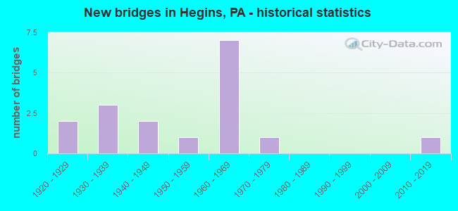
- New bridges - historical statistics
- 21920-1929
- 31930-1939
- 21940-1949
- 11950-1959
- 71960-1969
- 11970-1979
- 12010-2019

- Reconstructed bridges - Historical Statistics
- 11960-1969
- 01970-1979
- 41980-1989
- 01990-1999
- 02000-2009
- 02010-2019
- 12020-2022


- Bridge Condition - Deck
- 14.3%Excellent
- 7.1%Good
- 42.9%Satisfactory
- 21.4%Fair
- 14.3%Poor

- Bridge Condition - Superstructure
- 14.3%Excellent
- 14.3%Good
- 21.4%Satisfactory
- 28.6%Fair
- 21.4%Poor

- Bridge Condition - Substructure
- 7.1%Very good
- 7.1%Good
- 35.7%Satisfactory
- 28.6%Fair
- 21.4%Poor

- Bridge Condition - Channel
- 15.4%Very good
- 7.7%Good
- 15.4%Satisfactory
- 23.1%Fair
- 38.5%Poor
Find on map >> Show street view
Structure Number: 30568, Location: 0.75 MI.N.OF EXIT 107(33) (Lat: 40.627364, Lng: -76.448097), Route carried "on" structure: Interstate 81, Year Built: 1969, Year Reconstructed: 1988, Status: Open, Structure Length: 6.00m (19.69ft), Average Daily Traffic: 9,239 (year 2020), Truck Traffic: 37%, Average Future Daily Traffic: 14,181 (year 2032), Design Load: HS 20+Mod, Features Intersected: READING/NORTHERN RR
Minimum Vertical Clearance: 30+ m (98+ ft), Kilometerpoint: 17.271, Lanes on structure: 2, Base Highway Network: Yes, Owner: State Highway Agency, Approaching Roadway Width: 12.8m (42.0ft), Skew: 10 degrees, Material/Design: Prestressed concrete, Design/Construction: Box Beam or Girders - Single/Spread, Number Of Spans In Main Unit: 3, Length of Maximum Span: 19.5m (64.0ft), Curb-To-Curb Width: 11.9m (39.0ft), Out-to-Out Width: 13.2m (43.3ft)
Condition: Deck: Satisfactory, Superstructure: Fair, Substructure: Fair, Operating Rating: 65.3 metric tons, Method Used To Determine Operating Rating: Load Factor (LF), Inventory Rating: 37.2 metric tons, Method Used To Determine Inventory Rating: Load Factor (LF), Structural Evaluation: Somewhat better than minimum adequacy, Deck Geometry: Equal to present minimum criteria, Underclear: High priority of corrective action, Approach Roadway Alignment: Equal to present desirable criteria, Length Of Structure Improvement: 7.00m (22.97ft), Designated Inspection Frequency: Every 24 months, Inspection Date: April 2021, Deck Structure Type: Concrete Cast-file-Place, Wearing Surface/Protective System: Wearing Surface: Epoxy Overlay
Find on map >> Show street view
Structure Number: 30569, Location: 1 MI. N. OF EXIT 107 (33) (Lat: 40.629928, Lng: -76.447956), Route carried "on" structure: Interstate 81, Year Built: 1969, Year Reconstructed: 1988, Status: Open, Structure Length: 8.81m (28.90ft), Average Daily Traffic: 9,239 (year 2020), Truck Traffic: 37%, Average Future Daily Traffic: 14,181 (year 2032), Design Load: HS 20+Mod, Features Intersected: PA 125, GOOD SPRING CK.
Minimum Vertical Clearance: 30+ m (98+ ft), Kilometerpoint: 17.271, Lanes on structure: 2, Lanes under structure: 2, Base Highway Network: Yes, Owner: State Highway Agency, Approaching Roadway Width: 11.6m (38.1ft), Skew: 12 degrees, Material/Design: Steel continuous, Design/Construction: Stringer/Multi-beam, Number Of Spans In Main Unit: 3, Length of Maximum Span: 35.7m (117.1ft), Curb or Sidewalk Widths: Left: 0.2m (0.7ft), Right: 0.2m (0.7ft), Curb-To-Curb Width: 12.2m (40.0ft), Out-to-Out Width: 13.4m (44.0ft)
Condition: Deck: Satisfactory, Superstructure: Satisfactory, Substructure: Satisfactory, Channel: Satisfactory, Operating Rating: 57.2 metric tons, Method Used To Determine Operating Rating: Load Factor (LF), Inventory Rating: 34.5 metric tons, Method Used To Determine Inventory Rating: Load Factor (LF), Structural Evaluation: Equal to present minimum criteria, Deck Geometry: Better than present minimum criteria, Underclear: Superior to present desirable criteria, Waterway Adequacy: Superior to present desirable criteria, Approach Roadway Alignment: Equal to present desirable criteria, Length Of Structure Improvement: 9.80m (32.15ft), Designated Inspection Frequency: Every 24 months, Inspection Date: April 2020, Deck Structure Type: Concrete Cast-file-Place, Wearing Surface/Protective System: Wearing Surface: Epoxy Overlay
Find on map >> Show street view
Structure Number: 3057, Location: 0.75 MI.N.OF EXIT 107(33) (Lat: 40.627044, Lng: -76.448419), Route carried "on" structure: Interstate 81, Year Built: 1969, Year Reconstructed: 1988, Status: Open, Structure Length: 5.36m (17.59ft), Average Daily Traffic: 9,865 (year 2020), Truck Traffic: 37%, Average Future Daily Traffic: 15,784 (year 2032), Design Load: HS 20+Mod, Features Intersected: READING & NORTHERN RR
Minimum Vertical Clearance: 30+ m (98+ ft), Kilometerpoint: 17.104, Lanes on structure: 2, Base Highway Network: Yes, Owner: State Highway Agency, Approaching Roadway Width: 12.8m (42.0ft), Skew: 10 degrees, Material/Design: Prestressed concrete, Design/Construction: Box Beam or Girders - Single/Spread, Number Of Spans In Main Unit: 3, Length of Maximum Span: 17.4m (57.1ft), Curb or Sidewalk Widths: Left: 0.2m (0.7ft), Right: 0.2m (0.7ft), Curb-To-Curb Width: 11.9m (39.0ft), Out-to-Out Width: 13.2m (43.3ft)
Condition: Deck: Satisfactory, Superstructure: Fair, Substructure: Satisfactory, Operating Rating: 49.0 metric tons, Method Used To Determine Operating Rating: Load Factor (LF), Inventory Rating: 29.0 metric tons, Method Used To Determine Inventory Rating: Load Factor (LF), Structural Evaluation: Somewhat better than minimum adequacy, Deck Geometry: Equal to present minimum criteria, Underclear: High priority of corrective action, Approach Roadway Alignment: Equal to present desirable criteria, Length Of Structure Improvement: 6.30m (20.67ft), Designated Inspection Frequency: Every 24 months, Inspection Date: August 2020, Deck Structure Type: Concrete Cast-file-Place, Wearing Surface/Protective System: Wearing Surface: Epoxy Overlay
Find on map >> Show street view
Structure Number: 30571, Location: 1 MI. N. OF EXIT 107 (33) (Lat: 40.629656, Lng: -76.448461), Route carried "on" structure: Interstate 81, Year Built: 1969, Year Reconstructed: 1988, Status: Open, Structure Length: 9.27m (30.41ft), Average Daily Traffic: 9,865 (year 2020), Truck Traffic: 37%, Average Future Daily Traffic: 15,784 (year 2032), Design Load: HS 20+Mod, Features Intersected: PA 125, GOOD SPRING
Minimum Vertical Clearance: 30+ m (98+ ft), Kilometerpoint: 17.104, Lanes on structure: 2, Lanes under structure: 2, Base Highway Network: Yes, Owner: State Highway Agency, Approaching Roadway Width: 11.6m (38.1ft), Skew: 12 degrees, Material/Design: Steel continuous, Design/Construction: Stringer/Multi-beam, Number Of Spans In Main Unit: 3, Length of Maximum Span: 35.1m (115.2ft), Curb or Sidewalk Widths: Left: 0.2m (0.7ft), Right: 0.2m (0.7ft), Curb-To-Curb Width: 12.2m (40.0ft), Out-to-Out Width: 13.4m (44.0ft)
Condition: Deck: Satisfactory, Superstructure: Good, Substructure: Satisfactory, Channel: Very good, Operating Rating: 60.8 metric tons, Method Used To Determine Operating Rating: Load Factor (LF), Inventory Rating: 36.3 metric tons, Method Used To Determine Inventory Rating: Load Factor (LF), Structural Evaluation: Equal to present minimum criteria, Deck Geometry: Better than present minimum criteria, Underclear: Superior to present desirable criteria, Waterway Adequacy: Superior to present desirable criteria, Approach Roadway Alignment: Equal to present desirable criteria, Length Of Structure Improvement: 10.20m (33.46ft), Designated Inspection Frequency: Every 24 months, Inspection Date: August 2020, Deck Structure Type: Concrete Cast-file-Place, Wearing Surface/Protective System: Wearing Surface: Epoxy Overlay
Find on map >> Show street view
Structure Number: 30617, Location: 0.5 MI.S.OF HEGINS (Lat: 40.644200, Lng: -76.495883), Route carried "on" structure: State highway 125, Year Built: 1937, Year Reconstructed: 1965, Status: Open, Structure Length: 1.86m (6.10ft), Average Daily Traffic: 1,235 (year 2022), Truck Traffic: 6%, Average Future Daily Traffic: 2,120 (year 2032), Design Load: HS 20, Features Intersected: PINE CREEK
Minimum Vertical Clearance: 30+ m (98+ ft), Kilometerpoint: 23.197, Lanes on structure: 2, Owner: State Highway Agency, Approaching Roadway Width: 7.9m (25.9ft), Skew: 1 degrees, Material/Design: Steel, Design/Construction: Stringer/Multi-beam, Number Of Spans In Main Unit: 1, Length of Maximum Span: 17.4m (57.1ft), Curb-To-Curb Width: 7.3m (24.0ft), Out-to-Out Width: 7.9m (25.9ft)
Condition: Deck: Fair, Superstructure: Poor, Substructure: Poor, Channel: Poor, Operating Rating: 46.3 metric tons, Method Used To Determine Operating Rating: Load Factor (LF), Inventory Rating: 27.2 metric tons, Method Used To Determine Inventory Rating: Load Factor (LF), Structural Evaluation: Meets minimum limits, Deck Geometry: Meets minimum limits, Waterway Adequacy: Equal to present minimum criteria, Approach Roadway Alignment: Better than present minimum criteria, Length Of Structure Improvement: 2.50m (8.20ft), Designated Inspection Frequency: Every 24 months, Other Special Inspection Frequency: Every 12 months, Inspection Date: September 2021, Other Special Inspection Date: September 2021, Bridge Improvement Cost: $5,000, Roadway Improvement Cost: $14,000, Total Project Cost: $64,000, Deck Structure Type: Open Grating
Find on map >> Show street view
Structure Number: 30619, Location: 0.5 MI.N.OF HEGINS (Lat: 40.659656, Lng: -76.498478), Route carried "on" structure: State highway 125, Year Built: 1955, Status: Open, Structure Length: 1.92m (6.30ft), Average Daily Traffic: 2,085 (year 2020), Truck Traffic: 8%, Average Future Daily Traffic: 2,534 (year 2032), Design Load: HS 20, Features Intersected: DEEP CREEK
Minimum Vertical Clearance: 30+ m (98+ ft), Kilometerpoint: 24.697, Lanes on structure: 2, Owner: State Highway Agency, Approaching Roadway Width: 7.9m (25.9ft), Material/Design: Steel, Design/Construction: Stringer/Multi-beam, Number Of Spans In Main Unit: 1, Length of Maximum Span: 17.4m (57.1ft), Curb-To-Curb Width: 9.8m (32.2ft), Out-to-Out Width: 10.7m (35.1ft)
Condition: Deck: Poor, Superstructure: Poor, Substructure: Fair, Channel: Poor, Operating Rating: 38.1 metric tons, Method Used To Determine Operating Rating: Load Factor (LF), Inventory Rating: 22.7 metric tons, Method Used To Determine Inventory Rating: Load Factor (LF), Structural Evaluation: Meets minimum limits, Deck Geometry: Meets minimum limits, Waterway Adequacy: Superior to present desirable criteria, Approach Roadway Alignment: Equal to present desirable criteria, Length Of Structure Improvement: 2.60m (8.53ft), Designated Inspection Frequency: Every 24 months, Inspection Date: August 2020, Deck Structure Type: Concrete Cast-file-Place, Wearing Surface/Protective System: Wearing Surface: Monolithic Concrete
Find on map >> Show street view
Structure Number: 30821, Location: .4 MI.S.OF FOUNTAIN (Lat: 40.649564, Lng: -76.445881), Route carried "on" structure: State highway , Year Built: 1962, Status: Open, Structure Length: 0.94m (3.08ft), Average Daily Traffic: 81 (year 2022), Truck Traffic: 6%, Average Future Daily Traffic: 115 (year 2032), Design Load: HS 20, Features Intersected: PINE CREEK, Facility Carried by Structure: SR 4009 (LR 53030)
Minimum Vertical Clearance: 30+ m (98+ ft), Kilometerpoint: 3.879, Lanes on structure: 2, Owner: State Highway Agency, Approaching Roadway Width: 6.4m (21.0ft), Skew: 2 degrees, Material/Design: Concrete, Design/Construction: Slab, Number Of Spans In Main Unit: 1, Length of Maximum Span: 9.1m (29.9ft), Curb or Sidewalk Widths: Left: 0.4m (1.3ft), Right: 0.4m (1.3ft), Curb-To-Curb Width: 9.1m (29.9ft), Out-to-Out Width: 10.8m (35.4ft)
Condition: Deck: Satisfactory, Superstructure: Satisfactory, Substructure: Satisfactory, Channel: Fair, Operating Rating: 55.3 metric tons, Method Used To Determine Operating Rating: Load Factor (LF), Inventory Rating: 32.7 metric tons, Method Used To Determine Inventory Rating: Load Factor (LF), Structural Evaluation: Equal to present minimum criteria, Deck Geometry: Better than present minimum criteria, Waterway Adequacy: Better than present minimum criteria, Approach Roadway Alignment: Equal to present desirable criteria, Length Of Structure Improvement: 1.60m (5.25ft), Designated Inspection Frequency: Every 24 months, Inspection Date: September 2021, Wearing Surface/Protective System: Wearing Surface: Monolithic Concrete
Find on map >> Show street view
Structure Number: 30861, Location: VILLAGE OF HAAS (Lat: 40.700681, Lng: -76.494117), Route carried "on" structure: State highway , Year Built: 1946, Status: Open, Structure Length: 1.98m (6.50ft), Average Daily Traffic: 354 (year 2022), Truck Traffic: 7%, Average Future Daily Traffic: 368 (year 2032), Design Load: HS 20, Features Intersected: MAHANTANGO CREEK, Facility Carried by Structure: SR 4039 (LR 53055)
Minimum Vertical Clearance: 30+ m (98+ ft), Kilometerpoint: 0.000, Lanes on structure: 2, Owner: State Highway Agency, Approaching Roadway Width: 7.9m (25.9ft), Skew: 4 degrees, Material/Design: Steel, Design/Construction: Stringer/Multi-beam, Number Of Spans In Main Unit: 1, Length of Maximum Span: 18.9m (62.0ft), Curb or Sidewalk Widths: Left: 0.2m (0.7ft), Right: 0.2m (0.7ft), Curb-To-Curb Width: 7.9m (25.9ft), Out-to-Out Width: 8.8m (28.9ft)
Condition: Deck: Fair, Superstructure: Satisfactory, Substructure: Fair, Channel: Poor, Operating Rating: 58.1 metric tons, Method Used To Determine Operating Rating: Load Factor (LF), Inventory Rating: 34.5 metric tons, Method Used To Determine Inventory Rating: Load Factor (LF), Structural Evaluation: Somewhat better than minimum adequacy, Deck Geometry: Somewhat better than minimum adequacy, Waterway Adequacy: Better than present minimum criteria, Approach Roadway Alignment: Somewhat better than minimum adequacy, Length Of Structure Improvement: 2.70m (8.86ft), Designated Inspection Frequency: Every 24 months, Inspection Date: June 2020, Bridge Improvement Cost: $64,000, Roadway Improvement Cost: $189,000, Total Project Cost: $866,000, Deck Structure Type: Concrete Cast-file-Place, Wearing Surface/Protective System: Wearing Surface: Bituminous
Find on map >> Show street view
Structure Number: 30869, Location: SOUTH OF WEISHAMPLE (Lat: 40.684922, Lng: -76.438697), Route carried "on" structure: City street , Year Built: 1970, Year Reconstructed: 2020, Status: Open, Structure Length: 1.74m (5.71ft), Average Daily Traffic: 300 (year 1985), Average Future Daily Traffic: 600 (year 2030), Design Load: HL 93, Features Intersected: DEEP CREEK, Facility Carried by Structure: WEISHAMPLE RD.
Minimum Vertical Clearance: 30+ m (98+ ft), Kilometerpoint: 0.000, Lanes on structure: 2, Owner: County Highway Agency, Approaching Roadway Width: 7.6m (24.9ft), Material/Design: Prestressed concrete, Design/Construction: Box Beam or Girders - Single/Spread, Number Of Spans In Main Unit: 1, Length of Maximum Span: 16.5m (54.1ft), Curb-To-Curb Width: 7.8m (25.6ft), Out-to-Out Width: 8.4m (27.6ft)
Condition: Deck: Excellent, Superstructure: Excellent, Substructure: Good, Channel: Good, Operating Rating: 43.7 metric tons, Method Used To Determine Operating Rating: Assigned ratings based on Load and Resistance Factor Design (LRFD) reported by rating factor (RF) using HL93 loadings, Inventory Rating: 33.0 metric tons, Method Used To Determine Inventory Rating: Assigned ratings based on Load and Resistance Factor Design (LRFD) reported by rating factor (RF) using HL93 loadings, Structural Evaluation: Better than present minimum criteria, Deck Geometry: Somewhat better than minimum adequacy, Waterway Adequacy: Superior to present desirable criteria, Approach Roadway Alignment: Equal to present desirable criteria, Length Of Structure Improvement: 2.60m (8.53ft), Designated Inspection Frequency: Every 24 months, Inspection Date: April 2020, Bridge Improvement Cost: $5,000, Roadway Improvement Cost: $15,000, Total Project Cost: $70,000, Wearing Surface/Protective System: Wearing Surface: Monolithic Concrete, Deck Protection: Epoxy Coated Reinforcing
Find on map >> Show street view
Structure Number: 30892, Location: EAST OF HAAS (Lat: 40.711514, Lng: -76.474767), Route carried "on" structure: City street , Year Built: 1940, Status: Open, Structure Length: 0.85m (2.79ft), Average Daily Traffic: 200 (year 1985), Average Future Daily Traffic: 700 (year 2030), Design Load: H 15, Features Intersected: MAHANTANGO CREEK, Facility Carried by Structure: TAYLORSVILLE RD
Minimum Vertical Clearance: 30+ m (98+ ft), Kilometerpoint: 0.000, Lanes on structure: 2, Owner: Town or Township Highway Agency, Approaching Roadway Width: 6.4m (21.0ft), Skew: 4 degrees, Material/Design: Concrete, Design/Construction: Tee Beam, Number Of Spans In Main Unit: 1, Length of Maximum Span: 7.9m (25.9ft), Curb-To-Curb Width: 7.4m (24.3ft), Out-to-Out Width: 8.4m (27.6ft)
Condition: Deck: Good, Superstructure: Good, Substructure: Satisfactory, Channel: Satisfactory, Operating Rating: 50.8 metric tons, Method Used To Determine Operating Rating: Load Factor (LF), Inventory Rating: 30.8 metric tons, Method Used To Determine Inventory Rating: Load Factor (LF), Structural Evaluation: Equal to present minimum criteria, Deck Geometry: Somewhat better than minimum adequacy, Waterway Adequacy: Better than present minimum criteria, Approach Roadway Alignment: Better than present minimum criteria, Length Of Structure Improvement: 0.91m (2.99ft), Designated Inspection Frequency: Every 24 months, Inspection Date: November 2020, Bridge Improvement Cost: $3,000, Roadway Improvement Cost: $24,000, Total Project Cost: $36,000, Deck Structure Type: Concrete Cast-file-Place, Wearing Surface/Protective System: Wearing Surface: Bituminous
Find on map >> Show street view
Structure Number: 30893, Location: T377 IN HEGINS TWP (Lat: 40.677253, Lng: -76.459558), Route carried "on" structure: City street , Year Built: 1922, Status: Open, Structure Length: 1.65m (5.41ft), Average Daily Traffic: 100 (year 1980), Truck Traffic: 1%, Average Future Daily Traffic: 140 (year 2000), Design Load: H 10, Features Intersected: DEEP CREEK, Facility Carried by Structure: VALLEY ROAD T-377
Minimum Vertical Clearance: 30+ m (98+ ft), Kilometerpoint: 0.000, Lanes on structure: 2, Owner: County Highway Agency, Approaching Roadway Width: 5.2m (17.1ft), Material/Design: Concrete, Design/Construction: Tee Beam, Number Of Spans In Main Unit: 2, Length of Maximum Span: 7.3m (24.0ft), Curb-To-Curb Width: 6.1m (20.0ft), Out-to-Out Width: 6.7m (22.0ft)
Condition: Deck: Satisfactory, Superstructure: Fair, Substructure: Poor, Channel: Fair, Operating Rating: 72.6 metric tons, Method Used To Determine Operating Rating: Load Factor (LF), Inventory Rating: 43.5 metric tons, Method Used To Determine Inventory Rating: Load Factor (LF), Structural Evaluation: Meets minimum limits, Deck Geometry: Somewhat better than minimum adequacy, Waterway Adequacy: Better than present minimum criteria, Approach Roadway Alignment: Somewhat better than minimum adequacy, Length Of Structure Improvement: 2.30m (7.55ft), Designated Inspection Frequency: Every 24 months, Inspection Date: April 2020, Deck Structure Type: Concrete Cast-file-Place, Wearing Surface/Protective System: Wearing Surface: Bituminous
Find on map >> Show street view
Structure Number: 30902, Location: HEGINS T520 AT PINE CREEK (Lat: 40.647597, Lng: -76.459900), Route carried "on" structure: City street T520, Year Built: 1930, Status: Posted for load, Structure Length: 0.85m (2.79ft), Average Daily Traffic: 150 (year 2005), Truck Traffic: 15%, Average Future Daily Traffic: 150 (year 2025), Design Load: HS 20, Features Intersected: PINE CREEK, Facility Carried by Structure: PINE DRIVE
Minimum Vertical Clearance: 30+ m (98+ ft), Kilometerpoint: 0.000, Lanes on structure: 2, Owner: Town or Township Highway Agency, Approaching Roadway Width: 4.9m (16.1ft), Material/Design: Steel, Design/Construction: Stringer/Multi-beam, Number Of Spans In Main Unit: 1, Length of Maximum Span: 7.9m (25.9ft), Curb-To-Curb Width: 5.5m (18.0ft), Out-to-Out Width: 6.2m (20.3ft)
Condition: Deck: Poor, Superstructure: Poor, Substructure: Fair, Channel: Fair, Operating Rating: 34.5 metric tons, Method Used To Determine Operating Rating: Load Factor (LF), Inventory Rating: 20.9 metric tons, Method Used To Determine Inventory Rating: Load Factor (LF), Structural Evaluation: Meets minimum limits, Deck Geometry: High priority of corrective action, Waterway Adequacy: Equal to present minimum criteria, Approach Roadway Alignment: Equal to present desirable criteria, Bridge Posting: Required (Relationship of Operating Rating to Maximum Legal Load: 20.0 - 29.9% below), Length Of Structure Improvement: 1.30m (4.27ft), Designated Inspection Frequency: Every 24 months, Other Special Inspection Frequency: Every 12 months, Inspection Date: June 2020, Other Special Inspection Date: June 2021, Bridge Improvement Cost: $32,000, Roadway Improvement Cost: $128,000, Total Project Cost: $384,000, Deck Structure Type: Corrugated Steel, Wearing Surface/Protective System: Wearing Surface: Bituminous
Find on map >> Show street view
Structure Number: 30903, Location: NE OF HEGINS T-524 (Lat: 40.671044, Lng: -76.476383), Route carried "on" structure: City street , Year Built: 1922, Status: Open, Structure Length: 2.04m (6.69ft), Average Daily Traffic: 150 (year 1980), Truck Traffic: 1%, Average Future Daily Traffic: 150 (year 1986), Design Load: H 10, Features Intersected: DEEP CREEK, Facility Carried by Structure: BRIDGE ROAD T-524
Minimum Vertical Clearance: 30+ m (98+ ft), Kilometerpoint: 0.000, Lanes on structure: 2, Owner: County Highway Agency, Approaching Roadway Width: 4.9m (16.1ft), Skew: 3 degrees, Material/Design: Concrete, Design/Construction: Tee Beam, Number Of Spans In Main Unit: 2, Length of Maximum Span: 9.1m (29.9ft), Curb-To-Curb Width: 6.1m (20.0ft), Out-to-Out Width: 6.7m (22.0ft)
Condition: Deck: Fair, Superstructure: Fair, Substructure: Poor, Channel: Poor, Operating Rating: 69.9 metric tons, Method Used To Determine Operating Rating: Load Factor (LF), Inventory Rating: 41.7 metric tons, Method Used To Determine Inventory Rating: Load Factor (LF), Structural Evaluation: Meets minimum limits, Deck Geometry: Meets minimum limits, Waterway Adequacy: Better than present minimum criteria, Approach Roadway Alignment: Meets minimum limits, Length Of Structure Improvement: 2.00m (6.56ft), Designated Inspection Frequency: Every 24 months, Inspection Date: April 2020, Bridge Improvement Cost: $9,000, Roadway Improvement Cost: $25,000, Total Project Cost: $117,000, Deck Structure Type: Concrete Cast-file-Place, Wearing Surface/Protective System: Wearing Surface: Bituminous
Find on map >> Show street view
Structure Number: 30904, Location: SE OF HEGGINS (Lat: 40.644772, Lng: -76.470372), Route carried "on" structure: City street , Year Built: 1930, Status: Open, Structure Length: 0.98m (3.22ft), Average Daily Traffic: 30 (year 2003), Truck Traffic: 5%, Average Future Daily Traffic: 404 (year 2030), Features Intersected: PINE CREEK, Facility Carried by Structure: BROOK STREET
Minimum Vertical Clearance: 30+ m (98+ ft), Kilometerpoint: 0.000, Lanes on structure: 1, Owner: Town or Township Highway Agency, Approaching Roadway Width: 4.0m (13.1ft), Material/Design: Concrete, Design/Construction: Culvert, Number Of Spans In Main Unit: 4, Length of Maximum Span: 1.8m (5.9ft), Curb-To-Curb Width: 4.5m (14.8ft), Out-to-Out Width: 5.1m (16.7ft)
Condition: Channel: Poor, Culverts: Poor, Operating Rating: 49.0 metric tons, Method Used To Determine Operating Rating: Field evaluation and documented engineering judgment, Inventory Rating: 32.7 metric tons, Method Used To Determine Inventory Rating: Field evaluation and documented engineering judgment, Structural Evaluation: Meets minimum limits, Deck Geometry: Equal to present minimum criteria, Waterway Adequacy: Meets minimum limits, Approach Roadway Alignment: Equal to present desirable criteria, Length Of Structure Improvement: 1.10m (3.61ft), Designated Inspection Frequency: Every 24 months, Inspection Date: April 2021, Bridge Improvement Cost: $59,000, Roadway Improvement Cost: $60,000, Total Project Cost: $285,000
Find on map >> Show street view
Structure Number: 52588, Location: VILLAGE OF HAAS (Lat: 40.700689, Lng: -76.494136), Route carried "on" structure: State highway , Year Built: 2015, Status: Open, Structure Length: 1.74m (5.71ft), Average Daily Traffic: 354 (year 2022), Truck Traffic: 7%, Average Future Daily Traffic: 316 (year 2037), Design Load: HL 93, Features Intersected: Mahantango Creek, Facility Carried by Structure: Creek Rd (SR 4039)
Minimum Vertical Clearance: 30+ m (98+ ft), Kilometerpoint: 0.019, Lanes on structure: 2, Owner: State Highway Agency, Maintenance Responsibility: Private, Approaching Roadway Width: 5.2m (17.1ft), Material/Design: Prestressed concrete, Design/Construction: Box Beam or Girders - Single/Spread, Number Of Spans In Main Unit: 1, Length of Maximum Span: 16.2m (53.1ft), Curb-To-Curb Width: 6.8m (22.3ft), Out-to-Out Width: 7.4m (24.3ft)
Condition: Deck: Excellent, Superstructure: Excellent, Substructure: Very good, Channel: Very good, Operating Rating: 47.3 metric tons, Method Used To Determine Operating Rating: Assigned ratings based on Load and Resistance Factor Design (LRFD) reported by rating factor (RF) using HL93 loadings, Inventory Rating: 36.3 metric tons, Method Used To Determine Inventory Rating: Assigned ratings based on Load and Resistance Factor Design (LRFD) reported by rating factor (RF) using HL93 loadings, Structural Evaluation: Equal to present desirable criteria, Deck Geometry: Meets minimum limits, Waterway Adequacy: Superior to present desirable criteria, Approach Roadway Alignment: Equal to present desirable criteria, Designated Inspection Frequency: Every 24 months, Inspection Date: April 2021, Deck Structure Type: Concrete Cast-file-Place, Wearing Surface/Protective System: Wearing Surface: Integral Concrete, Deck Protection: Epoxy Coated Reinforcing
Find on map >> Show street view
Structure Number: 30569, Location: 1 MI. N. OF EXIT 107 (33) (Lat: 40.629928, Lng: -76.447956), Route carried "under" structure: State highway 125, Year Built: 1969, Structure Length: 0. m, Average Daily Traffic: 330 (year 2020), Truck Traffic: 8%, Features Intersected: PA 125, GOOD SPRING CK., Facility Carried by Structure: I-81 NB (LR 1005)
Minimum Vertical Clearance: 11.70m (38.39ft), Kilometerpoint: 16.481, Lanes on structure: 2, Lanes under structure: 2, Material/Design: Steel continuous, Design/Construction: Stringer/Multi-beam, Length of Maximum Span: 35.7m (117.1ft)
Find on map >> Show street view
Structure Number: 30571, Location: 1 MI. N. OF EXIT 107 (33) (Lat: 40.629656, Lng: -76.448461), Route carried "under" structure: State highway 125, Year Built: 1969, Structure Length: 0. m, Average Daily Traffic: 330 (year 2020), Truck Traffic: 8%, Features Intersected: PA 125, GOOD SPRING, Facility Carried by Structure: I-81 SB (LR 1005)
Minimum Vertical Clearance: 13.14m (43.11ft), Kilometerpoint: 16.481, Lanes on structure: 2, Lanes under structure: 2, Material/Design: Steel continuous, Design/Construction: Stringer/Multi-beam, Length of Maximum Span: 35.1m (115.2ft)