Bridge Statistics for Harwick, Pennsylvania (PA)
Condition, Traffic, Stress, Structural Evaluation, Project Costs
- National Bridge Inventory (NBI) Statistics
- 17Number of bridges
- 128ft / 38.9mTotal length
- $2,371,000Total costs
- 227,973Total average daily traffic
- 11,317Total average daily truck traffic
- National Bridge Inventory (NBI) Registered Bridges for Harwick
- No street view available for this location
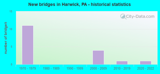
- New bridges - historical statistics
- 111970-1979
- 42000-2009
- 12010-2019
- 12020-2022

- Reconstructed bridges - Historical Statistics
- 22000-2009
- 12010-2019


- Bridge Condition - Deck
- 14.3%Excellent
- 14.3%Very good
- 71.4%Good

- Bridge Condition - Superstructure
- 14.3%Excellent
- 28.6%Very good
- 42.9%Good
- 14.3%Satisfactory

- Bridge Condition - Substructure
- 14.3%Very good
- 71.4%Good
- 14.3%Satisfactory

- Bridge Condition - Channel
- 50.0%Very good
- 50.0%Good
Find on map >> Show street view
Structure Number: 64, Location: LR 1037 NB OVER LR 02169 (Lat: 40.557594, Lng: -79.805039), Route carried "on" structure: State highway 28, Year Built: 1970, Year Reconstructed: 2008, Status: Open, Structure Length: 3.41m (11.19ft), Average Daily Traffic: 22,655 (year 2022), Truck Traffic: 5%, Average Future Daily Traffic: 23,101 (year 2032), Design Load: HS 20, Features Intersected: SR 1017-YUTES RUN RD
Minimum Vertical Clearance: 30+ m (98+ ft), Kilometerpoint: 22.758, Lanes on structure: 3, Lanes under structure: 2, Base Highway Network: Yes, Owner: State Highway Agency, Approaching Roadway Width: 17.1m (56.1ft), Skew: 10 degrees, Material/Design: Concrete continuous, Design/Construction: Slab, Number Of Spans In Main Unit: 3, Length of Maximum Span: 13.7m (44.9ft), Curb or Sidewalk Widths: Left: 0.3m (1.0ft), Right: 0.3m (1.0ft), Curb-To-Curb Width: 16.7m (54.8ft), Out-to-Out Width: 17.7m (58.1ft)
Condition: Deck: Good, Superstructure: Good, Substructure: Satisfactory, Operating Rating: 59.0 metric tons, Method Used To Determine Operating Rating: Load Factor (LF), Inventory Rating: 35.4 metric tons, Method Used To Determine Inventory Rating: Load Factor (LF), Structural Evaluation: Equal to present minimum criteria, Deck Geometry: Equal to present minimum criteria, Underclear: Meets minimum limits, Approach Roadway Alignment: Equal to present desirable criteria, Length Of Structure Improvement: 3.40m (11.15ft), Designated Inspection Frequency: Every 24 months, Inspection Date: June 2021, Bridge Improvement Cost: $19,000, Roadway Improvement Cost: $55,000, Total Project Cost: $254,000, Deck Structure Type: Concrete Cast-file-Place, Wearing Surface/Protective System: Wearing Surface: Latex Concrete
Find on map >> Show street view
Structure Number: 1421, Location: 1/4 MI. N.E. OF SR 0076 (Lat: 40.550000, Lng: -79.820000), Route carried "on" structure: State highway , Year Built: 1970, Year Reconstructed: 2008, Status: Open, Structure Length: 7.80m (25.59ft), Average Daily Traffic: 2,870 (year 2022), Truck Traffic: 3%, Average Future Daily Traffic: 9,081 (year 2032), Design Load: HS 20, Features Intersected: SR 0028 NB -SB, Facility Carried by Structure: LITTLE DEER CRE RD
Minimum Vertical Clearance: 30+ m (98+ ft), Kilometerpoint: 0.729, Lanes on structure: 3, Lanes under structure: 8, Owner: State Highway Agency, Approaching Roadway Width: 15.5m (50.9ft), Skew: 23 degrees, Material/Design: Steel, Design/Construction: Stringer/Multi-beam, Number Of Spans In Main Unit: 1, Number Of Approach Spans: 2, Length of Maximum Span: 45.4m (149.0ft), Curb or Sidewalk Widths: Left: 0.2m (0.7ft), Right: 0.2m (0.7ft), Curb-To-Curb Width: 22.3m (73.2ft), Out-to-Out Width: 23.2m (76.1ft)
Condition: Deck: Good, Superstructure: Good, Substructure: Good, Operating Rating: 66.2 metric tons, Method Used To Determine Operating Rating: Load Factor (LF), Inventory Rating: 39.0 metric tons, Method Used To Determine Inventory Rating: Load Factor (LF), Structural Evaluation: Better than present minimum criteria, Deck Geometry: Superior to present desirable criteria, Underclear: High priority of corrective action, Approach Roadway Alignment: Equal to present desirable criteria, Length Of Structure Improvement: 7.80m (25.59ft), Designated Inspection Frequency: Every 24 months, Inspection Date: January 2021, Bridge Improvement Cost: $44,000, Roadway Improvement Cost: $129,000, Total Project Cost: $592,000, Deck Structure Type: Concrete Cast-file-Place, Wearing Surface/Protective System: Wearing Surface: Monolithic Concrete
Find on map >> Show street view
Structure Number: 1436, Location: 50' NORTH OF SR 1014 (Lat: 40.571444, Lng: -79.790547), Route carried "on" structure: State highway , Year Built: 1974, Year Reconstructed: 2019, Status: Open, Structure Length: 12.65m (41.50ft), Average Daily Traffic: 1,650 (year 2020), Truck Traffic: 4%, Average Future Daily Traffic: 2,255 (year 2032), Design Load: HS 20, Features Intersected: OVER 28 NB SB, Facility Carried by Structure: BUTLER LOGAN RD
Minimum Vertical Clearance: 30+ m (98+ ft), Kilometerpoint: 3.945, Lanes on structure: 2, Lanes under structure: 8, Owner: State Highway Agency, Approaching Roadway Width: 11.0m (36.1ft), Skew: 3 degrees, Material/Design: Steel continuous, Design/Construction: Stringer/Multi-beam, Number Of Spans In Main Unit: 4, Length of Maximum Span: 34.4m (112.9ft), Curb or Sidewalk Widths: Left: 0.2m (0.7ft), Right: 0.2m (0.7ft), Curb-To-Curb Width: 11.0m (36.1ft), Out-to-Out Width: 12.2m (40.0ft)
Condition: Deck: Good, Superstructure: Very good, Substructure: Good, Operating Rating: 76.2 metric tons, Method Used To Determine Operating Rating: Load Factor (LF), Inventory Rating: 45.4 metric tons, Method Used To Determine Inventory Rating: Load Factor (LF), Structural Evaluation: Better than present minimum criteria, Deck Geometry: Equal to present minimum criteria, Underclear: Better than present minimum criteria, Approach Roadway Alignment: Equal to present desirable criteria, Length Of Structure Improvement: 13.60m (44.62ft), Designated Inspection Frequency: Every 24 months, Inspection Date: June 2021, Bridge Improvement Cost: $106,000, Roadway Improvement Cost: $311,000, Total Project Cost: $1,426,000, Deck Structure Type: Concrete Cast-file-Place, Wearing Surface/Protective System: Wearing Surface: Bituminous, Deck Protection: Epoxy Coated Reinforcing
Find on map >> Show street view
Structure Number: 2316, Location: 1.5 M NORTH 76/28 INTER (Lat: 40.560028, Lng: -79.825964), Route carried "on" structure: City street 7208, Year Built: 2000, Status: Open, Structure Length: 3.78m (12.40ft), Average Daily Traffic: 1,500 (year 2019), Truck Traffic: 1%, Average Future Daily Traffic: 1,550 (year 2041), Design Load: HS 25 or greater, Features Intersected: B&LE RAILROAD, Facility Carried by Structure: NIXON RD
Minimum Vertical Clearance: 30+ m (98+ ft), Kilometerpoint: 0.000, Lanes on structure: 2, Owner: Town or Township Highway Agency, Approaching Roadway Width: 10.4m (34.1ft), Material/Design: Steel, Design/Construction: Stringer/Multi-beam, Number Of Spans In Main Unit: 3, Length of Maximum Span: 15.8m (51.8ft), Curb or Sidewalk Widths: Left: 0.2m (0.7ft), Right: 0.2m (0.7ft), Curb-To-Curb Width: 10.5m (34.4ft), Out-to-Out Width: 11.4m (37.4ft)
Condition: Deck: Good, Superstructure: Good, Substructure: Good, Operating Rating: 70.8 metric tons, Method Used To Determine Operating Rating: Load Factor (LF), Inventory Rating: 42.6 metric tons, Method Used To Determine Inventory Rating: Load Factor (LF), Structural Evaluation: Better than present minimum criteria, Deck Geometry: Equal to present minimum criteria, Underclear: High priority of corrective action, Approach Roadway Alignment: Somewhat better than minimum adequacy, Length Of Structure Improvement: 4.60m (15.09ft), Designated Inspection Frequency: Every 24 months, Inspection Date: May 2021, Bridge Improvement Cost: $7,000, Roadway Improvement Cost: $22,000, Total Project Cost: $99,000, Deck Structure Type: Concrete Cast-file-Place, Wearing Surface/Protective System: Wearing Surface: Monolithic Concrete
Find on map >> Show street view
Structure Number: 42919, Location: PGH MILLS MALL (Lat: 40.568642, Lng: -79.797664), Route carried "on" structure: State highway , Year Built: 2005, Status: Open, Structure Length: 8.50m (27.89ft), Average Daily Traffic: 12,416 (year 2021), Truck Traffic: 7%, Average Future Daily Traffic: 14,202 (year 2032), Design Load: HS 20, Features Intersected: SR 0028 NB SB, Facility Carried by Structure: PGH MILLS BLVD
Minimum Vertical Clearance: 3.96m (12.99ft), Kilometerpoint: 0.000, Lanes on structure: 5, Lanes under structure: 4, Owner: State Highway Agency, Approaching Roadway Width: 26.5m (86.9ft), Skew: 20 degrees, Material/Design: Prestressed concrete continuous, Design/Construction: Stringer/Multi-beam, Number Of Spans In Main Unit: 2, Length of Maximum Span: 41.8m (137.1ft), Curb or Sidewalk Widths: Left: 0.2m (0.7ft), Right: 0.2m (0.7ft), Curb-To-Curb Width: 26.5m (86.9ft), Out-to-Out Width: 27.6m (90.6ft)
Condition: Deck: Good, Superstructure: Satisfactory, Substructure: Good, Operating Rating: 69.9 metric tons, Method Used To Determine Operating Rating: Load and Resistance Factor (LRFR), Inventory Rating: 40.8 metric tons, Method Used To Determine Inventory Rating: Load and Resistance Factor (LRFR), Structural Evaluation: Equal to present minimum criteria, Deck Geometry: Superior to present desirable criteria, Underclear: Superior to present desirable criteria, Approach Roadway Alignment: Equal to present desirable criteria, Designated Inspection Frequency: Every 24 months, Inspection Date: January 2021, Deck Structure Type: Concrete Cast-file-Place, Wearing Surface/Protective System: Wearing Surface: Monolithic Concrete, Deck Protection: Epoxy Coated Reinforcing
Find on map >> Show street view
Structure Number: 52636, Location: 70' West of SR 1015 (Lat: 40.574519, Lng: -79.822511), Route carried "on" structure: State highway , Year Built: 2015, Status: Open, Structure Length: 1.07m (3.51ft), Average Daily Traffic: 381 (year 2022), Truck Traffic: 1%, Average Future Daily Traffic: 934 (year 2034), Design Load: HL 93, Features Intersected: Little Deer Creek, Facility Carried by Structure: SR 1016 Lafever H
Minimum Vertical Clearance: 30+ m (98+ ft), Kilometerpoint: 0.819, Lanes on structure: 2, Owner: State Highway Agency, Maintenance Responsibility: Private, Approaching Roadway Width: 7.9m (25.9ft), Material/Design: Prestressed concrete, Design/Construction: Box Beam or Girders - Single/Spread, Number Of Spans In Main Unit: 1, Length of Maximum Span: 10.1m (33.1ft), Curb-To-Curb Width: 8.1m (26.6ft), Out-to-Out Width: 8.7m (28.5ft)
Condition: Deck: Very good, Superstructure: Very good, Substructure: Very good, Channel: Good, Operating Rating: 57.7 metric tons, Method Used To Determine Operating Rating: Assigned ratings based on Load and Resistance Factor Design (LRFD) reported by rating factor (RF) using HL93 loadings, Inventory Rating: 44.4 metric tons, Method Used To Determine Inventory Rating: Assigned ratings based on Load and Resistance Factor Design (LRFD) reported by rating factor (RF) using HL93 loadings, Structural Evaluation: Equal to present desirable criteria, Deck Geometry: Somewhat better than minimum adequacy, Waterway Adequacy: Better than present minimum criteria, Approach Roadway Alignment: Equal to present desirable criteria, Designated Inspection Frequency: Every 24 months, Inspection Date: September 2020, Deck Structure Type: Concrete Cast-file-Place, Wearing Surface/Protective System: Wearing Surface: Integral Concrete, Deck Protection: Epoxy Coated Reinforcing
Find on map >> Show street view
Structure Number: 57085, Location: DL05 LIT DEER CRK NO. 5 (Lat: 40.561306, Lng: -79.830989), Route carried "on" structure: City street , Year Built: 2020, Status: Open, Structure Length: 1.65m (5.41ft), Average Daily Traffic: 484 (year 2020), Truck Traffic: 2%, Average Future Daily Traffic: 550 (year 2042), Design Load: HL 93, Features Intersected: LITTLE DEER CREEK, Facility Carried by Structure: JACOBY ROAD
Minimum Vertical Clearance: 30+ m (98+ ft), Kilometerpoint: 0.000, Lanes on structure: 2, Owner: County Highway Agency, Approaching Roadway Width: 6.7m (22.0ft), Skew: 2 degrees, Material/Design: Concrete, Design/Construction: Tee Beam, Number Of Spans In Main Unit: 1, Length of Maximum Span: 15.8m (51.8ft), Curb or Sidewalk Widths: Left: 0.2m (0.7ft), Right: 0.2m (0.7ft), Curb-To-Curb Width: 6.7m (22.0ft), Out-to-Out Width: 7.7m (25.3ft)
Condition: Deck: Excellent, Superstructure: Excellent, Substructure: Good, Channel: Very good, Operating Rating: 47.3 metric tons, Method Used To Determine Operating Rating: Assigned ratings based on Load and Resistance Factor Design (LRFD) reported by rating factor (RF) using HL93 loadings, Inventory Rating: 36.6 metric tons, Method Used To Determine Inventory Rating: Assigned ratings based on Load and Resistance Factor Design (LRFD) reported by rating factor (RF) using HL93 loadings, Structural Evaluation: Better than present minimum criteria, Deck Geometry: Meets minimum limits, Waterway Adequacy: Equal to present desirable criteria, Approach Roadway Alignment: Somewhat better than minimum adequacy, Designated Inspection Frequency: Every 24 months, Inspection Date: June 2020, Deck Structure Type: Concrete Cast-file-Place, Wearing Surface/Protective System: Wearing Surface: Monolithic Concrete, Deck Protection: Epoxy Coated Reinforcing
Find on map >> Show street view
Structure Number: 64, Location: LR 1037 NB OVER LR 02169 (Lat: 40.557594, Lng: -79.805039), Route carried "under" structure: State highway , Year Built: 1970, Structure Length: 0. m, Average Daily Traffic: 351 (year 2021), Truck Traffic: 12%, Features Intersected: SR 1017-YUTES RUN RD, Facility Carried by Structure: SR 0028 NB
Minimum Vertical Clearance: 4.72m (15.49ft), Kilometerpoint: 1.708, Lanes on structure: 3, Lanes under structure: 2, Material/Design: Concrete continuous, Design/Construction: Slab, Length of Maximum Span: 13.7m (44.9ft)
Find on map >> Show street view
Structure Number: 642, Location: RT 0028 SB OVER 1017 (Lat: 40.557772, Lng: -79.805244), Route carried "under" structure: State highway , Year Built: 1970, Structure Length: 0. m, Average Daily Traffic: 351 (year 2021), Truck Traffic: 12%, Features Intersected: SR 1017-YUTES RUN RD, Facility Carried by Structure: SR 0028 SB
Minimum Vertical Clearance: 4.72m (15.49ft), Kilometerpoint: 1.708, Lanes on structure: 2, Lanes under structure: 2, Material/Design: Concrete continuous, Design/Construction: Slab, Length of Maximum Span: 13.4m (44.0ft)
Find on map >> Show street view
Structure Number: 1417, Location: 0.7 MI. N.E.OF TURNPIKE (Lat: 40.555125, Lng: -79.811975), Route carried "under" structure: State highway 28, Year Built: 1970, Structure Length: 0. m, Average Daily Traffic: 19,866 (year 2022), Truck Traffic: 7%, Features Intersected: SR 0028 NB SB, Facility Carried by Structure: HITE RD
Minimum Vertical Clearance: 4.52m (14.83ft), Kilometerpoint: 21.699, Lanes on structure: 4, Lanes under structure: 5, Material/Design: Steel, Design/Construction: Stringer/Multi-beam, Length of Maximum Span: 80.5m (264.1ft)
Find on map >> Show street view
Structure Number: 1417, Location: 0.7 MI. N.E.OF TURNPIKE (Lat: 40.555125, Lng: -79.811975), Route carried "under" structure: State highway 28, Year Built: 1970, Structure Length: 0. m, Average Daily Traffic: 24,309 (year 2022), Truck Traffic: 4%, Features Intersected: SR 0028 NB SB, Facility Carried by Structure: HITE RD
Minimum Vertical Clearance: 4.60m (15.09ft), Kilometerpoint: 21.679, Lanes on structure: 4, Lanes under structure: 5, Material/Design: Steel, Design/Construction: Stringer/Multi-beam, Length of Maximum Span: 80.5m (264.1ft)
Find on map >> Show street view
Structure Number: 1421, Location: 1/4 MI. N.E. OF SR 0076 (Lat: 40.550000, Lng: -79.820000), Route carried "under" structure: State highway 28, Year Built: 1970, Structure Length: 0. m, Average Daily Traffic: 19,866 (year 2022), Truck Traffic: 7%, Features Intersected: SR 0028 NB -SB, Facility Carried by Structure: LITTLE DEER CRE RD
Minimum Vertical Clearance: 4.72m (15.49ft), Kilometerpoint: 21.699, Lanes on structure: 3, Lanes under structure: 4, Material/Design: Steel, Design/Construction: Stringer/Multi-beam, Length of Maximum Span: 45.4m (149.0ft)
Find on map >> Show street view
Structure Number: 1421, Location: 1/4 MI. N.E. OF SR 0076 (Lat: 40.550000, Lng: -79.820000), Route carried "under" structure: State highway 28, Year Built: 1970, Structure Length: 0. m, Average Daily Traffic: 27,346 (year 2022), Truck Traffic: 4%, Features Intersected: SR 0028 NB -SB, Facility Carried by Structure: LITTLE DEER CRE RD
Minimum Vertical Clearance: 6.53m (21.42ft), Kilometerpoint: 21.679, Lanes on structure: 3, Lanes under structure: 4, Material/Design: Steel, Design/Construction: Stringer/Multi-beam, Length of Maximum Span: 45.4m (149.0ft)
Find on map >> Show street view
Structure Number: 1436, Location: 50' NORTH OF SR 1014 (Lat: 40.571444, Lng: -79.790547), Route carried "under" structure: State highway 28, Year Built: 1974, Structure Length: 0. m, Average Daily Traffic: 22,655 (year 2022), Truck Traffic: 5%, Features Intersected: OVER 28 NB SB, Facility Carried by Structure: BUTLER LOGAN RD
Minimum Vertical Clearance: 18.90m (62.01ft), Kilometerpoint: 25.302, Lanes on structure: 2, Lanes under structure: 4, Material/Design: Steel continuous, Design/Construction: Stringer/Multi-beam, Length of Maximum Span: 34.4m (112.9ft)
Find on map >> Show street view
Structure Number: 1436, Location: 50' NORTH OF SR 1014 (Lat: 40.571444, Lng: -79.790547), Route carried "under" structure: State highway 28, Year Built: 1974, Structure Length: 0. m, Average Daily Traffic: 24,309 (year 2022), Truck Traffic: 4%, Features Intersected: OVER 28 NB SB, Facility Carried by Structure: BUTLER LOGAN RD
Minimum Vertical Clearance: 18.90m (62.01ft), Kilometerpoint: 25.275, Lanes on structure: 2, Lanes under structure: 4, Material/Design: Steel continuous, Design/Construction: Stringer/Multi-beam, Length of Maximum Span: 34.4m (112.9ft)
Find on map >> Show street view
Structure Number: 42919, Location: PGH MILLS MALL (Lat: 40.568642, Lng: -79.797664), Route carried "under" structure: Bypass State highway 28, Year Built: 2005, Structure Length: 0. m, Average Daily Traffic: 22,655 (year 2022), Truck Traffic: 5%, Features Intersected: SR 0028 NB SB, Facility Carried by Structure: PGH MILLS BLVD
Minimum Vertical Clearance: 5.83m (19.13ft), Kilometerpoint: 24.483, Lanes on structure: 5, Lanes under structure: 2, Material/Design: Prestressed concrete continuous, Design/Construction: Stringer/Multi-beam, Length of Maximum Span: 41.8m (137.1ft)
Find on map >> Show street view
Structure Number: 42919, Location: PGH MILLS MALL (Lat: 40.568642, Lng: -79.797664), Route carried "under" structure: Bypass State highway 28, Year Built: 2005, Structure Length: 0. m, Average Daily Traffic: 24,309 (year 2022), Truck Traffic: 4%, Features Intersected: SR 0028 NB SB, Facility Carried by Structure: PGH MILLS BLVD
Minimum Vertical Clearance: 5.83m (19.13ft), Kilometerpoint: 24.414, Lanes on structure: 5, Lanes under structure: 2, Material/Design: Prestressed concrete continuous, Design/Construction: Stringer/Multi-beam, Length of Maximum Span: 41.8m (137.1ft)