Bridge Statistics for Harveyville, Kansas (KS)
Condition, Traffic, Stress, Structural Evaluation, Project Costs
- National Bridge Inventory (NBI) Statistics
- 36Number of bridges
- 328ft / 100mTotal length
- $1,170,000Total costs
- 46,613Total average daily traffic
- 12,956Total average daily truck traffic
- National Bridge Inventory (NBI) Registered Bridges for Harveyville
- No street view available for this location
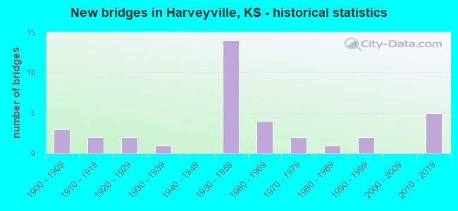
- New bridges - historical statistics
- 31900-1909
- 21910-1919
- 21920-1929
- 11930-1939
- 141950-1959
- 41960-1969
- 21970-1979
- 11980-1989
- 21990-1999
- 52010-2019

- Reconstructed bridges - Historical Statistics
- 31980-1989
- 41990-1999


- Bridge Condition - Deck
- 20.0%Very good
- 20.0%Good
- 48.0%Satisfactory
- 12.0%Fair

- Bridge Condition - Superstructure
- 24.0%Very good
- 36.0%Good
- 28.0%Satisfactory
- 12.0%Fair

- Bridge Condition - Substructure
- 28.0%Very good
- 28.0%Good
- 16.0%Satisfactory
- 24.0%Fair
- 4.0%Poor

- Bridge Condition - Channel
- 23.1%Very good
- 23.1%Good
- 46.2%Satisfactory
- 3.8%Fair
- 3.8%Poor

- Bridge Condition - Culverts
- 50.0%Good
- 50.0%Satisfactory
Find on map >> Show street view
Structure Number: 99006, Location: 1.0W 1.5S OF HARVEYVILLE (Lat: 38.767706, Lng: -95.983386), Route carried "on" structure: County highway 416, Year Built: 1951, Status: Posted for load, Structure Length: 3.26m (10.70ft), Average Daily Traffic: 130 (year 2013), Average Future Daily Traffic: 156 (year 2041), Design Load: H 15, Features Intersected: SOLDIER CREEK
Minimum Vertical Clearance: 30.47m (99.97ft), Kilometerpoint: 0.000, Lanes on structure: 2, Owner: County Highway Agency, Approaching Roadway Width: 6.7m (22.0ft), Material/Design: Concrete continuous, Design/Construction: Slab, Number Of Spans In Main Unit: 3, Length of Maximum Span: 12.2m (40.0ft), Curb-To-Curb Width: 7.4m (24.3ft), Out-to-Out Width: 8.7m (28.5ft)
Condition: Deck: Satisfactory, Superstructure: Good, Substructure: Fair, Channel: Satisfactory, Operating Rating: 30.5 metric tons, Method Used To Determine Operating Rating: Load Factor (LF), Inventory Rating: 18.2 metric tons, Method Used To Determine Inventory Rating: Load Factor (LF), Structural Evaluation: Somewhat better than minimum adequacy, Deck Geometry: Somewhat better than minimum adequacy, Waterway Adequacy: Better than present minimum criteria, Approach Roadway Alignment: Equal to present desirable criteria, Bridge Posting: Required (Relationship of Operating Rating to Maximum Legal Load: 10.0 - 19.9% below), Designated Inspection Frequency: Every 24 months, Inspection Date: December 2021, Deck Structure Type: Concrete Cast-file-Place
Find on map >> Show street view
Structure Number: 99009, Location: 0.5 N OF HARVEYVILLE (Lat: 38.799883, Lng: -95.964953), Route carried "on" structure: County highway 619, Year Built: 1999, Status: Open, Structure Length: 4.36m (14.30ft), Average Daily Traffic: 490 (year 2013), Average Future Daily Traffic: 588 (year 2041), Features Intersected: DRAGOON CREEK
Minimum Vertical Clearance: 30.47m (99.97ft), Kilometerpoint: 0.000, Lanes on structure: 2, Owner: County Highway Agency, Approaching Roadway Width: 6.0m (19.7ft), Skew: 3 degrees, Material/Design: Concrete continuous, Design/Construction: Slab, Number Of Spans In Main Unit: 3, Length of Maximum Span: 17.1m (56.1ft), Curb-To-Curb Width: 9.1m (29.9ft), Out-to-Out Width: 9.8m (32.2ft)
Condition: Deck: Good, Superstructure: Very good, Substructure: Very good, Channel: Very good, Operating Rating: 32.7 metric tons, Method Used To Determine Operating Rating: Field evaluation and documented engineering judgment, Inventory Rating: 32.7 metric tons, Method Used To Determine Inventory Rating: Field evaluation and documented engineering judgment, Structural Evaluation: Equal to present desirable criteria, Deck Geometry: Equal to present minimum criteria, Waterway Adequacy: Equal to present desirable criteria, Approach Roadway Alignment: Equal to present desirable criteria, Designated Inspection Frequency: Every 24 months, Inspection Date: December 2021, Deck Structure Type: Concrete Cast-file-Place
Find on map >> Show street view
Structure Number: 99042, Location: 4.3N 0.3E OF HARVEYVILLE (Lat: 38.840875, Lng: -95.958536), Route carried "on" structure: County highway 1466, Year Built: 1923, Status: Posted for load, Structure Length: 0.70m (2.30ft), Average Daily Traffic: 36 (year 2013), Average Future Daily Traffic: 46 (year 2041), Features Intersected: COON CREEK
Minimum Vertical Clearance: 30.47m (99.97ft), Kilometerpoint: 0.000, Lanes on structure: 2, Owner: County Highway Agency, Approaching Roadway Width: 6.0m (19.7ft), Material/Design: Concrete, Design/Construction: Slab, Number Of Spans In Main Unit: 1, Length of Maximum Span: 6.3m (20.7ft), Curb-To-Curb Width: 6.1m (20.0ft), Out-to-Out Width: 6.1m (20.0ft)
Condition: Deck: Satisfactory, Superstructure: Satisfactory, Substructure: Fair, Channel: Fair, Operating Rating: 90.5 metric tons, Method Used To Determine Operating Rating: Load Factor (LF), Inventory Rating: 54.2 metric tons, Method Used To Determine Inventory Rating: Load Factor (LF), Structural Evaluation: Somewhat better than minimum adequacy, Deck Geometry: Somewhat better than minimum adequacy, Waterway Adequacy: Equal to present minimum criteria, Approach Roadway Alignment: Equal to present desirable criteria, Designated Inspection Frequency: Every 24 months, Inspection Date: December 2021, Deck Structure Type: Concrete Cast-file-Place, Wearing Surface/Protective System: Wearing Surface: Other
Find on map >> Show street view
Structure Number: 70096910462, Location: 4.8N 5.9W OF BURLINGAME (Lat: 38.826383, Lng: -95.946567), Route carried "on" structure: County highway , Year Built: 1935, Status: Posted for load, Structure Length: 0.63m (2.07ft), Average Daily Traffic: 45 (year 2013), Average Future Daily Traffic: 54 (year 2039), Features Intersected: UNNAMED STREAM, Facility Carried by Structure: W 133RD ST 17
Minimum Vertical Clearance: 30.47m (99.97ft), Kilometerpoint: 0.000, Lanes on structure: 2, Owner: County Highway Agency, Approaching Roadway Width: 5.4m (17.7ft), Material/Design: Concrete, Design/Construction: Culvert, Number Of Spans In Main Unit: 2, Length of Maximum Span: 3.0m (9.8ft), Curb-To-Curb Width: 7.3m (24.0ft), Out-to-Out Width: 7.9m (25.9ft)
Condition: Channel: Good, Culverts: Satisfactory, Operating Rating: 18.1 metric tons, Method Used To Determine Operating Rating: Field evaluation and documented engineering judgment, Inventory Rating: 18.1 metric tons, Method Used To Determine Inventory Rating: Field evaluation and documented engineering judgment, Structural Evaluation: Somewhat better than minimum adequacy, Deck Geometry: Equal to present minimum criteria, Waterway Adequacy: Better than present minimum criteria, Approach Roadway Alignment: Equal to present desirable criteria, Bridge Posting: Required (Relationship of Operating Rating to Maximum Legal Load: > 39.9% below), Designated Inspection Frequency: Every 24 months, Inspection Date: August 2020, Other Special Inspection Date: December 2020
Find on map >> Show street view
Structure Number: 70096980468, Location: 5.2W 2.0N OF BURLINGAME (Lat: 38.782644, Lng: -95.931731), Route carried "on" structure: County highway , Year Built: 1989, Status: Posted for load, Structure Length: 0.99m (3.25ft), Average Daily Traffic: 40 (year 2013), Average Future Daily Traffic: 48 (year 2040), Features Intersected: DRAGOON CREEK, Facility Carried by Structure: W 157TH ST 202
Minimum Vertical Clearance: 30.47m (99.97ft), Kilometerpoint: 0.000, Lanes on structure: 2, Owner: County Highway Agency, Approaching Roadway Width: 6.4m (21.0ft), Material/Design: Concrete, Design/Construction: Culvert, Number Of Spans In Main Unit: 3, Length of Maximum Span: 3.0m (9.8ft), Curb-To-Curb Width: 7.3m (24.0ft), Out-to-Out Width: 7.8m (25.6ft)
Condition: Channel: Good, Culverts: Satisfactory, Operating Rating: 32.4 metric tons, Method Used To Determine Operating Rating: Load Factor (LF), Inventory Rating: 19.8 metric tons, Method Used To Determine Inventory Rating: Load Factor (LF), Structural Evaluation: Somewhat better than minimum adequacy, Deck Geometry: Equal to present minimum criteria, Waterway Adequacy: Equal to present minimum criteria, Approach Roadway Alignment: Equal to present desirable criteria, Designated Inspection Frequency: Every 24 months, Inspection Date: August 2020
Find on map >> Show street view
Structure Number: 70096980474, Location: 4.5W 1.0S OF BURLINGAME (Lat: 38.739450, Lng: -95.934658), Route carried "on" structure: County highway , Year Built: 1997, Status: Open, Structure Length: 2.82m (9.25ft), Average Daily Traffic: 40 (year 2013), Average Future Daily Traffic: 48 (year 2040), Features Intersected: Trib. Soldier Ck., Facility Carried by Structure: W 181ST ST 93
Minimum Vertical Clearance: 30.47m (99.97ft), Kilometerpoint: 0.000, Lanes on structure: 2, Owner: County Highway Agency, Approaching Roadway Width: 4.8m (15.7ft), Skew: 3 degrees, Material/Design: Concrete continuous, Design/Construction: Slab, Number Of Spans In Main Unit: 3, Length of Maximum Span: 11.0m (36.1ft), Curb or Sidewalk Widths: Left: 0.3m (1.0ft), Right: 0.3m (1.0ft), Curb-To-Curb Width: 7.9m (25.9ft), Out-to-Out Width: 8.5m (27.9ft)
Condition: Deck: Very good, Superstructure: Very good, Substructure: Very good, Channel: Good, Operating Rating: 65.7 metric tons, Method Used To Determine Operating Rating: Load Factor (LF), Inventory Rating: 39.6 metric tons, Method Used To Determine Inventory Rating: Load Factor (LF), Structural Evaluation: Equal to present desirable criteria, Deck Geometry: Equal to present minimum criteria, Waterway Adequacy: Equal to present desirable criteria, Approach Roadway Alignment: Equal to present desirable criteria, Designated Inspection Frequency: Every 24 months, Inspection Date: September 2020, Deck Structure Type: Concrete Cast-file-Place
Find on map >> Show street view
Structure Number: 700971004688, Location: 4.5W 1.3N OF BURLINGAME (Lat: 38.770950, Lng: -95.927642), Route carried "on" structure: County highway 7003, Year Built: 1965, Status: Posted for load, Structure Length: 4.00m (13.12ft), Average Daily Traffic: 40 (year 2013), Average Future Daily Traffic: 48 (year 2040), Design Load: H 15, Features Intersected: DRAGOON CREEK, Facility Carried by Structure: S CRAWFORD RD 154
Minimum Vertical Clearance: 30.47m (99.97ft), Kilometerpoint: 0.000, Lanes on structure: 2, Owner: County Highway Agency, Approaching Roadway Width: 5.1m (16.7ft), Material/Design: Concrete continuous, Design/Construction: Tee Beam, Number Of Spans In Main Unit: 3, Length of Maximum Span: 15.2m (49.9ft), Curb or Sidewalk Widths: Left: 0.3m (1.0ft), Right: 0.3m (1.0ft), Curb-To-Curb Width: 6.1m (20.0ft), Out-to-Out Width: 6.8m (22.3ft)
Condition: Deck: Satisfactory, Superstructure: Good, Substructure: Good, Channel: Satisfactory, Operating Rating: 38.9 metric tons, Method Used To Determine Operating Rating: Load Factor (LF), Inventory Rating: 23.3 metric tons, Method Used To Determine Inventory Rating: Load Factor (LF), Structural Evaluation: Equal to present minimum criteria, Deck Geometry: Somewhat better than minimum adequacy, Waterway Adequacy: Better than present minimum criteria, Approach Roadway Alignment: Better than present minimum criteria, Designated Inspection Frequency: Every 24 months, Inspection Date: August 2020, Deck Structure Type: Concrete Cast-file-Place
Find on map >> Show street view
Structure Number: 700971004727, Location: 4.5W 0.6S OF BURLINGAME (Lat: 38.745167, Lng: -95.927544), Route carried "on" structure: County highway 7003, Year Built: 2015, Status: Open, Structure Length: 3.73m (12.24ft), Average Daily Traffic: 40 (year 2013), Average Future Daily Traffic: 48 (year 2039), Design Load: HL 93, Features Intersected: SOLDIER CREEK, Facility Carried by Structure: S CRAWFORD 145
Minimum Vertical Clearance: 30.47m (99.97ft), Kilometerpoint: 0.000, Lanes on structure: 2, Owner: County Highway Agency, Approaching Roadway Width: 8.5m (27.9ft), Material/Design: Concrete continuous, Design/Construction: Slab, Number Of Spans In Main Unit: 3, Length of Maximum Span: 14.6m (47.9ft), Curb-To-Curb Width: 8.5m (27.9ft), Out-to-Out Width: 9.1m (29.9ft)
Condition: Deck: Very good, Superstructure: Very good, Substructure: Very good, Channel: Very good, Operating Rating: 86.9 metric tons, Method Used To Determine Operating Rating: Load Factor (LF), Inventory Rating: 52.0 metric tons, Method Used To Determine Inventory Rating: Load Factor (LF), Structural Evaluation: Equal to present desirable criteria, Deck Geometry: Better than present minimum criteria, Waterway Adequacy: Equal to present desirable criteria, Approach Roadway Alignment: Equal to present desirable criteria, Designated Inspection Frequency: Every 24 months, Inspection Date: August 2020, Deck Structure Type: Concrete Cast-file-Place, Wearing Surface/Protective System: Wearing Surface: Monolithic Concrete
Find on map >> Show street view
Structure Number: 70097170466, Location: 2.8N 4.3W OF BURLINGAME (Lat: 38.797222, Lng: -95.915675), Route carried "on" structure: County highway 7007, Year Built: 1955, Status: Posted for load, Structure Length: 0.92m (3.02ft), Average Daily Traffic: 45 (year 2013), Average Future Daily Traffic: 54 (year 2039), Features Intersected: Trib. to Dragoon Ck., Facility Carried by Structure: W 149TH ST 15
Minimum Vertical Clearance: 30.47m (99.97ft), Kilometerpoint: 0.000, Lanes on structure: 2, Owner: County Highway Agency, Approaching Roadway Width: 6.0m (19.7ft), Material/Design: Concrete, Design/Construction: Culvert, Number Of Spans In Main Unit: 3, Length of Maximum Span: 2.7m (8.9ft), Curb or Sidewalk Widths: Left: 0.4m (1.3ft), Right: 0.4m (1.3ft), Curb-To-Curb Width: 6.1m (20.0ft), Out-to-Out Width: 6.9m (22.6ft)
Condition: Channel: Satisfactory, Culverts: Good, Operating Rating: 21.6 metric tons, Method Used To Determine Operating Rating: Load Factor (LF), Inventory Rating: 12.6 metric tons, Method Used To Determine Inventory Rating: Load Factor (LF), Structural Evaluation: Meets minimum limits, Deck Geometry: Somewhat better than minimum adequacy, Waterway Adequacy: Equal to present minimum criteria, Approach Roadway Alignment: Equal to present desirable criteria, Designated Inspection Frequency: Every 24 months, Inspection Date: August 2020
Find on map >> Show street view
Structure Number: 990963004607, Location: 5.0E 1.6S OF ESKRIDGE (Lat: 38.832836, Lng: -96.002367), Route carried "on" structure: County highway , Year Built: 1900, Year Reconstructed: 1986, Status: Posted for load, Structure Length: 0.80m (2.62ft), Average Daily Traffic: 30 (year 2013), Average Future Daily Traffic: 36 (year 2041), Features Intersected: TRIB. TO DRAGOON CREEK, Facility Carried by Structure: LOCAL RD. 86
Minimum Vertical Clearance: 30.47m (99.97ft), Kilometerpoint: 0.000, Lanes on structure: 2, Owner: County Highway Agency, Approaching Roadway Width: 3.6m (11.8ft), Material/Design: Steel, Design/Construction: Stringer/Multi-beam, Number Of Spans In Main Unit: 1, Length of Maximum Span: 7.9m (25.9ft), Curb-To-Curb Width: 5.3m (17.4ft), Out-to-Out Width: 5.7m (18.7ft)
Condition: Deck: Fair, Superstructure: Fair, Substructure: Fair, Channel: Poor, Operating Rating: 29.5 metric tons, Method Used To Determine Operating Rating: Load Factor (LF), Inventory Rating: 17.6 metric tons, Method Used To Determine Inventory Rating: Load Factor (LF), Structural Evaluation: Somewhat better than minimum adequacy, Deck Geometry: High priority of corrective action, Waterway Adequacy: Somewhat better than minimum adequacy, Approach Roadway Alignment: Equal to present minimum criteria, Bridge Posting: Required (Relationship of Operating Rating to Maximum Legal Load: > 39.9% below), Length Of Structure Improvement: 2.01m (6.59ft), Designated Inspection Frequency: Every 24 months, Inspection Date: December 2021, Bridge Improvement Cost: $180,000, Roadway Improvement Cost: $100,000, Total Project Cost: $290,000 ( Estimate for 2015), Deck Structure Type: Corrugated Steel, Wearing Surface/Protective System: Wearing Surface: Other
Find on map >> Show street view
Structure Number: 99096330462, Location: 2.0S 5.2E OF ESKRIDGE (Lat: 38.826081, Lng: -95.996461), Route carried "on" structure: County highway 9906, Year Built: 2019, Status: Not yet open, Structure Length: 3.40m (11.15ft), Average Daily Traffic: 30 (year 2018), Average Future Daily Traffic: 50 (year 2041), Design Load: HL 93, Features Intersected: HATCH CREEK, Facility Carried by Structure: MINOR COL 87
Minimum Vertical Clearance: 30.47m (99.97ft), Kilometerpoint: 0.000, Lanes on structure: 2, Owner: County Highway Agency, Approaching Roadway Width: 8.5m (27.9ft), Material/Design: Concrete continuous, Design/Construction: Slab, Number Of Spans In Main Unit: 3, Length of Maximum Span: 12.2m (40.0ft), Curb-To-Curb Width: 8.5m (27.9ft), Out-to-Out Width: 9.1m (29.9ft)
Condition: Deck: Very good, Superstructure: Very good, Substructure: Very good, Channel: Very good, Operating Rating: 90.6 metric tons, Method Used To Determine Operating Rating: Load Factor (LF), Inventory Rating: 62.7 metric tons, Method Used To Determine Inventory Rating: Load Factor (LF), Structural Evaluation: Equal to present desirable criteria, Deck Geometry: Better than present minimum criteria, Waterway Adequacy: Equal to present desirable criteria, Approach Roadway Alignment: Equal to present desirable criteria, Designated Inspection Frequency: Every 24 months, Inspection Date: December 2021, Deck Structure Type: Concrete Cast-file-Place, Wearing Surface/Protective System: Wearing Surface: Monolithic Concrete
Find on map >> Show street view
Structure Number: 9909638047, Location: 1.2S 1.3W OF HARVEYVILLE (Lat: 38.768322, Lng: -95.986819), Route carried "on" structure: County highway , Year Built: 1900, Year Reconstructed: 1990, Status: Open, Structure Length: 1.07m (3.51ft), Average Daily Traffic: 10 (year 2013), Average Future Daily Traffic: 15 (year 2041), Features Intersected: SOLDIER CREEK, Facility Carried by Structure: LOCAL RD. 112
Minimum Vertical Clearance: 30.47m (99.97ft), Kilometerpoint: 0.000, Lanes on structure: 2, Owner: County Highway Agency, Approaching Roadway Width: 2.4m (7.9ft), Material/Design: Steel, Design/Construction: Stringer/Multi-beam, Number Of Spans In Main Unit: 1, Length of Maximum Span: 10.4m (34.1ft), Curb-To-Curb Width: 5.9m (19.4ft), Out-to-Out Width: 6.1m (20.0ft)
Condition: Deck: Satisfactory, Superstructure: Satisfactory, Substructure: Satisfactory, Channel: Satisfactory, Operating Rating: 47.8 metric tons, Method Used To Determine Operating Rating: Load Factor (LF), Inventory Rating: 28.6 metric tons, Method Used To Determine Inventory Rating: Load Factor (LF), Structural Evaluation: Equal to present minimum criteria, Deck Geometry: Meets minimum limits, Waterway Adequacy: Somewhat better than minimum adequacy, Approach Roadway Alignment: Better than present minimum criteria, Designated Inspection Frequency: Every 24 months, Inspection Date: December 2021, Deck Structure Type: Corrugated Steel, Wearing Surface/Protective System: Wearing Surface: Bituminous
Find on map >> Show street view
Structure Number: 990965004628, Location: 1.0W 1.6N OF HARVEYVILLE (Lat: 38.815200, Lng: -95.983675), Route carried "on" structure: County highway , Year Built: 1972, Status: Open, Structure Length: 1.16m (3.81ft), Average Daily Traffic: 20 (year 2013), Average Future Daily Traffic: 25 (year 2041), Design Load: H 20, Features Intersected: BATCH CREEK, Facility Carried by Structure: LOCAL RD. 89
Minimum Vertical Clearance: 30.47m (99.97ft), Kilometerpoint: 0.000, Lanes on structure: 2, Owner: County Highway Agency, Approaching Roadway Width: 7.3m (24.0ft), Material/Design: Concrete, Design/Construction: Culvert, Number Of Spans In Main Unit: 2, Length of Maximum Span: 4.9m (16.1ft), Curb-To-Curb Width: 7.3m (24.0ft), Out-to-Out Width: 7.9m (25.9ft)
Condition: Channel: Good, Culverts: Good, Operating Rating: 54.9 metric tons, Method Used To Determine Operating Rating: Load Factor (LF), Inventory Rating: 32.4 metric tons, Method Used To Determine Inventory Rating: Load Factor (LF), Structural Evaluation: Better than present minimum criteria, Deck Geometry: Equal to present minimum criteria, Waterway Adequacy: Better than present minimum criteria, Approach Roadway Alignment: Equal to present desirable criteria, Designated Inspection Frequency: Every 24 months, Inspection Date: December 2021
Find on map >> Show street view
Structure Number: 99096510464, Location: 1.0W 1.4N OF HARVEYVILLE (Lat: 38.811600, Lng: -95.983178), Route carried "on" structure: County highway , Year Built: 1972, Status: Posted for load, Structure Length: 1.34m (4.40ft), Average Daily Traffic: 30 (year 2013), Average Future Daily Traffic: 36 (year 2041), Design Load: H 20, Features Intersected: BATCH CREEK, Facility Carried by Structure: LOCAL RD. 90
Minimum Vertical Clearance: 30.47m (99.97ft), Kilometerpoint: 0.000, Lanes on structure: 2, Owner: County Highway Agency, Approaching Roadway Width: 5.4m (17.7ft), Skew: 3 degrees, Material/Design: Concrete, Design/Construction: Culvert, Number Of Spans In Main Unit: 3, Length of Maximum Span: 4.3m (14.1ft), Curb-To-Curb Width: 8.0m (26.2ft), Out-to-Out Width: 8.0m (26.2ft)
Condition: Channel: Satisfactory, Culverts: Satisfactory, Operating Rating: 41.4 metric tons, Method Used To Determine Operating Rating: Load Factor (LF), Inventory Rating: 25.2 metric tons, Method Used To Determine Inventory Rating: Load Factor (LF), Structural Evaluation: Equal to present minimum criteria, Deck Geometry: Equal to present minimum criteria, Waterway Adequacy: Better than present minimum criteria, Approach Roadway Alignment: Equal to present desirable criteria, Designated Inspection Frequency: Every 24 months, Inspection Date: December 2021
Find on map >> Show street view
Structure Number: 99096530466, Location: 0.3N 0.7W OF HARVEYVILLE (Lat: 38.795444, Lng: -95.977114), Route carried "on" structure: County highway , Year Built: 1915, Year Reconstructed: 1999, Status: Posted for load, Structure Length: 0.73m (2.40ft), Average Daily Traffic: 15 (year 2013), Average Future Daily Traffic: 20 (year 2041), Features Intersected: TRIB DRAGOON CREEK, Facility Carried by Structure: LOCAL RD. 94
Minimum Vertical Clearance: 30.47m (99.97ft), Kilometerpoint: 0.000, Lanes on structure: 2, Owner: County Highway Agency, Approaching Roadway Width: 3.9m (12.8ft), Material/Design: Steel, Design/Construction: Stringer/Multi-beam, Number Of Spans In Main Unit: 1, Length of Maximum Span: 7.0m (23.0ft), Curb-To-Curb Width: 5.5m (18.0ft), Out-to-Out Width: 5.5m (18.0ft)
Condition: Deck: Satisfactory, Superstructure: Satisfactory, Substructure: Fair, Channel: Satisfactory, Operating Rating: 25.7 metric tons, Method Used To Determine Operating Rating: Load Factor (LF), Inventory Rating: 15.3 metric tons, Method Used To Determine Inventory Rating: Load Factor (LF), Structural Evaluation: Meets minimum limits, Deck Geometry: Meets minimum limits, Waterway Adequacy: Somewhat better than minimum adequacy, Approach Roadway Alignment: Meets minimum limits, Bridge Posting: Required (Relationship of Operating Rating to Maximum Legal Load: > 39.9% below), Length Of Structure Improvement: 1.65m (5.41ft), Designated Inspection Frequency: Every 24 months, Inspection Date: December 2021, Bridge Improvement Cost: $140,000, Roadway Improvement Cost: $100,000, Total Project Cost: $250,000 ( Estimate for 2015), Deck Structure Type: Corrugated Steel, Wearing Surface/Protective System: Wearing Surface: Other
Find on map >> Show street view
Structure Number: 990965604645, Location: 0.8N 0.5W OF HARVEYVILLE (Lat: 38.804442, Lng: -95.972094), Route carried "on" structure: County highway , Year Built: 1915, Year Reconstructed: 1990, Status: Posted for load, Structure Length: 1.05m (3.44ft), Average Daily Traffic: 20 (year 2013), Average Future Daily Traffic: 25 (year 2041), Features Intersected: BATCH CREEK, Facility Carried by Structure: LOCAL RD. 92
Minimum Vertical Clearance: 30.47m (99.97ft), Kilometerpoint: 0.000, Lanes on structure: 2, Owner: County Highway Agency, Approaching Roadway Width: 3.9m (12.8ft), Material/Design: Steel, Design/Construction: Stringer/Multi-beam, Number Of Spans In Main Unit: 1, Length of Maximum Span: 10.4m (34.1ft), Curb-To-Curb Width: 5.4m (17.7ft), Out-to-Out Width: 5.4m (17.7ft)
Condition: Deck: Satisfactory, Superstructure: Fair, Substructure: Fair, Channel: Satisfactory, Operating Rating: 75.9 metric tons, Method Used To Determine Operating Rating: Load Factor (LF), Inventory Rating: 45.4 metric tons, Method Used To Determine Inventory Rating: Load Factor (LF), Structural Evaluation: Somewhat better than minimum adequacy, Deck Geometry: High priority of corrective action, Waterway Adequacy: Somewhat better than minimum adequacy, Approach Roadway Alignment: Equal to present minimum criteria, Length Of Structure Improvement: 2.39m (7.84ft), Designated Inspection Frequency: Every 24 months, Inspection Date: December 2021, Bridge Improvement Cost: $210,000, Roadway Improvement Cost: $100,000, Total Project Cost: $320,000 ( Estimate for 2015), Deck Structure Type: Corrugated Steel, Wearing Surface/Protective System: Wearing Surface: Bituminous
Find on map >> Show street view
Structure Number: 990967304662, Location: 0.1N OF HARVEYVILLE (Lat: 38.795733, Lng: -95.958664), Route carried "on" structure: County highway 9910, Year Built: 1965, Status: Posted for load, Structure Length: 3.63m (11.91ft), Average Daily Traffic: 60 (year 2013), Average Future Daily Traffic: 72 (year 2041), Design Load: H 15, Features Intersected: DRAGOON CREEK, Facility Carried by Structure: MINOR COL 95
Minimum Vertical Clearance: 30.47m (99.97ft), Kilometerpoint: 0.000, Lanes on structure: 2, Owner: County Highway Agency, Approaching Roadway Width: 5.4m (17.7ft), Material/Design: Concrete continuous, Design/Construction: Tee Beam, Number Of Spans In Main Unit: 3, Length of Maximum Span: 13.7m (44.9ft), Curb-To-Curb Width: 6.0m (19.7ft), Out-to-Out Width: 6.9m (22.6ft)
Condition: Deck: Satisfactory, Superstructure: Satisfactory, Substructure: Fair, Channel: Satisfactory, Operating Rating: 31.7 metric tons, Method Used To Determine Operating Rating: Load Factor (LF), Inventory Rating: 19.0 metric tons, Method Used To Determine Inventory Rating: Load Factor (LF), Structural Evaluation: Somewhat better than minimum adequacy, Deck Geometry: Meets minimum limits, Waterway Adequacy: Better than present minimum criteria, Approach Roadway Alignment: Equal to present desirable criteria, Designated Inspection Frequency: Every 24 months, Inspection Date: December 2021, Deck Structure Type: Concrete Cast-file-Place
Find on map >> Show street view
Structure Number: 990967504722, Location: 0.5E 2.2S OF HARVEYVILLE (Lat: 38.751572, Lng: -95.955533), Route carried "on" structure: County highway , Year Built: 1964, Status: Posted for load, Structure Length: 3.63m (11.91ft), Average Daily Traffic: 50 (year 2013), Average Future Daily Traffic: 60 (year 2041), Design Load: H 15, Features Intersected: SOLDIER CREEK, Facility Carried by Structure: LOCAL RD. 113
Minimum Vertical Clearance: 30.47m (99.97ft), Kilometerpoint: 0.000, Lanes on structure: 2, Owner: County Highway Agency, Approaching Roadway Width: 5.4m (17.7ft), Material/Design: Concrete continuous, Design/Construction: Tee Beam, Number Of Spans In Main Unit: 3, Length of Maximum Span: 13.7m (44.9ft), Curb-To-Curb Width: 7.3m (24.0ft), Out-to-Out Width: 8.0m (26.2ft)
Condition: Deck: Satisfactory, Superstructure: Good, Substructure: Satisfactory, Channel: Satisfactory, Operating Rating: 35.7 metric tons, Method Used To Determine Operating Rating: Load Factor (LF), Inventory Rating: 21.4 metric tons, Method Used To Determine Inventory Rating: Load Factor (LF), Structural Evaluation: Equal to present minimum criteria, Deck Geometry: Equal to present minimum criteria, Waterway Adequacy: Equal to present minimum criteria, Approach Roadway Alignment: Equal to present minimum criteria, Designated Inspection Frequency: Every 24 months, Inspection Date: December 2021, Deck Structure Type: Concrete Cast-file-Place
Find on map >> Show street view
Structure Number: 990967704645, Location: 0.8W 0.2E OF HARVEYVILLE (Lat: 38.804511, Lng: -95.952169), Route carried "on" structure: County highway , Year Built: 1900, Year Reconstructed: 1990, Status: Open, Structure Length: 0.91m (2.99ft), Average Daily Traffic: 20 (year 2013), Average Future Daily Traffic: 25 (year 2041), Features Intersected: COON CREEK, Facility Carried by Structure: LOCAL RD. 93
Minimum Vertical Clearance: 30.47m (99.97ft), Kilometerpoint: 0.000, Lanes on structure: 2, Owner: County Highway Agency, Approaching Roadway Width: 3.9m (12.8ft), Material/Design: Steel, Design/Construction: Stringer/Multi-beam, Number Of Spans In Main Unit: 1, Length of Maximum Span: 8.8m (28.9ft), Curb-To-Curb Width: 6.1m (20.0ft), Out-to-Out Width: 6.1m (20.0ft)
Condition: Deck: Satisfactory, Superstructure: Satisfactory, Substructure: Satisfactory, Channel: Satisfactory, Operating Rating: 41.1 metric tons, Method Used To Determine Operating Rating: Load Factor (LF), Inventory Rating: 24.6 metric tons, Method Used To Determine Inventory Rating: Load Factor (LF), Structural Evaluation: Equal to present minimum criteria, Deck Geometry: Somewhat better than minimum adequacy, Waterway Adequacy: Equal to present minimum criteria, Approach Roadway Alignment: Equal to present desirable criteria, Designated Inspection Frequency: Every 24 months, Inspection Date: December 2021, Deck Structure Type: Corrugated Steel, Wearing Surface/Protective System: Wearing Surface: Bituminous
Find on map >> Show street view
Structure Number: 99096790466, Location: 0.3N 0.6E OF HARVEYVILLE (Lat: 38.797161, Lng: -95.947508), Route carried "on" structure: County highway 9910, Year Built: 1920, Status: Posted for load, Structure Length: 0.79m (2.59ft), Average Daily Traffic: 20 (year 2013), Average Future Daily Traffic: 25 (year 2041), Features Intersected: COON CREEK, Facility Carried by Structure: MINOR COL 96
Minimum Vertical Clearance: 30.47m (99.97ft), Kilometerpoint: 0.000, Lanes on structure: 1, Owner: County Highway Agency, Approaching Roadway Width: 6.0m (19.7ft), Material/Design: Concrete, Design/Construction: Stringer/Multi-beam, Number Of Spans In Main Unit: 1, Length of Maximum Span: 7.6m (24.9ft), Curb-To-Curb Width: 4.8m (15.7ft), Out-to-Out Width: 5.5m (18.0ft)
Condition: Deck: Fair, Superstructure: Fair, Substructure: Poor, Channel: Satisfactory, Operating Rating: 16.3 metric tons, Method Used To Determine Operating Rating: Field evaluation and documented engineering judgment, Inventory Rating: 16.3 metric tons, Method Used To Determine Inventory Rating: Field evaluation and documented engineering judgment, Structural Evaluation: Meets minimum limits, Deck Geometry: Equal to present desirable criteria, Waterway Adequacy: Equal to present minimum criteria, Approach Roadway Alignment: Meets minimum limits, Bridge Posting: Required (Relationship of Operating Rating to Maximum Legal Load: > 39.9% below), Length Of Structure Improvement: 2.29m (7.51ft), Designated Inspection Frequency: Every 24 months, Inspection Date: December 2021, Bridge Improvement Cost: $200,000, Roadway Improvement Cost: $100,000, Total Project Cost: $310,000 ( Estimate for 2015), Deck Structure Type: Concrete Cast-file-Place, Wearing Surface/Protective System: Wearing Surface: Other
Find on map >> Show street view
Structure Number: 99096790468, Location: 0.3S 0.9E OF HARVEYVILLE (Lat: 38.782647, Lng: -95.946722), Route carried "on" structure: County highway , Year Built: 1965, Status: Posted for load, Structure Length: 4.82m (15.81ft), Average Daily Traffic: 30 (year 2013), Average Future Daily Traffic: 36 (year 2041), Design Load: H 15, Features Intersected: DRAGOON CREEK, Facility Carried by Structure: LOCAL RD. 97
Minimum Vertical Clearance: 30.47m (99.97ft), Kilometerpoint: 0.000, Lanes on structure: 2, Owner: County Highway Agency, Approaching Roadway Width: 5.1m (16.7ft), Material/Design: Concrete continuous, Design/Construction: Tee Beam, Number Of Spans In Main Unit: 3, Length of Maximum Span: 18.3m (60.0ft), Curb-To-Curb Width: 6.0m (19.7ft), Out-to-Out Width: 6.9m (22.6ft)
Condition: Deck: Satisfactory, Superstructure: Satisfactory, Substructure: Satisfactory, Channel: Satisfactory, Operating Rating: 31.1 metric tons, Method Used To Determine Operating Rating: Load Factor (LF), Inventory Rating: 18.6 metric tons, Method Used To Determine Inventory Rating: Load Factor (LF), Structural Evaluation: Somewhat better than minimum adequacy, Deck Geometry: Meets minimum limits, Waterway Adequacy: Better than present minimum criteria, Approach Roadway Alignment: Better than present minimum criteria, Designated Inspection Frequency: Every 24 months, Inspection Date: December 2021, Deck Structure Type: Concrete Cast-file-Place
Find on map >> Show street view
Structure Number: 999903100700521, Location: JCT K-31 / KTA (Lat: 38.753611, Lng: -95.938889), Route carried "on" structure: State highway 31, Year Built: 1956, Status: Posted for load, Structure Length: 6.28m (20.60ft), Average Daily Traffic: 260 (year 2020), Truck Traffic: 15%, Average Future Daily Traffic: 282 (year 2041), Design Load: H 20, Features Intersected: I-335 HWY (KTA)
Minimum Vertical Clearance: 30.47m (99.97ft), Kilometerpoint: 0.623, Lanes on structure: 2, Lanes under structure: 4, Owner: State Highway Agency, Approaching Roadway Width: 7.3m (24.0ft), Skew: 3 degrees, Material/Design: Steel continuous, Design/Construction: Stringer/Multi-beam, Number Of Spans In Main Unit: 4, Length of Maximum Span: 17.7m (58.1ft), Curb-To-Curb Width: 7.9m (25.9ft), Out-to-Out Width: 9.5m (31.2ft)
Condition: Deck: Satisfactory, Superstructure: Good, Substructure: Good, Operating Rating: 41.7 metric tons, Method Used To Determine Operating Rating: Load Factor (LF), Inventory Rating: 25.4 metric tons, Method Used To Determine Inventory Rating: Load Factor (LF), Structural Evaluation: Equal to present minimum criteria, Deck Geometry: Somewhat better than minimum adequacy, Underclear: Meets minimum limits, Approach Roadway Alignment: Meets minimum limits, Length Of Structure Improvement: 23.69m (77.72ft), Designated Inspection Frequency: Every 24 months, Inspection Date: April 2020, Deck Structure Type: Concrete Cast-file-Place, Wearing Surface/Protective System: Wearing Surface: Bituminous
Find on map >> Show street view
Structure Number: 999903100991061, Location: 4.18 MI EAST OF K-99 (Lat: 38.782500, Lng: -96.017222), Route carried "on" structure: State highway 31, Year Built: 2013, Status: Open, Structure Length: 1.35m (4.43ft), Average Daily Traffic: 220 (year 2020), Truck Traffic: 20%, Average Future Daily Traffic: 229 (year 2041), Design Load: HL 93, Features Intersected: SOLDIER CREEK DRAINAGE
Minimum Vertical Clearance: 30.47m (99.97ft), Kilometerpoint: 6.751, Lanes on structure: 2, Owner: State Highway Agency, Approaching Roadway Width: 17.2m (56.4ft), Skew: 4 degrees, Material/Design: Concrete, Design/Construction: Culvert, Number Of Spans In Main Unit: 3, Length of Maximum Span: 3.1m (10.2ft), Curb-To-Curb Width: 17.2m (56.4ft), Out-to-Out Width: 33.4m (109.6ft)
Condition: Channel: Very good, Culverts: Good, Operating Rating: 86.2 metric tons, Method Used To Determine Operating Rating: Load and Resistance Factor Rating (LRFR) rating reported by rating factor(RF) method using HL-93 loadings, Inventory Rating: 66.4 metric tons, Method Used To Determine Inventory Rating: Load and Resistance Factor Rating (LRFR) rating reported by rating factor(RF) method using HL-93 loadings, Structural Evaluation: Better than present minimum criteria, Deck Geometry: Superior to present desirable criteria, Waterway Adequacy: Equal to present desirable criteria, Approach Roadway Alignment: Somewhat better than minimum adequacy, Length Of Structure Improvement: 4.43m (14.53ft), Designated Inspection Frequency: Every 24 months, Inspection Date: June 2021, Deck Structure Type: Concrete Cast-file-Place, Wearing Surface/Protective System: Wearing Surface: Bituminous, Deck Protection: Epoxy Coated Reinforcing
Find on map >> Show street view
Structure Number: 999933500561123, Location: 7.56 MI NE US-56 (Lat: 38.739167, Lng: -95.952500), Route carried "on" structure: ServiceCounty highway 52, Year Built: 1956, Status: Open, Structure Length: 6.34m (20.80ft), Average Daily Traffic: 21 (year 2020), Average Future Daily Traffic: 7,087 (year 2041), Features Intersected: I-335 HWY (KTA), Facility Carried by Structure: LOCAL ROAD
Minimum Vertical Clearance: 30.47m (99.97ft), Kilometerpoint: 0.518, Lanes on structure: 2, Lanes under structure: 4, Owner: State Toll Authority, Approaching Roadway Width: 6.1m (20.0ft), Material/Design: Steel continuous, Design/Construction: Girder and Floorbeam System, Number Of Spans In Main Unit: 4, Length of Maximum Span: 18.6m (61.0ft), Curb-To-Curb Width: 6.1m (20.0ft), Out-to-Out Width: 7.7m (25.3ft)
Condition: Deck: Good, Superstructure: Good, Substructure: Good, Operating Rating: 30.8 metric tons, Method Used To Determine Operating Rating: Load Factor (LF), Inventory Rating: 18.5 metric tons, Method Used To Determine Inventory Rating: Load Factor (LF), Structural Evaluation: Somewhat better than minimum adequacy, Deck Geometry: Somewhat better than minimum adequacy, Underclear: High priority of corrective action, Approach Roadway Alignment: Somewhat better than minimum adequacy, Length Of Structure Improvement: 20.80m (68.24ft), Designated Inspection Frequency: Every 24 months, Critical Feature Inspection Frequency: Every 24 months, Inspection Date: June 2020, Critical Feature Inspection Date: October 2021, Deck Structure Type: Concrete Cast-file-Place, Wearing Surface/Protective System: Wearing Surface: Monolithic Concrete
Find on map >> Show street view
Structure Number: 999933500700683, Location: 0.03 MI NE LY COLN (Lat: 38.746389, Lng: -95.945556), Route carried "on" structure: ServiceCounty highway 44, Year Built: 1956, Status: Open, Structure Length: 6.00m (19.69ft), Average Daily Traffic: 39 (year 2020), Average Future Daily Traffic: 7,087 (year 2041), Features Intersected: I-335 HWY (KTA), Facility Carried by Structure: LOCAL ROAD
Minimum Vertical Clearance: 30.47m (99.97ft), Kilometerpoint: 1.596, Lanes on structure: 2, Lanes under structure: 4, Owner: State Toll Authority, Approaching Roadway Width: 6.1m (20.0ft), Material/Design: Steel continuous, Design/Construction: Girder and Floorbeam System, Number Of Spans In Main Unit: 4, Length of Maximum Span: 17.7m (58.1ft), Curb-To-Curb Width: 6.1m (20.0ft), Out-to-Out Width: 7.7m (25.3ft)
Condition: Deck: Good, Superstructure: Good, Substructure: Good, Operating Rating: 29.6 metric tons, Method Used To Determine Operating Rating: Load Factor (LF), Inventory Rating: 17.8 metric tons, Method Used To Determine Inventory Rating: Load Factor (LF), Structural Evaluation: Somewhat better than minimum adequacy, Deck Geometry: Somewhat better than minimum adequacy, Underclear: High priority of corrective action, Approach Roadway Alignment: Meets minimum limits, Length Of Structure Improvement: 19.70m (64.63ft), Designated Inspection Frequency: Every 24 months, Critical Feature Inspection Frequency: Every 24 months, Inspection Date: October 2021, Critical Feature Inspection Date: October 2021, Deck Structure Type: Concrete Cast-file-Place, Wearing Surface/Protective System: Wearing Surface: Monolithic Concrete
Find on map >> Show street view
Structure Number: 999933500700693, Location: 0.41 MI NE LY COLN, SB (Lat: 38.750833, Lng: -95.941389), Route carried "on" structure: Interstate 335, Year Built: 1956, Year Reconstructed: 1980, Status: Open, Structure Length: 4.39m (14.40ft), Average Daily Traffic: 4,301 (year 2020), Truck Traffic: 30%, Average Future Daily Traffic: 6,145 (year 2041), Design Load: HS 20+Mod, Features Intersected: SOLDIER CREEK
Minimum Vertical Clearance: 30.47m (99.97ft), Kilometerpoint: 0.686, Lanes on structure: 2, Base Highway Network: Yes, Toll: On Interstate toll segment, Owner: State Toll Authority, Approaching Roadway Width: 11.0m (36.1ft), Material/Design: Steel continuous, Design/Construction: Stringer/Multi-beam, Number Of Spans In Main Unit: 3, Length of Maximum Span: 16.5m (54.1ft), Curb-To-Curb Width: 9.8m (32.2ft), Out-to-Out Width: 10.5m (34.4ft)
Condition: Deck: Fair, Superstructure: Good, Substructure: Good, Channel: Good, Operating Rating: 56.2 metric tons, Method Used To Determine Operating Rating: Load Factor (LF), Inventory Rating: 33.7 metric tons, Method Used To Determine Inventory Rating: Load Factor (LF), Structural Evaluation: Better than present minimum criteria, Deck Geometry: High priority of replacement, Waterway Adequacy: Better than present minimum criteria, Approach Roadway Alignment: Equal to present minimum criteria, Length Of Structure Improvement: 14.40m (47.24ft), Designated Inspection Frequency: Every 24 months, Inspection Date: June 2020, Deck Structure Type: Concrete Cast-file-Place, Wearing Surface/Protective System: Wearing Surface: Epoxy Overlay
Find on map >> Show street view
Structure Number: 999933500700703, Location: 0.40 MI NE LY COLN, NB (Lat: 38.750833, Lng: -95.941389), Route carried "on" structure: Interstate 335, Year Built: 1956, Year Reconstructed: 1980, Status: Open, Structure Length: 4.39m (14.40ft), Average Daily Traffic: 4,301 (year 2020), Truck Traffic: 30%, Average Future Daily Traffic: 6,145 (year 2041), Design Load: HS 20+Mod, Features Intersected: SOLDIER CREEK
Minimum Vertical Clearance: 30.47m (99.97ft), Kilometerpoint: 0.705, Lanes on structure: 2, Base Highway Network: Yes, Toll: On Interstate toll segment, Owner: State Toll Authority, Approaching Roadway Width: 11.0m (36.1ft), Material/Design: Steel continuous, Design/Construction: Stringer/Multi-beam, Number Of Spans In Main Unit: 3, Length of Maximum Span: 16.5m (54.1ft), Curb-To-Curb Width: 9.8m (32.2ft), Out-to-Out Width: 10.5m (34.4ft)
Condition: Deck: Satisfactory, Superstructure: Good, Substructure: Good, Channel: Good, Operating Rating: 56.2 metric tons, Method Used To Determine Operating Rating: Load Factor (LF), Inventory Rating: 33.7 metric tons, Method Used To Determine Inventory Rating: Load Factor (LF), Structural Evaluation: Better than present minimum criteria, Deck Geometry: High priority of replacement, Waterway Adequacy: Better than present minimum criteria, Approach Roadway Alignment: Equal to present minimum criteria, Length Of Structure Improvement: 14.40m (47.24ft), Designated Inspection Frequency: Every 24 months, Inspection Date: June 2020, Deck Structure Type: Concrete Cast-file-Place, Wearing Surface/Protective System: Wearing Surface: Epoxy Overlay
Find on map >> Show street view
Structure Number: 999933500700713, Location: 1.00 MI NE K-31 (Lat: 38.765278, Lng: -95.928056), Route carried "on" structure: County highway 7003, Year Built: 1956, Status: Open, Structure Length: 6.10m (20.01ft), Average Daily Traffic: 71 (year 2020), Truck Traffic: 4%, Average Future Daily Traffic: 7,087 (year 2041), Features Intersected: I-335 HWY (KTA), Facility Carried by Structure: DEWITT ROAD
Minimum Vertical Clearance: 30.47m (99.97ft), Kilometerpoint: 4.550, Lanes on structure: 2, Lanes under structure: 4, Owner: State Toll Authority, Approaching Roadway Width: 6.1m (20.0ft), Material/Design: Steel continuous, Design/Construction: Girder and Floorbeam System, Number Of Spans In Main Unit: 4, Length of Maximum Span: 18.3m (60.0ft), Curb-To-Curb Width: 6.1m (20.0ft), Out-to-Out Width: 7.7m (25.3ft)
Condition: Deck: Good, Superstructure: Good, Substructure: Very good, Operating Rating: 27.5 metric tons, Method Used To Determine Operating Rating: Load Factor (LF), Inventory Rating: 16.5 metric tons, Method Used To Determine Inventory Rating: Load Factor (LF), Structural Evaluation: Somewhat better than minimum adequacy, Deck Geometry: Somewhat better than minimum adequacy, Underclear: High priority of corrective action, Approach Roadway Alignment: Meets minimum limits, Length Of Structure Improvement: 20.00m (65.62ft), Designated Inspection Frequency: Every 24 months, Critical Feature Inspection Frequency: Every 24 months, Inspection Date: October 2021, Critical Feature Inspection Date: October 2021, Deck Structure Type: Concrete Cast-file-Place, Wearing Surface/Protective System: Wearing Surface: Monolithic Concrete
Find on map >> Show street view
Structure Number: 999933500700763, Location: 3.41 MI NE K-31 (Lat: 38.796389, Lng: -95.907500), Route carried "on" structure: County highway 7007, Year Built: 1956, Status: Open, Structure Length: 4.88m (16.01ft), Average Daily Traffic: 17 (year 2020), Truck Traffic: 6%, Average Future Daily Traffic: 7,087 (year 2041), Features Intersected: I-335 HWY (KTA), Facility Carried by Structure: LOCAL ROAD
Minimum Vertical Clearance: 30.47m (99.97ft), Kilometerpoint: 6.465, Lanes on structure: 2, Lanes under structure: 4, Owner: State Toll Authority, Approaching Roadway Width: 6.1m (20.0ft), Material/Design: Steel continuous, Design/Construction: Girder and Floorbeam System, Number Of Spans In Main Unit: 4, Length of Maximum Span: 14.0m (45.9ft), Curb-To-Curb Width: 6.1m (20.0ft), Out-to-Out Width: 7.7m (25.3ft)
Condition: Deck: Good, Superstructure: Satisfactory, Substructure: Good, Operating Rating: 31.4 metric tons, Method Used To Determine Operating Rating: Load Factor (LF), Inventory Rating: 18.9 metric tons, Method Used To Determine Inventory Rating: Load Factor (LF), Structural Evaluation: Somewhat better than minimum adequacy, Deck Geometry: Somewhat better than minimum adequacy, Underclear: Meets minimum limits, Approach Roadway Alignment: Meets minimum limits, Length Of Structure Improvement: 16.00m (52.49ft), Designated Inspection Frequency: Every 24 months, Critical Feature Inspection Frequency: Every 24 months, Inspection Date: October 2021, Critical Feature Inspection Date: October 2021, Deck Structure Type: Concrete Cast-file-Place, Wearing Surface/Protective System: Wearing Surface: Monolithic Concrete
Find on map >> Show street view
Structure Number: 999933500701293, Location: 1.46 MI NE K-31, SB (Lat: 38.771389, Lng: -95.924167), Route carried "on" structure: Interstate 335, Year Built: 2017, Status: Open, Structure Length: 8.00m (26.25ft), Average Daily Traffic: 4,301 (year 2020), Truck Traffic: 30%, Average Future Daily Traffic: 6,145 (year 2041), Design Load: HL 93, Features Intersected: DRAGOON CREEK
Minimum Vertical Clearance: 30.47m (99.97ft), Kilometerpoint: 3.420, Lanes on structure: 2, Base Highway Network: Yes, Toll: On Interstate toll segment, Owner: State Toll Authority, Approaching Roadway Width: 11.0m (36.1ft), Skew: 1 degrees, Material/Design: Steel continuous, Design/Construction: Stringer/Multi-beam, Number Of Spans In Main Unit: 3, Length of Maximum Span: 32.0m (105.0ft), Curb-To-Curb Width: 13.0m (42.7ft), Out-to-Out Width: 13.6m (44.6ft)
Condition: Deck: Very good, Superstructure: Very good, Substructure: Very good, Channel: Very good, Operating Rating: 48.6 metric tons, Method Used To Determine Operating Rating: Load and Resistance Factor Rating (LRFR) rating reported by rating factor(RF) method using HL-93 loadings, Inventory Rating: 37.6 metric tons, Method Used To Determine Inventory Rating: Load and Resistance Factor Rating (LRFR) rating reported by rating factor(RF) method using HL-93 loadings, Structural Evaluation: Equal to present desirable criteria, Deck Geometry: Superior to present desirable criteria, Waterway Adequacy: Equal to present desirable criteria, Approach Roadway Alignment: Equal to present desirable criteria, Length Of Structure Improvement: 26.26m (86.15ft), Designated Inspection Frequency: Every 24 months, Inspection Date: June 2020, Wearing Surface/Protective System: Wearing Surface: Monolithic Concrete, Deck Protection: Epoxy Coated Reinforcing
Find on map >> Show street view
Structure Number: 999933500701303, Location: 1.45 MI NE K-31, NB (Lat: 38.771111, Lng: -95.924167), Route carried "on" structure: Interstate 335, Year Built: 2016, Status: Open, Structure Length: 8.00m (26.25ft), Average Daily Traffic: 4,301 (year 2020), Truck Traffic: 30%, Average Future Daily Traffic: 6,145 (year 2041), Design Load: HL 93, Features Intersected: DRAGOON CREEK
Minimum Vertical Clearance: 30.47m (99.97ft), Kilometerpoint: 3.438, Lanes on structure: 2, Base Highway Network: Yes, Toll: On Interstate toll segment, Owner: State Toll Authority, Approaching Roadway Width: 11.0m (36.1ft), Skew: 1 degrees, Material/Design: Steel continuous, Design/Construction: Stringer/Multi-beam, Number Of Spans In Main Unit: 3, Length of Maximum Span: 32.0m (105.0ft), Curb-To-Curb Width: 13.0m (42.7ft), Out-to-Out Width: 13.6m (44.6ft)
Condition: Deck: Very good, Superstructure: Very good, Substructure: Very good, Channel: Very good, Operating Rating: 79.7 metric tons, Method Used To Determine Operating Rating: Load Factor (LF), Inventory Rating: 47.7 metric tons, Method Used To Determine Inventory Rating: Load Factor (LF), Structural Evaluation: Equal to present desirable criteria, Deck Geometry: Superior to present desirable criteria, Waterway Adequacy: Equal to present desirable criteria, Approach Roadway Alignment: Equal to present desirable criteria, Length Of Structure Improvement: 26.26m (86.15ft), Designated Inspection Frequency: Every 24 months, Inspection Date: June 2020, Wearing Surface/Protective System: Wearing Surface: Monolithic Concrete, Deck Protection: Epoxy Coated Reinforcing
Find on map >> Show street view
Structure Number: 999903100700521, Location: JCT K-31 / KTA (Lat: 38.753611, Lng: -95.938889), Route carried "under" structure: Interstate 335, Year Built: 1956, Structure Length: 0. m, Average Daily Traffic: 5,508 (year 2020), Truck Traffic: 28%, Features Intersected: I-335 HWY (KTA), Facility Carried by Structure: K31 HWY
Minimum Vertical Clearance: 4.69m (15.39ft), Kilometerpoint: 1.099, Lanes on structure: 2, Lanes under structure: 4, Toll: On Interstate toll segment, Material/Design: Steel continuous, Design/Construction: Stringer/Multi-beam, Length of Maximum Span: 17.7m (58.1ft)
Find on map >> Show street view
Structure Number: 999933500561123, Location: 7.56 MI NE US-56 (Lat: 38.739167, Lng: -95.952500), Route carried "under" structure: Interstate 335, Year Built: 1956, Structure Length: 0. m, Average Daily Traffic: 5,508 (year 2020), Truck Traffic: 28%, Features Intersected: I-335 HWY (KTA), Facility Carried by Structure: LOCAL ROAD
Minimum Vertical Clearance: 4.46m (14.63ft), Kilometerpoint: 44.643, Lanes on structure: 2, Lanes under structure: 4, Toll: On Interstate toll segment, Material/Design: Steel continuous, Design/Construction: Girder and Floorbeam System, Length of Maximum Span: 18.6m (61.0ft)
Find on map >> Show street view
Structure Number: 999933500700683, Location: 0.03 MI NE LY COLN (Lat: 38.746389, Lng: -95.945556), Route carried "under" structure: Interstate 335, Year Built: 1956, Structure Length: 0. m, Average Daily Traffic: 5,508 (year 2020), Truck Traffic: 28%, Features Intersected: I-335 HWY (KTA), Facility Carried by Structure: LOCAL ROAD
Minimum Vertical Clearance: 4.41m (14.47ft), Kilometerpoint: 0.111, Lanes on structure: 2, Lanes under structure: 4, Toll: On Interstate toll segment, Material/Design: Steel continuous, Design/Construction: Girder and Floorbeam System, Length of Maximum Span: 17.7m (58.1ft)
Find on map >> Show street view
Structure Number: 999933500700713, Location: 1.00 MI NE K-31 (Lat: 38.765278, Lng: -95.928056), Route carried "under" structure: Interstate 335, Year Built: 1956, Structure Length: 0. m, Average Daily Traffic: 5,508 (year 2020), Truck Traffic: 28%, Features Intersected: I-335 HWY (KTA), Facility Carried by Structure: DEWITT ROAD
Minimum Vertical Clearance: 4.41m (14.47ft), Kilometerpoint: 2.697, Lanes on structure: 2, Lanes under structure: 4, Toll: On Interstate toll segment, Material/Design: Steel continuous, Design/Construction: Girder and Floorbeam System, Length of Maximum Span: 18.3m (60.0ft)
Find on map >> Show street view
Structure Number: 999933500700763, Location: 3.41 MI NE K-31 (Lat: 38.796389, Lng: -95.907500), Route carried "under" structure: Interstate 335, Year Built: 1956, Structure Length: 0. m, Average Daily Traffic: 5,508 (year 2020), Truck Traffic: 28%, Features Intersected: I-335 HWY (KTA), Facility Carried by Structure: LOCAL ROAD
Minimum Vertical Clearance: 4.80m (15.75ft), Kilometerpoint: 6.577, Lanes on structure: 2, Lanes under structure: 4, Toll: On Interstate toll segment, Material/Design: Steel continuous, Design/Construction: Girder and Floorbeam System, Length of Maximum Span: 14.0m (45.9ft)