Bridge Statistics for Hartford, Michigan (MI)
Condition, Traffic, Stress, Structural Evaluation, Project Costs
- National Bridge Inventory (NBI) Statistics
- 13Number of bridges
- 108ft / 33.0mTotal length
- 118,879Total average daily traffic
- 24,497Total average daily truck traffic
- National Bridge Inventory (NBI) Registered Bridges for Hartford
- No street view available for this location
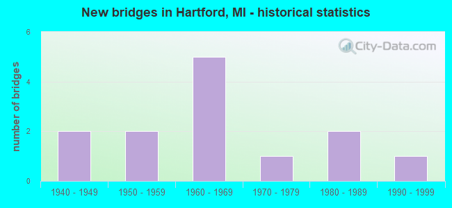
- New bridges - historical statistics
- 21940-1949
- 21950-1959
- 51960-1969
- 11970-1979
- 21980-1989
- 11990-1999

- Reconstructed bridges - Historical Statistics
- 22000-2009
- 12010-2019


- Bridge Condition - Deck
- 18.2%Very good
- 18.2%Good
- 54.5%Satisfactory
- 9.1%Fair

- Bridge Condition - Superstructure
- 18.2%Very good
- 18.2%Good
- 63.6%Satisfactory

- Bridge Condition - Substructure
- 18.2%Very good
- 63.6%Good
- 9.1%Satisfactory
- 9.1%Fair

- Bridge Condition - Channel
- 33.3%Good
- 44.4%Satisfactory
- 22.2%Fair
Find on map >> Show street view
Structure Number: 10697, Location: 2.7 MI E OF BERRIEN COL (Lat: 42.191803, Lng: -86.171103), Route carried "on" structure: Interstate 94, Year Built: 1960, Year Reconstructed: 2014, Status: Open, Structure Length: 0.93m (3.05ft), Average Daily Traffic: 16,700 (year 2014), Truck Traffic: 22%, Average Future Daily Traffic: 18,500 (year 2034), Design Load: HS 20+Mod, Features Intersected: PINE CREEK
Minimum Vertical Clearance: 30.48m (100.00ft), Kilometerpoint: 4.397, Lanes on structure: 3, Base Highway Network: Yes (Inventory Route: 58, Subroute: 5), Owner: State Highway Agency, Approaching Roadway Width: 11.6m (38.1ft), Skew: 2 degrees, Material/Design: Concrete, Design/Construction: Tee Beam, Number Of Spans In Main Unit: 1, Length of Maximum Span: 8.8m (28.9ft), Curb-To-Curb Width: 18.1m (59.4ft), Out-to-Out Width: 19.1m (62.7ft)
Condition: Deck: Satisfactory, Superstructure: Satisfactory, Substructure: Good, Channel: Fair, Operating Rating: 58.0 metric tons, Method Used To Determine Operating Rating: Load Factor (LF) rating reported by rating factor (RF) method using MS18 loading, Inventory Rating: 35.0 metric tons, Method Used To Determine Inventory Rating: Load Factor (LF) rating reported by rating factor (RF) method using MS18 loading, Structural Evaluation: Equal to present minimum criteria, Deck Geometry: Better than present minimum criteria, Waterway Adequacy: Equal to present desirable criteria, Approach Roadway Alignment: Equal to present desirable criteria, Designated Inspection Frequency: Every 24 months, Inspection Date: October 2021, Deck Structure Type: Concrete Cast-file-Place, Wearing Surface/Protective System: Wearing Surface: Latex Concrete
Find on map >> Show street view
Structure Number: 10698, Location: 2.7 MI E OF BERRIEN COL (Lat: 42.192058, Lng: -86.171292), Route carried "on" structure: Interstate 94, Year Built: 1960, Status: Open, Structure Length: 0.94m (3.08ft), Average Daily Traffic: 15,032 (year 2007), Truck Traffic: 27%, Average Future Daily Traffic: 21,368 (year 2018), Design Load: HS 20+Mod, Features Intersected: PINE CREEK
Minimum Vertical Clearance: 30.48m (100.00ft), Kilometerpoint: 4.382, Lanes on structure: 3, Base Highway Network: Yes (Inventory Route: 58, Subroute: 3), Owner: State Highway Agency, Approaching Roadway Width: 12.2m (40.0ft), Skew: 2 degrees, Material/Design: Concrete, Design/Construction: Tee Beam, Number Of Spans In Main Unit: 1, Length of Maximum Span: 9.4m (30.8ft), Curb-To-Curb Width: 16.6m (54.5ft), Out-to-Out Width: 18.2m (59.7ft)
Condition: Deck: Fair, Superstructure: Satisfactory, Substructure: Good, Channel: Fair, Operating Rating: 57.0 metric tons, Method Used To Determine Operating Rating: Load Factor (LF) rating reported by rating factor (RF) method using MS18 loading, Inventory Rating: 34.3 metric tons, Method Used To Determine Inventory Rating: Load Factor (LF) rating reported by rating factor (RF) method using MS18 loading, Structural Evaluation: Equal to present minimum criteria, Deck Geometry: Equal to present minimum criteria, Waterway Adequacy: Equal to present desirable criteria, Approach Roadway Alignment: Equal to present minimum criteria, Designated Inspection Frequency: Every 24 months, Inspection Date: October 2021, Deck Structure Type: Concrete Cast-file-Place, Wearing Surface/Protective System: Wearing Surface: Latex Concrete
Find on map >> Show street view
Structure Number: 10701, Location: 2.9 MI E OF BERRIEN COL (Lat: 42.192297, Lng: -86.166592), Route carried "on" structure: County highway 8029, Year Built: 1959, Status: Open, Structure Length: 7.82m (25.66ft), Average Daily Traffic: 5,450 (year 1997), Truck Traffic: 3%, Average Future Daily Traffic: 6,268 (year 2017), Design Load: HS 20+Mod, Features Intersected: I-94, Facility Carried by Structure: 64 TH ST (CR687)
Minimum Vertical Clearance: 30.48m (100.00ft), Kilometerpoint: 12.661, Lanes on structure: 2, Lanes under structure: 4, Owner: State Highway Agency, Approaching Roadway Width: 7.9m (25.9ft), Material/Design: Concrete continuous, Design/Construction: Tee Beam, Number Of Spans In Main Unit: 4, Length of Maximum Span: 22.3m (73.2ft), Curb-To-Curb Width: 8.9m (29.2ft), Out-to-Out Width: 10.2m (33.5ft)
Condition: Deck: Satisfactory, Superstructure: Satisfactory, Substructure: Good, Operating Rating: 69.3 metric tons, Method Used To Determine Operating Rating: Load Factor (LF) rating reported by rating factor (RF) method using MS18 loading, Inventory Rating: 41.5 metric tons, Method Used To Determine Inventory Rating: Load Factor (LF) rating reported by rating factor (RF) method using MS18 loading, Structural Evaluation: Equal to present minimum criteria, Deck Geometry: Meets minimum limits, Underclear: Meets minimum limits, Approach Roadway Alignment: Better than present minimum criteria, Designated Inspection Frequency: Every 24 months, Inspection Date: October 2021, Deck Structure Type: Concrete Cast-file-Place, Wearing Surface/Protective System: Wearing Surface: Latex Concrete
Find on map >> Show street view
Structure Number: 10702, Location: 4.0 MI E OF BERRIEN COL (Lat: 42.193550, Lng: -86.147156), Route carried "on" structure: County highway , Year Built: 1960, Status: Open, Structure Length: 6.90m (22.64ft), Average Daily Traffic: 720 (year 1997), Truck Traffic: 3%, Average Future Daily Traffic: 9,999 (year 1977), Design Load: H 15, Features Intersected: I-94, Facility Carried by Structure: 62 ND STREET
Minimum Vertical Clearance: 30.48m (100.00ft), Kilometerpoint: 15.614, Lanes on structure: 2, Lanes under structure: 4, Owner: State Highway Agency, Approaching Roadway Width: 7.9m (25.9ft), Material/Design: Concrete continuous, Design/Construction: Tee Beam, Number Of Spans In Main Unit: 4, Length of Maximum Span: 21.5m (70.5ft), Curb-To-Curb Width: 9.1m (29.9ft), Out-to-Out Width: 10.2m (33.5ft)
Condition: Deck: Satisfactory, Superstructure: Satisfactory, Substructure: Good, Operating Rating: 46.3 metric tons, Method Used To Determine Operating Rating: Load Factor (LF) rating reported by rating factor (RF) method using MS18 loading, Inventory Rating: 27.9 metric tons, Method Used To Determine Inventory Rating: Load Factor (LF) rating reported by rating factor (RF) method using MS18 loading, Structural Evaluation: Equal to present minimum criteria, Deck Geometry: Equal to present minimum criteria, Underclear: Meets minimum limits, Approach Roadway Alignment: Better than present minimum criteria, Designated Inspection Frequency: Every 24 months, Inspection Date: October 2021, Deck Structure Type: Concrete Cast-file-Place, Wearing Surface/Protective System: Wearing Surface: Latex Concrete
Find on map >> Show street view
Structure Number: 10737, Location: 0.25 MI WEST OF HARTFORD (Lat: 42.205811, Lng: -86.182039), Route carried "on" structure: County highway 8040, Year Built: 1940, Status: Open, Structure Length: 0.73m (2.40ft), Average Daily Traffic: 8,416 (year 2019), Truck Traffic: 1%, Average Future Daily Traffic: 9,298 (year 2039), Features Intersected: PINE RIVER, Facility Carried by Structure: RED ARROW HWY
Minimum Vertical Clearance: 30.48m (100.00ft), Kilometerpoint: 3.560, Lanes on structure: 2, Owner: County Highway Agency, Approaching Roadway Width: 13.4m (44.0ft), Material/Design: Concrete, Design/Construction: Tee Beam, Number Of Spans In Main Unit: 1, Length of Maximum Span: 7.3m (24.0ft), Curb-To-Curb Width: 13.7m (44.9ft), Out-to-Out Width: 18.3m (60.0ft)
Condition: Deck: Satisfactory, Superstructure: Satisfactory, Substructure: Satisfactory, Channel: Satisfactory, Operating Rating: 43.6 metric tons, Method Used To Determine Operating Rating: Field evaluation and documented engineering judgment, Inventory Rating: 32.7 metric tons, Method Used To Determine Inventory Rating: Field evaluation and documented engineering judgment, Structural Evaluation: Equal to present minimum criteria, Deck Geometry: Superior to present desirable criteria, Waterway Adequacy: Equal to present desirable criteria, Approach Roadway Alignment: Equal to present desirable criteria, Designated Inspection Frequency: Every 24 months, Inspection Date: May 2020, Deck Structure Type: Concrete Cast-file-Place, Wearing Surface/Protective System: Wearing Surface: Bituminous
Find on map >> Show street view
Structure Number: 10738, Location: 0.75 MI EAST OF HARTFORD (Lat: 42.208647, Lng: -86.142472), Route carried "on" structure: County highway 8040, Year Built: 1940, Status: Open, Structure Length: 0.67m (2.20ft), Average Daily Traffic: 5,915 (year 2019), Truck Traffic: 2%, Average Future Daily Traffic: 6,535 (year 2039), Features Intersected: TRIB TO PAW PAW RIVER, Facility Carried by Structure: RED ARROW HWY
Minimum Vertical Clearance: 30.48m (100.00ft), Kilometerpoint: 6.846, Lanes on structure: 2, Owner: County Highway Agency, Approaching Roadway Width: 12.2m (40.0ft), Material/Design: Concrete, Design/Construction: Tee Beam, Number Of Spans In Main Unit: 1, Length of Maximum Span: 6.1m (20.0ft), Curb-To-Curb Width: 12.8m (42.0ft), Out-to-Out Width: 20.1m (65.9ft)
Condition: Deck: Satisfactory, Superstructure: Satisfactory, Substructure: Good, Channel: Satisfactory, Operating Rating: 43.6 metric tons, Method Used To Determine Operating Rating: Field evaluation and documented engineering judgment, Inventory Rating: 32.7 metric tons, Method Used To Determine Inventory Rating: Field evaluation and documented engineering judgment, Structural Evaluation: Equal to present minimum criteria, Deck Geometry: Somewhat better than minimum adequacy, Waterway Adequacy: Equal to present desirable criteria, Approach Roadway Alignment: Equal to present desirable criteria, Designated Inspection Frequency: Every 24 months, Inspection Date: May 2020, Deck Structure Type: Concrete Cast-file-Place, Wearing Surface/Protective System: Wearing Surface: Bituminous
Find on map >> Show street view
Structure Number: 10745, Location: 0.5 MI N OF HARTFORD (Lat: 42.221383, Lng: -86.164983), Route carried "on" structure: County highway 8029, Year Built: 1981, Status: Open, Structure Length: 4.11m (13.48ft), Average Daily Traffic: 1,895 (year 2015), Truck Traffic: 2%, Average Future Daily Traffic: 2,312 (year 2035), Design Load: HS 20, Features Intersected: PAW PAW RIVER, Facility Carried by Structure: CR 687
Minimum Vertical Clearance: 30.48m (100.00ft), Kilometerpoint: 15.949, Lanes on structure: 2, Owner: County Highway Agency, Approaching Roadway Width: 11.0m (36.1ft), Skew: 3 degrees, Material/Design: Prestressed concrete, Design/Construction: Stringer/Multi-beam, Number Of Spans In Main Unit: 3, Length of Maximum Span: 13.7m (44.9ft), Curb-To-Curb Width: 13.4m (44.0ft), Out-to-Out Width: 14.0m (45.9ft)
Condition: Deck: Satisfactory, Superstructure: Satisfactory, Substructure: Good, Channel: Good, Operating Rating: 77.1 metric tons, Method Used To Determine Operating Rating: Load Factor (LF), Inventory Rating: 46.2 metric tons, Method Used To Determine Inventory Rating: Load Factor (LF), Structural Evaluation: Equal to present minimum criteria, Deck Geometry: Equal to present desirable criteria, Waterway Adequacy: Equal to present desirable criteria, Approach Roadway Alignment: Better than present minimum criteria, Designated Inspection Frequency: Every 24 months, Inspection Date: May 2020, Deck Structure Type: Concrete Cast-file-Place, Wearing Surface/Protective System: Wearing Surface: Epoxy Overlay, Deck Protection: Epoxy Coated Reinforcing
Find on map >> Show street view
Structure Number: 10772, Location: HARTFORD TWP SEC 27 (Lat: 42.178758, Lng: -86.157683), Route carried "on" structure: County highway , Year Built: 1992, Status: Open, Structure Length: 0.79m (2.59ft), Average Daily Traffic: 630 (year 2015), Truck Traffic: 2%, Average Future Daily Traffic: 769 (year 2035), Design Load: HS 20, Features Intersected: PINE CREEK, Facility Carried by Structure: 66TH AVENUE
Minimum Vertical Clearance: 30.48m (100.00ft), Kilometerpoint: 5.395, Lanes on structure: 2, Owner: County Highway Agency, Approaching Roadway Width: 9.1m (29.9ft), Material/Design: Prestressed concrete, Design/Construction: Channel Beam, Number Of Spans In Main Unit: 1, Length of Maximum Span: 7.6m (24.9ft), Curb-To-Curb Width: 8.6m (28.2ft), Out-to-Out Width: 8.8m (28.9ft)
Condition: Deck: Good, Superstructure: Good, Substructure: Good, Channel: Good, Operating Rating: 71.9 metric tons, Method Used To Determine Operating Rating: Load Factor (LF) rating reported by rating factor (RF) method using MS18 loading, Inventory Rating: 43.1 metric tons, Method Used To Determine Inventory Rating: Load Factor (LF) rating reported by rating factor (RF) method using MS18 loading, Structural Evaluation: Better than present minimum criteria, Deck Geometry: Somewhat better than minimum adequacy, Waterway Adequacy: Equal to present desirable criteria, Approach Roadway Alignment: Equal to present desirable criteria, Designated Inspection Frequency: Every 24 months, Inspection Date: May 2020, Deck Structure Type: Concrete Precast Panels, Wearing Surface/Protective System: Wearing Surface: Bituminous
Find on map >> Show street view
Structure Number: 10774, Location: 1.2 MI W OF HARTFORD (Lat: 42.217539, Lng: -86.199625), Route carried "on" structure: County highway , Year Built: 1964, Year Reconstructed: 2010, Status: Open, Structure Length: 2.68m (8.79ft), Average Daily Traffic: 1,030 (year 2010), Average Future Daily Traffic: 1,500 (year 2030), Design Load: HS 20, Features Intersected: PAW PAW RIVER, Facility Carried by Structure: PINERY ROAD
Minimum Vertical Clearance: 30.48m (100.00ft), Kilometerpoint: 0.304, Lanes on structure: 2, Owner: County Highway Agency, Approaching Roadway Width: 9.1m (29.9ft), Material/Design: Wood or Timber, Design/Construction: Slab, Number Of Spans In Main Unit: 4, Length of Maximum Span: 6.7m (22.0ft), Curb-To-Curb Width: 8.5m (27.9ft), Out-to-Out Width: 9.4m (30.8ft)
Condition: Deck: Very good, Superstructure: Very good, Substructure: Fair, Channel: Satisfactory, Operating Rating: 48.0 metric tons, Method Used To Determine Operating Rating: Load and Resistance Factor Rating (LRFR) rating reported by rating factor(RF) method using HL-93 loadings, Inventory Rating: 34.0 metric tons, Method Used To Determine Inventory Rating: Load and Resistance Factor Rating (LRFR) rating reported by rating factor(RF) method using HL-93 loadings, Structural Evaluation: Somewhat better than minimum adequacy, Deck Geometry: Somewhat better than minimum adequacy, Waterway Adequacy: Better than present minimum criteria, Approach Roadway Alignment: Better than present minimum criteria, Designated Inspection Frequency: Every 24 months, Inspection Date: May 2020, Deck Structure Type: Wood or Timber, Wearing Surface/Protective System: Wearing Surface: Bituminous
Find on map >> Show street view
Structure Number: 10775, Location: 1.0 MI N OF RED ARROW HWY (Lat: 42.227100, Lng: -86.123625), Route carried "on" structure: County highway , Year Built: 1974, Year Reconstructed: 2011, Status: Open, Structure Length: 3.66m (12.01ft), Average Daily Traffic: 708 (year 2010), Average Future Daily Traffic: 1,048 (year 2030), Design Load: Greater than HL93, Features Intersected: PAW PAW RIVER, Facility Carried by Structure: 5950 STREET
Minimum Vertical Clearance: 30.48m (100.00ft), Kilometerpoint: 1.613, Lanes on structure: 2, Owner: County Highway Agency, Approaching Roadway Width: 7.3m (24.0ft), Material/Design: Steel, Design/Construction: Stringer/Multi-beam, Number Of Spans In Main Unit: 3, Length of Maximum Span: 12.1m (39.7ft), Curb-To-Curb Width: 9.1m (29.9ft), Out-to-Out Width: 9.8m (32.2ft)
Condition: Deck: Very good, Superstructure: Very good, Substructure: Very good, Channel: Satisfactory, Operating Rating: 79.1 metric tons, Method Used To Determine Operating Rating: Load and Resistance Factor Rating (LRFR) rating reported by rating factor(RF) method using HL-93 loadings, Inventory Rating: 60.6 metric tons, Method Used To Determine Inventory Rating: Load and Resistance Factor Rating (LRFR) rating reported by rating factor(RF) method using HL-93 loadings, Structural Evaluation: Equal to present desirable criteria, Deck Geometry: Equal to present minimum criteria, Waterway Adequacy: Equal to present desirable criteria, Approach Roadway Alignment: Meets minimum limits, Designated Inspection Frequency: Every 24 months, Inspection Date: May 2020, Deck Structure Type: Concrete Cast-file-Place, Wearing Surface/Protective System: Wearing Surface: Monolithic Concrete, Deck Protection: Epoxy Coated Reinforcing
Find on map >> Show street view
Structure Number: 10776, Location: 0.8 MI W OF CR 681 (Lat: 42.227669, Lng: -86.120825), Route carried "on" structure: County highway , Year Built: 1982, Status: Open, Structure Length: 3.78m (12.40ft), Average Daily Traffic: 448 (year 2004), Average Future Daily Traffic: 659 (year 2024), Design Load: HS 20, Features Intersected: PAW PAW RIVER, Facility Carried by Structure: BUTCHER ROAD
Minimum Vertical Clearance: 30.48m (100.00ft), Kilometerpoint: 0.217, Lanes on structure: 2, Owner: County Highway Agency, Approaching Roadway Width: 11.0m (36.1ft), Material/Design: Prestressed concrete, Design/Construction: Box Beam or Girders - Multiple, Number Of Spans In Main Unit: 2, Length of Maximum Span: 18.9m (62.0ft), Curb-To-Curb Width: 9.1m (29.9ft), Out-to-Out Width: 9.3m (30.5ft)
Condition: Deck: Good, Superstructure: Good, Substructure: Very good, Channel: Good, Operating Rating: 64.0 metric tons, Method Used To Determine Operating Rating: Load Factor (LF), Inventory Rating: 38.3 metric tons, Method Used To Determine Inventory Rating: Load Factor (LF), Structural Evaluation: Better than present minimum criteria, Deck Geometry: Equal to present minimum criteria, Waterway Adequacy: Equal to present desirable criteria, Approach Roadway Alignment: Equal to present desirable criteria, Designated Inspection Frequency: Every 24 months, Inspection Date: May 2020, Deck Structure Type: Concrete Precast Panels, Wearing Surface/Protective System: Wearing Surface: Bituminous, Deck Protection: Epoxy Coated Reinforcing
Find on map >> Show street view
Structure Number: 10701, Location: 2.9 MI E OF BERRIEN COL (Lat: 42.192297, Lng: -86.166592), Route carried "under" structure: Interstate 94, Year Built: 1959, Structure Length: 0. m, Average Daily Traffic: 30,064 (year 2007), Truck Traffic: 31%, Features Intersected: I-94, Facility Carried by Structure: 64 TH ST (CR687)
Minimum Vertical Clearance: 4.93m (16.17ft), Kilometerpoint: 4.773, Lanes on structure: 2, Lanes under structure: 4, Material/Design: Concrete continuous, Design/Construction: Tee Beam, Length of Maximum Span: 22.3m (73.2ft)
Find on map >> Show street view
Structure Number: 10702, Location: 4.0 MI E OF BERRIEN COL (Lat: 42.193550, Lng: -86.147156), Route carried "under" structure: Interstate 94, Year Built: 1960, Structure Length: 0. m, Average Daily Traffic: 31,871 (year 2013), Truck Traffic: 22%, Features Intersected: I-94, Facility Carried by Structure: 62 ND STREET
Minimum Vertical Clearance: 5.36m (17.59ft), Kilometerpoint: 6.384, Lanes on structure: 2, Lanes under structure: 4, Material/Design: Concrete continuous, Design/Construction: Tee Beam, Length of Maximum Span: 21.5m (70.5ft)