Bridge Statistics for Hart, Michigan (MI)
Condition, Traffic, Stress, Structural Evaluation, Project Costs
- National Bridge Inventory (NBI) Statistics
- 24Number of bridges
- 207ft / 62.8mTotal length
- $629,000Total costs
- 86,842Total average daily traffic
- 6,906Total average daily truck traffic
- National Bridge Inventory (NBI) Registered Bridges for Hart
- No street view available for this location
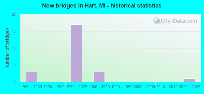
- New bridges - historical statistics
- 31950-1959
- 171970-1979
- 31980-1989
- 12020-2022

- Reconstructed bridges - Historical Statistics
- 11980-1989
- 01990-1999
- 12000-2009


- Bridge Condition - Deck
- 30.8%Good
- 61.5%Satisfactory
- 7.7%Fair

- Bridge Condition - Superstructure
- 38.5%Good
- 30.8%Satisfactory
- 30.8%Fair

- Bridge Condition - Substructure
- 7.7%Very good
- 46.2%Good
- 30.8%Satisfactory
- 15.4%Fair

- Bridge Condition - Channel
- 11.1%Excellent
- 11.1%Very good
- 33.3%Good
- 11.1%Satisfactory
- 33.3%Fair

- Bridge Condition - Culverts
- 33.3%Excellent
- 33.3%Satisfactory
- 33.3%Poor
Find on map >> Show street view
Structure Number: 8318, Location: N LTS OF HART (Lat: 43.707442, Lng: -86.355944), Route carried "on" structure: ServiceUS 31, Year Built: 1954, Year Reconstructed: 2008, Status: Open, Structure Length: 8.23m (27.00ft), Average Daily Traffic: 4,200 (year 2019), Truck Traffic: 3%, Average Future Daily Traffic: 4,650 (year 2040), Design Load: HS 20, Features Intersected: PENTWATER RIVER
Minimum Vertical Clearance: 30.48m (100.00ft), Kilometerpoint: 27.471, Lanes on structure: 2, Owner: State Highway Agency, Approaching Roadway Width: 10.4m (34.1ft), Skew: 20 degrees, Material/Design: Steel, Design/Construction: Girder and Floorbeam System, Number Of Spans In Main Unit: 3, Length of Maximum Span: 31.1m (102.0ft), Curb-To-Curb Width: 17.0m (55.8ft), Out-to-Out Width: 19.2m (63.0ft)
Condition: Deck: Satisfactory, Superstructure: Satisfactory, Substructure: Good, Channel: Fair, Operating Rating: 61.2 metric tons, Method Used To Determine Operating Rating: Load Factor (LF) rating reported by rating factor (RF) method using MS18 loading, Inventory Rating: 36.6 metric tons, Method Used To Determine Inventory Rating: Load Factor (LF) rating reported by rating factor (RF) method using MS18 loading, Structural Evaluation: Equal to present minimum criteria, Deck Geometry: Superior to present desirable criteria, Waterway Adequacy: Better than present minimum criteria, Approach Roadway Alignment: Equal to present minimum criteria, Designated Inspection Frequency: Every 24 months, Critical Feature Inspection Frequency: Every 15 months, Inspection Date: November 2021, Critical Feature Inspection Date: July 2021, Deck Structure Type: Concrete Cast-file-Place, Wearing Surface/Protective System: Wearing Surface: Latex Concrete
Find on map >> Show street view
Structure Number: 8334, Location: 3 MI NW OF HART (Lat: 43.741536, Lng: -86.389894), Route carried "on" structure: US 31, Year Built: 1977, Year Reconstructed: 1987, Status: Open, Structure Length: 6.46m (21.19ft), Average Daily Traffic: 4,171 (year 2007), Truck Traffic: 11%, Average Future Daily Traffic: 5,668 (year 2018), Design Load: HS 25 or greater, Features Intersected: S BRANCH PENTWATER RIVER
Minimum Vertical Clearance: 30.48m (100.00ft), Kilometerpoint: 32.441, Lanes on structure: 2, Base Highway Network: Yes (Inventory Route: 154, Subroute: 2), Owner: State Highway Agency, Approaching Roadway Width: 12.8m (42.0ft), Material/Design: Steel, Design/Construction: Stringer/Multi-beam, Number Of Spans In Main Unit: 3, Length of Maximum Span: 28.9m (94.8ft), Curb-To-Curb Width: 12.5m (41.0ft), Out-to-Out Width: 13.4m (44.0ft)
Condition: Deck: Satisfactory, Superstructure: Fair, Substructure: Satisfactory, Channel: Good, Operating Rating: 71.9 metric tons, Method Used To Determine Operating Rating: Load Factor (LF) rating reported by rating factor (RF) method using MS18 loading, Inventory Rating: 43.1 metric tons, Method Used To Determine Inventory Rating: Load Factor (LF) rating reported by rating factor (RF) method using MS18 loading, Structural Evaluation: Somewhat better than minimum adequacy, Deck Geometry: Better than present minimum criteria, Waterway Adequacy: Equal to present desirable criteria, Approach Roadway Alignment: Equal to present desirable criteria, Designated Inspection Frequency: Every 24 months, Inspection Date: November 2021, Bridge Improvement Cost: $210,000, Deck Structure Type: Concrete Cast-file-Place, Wearing Surface/Protective System: Wearing Surface: Latex Concrete, Deck Protection: Epoxy Coated Reinforcing
Find on map >> Show street view
Structure Number: 8335, Location: 3 MI NW OF HART (Lat: 43.741475, Lng: -86.389272), Route carried "on" structure: US 31, Year Built: 1977, Status: Open, Structure Length: 6.40m (21.00ft), Average Daily Traffic: 4,171 (year 2007), Truck Traffic: 11%, Average Future Daily Traffic: 5,668 (year 2018), Design Load: HS 25 or greater, Features Intersected: S BRANCH PENTWATER RIVER
Minimum Vertical Clearance: 30.48m (100.00ft), Kilometerpoint: 32.378, Lanes on structure: 2, Base Highway Network: Yes (Inventory Route: 154, Subroute: 3), Owner: State Highway Agency, Approaching Roadway Width: 12.8m (42.0ft), Skew: 2 degrees, Material/Design: Steel, Design/Construction: Stringer/Multi-beam, Number Of Spans In Main Unit: 3, Length of Maximum Span: 28.9m (94.8ft), Curb-To-Curb Width: 12.5m (41.0ft), Out-to-Out Width: 13.4m (44.0ft)
Condition: Deck: Fair, Superstructure: Fair, Substructure: Good, Channel: Good, Operating Rating: 88.1 metric tons, Method Used To Determine Operating Rating: Load Factor (LF), Inventory Rating: 52.7 metric tons, Method Used To Determine Inventory Rating: Load Factor (LF), Structural Evaluation: Somewhat better than minimum adequacy, Deck Geometry: Better than present minimum criteria, Waterway Adequacy: Equal to present desirable criteria, Approach Roadway Alignment: Equal to present desirable criteria, Designated Inspection Frequency: Every 24 months, Inspection Date: November 2021, Bridge Improvement Cost: $212,000, Roadway Improvement Cost: $16,000, Total Project Cost: $188,000, Deck Structure Type: Concrete Cast-file-Place, Wearing Surface/Protective System: Wearing Surface: Monolithic Concrete
Find on map >> Show street view
Structure Number: 8341, Location: 1.5 MI W OF HART (Lat: 43.682850, Lng: -86.393472), Route carried "on" structure: US 31, Year Built: 1975, Status: Open, Structure Length: 5.00m (16.40ft), Average Daily Traffic: 4,806 (year 2007), Truck Traffic: 10%, Average Future Daily Traffic: 7,122 (year 2018), Design Load: HS 25 or greater, Features Intersected: LOG RD & CSX RR (ABN)
Minimum Vertical Clearance: 30.48m (100.00ft), Kilometerpoint: 25.768, Lanes on structure: 3, Lanes under structure: 2, Base Highway Network: Yes (Inventory Route: 154, Subroute: 2), Owner: State Highway Agency, Approaching Roadway Width: 16.8m (55.1ft), Skew: 3 degrees, Material/Design: Prestressed concrete, Design/Construction: Stringer/Multi-beam, Number Of Spans In Main Unit: 3, Length of Maximum Span: 16.7m (54.8ft), Curb-To-Curb Width: 16.2m (53.1ft), Out-to-Out Width: 16.6m (54.5ft)
Condition: Deck: Satisfactory, Superstructure: Fair, Substructure: Satisfactory, Operating Rating: 49.6 metric tons, Method Used To Determine Operating Rating: Load Factor (LF) rating reported by rating factor (RF) method using MS18 loading, Inventory Rating: 29.5 metric tons, Method Used To Determine Inventory Rating: Load Factor (LF) rating reported by rating factor (RF) method using MS18 loading, Structural Evaluation: Somewhat better than minimum adequacy, Deck Geometry: Better than present minimum criteria, Underclear: Equal to present desirable criteria, Approach Roadway Alignment: Equal to present desirable criteria, Designated Inspection Frequency: Every 24 months, Inspection Date: April 2020, Deck Structure Type: Concrete Cast-file-Place, Wearing Surface/Protective System: Wearing Surface: Monolithic Concrete
Find on map >> Show street view
Structure Number: 8343, Location: 1.5 MI W OF HART (Lat: 43.683011, Lng: -86.392875), Route carried "on" structure: US 31, Year Built: 1975, Status: Open, Structure Length: 5.00m (16.40ft), Average Daily Traffic: 4,806 (year 2007), Truck Traffic: 10%, Average Future Daily Traffic: 7,122 (year 2018), Design Load: HS 25 or greater, Features Intersected: LOG RD & CSX RR (ABN)
Minimum Vertical Clearance: 30.48m (100.00ft), Kilometerpoint: 25.734, Lanes on structure: 3, Lanes under structure: 2, Base Highway Network: Yes (Inventory Route: 154, Subroute: 3), Owner: State Highway Agency, Approaching Roadway Width: 16.8m (55.1ft), Skew: 3 degrees, Material/Design: Prestressed concrete, Design/Construction: Stringer/Multi-beam, Number Of Spans In Main Unit: 3, Length of Maximum Span: 16.7m (54.8ft), Curb-To-Curb Width: 16.2m (53.1ft), Out-to-Out Width: 16.6m (54.5ft)
Condition: Deck: Satisfactory, Superstructure: Fair, Substructure: Fair, Operating Rating: 57.0 metric tons, Method Used To Determine Operating Rating: Load Factor (LF) rating reported by rating factor (RF) method using MS18 loading, Inventory Rating: 34.3 metric tons, Method Used To Determine Inventory Rating: Load Factor (LF) rating reported by rating factor (RF) method using MS18 loading, Structural Evaluation: Somewhat better than minimum adequacy, Deck Geometry: Better than present minimum criteria, Underclear: Equal to present minimum criteria, Approach Roadway Alignment: Equal to present desirable criteria, Designated Inspection Frequency: Every 24 months, Inspection Date: April 2020, Deck Structure Type: Concrete Cast-file-Place, Wearing Surface/Protective System: Wearing Surface: Monolithic Concrete
Find on map >> Show street view
Structure Number: 835, Location: 2 MI SW OF HART (Lat: 43.674822, Lng: -86.395208), Route carried "on" structure: County highway , Year Built: 1976, Status: Open, Structure Length: 10.09m (33.10ft), Average Daily Traffic: 120 (year 1988), Average Future Daily Traffic: 100 (year 1977), Design Load: H 20, Features Intersected: US-31, Facility Carried by Structure: TAYLOR ROAD
Minimum Vertical Clearance: 30.48m (100.00ft), Kilometerpoint: 5.211, Lanes on structure: 2, Lanes under structure: 4, Owner: State Highway Agency, Approaching Roadway Width: 10.9m (35.8ft), Skew: 1 degrees, Material/Design: Steel, Design/Construction: Stringer/Multi-beam, Number Of Spans In Main Unit: 5, Length of Maximum Span: 28.3m (92.8ft), Curb or Sidewalk Widths: Left: 0.2m (0.7ft), Right: 0.2m (0.7ft), Curb-To-Curb Width: 11.5m (37.7ft), Out-to-Out Width: 12.3m (40.4ft)
Condition: Deck: Good, Superstructure: Good, Substructure: Good, Operating Rating: 61.8 metric tons, Method Used To Determine Operating Rating: Load Factor (LF), Inventory Rating: 37.1 metric tons, Method Used To Determine Inventory Rating: Load Factor (LF), Structural Evaluation: Better than present minimum criteria, Deck Geometry: Superior to present desirable criteria, Underclear: Superior to present desirable criteria, Approach Roadway Alignment: Equal to present desirable criteria, Designated Inspection Frequency: Every 24 months, Inspection Date: November 2021, Bridge Improvement Cost: $327,000, Roadway Improvement Cost: $25,000, Total Project Cost: $289,000, Deck Structure Type: Concrete Cast-file-Place, Wearing Surface/Protective System: Wearing Surface: Monolithic Concrete
Find on map >> Show street view
Structure Number: 8351, Location: 1.5 MI W OF HART (Lat: 43.689161, Lng: -86.392164), Route carried "on" structure: US 31, Year Built: 1975, Status: Open, Structure Length: 2.92m (9.58ft), Average Daily Traffic: 4,806 (year 2007), Truck Traffic: 11%, Average Future Daily Traffic: 5,668 (year 2018), Design Load: HS 25 or greater, Features Intersected: US-31 BR POLK RD
Minimum Vertical Clearance: 30.48m (100.00ft), Kilometerpoint: 26.420, Lanes on structure: 2, Lanes under structure: 2, Base Highway Network: Yes (Inventory Route: 154, Subroute: 3), Owner: State Highway Agency, Approaching Roadway Width: 13.4m (44.0ft), Material/Design: Steel, Design/Construction: Stringer/Multi-beam, Number Of Spans In Main Unit: 1, Length of Maximum Span: 29.2m (95.8ft), Curb-To-Curb Width: 13.0m (42.7ft), Out-to-Out Width: 13.5m (44.3ft)
Condition: Deck: Satisfactory, Superstructure: Good, Substructure: Fair, Operating Rating: 97.4 metric tons, Method Used To Determine Operating Rating: Load Factor (LF), Inventory Rating: 58.3 metric tons, Method Used To Determine Inventory Rating: Load Factor (LF), Structural Evaluation: Somewhat better than minimum adequacy, Deck Geometry: Superior to present desirable criteria, Underclear: Equal to present minimum criteria, Approach Roadway Alignment: Equal to present desirable criteria, Length Of Structure Improvement: 2.93m (9.61ft), Designated Inspection Frequency: Every 24 months, Inspection Date: November 2021, Bridge Improvement Cost: $64,000, Roadway Improvement Cost: $4,000, Total Project Cost: $41,000, Deck Structure Type: Concrete Cast-file-Place, Wearing Surface/Protective System: Wearing Surface: Monolithic Concrete
Find on map >> Show street view
Structure Number: 8353, Location: 2.5 MILES NW OF HART (Lat: 43.733967, Lng: -86.394819), Route carried "on" structure: US 31, Year Built: 1977, Status: Open, Structure Length: 2.83m (9.28ft), Average Daily Traffic: 4,171 (year 2007), Truck Traffic: 11%, Average Future Daily Traffic: 5,668 (year 2018), Design Load: HS 25 or greater, Features Intersected: WAYNE ROAD
Minimum Vertical Clearance: 30.48m (100.00ft), Kilometerpoint: 31.512, Lanes on structure: 2, Lanes under structure: 2, Base Highway Network: Yes (Inventory Route: 154, Subroute: 2), Owner: State Highway Agency, Approaching Roadway Width: 12.8m (42.0ft), Material/Design: Steel, Design/Construction: Stringer/Multi-beam, Number Of Spans In Main Unit: 1, Length of Maximum Span: 28.3m (92.8ft), Curb-To-Curb Width: 12.6m (41.3ft), Out-to-Out Width: 13.4m (44.0ft)
Condition: Deck: Good, Superstructure: Good, Substructure: Good, Operating Rating: 88.5 metric tons, Method Used To Determine Operating Rating: Load Factor (LF) rating reported by rating factor (RF) method using MS18 loading, Inventory Rating: 53.1 metric tons, Method Used To Determine Inventory Rating: Load Factor (LF) rating reported by rating factor (RF) method using MS18 loading, Structural Evaluation: Better than present minimum criteria, Deck Geometry: Better than present minimum criteria, Underclear: Somewhat better than minimum adequacy, Approach Roadway Alignment: Equal to present desirable criteria, Length Of Structure Improvement: 2.84m (9.32ft), Designated Inspection Frequency: Every 24 months, Inspection Date: November 2021, Bridge Improvement Cost: $49,000, Roadway Improvement Cost: $3,000, Total Project Cost: $35,000, Deck Structure Type: Concrete Cast-file-Place, Wearing Surface/Protective System: Wearing Surface: Latex Concrete
Find on map >> Show street view
Structure Number: 8354, Location: 2.5 MILES NW OF HART (Lat: 43.733747, Lng: -86.394308), Route carried "on" structure: US 31, Year Built: 1977, Status: Open, Structure Length: 2.83m (9.28ft), Average Daily Traffic: 4,171 (year 2007), Truck Traffic: 11%, Average Future Daily Traffic: 5,668 (year 2018), Design Load: HS 25 or greater, Features Intersected: WAYNE ROAD
Minimum Vertical Clearance: 30.48m (100.00ft), Kilometerpoint: 31.428, Lanes on structure: 2, Lanes under structure: 2, Base Highway Network: Yes (Inventory Route: 154, Subroute: 3), Owner: State Highway Agency, Approaching Roadway Width: 12.8m (42.0ft), Material/Design: Steel, Design/Construction: Stringer/Multi-beam, Number Of Spans In Main Unit: 1, Length of Maximum Span: 28.3m (92.8ft), Curb-To-Curb Width: 12.6m (41.3ft), Out-to-Out Width: 13.4m (44.0ft)
Condition: Deck: Good, Superstructure: Satisfactory, Substructure: Good, Operating Rating: 88.1 metric tons, Method Used To Determine Operating Rating: Load Factor (LF) rating reported by rating factor (RF) method using MS18 loading, Inventory Rating: 52.8 metric tons, Method Used To Determine Inventory Rating: Load Factor (LF) rating reported by rating factor (RF) method using MS18 loading, Structural Evaluation: Equal to present minimum criteria, Deck Geometry: Better than present minimum criteria, Underclear: Somewhat better than minimum adequacy, Approach Roadway Alignment: Equal to present desirable criteria, Length Of Structure Improvement: 2.84m (9.32ft), Designated Inspection Frequency: Every 24 months, Inspection Date: November 2021, Bridge Improvement Cost: $49,000, Roadway Improvement Cost: $3,000, Total Project Cost: $35,000, Deck Structure Type: Concrete Cast-file-Place, Wearing Surface/Protective System: Wearing Surface: Monolithic Concrete, Deck Protection: Epoxy Coated Reinforcing
Find on map >> Show street view
Structure Number: 8359, Location: 1.5 MI W OF HART (Lat: 43.689175, Lng: -86.392656), Route carried "on" structure: US 31, Year Built: 1975, Status: Open, Structure Length: 2.92m (9.58ft), Average Daily Traffic: 4,806 (year 2007), Truck Traffic: 11%, Average Future Daily Traffic: 5,668 (year 2018), Design Load: HS 25 or greater, Features Intersected: US-31 BR POLK RD
Minimum Vertical Clearance: 30.48m (100.00ft), Kilometerpoint: 26.475, Lanes on structure: 2, Lanes under structure: 2, Base Highway Network: Yes (Inventory Route: 154, Subroute: 2), Owner: State Highway Agency, Approaching Roadway Width: 13.7m (44.9ft), Material/Design: Steel, Design/Construction: Stringer/Multi-beam, Number Of Spans In Main Unit: 1, Length of Maximum Span: 29.2m (95.8ft), Curb-To-Curb Width: 13.0m (42.7ft), Out-to-Out Width: 13.5m (44.3ft)
Condition: Deck: Satisfactory, Superstructure: Good, Substructure: Satisfactory, Operating Rating: 85.5 metric tons, Method Used To Determine Operating Rating: Load Factor (LF) rating reported by rating factor (RF) method using MS18 loading, Inventory Rating: 51.2 metric tons, Method Used To Determine Inventory Rating: Load Factor (LF) rating reported by rating factor (RF) method using MS18 loading, Structural Evaluation: Equal to present minimum criteria, Deck Geometry: Superior to present desirable criteria, Underclear: Equal to present minimum criteria, Approach Roadway Alignment: Equal to present desirable criteria, Length Of Structure Improvement: 2.93m (9.61ft), Designated Inspection Frequency: Every 24 months, Inspection Date: November 2021, Bridge Improvement Cost: $64,000, Roadway Improvement Cost: $4,000, Total Project Cost: $41,000, Deck Structure Type: Concrete Cast-file-Place, Wearing Surface/Protective System: Wearing Surface: Monolithic Concrete
Find on map >> Show street view
Structure Number: 8361, Location: 0.3 MI E OF US-31 (Lat: 43.689064, Lng: -86.387286), Route carried "on" structure: Business US 31, Year Built: 2020, Status: Open, Structure Length: 0.64m (2.10ft), Average Daily Traffic: 8,800 (year 2020), Truck Traffic: 4%, Average Future Daily Traffic: 9,725 (year 2040), Design Load: Greater than HL93, Features Intersected: RUSSELL CREEK
Minimum Vertical Clearance: 30.48m (100.00ft), Kilometerpoint: 2.511, Lanes on structure: 3, Owner: State Highway Agency, Approaching Roadway Width: 16.7m (54.8ft), Skew: 1 degrees, Material/Design: Aluminum, Iron, Design/Construction: Culvert, Number Of Spans In Main Unit: 1, Length of Maximum Span: 6.4m (21.0ft)
Condition: Channel: Excellent, Culverts: Excellent, Operating Rating: 97.2 metric tons, Method Used To Determine Operating Rating: Load and Resistance Factor Rating (LRFR) rating reported by rating factor(RF) method using HL-93 loadings, Inventory Rating: 97.2 metric tons, Method Used To Determine Inventory Rating: Load and Resistance Factor Rating (LRFR) rating reported by rating factor(RF) method using HL-93 loadings, Structural Evaluation: Superior to present desirable criteria, Waterway Adequacy: Superior to present desirable criteria, Approach Roadway Alignment: Equal to present desirable criteria, Designated Inspection Frequency: Every 22 months, Inspection Date: October 2020, Wearing Surface/Protective System: Wearing Surface: Bituminous
Find on map >> Show street view
Structure Number: 8369, Location: 2.8 MI E OF HART (Lat: 43.687183, Lng: -86.300311), Route carried "on" structure: County highway 6456, Year Built: 1982, Status: Open, Structure Length: 1.51m (4.95ft), Average Daily Traffic: 1,400 (year 2004), Average Future Daily Traffic: 2,000 (year 2024), Design Load: HS 20, Features Intersected: HUFTILE CREEK, Facility Carried by Structure: POLK ROAD
Minimum Vertical Clearance: 30.48m (100.00ft), Kilometerpoint: 9.524, Lanes on structure: 2, Owner: County Highway Agency, Approaching Roadway Width: 7.8m (25.6ft), Material/Design: Prestressed concrete, Design/Construction: Box Beam or Girders - Multiple, Number Of Spans In Main Unit: 1, Length of Maximum Span: 14.6m (47.9ft), Curb-To-Curb Width: 10.4m (34.1ft), Out-to-Out Width: 10.5m (34.4ft)
Condition: Deck: Satisfactory, Superstructure: Satisfactory, Substructure: Very good, Channel: Very good, Operating Rating: 59.6 metric tons, Method Used To Determine Operating Rating: Load Factor (LF) rating reported by rating factor (RF) method using MS18 loading, Inventory Rating: 35.6 metric tons, Method Used To Determine Inventory Rating: Load Factor (LF) rating reported by rating factor (RF) method using MS18 loading, Structural Evaluation: Equal to present minimum criteria, Deck Geometry: Equal to present minimum criteria, Waterway Adequacy: Better than present minimum criteria, Approach Roadway Alignment: Equal to present desirable criteria, Designated Inspection Frequency: Every 24 months, Inspection Date: August 2020, Deck Structure Type: Concrete Cast-file-Place, Wearing Surface/Protective System: Wearing Surface: Bituminous, Membrane: Preformed Fabric, Deck Protection: Epoxy Coated Reinforcing
Find on map >> Show street view
Structure Number: 8394, Location: 0.4 MI N OF HARRISON RD (Lat: 43.724275, Lng: -86.376772), Route carried "on" structure: County highway , Year Built: 1988, Status: Open, Structure Length: 1.95m (6.40ft), Average Daily Traffic: 1,900 (year 2004), Truck Traffic: 5%, Average Future Daily Traffic: 2,100 (year 2024), Design Load: HS 20, Features Intersected: S BR PENTWATER RIVER, Facility Carried by Structure: 72 ND AVE
Minimum Vertical Clearance: 30.48m (100.00ft), Kilometerpoint: 7.450, Lanes on structure: 2, Owner: County Highway Agency, Approaching Roadway Width: 9.8m (32.2ft), Material/Design: Prestressed concrete, Design/Construction: Box Beam or Girders - Multiple, Number Of Spans In Main Unit: 1, Length of Maximum Span: 18.9m (62.0ft), Curb-To-Curb Width: 11.4m (37.4ft), Out-to-Out Width: 11.4m (37.4ft)
Condition: Deck: Good, Superstructure: Good, Substructure: Good, Channel: Satisfactory, Operating Rating: 58.6 metric tons, Method Used To Determine Operating Rating: Load Factor (LF) rating reported by rating factor (RF) method using MS18 loading, Inventory Rating: 35.0 metric tons, Method Used To Determine Inventory Rating: Load Factor (LF) rating reported by rating factor (RF) method using MS18 loading, Structural Evaluation: Better than present minimum criteria, Deck Geometry: Equal to present minimum criteria, Waterway Adequacy: Better than present minimum criteria, Approach Roadway Alignment: Somewhat better than minimum adequacy, Designated Inspection Frequency: Every 24 months, Inspection Date: August 2020, Deck Structure Type: Concrete Precast Panels, Wearing Surface/Protective System: Wearing Surface: Bituminous, Membrane: Preformed Fabric
Find on map >> Show street view
Structure Number: 8395, Location: 0.25 MILE S OF LEVER RD (Lat: 43.720578, Lng: -86.297942), Route carried "on" structure: County highway , Year Built: 1950, Status: Open, Structure Length: 1.25m (4.10ft), Average Daily Traffic: 150 (year 2005), Truck Traffic: 5%, Average Future Daily Traffic: 250 (year 2025), Design Load: H 20, Features Intersected: S BRANCH PENTWATER RIVER, Facility Carried by Structure: 104TH AVE
Minimum Vertical Clearance: 30.48m (100.00ft), Kilometerpoint: 3.713, Lanes on structure: 2, Owner: County Highway Agency, Approaching Roadway Width: 6.7m (22.0ft), Material/Design: Steel, Design/Construction: Culvert, Number Of Spans In Main Unit: 6, Length of Maximum Span: 1.8m (5.9ft), Curb-To-Curb Width: 8.0m (26.2ft), Out-to-Out Width: 9.1m (29.9ft)
Condition: Channel: Fair, Culverts: Poor, Operating Rating: 97.2 metric tons, Method Used To Determine Operating Rating: Load Factor (LF) rating reported by rating factor (RF) method using MS18 loading, Inventory Rating: 97.2 metric tons, Method Used To Determine Inventory Rating: Load Factor (LF) rating reported by rating factor (RF) method using MS18 loading, Structural Evaluation: Meets minimum limits, Deck Geometry: Somewhat better than minimum adequacy, Waterway Adequacy: Better than present minimum criteria, Approach Roadway Alignment: Equal to present desirable criteria, Designated Inspection Frequency: Every 24 months, Inspection Date: August 2020
Find on map >> Show street view
Structure Number: 8409, Location: IN HART 350 FT N OF MAIN (Lat: 43.704247, Lng: -86.363428), Route carried "on" structure: Business City street , Year Built: 1983, Status: Posted for load, Structure Length: 3.59m (11.78ft), Average Daily Traffic: 1,350 (year 2004), Truck Traffic: 7%, Average Future Daily Traffic: 1,777 (year 2024), Design Load: HS 20+Mod, Features Intersected: HART LAKE-PENTWATER RIVE, Facility Carried by Structure: STATE STREET
Minimum Vertical Clearance: 30.48m (100.00ft), Kilometerpoint: 7.336, Lanes on structure: 2, Owner: City or Municipal Highway Agency, Approaching Roadway Width: 10.4m (34.1ft), Material/Design: Prestressed concrete, Design/Construction: Box Beam or Girders - Multiple, Number Of Spans In Main Unit: 2, Length of Maximum Span: 17.9m (58.7ft), Curb or Sidewalk Widths: Left: 1.5m (4.9ft), Right: 1.5m (4.9ft), Curb-To-Curb Width: 7.9m (25.9ft), Out-to-Out Width: 11.7m (38.4ft)
Condition: Deck: Satisfactory, Superstructure: Satisfactory, Substructure: Satisfactory, Channel: Good, Operating Rating: 58.6 metric tons, Method Used To Determine Operating Rating: Load Factor (LF) rating reported by rating factor (RF) method using MS18 loading, Inventory Rating: 34.0 metric tons, Method Used To Determine Inventory Rating: Load Factor (LF) rating reported by rating factor (RF) method using MS18 loading, Structural Evaluation: Equal to present minimum criteria, Deck Geometry: Meets minimum limits, Waterway Adequacy: Better than present minimum criteria, Approach Roadway Alignment: Equal to present desirable criteria, Bridge Posting: Required (Relationship of Operating Rating to Maximum Legal Load: > 39.9% below), Designated Inspection Frequency: Every 24 months, Underwater Inspection Frequency: Every 60 months, Inspection Date: July 2020, Underwater Inspection Date: November 2020, Deck Structure Type: Concrete Precast Panels, Wearing Surface/Protective System: Wearing Surface: Bituminous, Membrane: Preformed Fabric, Deck Protection: Epoxy Coated Reinforcing
Find on map >> Show street view
Structure Number: 13334, Location: 0.924 M E OF 88TH (Lat: 43.702131, Lng: -86.319475), Route carried "on" structure: County highway , Year Built: 1958, Status: Open, Structure Length: 1.16m (3.81ft), Average Daily Traffic: 2,150 (year 2004), Average Future Daily Traffic: 2,473 (year 2024), Features Intersected: HUFTILE CREEK, Facility Carried by Structure: TYLER ROAD
Minimum Vertical Clearance: 30.48m (100.00ft), Kilometerpoint: 3.589, Lanes on structure: 2, Owner: County Highway Agency, Approaching Roadway Width: 9.1m (29.9ft), Material/Design: Steel, Design/Construction: Culvert, Number Of Spans In Main Unit: 3, Length of Maximum Span: 3.0m (9.8ft)
Condition: Channel: Fair, Culverts: Satisfactory, Operating Rating: 97.2 metric tons, Method Used To Determine Operating Rating: Load Factor (LF) rating reported by rating factor (RF) method using MS18 loading, Inventory Rating: 97.2 metric tons, Method Used To Determine Inventory Rating: Load Factor (LF) rating reported by rating factor (RF) method using MS18 loading, Structural Evaluation: Equal to present minimum criteria, Waterway Adequacy: Better than present minimum criteria, Approach Roadway Alignment: Equal to present desirable criteria, Designated Inspection Frequency: Every 24 months, Inspection Date: August 2020, Wearing Surface/Protective System: Wearing Surface: Bituminous
Find on map >> Show street view
Structure Number: 8341, Location: 1.5 MI W OF HART (Lat: 43.682850, Lng: -86.393472), Route carried "under" structure: County highway , Year Built: 1975, Structure Length: 0. m, Average Daily Traffic: 75 (year 1988), Features Intersected: LOG RD & CSX RR (ABN), Facility Carried by Structure: US-31 SB
Minimum Vertical Clearance: 7.26m (23.82ft), Kilometerpoint: 27.513, Lanes on structure: 3, Lanes under structure: 2, Material/Design: Prestressed concrete, Design/Construction: Stringer/Multi-beam, Length of Maximum Span: 16.7m (54.8ft)
Find on map >> Show street view
Structure Number: 8343, Location: 1.5 MI W OF HART (Lat: 43.683011, Lng: -86.392875), Route carried "under" structure: County highway , Year Built: 1975, Structure Length: 0. m, Average Daily Traffic: 75 (year 1988), Features Intersected: LOG RD & CSX RR (ABN), Facility Carried by Structure: US-31 NB
Minimum Vertical Clearance: 30+ m (98+ ft), Kilometerpoint: 27.564, Lanes on structure: 3, Lanes under structure: 2, Material/Design: Prestressed concrete, Design/Construction: Stringer/Multi-beam, Length of Maximum Span: 16.7m (54.8ft)
Find on map >> Show street view
Structure Number: 835, Location: 2 MI SW OF HART (Lat: 43.674822, Lng: -86.395208), Route carried "under" structure: US 31, Year Built: 1976, Structure Length: 0. m, Average Daily Traffic: 9,612 (year 2007), Truck Traffic: 10%, Features Intersected: US-31, Facility Carried by Structure: TAYLOR ROAD
Minimum Vertical Clearance: 5.39m (17.68ft), Kilometerpoint: 24.804, Lanes on structure: 2, Lanes under structure: 4, Material/Design: Steel, Design/Construction: Stringer/Multi-beam, Length of Maximum Span: 28.3m (92.8ft)
Find on map >> Show street view
Structure Number: 8351, Location: 1.5 MI W OF HART (Lat: 43.689161, Lng: -86.392164), Route carried "under" structure: Business US 31, Year Built: 1975, Structure Length: 0. m, Average Daily Traffic: 6,330 (year 2007), Truck Traffic: 4%, Features Intersected: US-31 BR POLK RD
Minimum Vertical Clearance: 4.44m (14.57ft), Kilometerpoint: 2.118, Lanes on structure: 2, Lanes under structure: 2, Material/Design: Steel, Design/Construction: Stringer/Multi-beam, Length of Maximum Span: 29.2m (95.8ft)
Find on map >> Show street view
Structure Number: 8352, Location: 1.0 MI W OF HART (Lat: 43.703775, Lng: -86.392817), Route carried "under" structure: US 31, Year Built: 1976, Structure Length: 0. m, Average Daily Traffic: 8,342 (year 2007), Truck Traffic: 11%, Features Intersected: US-31, Facility Carried by Structure: TYLER ROAD
Minimum Vertical Clearance: 5.49m (18.01ft), Kilometerpoint: 28.045, Lanes on structure: 2, Lanes under structure: 4, Material/Design: Steel, Design/Construction: Stringer/Multi-beam, Length of Maximum Span: 30.4m (99.7ft)
Find on map >> Show street view
Structure Number: 8353, Location: 2.5 MILES NW OF HART (Lat: 43.733967, Lng: -86.394819), Route carried "under" structure: County highway , Year Built: 1977, Structure Length: 0. m, Average Daily Traffic: 50 (year 1988), Features Intersected: WAYNE ROAD, Facility Carried by Structure: US-31 SB
Minimum Vertical Clearance: 4.42m (14.50ft), Kilometerpoint: 2.076, Lanes on structure: 2, Lanes under structure: 2, Material/Design: Steel, Design/Construction: Stringer/Multi-beam, Length of Maximum Span: 28.3m (92.8ft)
Find on map >> Show street view
Structure Number: 8354, Location: 2.5 MILES NW OF HART (Lat: 43.733747, Lng: -86.394308), Route carried "under" structure: County highway , Year Built: 1977, Structure Length: 0. m, Average Daily Traffic: 50 (year 1988), Features Intersected: WAYNE ROAD, Facility Carried by Structure: US 31 NB
Minimum Vertical Clearance: 4.42m (14.50ft), Kilometerpoint: 2.028, Lanes on structure: 2, Lanes under structure: 2, Material/Design: Steel, Design/Construction: Stringer/Multi-beam, Length of Maximum Span: 28.3m (92.8ft)
Find on map >> Show street view
Structure Number: 8359, Location: 1.5 MI W OF HART (Lat: 43.689175, Lng: -86.392656), Route carried "under" structure: Business US 31, Year Built: 1975, Structure Length: 0. m, Average Daily Traffic: 6,330 (year 2007), Truck Traffic: 4%, Features Intersected: US-31 BR POLK RD
Minimum Vertical Clearance: 4.65m (15.26ft), Kilometerpoint: 2.078, Lanes on structure: 2, Lanes under structure: 2, Material/Design: Steel, Design/Construction: Stringer/Multi-beam, Length of Maximum Span: 29.2m (95.8ft)