Bridge Statistics for Harold, Florida (FL)
Condition, Traffic, Stress, Structural Evaluation, Project Costs
- National Bridge Inventory (NBI) Statistics
- 20Number of bridges
- 180ft / 54.6mTotal length
- $75,000Total costs
- 92,656Total average daily traffic
- 22,363Total average daily truck traffic
- National Bridge Inventory (NBI) Registered Bridges for Harold
- No street view available for this location
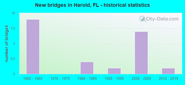
- New bridges - historical statistics
- 91960-1969
- 21980-1989
- 11990-1999
- 72000-2009
- 12010-2019


- Bridge Condition - Deck
- 68.8%Good
- 31.3%Satisfactory

- Bridge Condition - Superstructure
- 56.3%Good
- 37.5%Satisfactory
- 6.3%Fair

- Bridge Condition - Substructure
- 6.3%Very good
- 68.8%Good
- 12.5%Satisfactory
- 6.3%Fair
- 6.3%Poor

- Bridge Condition - Channel
- 33.3%Excellent
- 16.7%Good
- 33.3%Satisfactory
- 16.7%Fair
Find on map >> Show street view
Structure Number: 570038, Location: West end of County Line (Lat: 30.685025, Lng: -86.792411), Route carried "on" structure: County highway , Year Built: 1968, Status: Open, Structure Length: 6.58m (21.59ft), Average Daily Traffic: 171 (year 2010), Truck Traffic: 1%, Average Future Daily Traffic: 307 (year 2037), Design Load: HS 20, Features Intersected: I10 SR8, Facility Carried by Structure: Garnier Landing Rd
Minimum Vertical Clearance: 30+ m (98+ ft), Kilometerpoint: 4.324, Lanes on structure: 2, Lanes under structure: 4, Owner: State Highway Agency, Approaching Roadway Width: 7.3m (24.0ft), Skew: 1 degrees, Material/Design: Prestressed concrete, Design/Construction: Stringer/Multi-beam, Number Of Spans In Main Unit: 2, Length of Maximum Span: 32.9m (107.9ft), Curb-To-Curb Width: 7.3m (24.0ft), Out-to-Out Width: 8.9m (29.2ft)
Condition: Deck: Satisfactory, Superstructure: Good, Substructure: Good, Inventory Rating: 66.2 metric tons, Method Used To Determine Inventory Rating: Load Factor (LF), Structural Evaluation: Better than present minimum criteria, Deck Geometry: Somewhat better than minimum adequacy, Underclear: Equal to present minimum criteria, Approach Roadway Alignment: Equal to present desirable criteria, Designated Inspection Frequency: Every 24 months, Inspection Date: October 2020, Deck Structure Type: Concrete Cast-file-Place
Find on map >> Show street view
Structure Number: 570046, Location: 2.6 Mi. E. of County Line (Lat: 30.698761, Lng: -86.751444), Route carried "on" structure: Interstate 10, Year Built: 1969, Status: Open, Structure Length: 5.21m (17.09ft), Average Daily Traffic: 13,644 (year 2020), Truck Traffic: 26%, Average Future Daily Traffic: 23,671 (year 2042), Design Load: HS 20, Features Intersected: CR189
Minimum Vertical Clearance: 30+ m (98+ ft), Kilometerpoint: 4.196, Lanes on structure: 2, Lanes under structure: 4, Base Highway Network: Yes, Owner: State Highway Agency, Approaching Roadway Width: 11.6m (38.1ft), Skew: 2 degrees, Material/Design: Prestressed concrete, Design/Construction: Stringer/Multi-beam, Number Of Spans In Main Unit: 2, Length of Maximum Span: 26.2m (86.0ft), Curb-To-Curb Width: 12.2m (40.0ft), Out-to-Out Width: 13.1m (43.0ft)
Condition: Deck: Satisfactory, Superstructure: Good, Substructure: Good, Operating Rating: 74.1 metric tons, Method Used To Determine Operating Rating: Load Factor (LF), Inventory Rating: 44.5 metric tons, Method Used To Determine Inventory Rating: Load Factor (LF), Structural Evaluation: Better than present minimum criteria, Deck Geometry: Better than present minimum criteria, Underclear: Equal to present minimum criteria, Approach Roadway Alignment: Equal to present desirable criteria, Designated Inspection Frequency: Every 24 months, Inspection Date: September 2020, Deck Structure Type: Concrete Cast-file-Place
Find on map >> Show street view
Structure Number: 570066, Location: 2.6 mi. E. of County Line (Lat: 30.698531, Lng: -86.751356), Route carried "on" structure: Interstate 10, Year Built: 1969, Status: Open, Structure Length: 5.18m (16.99ft), Average Daily Traffic: 13,644 (year 2020), Truck Traffic: 26%, Average Future Daily Traffic: 23,671 (year 2042), Design Load: HS 20+Mod, Features Intersected: CR189
Minimum Vertical Clearance: 30+ m (98+ ft), Kilometerpoint: 4.179, Lanes on structure: 2, Lanes under structure: 4, Base Highway Network: Yes, Owner: State Highway Agency, Approaching Roadway Width: 11.6m (38.1ft), Skew: 2 degrees, Material/Design: Prestressed concrete, Design/Construction: Stringer/Multi-beam, Number Of Spans In Main Unit: 2, Length of Maximum Span: 26.2m (86.0ft), Curb-To-Curb Width: 12.2m (40.0ft), Out-to-Out Width: 13.1m (43.0ft)
Condition: Deck: Satisfactory, Superstructure: Good, Substructure: Good, Operating Rating: 74.1 metric tons, Method Used To Determine Operating Rating: Load Factor (LF), Inventory Rating: 44.5 metric tons, Method Used To Determine Inventory Rating: Load Factor (LF), Structural Evaluation: Better than present minimum criteria, Deck Geometry: Better than present minimum criteria, Underclear: Equal to present minimum criteria, Approach Roadway Alignment: Equal to present desirable criteria, Designated Inspection Frequency: Every 24 months, Inspection Date: September 2020, Deck Structure Type: Concrete Cast-file-Place
Find on map >> Show street view
Structure Number: 570812, Location: 0.1 Mi SW of Bryant Brdge (Lat: 30.722056, Lng: -86.791611), Route carried "on" structure: State lands road , Year Built: 2000, Status: Open, Structure Length: 0.80m (2.62ft), Average Daily Traffic: 25 (year 2020), Average Future Daily Traffic: 44 (year 2042), Design Load: HS 20, Features Intersected: Milo Creek, Facility Carried by Structure: Shammah Road
Minimum Vertical Clearance: 30+ m (98+ ft), Kilometerpoint: 0.161, Lanes on structure: 1, Owner: State Park, Forest, or Reservation Agency, Approaching Roadway Width: 3.0m (9.8ft), Material/Design: Steel, Design/Construction: Stringer/Multi-beam, Number Of Spans In Main Unit: 1, Length of Maximum Span: 8.0m (26.2ft), Curb-To-Curb Width: 3.4m (11.2ft), Out-to-Out Width: 3.7m (12.1ft)
Condition: Deck: Good, Superstructure: Satisfactory, Substructure: Good, Channel: Excellent, Operating Rating: 77.1 metric tons, Method Used To Determine Operating Rating: Load Factor (LF), Inventory Rating: 46.3 metric tons, Method Used To Determine Inventory Rating: Load Factor (LF), Structural Evaluation: Equal to present minimum criteria, Deck Geometry: High priority of corrective action, Waterway Adequacy: Equal to present desirable criteria, Approach Roadway Alignment: Equal to present desirable criteria, Designated Inspection Frequency: Every 24 months, Inspection Date: May 2020, Deck Structure Type: Wood or Timber
Find on map >> Show street view
Structure Number: 574008, Location: 0.9 Mi NW of Kelly Mills (Lat: 30.751403, Lng: -86.781769), Route carried "on" structure: County highway , Year Built: 1987, Status: Posted for load, Structure Length: 1.73m (5.68ft), Average Daily Traffic: 50 (year 2020), Average Future Daily Traffic: 87 (year 2042), Design Load: HS 20, Features Intersected: Penny Creek No. 1, Facility Carried by Structure: Penny Creek Road
Minimum Vertical Clearance: 30+ m (98+ ft), Kilometerpoint: 1.427, Lanes on structure: 1, Owner: County Highway Agency, Approaching Roadway Width: 5.5m (18.0ft), Material/Design: Wood or Timber, Design/Construction: Stringer/Multi-beam, Number Of Spans In Main Unit: 5, Length of Maximum Span: 3.6m (11.8ft), Curb or Sidewalk Widths: Left: 0.2m (0.7ft), Right: 0.2m (0.7ft), Curb-To-Curb Width: 5.5m (18.0ft), Out-to-Out Width: 6.1m (20.0ft)
Condition: Deck: Good, Superstructure: Satisfactory, Substructure: Good, Channel: Satisfactory, Operating Rating: 22.5 metric tons, Method Used To Determine Operating Rating: Allowable Stress (AS), Inventory Rating: 17.0 metric tons, Method Used To Determine Inventory Rating: Allowable Stress (AS), Structural Evaluation: Somewhat better than minimum adequacy, Deck Geometry: Meets minimum limits, Waterway Adequacy: Better than present minimum criteria, Approach Roadway Alignment: Equal to present minimum criteria, Bridge Posting: Required (Relationship of Operating Rating to Maximum Legal Load: 10.0 - 19.9% below), Designated Inspection Frequency: Every 24 months, Other Special Inspection Frequency: Every 12 months, Inspection Date: June 2020, Other Special Inspection Date: June 2021, Deck Structure Type: Wood or Timber
Find on map >> Show street view
Structure Number: 574112, Location: 1.2Mi S of LighthouseCh R (Lat: 30.739133, Lng: -86.749625), Route carried "on" structure: County highway , Year Built: 1985, Status: Posted for load, Structure Length: 1.83m (6.00ft), Average Daily Traffic: 50 (year 2020), Average Future Daily Traffic: 87 (year 2042), Features Intersected: Bone Creek, Facility Carried by Structure: Poplar Head Ch Rd
Minimum Vertical Clearance: 30+ m (98+ ft), Kilometerpoint: 2.733, Lanes on structure: 2, Owner: County Highway Agency, Approaching Roadway Width: 5.8m (19.0ft), Material/Design: Wood or Timber, Design/Construction: Stringer/Multi-beam, Number Of Spans In Main Unit: 4, Length of Maximum Span: 4.9m (16.1ft), Curb or Sidewalk Widths: Left: 0.3m (1.0ft), Right: 0.3m (1.0ft), Curb-To-Curb Width: 6.6m (21.7ft), Out-to-Out Width: 7.3m (24.0ft)
Condition: Deck: Satisfactory, Superstructure: Satisfactory, Substructure: Satisfactory, Channel: Good, Operating Rating: 31.8 metric tons, Method Used To Determine Operating Rating: Allowable Stress (AS), Inventory Rating: 22.7 metric tons, Method Used To Determine Inventory Rating: Allowable Stress (AS), Structural Evaluation: Equal to present minimum criteria, Deck Geometry: Somewhat better than minimum adequacy, Waterway Adequacy: Better than present minimum criteria, Approach Roadway Alignment: Equal to present desirable criteria, Bridge Posting: Required (Relationship of Operating Rating to Maximum Legal Load: 10.0 - 19.9% below), Designated Inspection Frequency: Every 24 months, Other Special Inspection Frequency: Every 12 months, Inspection Date: June 2020, Other Special Inspection Date: June 2021, Deck Structure Type: Wood or Timber
Find on map >> Show street view
Structure Number: 57415, Location: 1.7 Mi N of Bryant Bridge (Lat: 30.738417, Lng: -86.774756), Route carried "on" structure: County highway , Year Built: 2006, Status: Open, Structure Length: 1.46m (4.79ft), Average Daily Traffic: 100 (year 2020), Truck Traffic: 1%, Average Future Daily Traffic: 174 (year 2042), Design Load: HS 20, Features Intersected: Bone Creek No. 1, Facility Carried by Structure: Kelly Mill Road
Minimum Vertical Clearance: 30+ m (98+ ft), Kilometerpoint: 3.747, Lanes on structure: 2, Owner: County Highway Agency, Approaching Roadway Width: 6.6m (21.7ft), Material/Design: Concrete, Design/Construction: Channel Beam, Number Of Spans In Main Unit: 2, Length of Maximum Span: 7.3m (24.0ft), Curb-To-Curb Width: 7.6m (24.9ft), Out-to-Out Width: 8.4m (27.6ft)
Condition: Deck: Good, Superstructure: Good, Substructure: Good, Channel: Excellent, Inventory Rating: 59.9 metric tons, Method Used To Determine Inventory Rating: Load Factor (LF), Structural Evaluation: Better than present minimum criteria, Deck Geometry: Equal to present minimum criteria, Waterway Adequacy: Better than present minimum criteria, Approach Roadway Alignment: Equal to present desirable criteria, Designated Inspection Frequency: Every 24 months, Inspection Date: April 2020, Deck Structure Type: Concrete Precast Panels, Wearing Surface/Protective System: Wearing Surface: Bituminous
Find on map >> Show street view
Structure Number: 580082, Location: 5.5 Miles W. of County Ln (Lat: 30.656186, Lng: -86.878311), Route carried "on" structure: County highway , Year Built: 1968, Status: Open, Structure Length: 6.34m (20.80ft), Average Daily Traffic: 105 (year 2011), Average Future Daily Traffic: 142 (year 2033), Design Load: HS 20, Features Intersected: I10 SR8, Facility Carried by Structure: Miller Bluff Road
Minimum Vertical Clearance: 30+ m (98+ ft), Kilometerpoint: 7.586, Lanes on structure: 2, Lanes under structure: 4, Owner: State Highway Agency, Approaching Roadway Width: 6.1m (20.0ft), Material/Design: Prestressed concrete, Design/Construction: Stringer/Multi-beam, Number Of Spans In Main Unit: 2, Length of Maximum Span: 31.7m (104.0ft), Curb or Sidewalk Widths: Left: 0.5m (1.6ft), Right: 0.5m (1.6ft), Curb-To-Curb Width: 7.3m (24.0ft), Out-to-Out Width: 9.0m (29.5ft)
Condition: Deck: Good, Superstructure: Good, Substructure: Good, Inventory Rating: 69.9 metric tons, Method Used To Determine Inventory Rating: Load Factor (LF), Structural Evaluation: Better than present minimum criteria, Deck Geometry: Somewhat better than minimum adequacy, Underclear: Somewhat better than minimum adequacy, Approach Roadway Alignment: Equal to present desirable criteria, Designated Inspection Frequency: Every 24 months, Inspection Date: September 2020, Deck Structure Type: Concrete Cast-file-Place
Find on map >> Show street view
Structure Number: 580815, Location: 0.8 Mi E of Deaton Bdg Rd (Lat: 30.713611, Lng: -86.867361), Route carried "on" structure: State lands road , Year Built: 2001, Status: Open, Structure Length: 0.77m (2.53ft), Average Daily Traffic: 100 (year 2021), Average Future Daily Traffic: 174 (year 2042), Design Load: HS 20, Features Intersected: Hynote Branch, Facility Carried by Structure: Boat Ramp Road
Minimum Vertical Clearance: 30+ m (98+ ft), Kilometerpoint: 1.241, Lanes on structure: 1, Owner: State Park, Forest, or Reservation Agency, Approaching Roadway Width: 3.0m (9.8ft), Material/Design: Steel, Design/Construction: Stringer/Multi-beam, Number Of Spans In Main Unit: 1, Length of Maximum Span: 7.7m (25.3ft), Curb-To-Curb Width: 7.1m (23.3ft), Out-to-Out Width: 7.3m (24.0ft)
Condition: Deck: Good, Superstructure: Satisfactory, Substructure: Good, Channel: Satisfactory, Operating Rating: 69.0 metric tons, Method Used To Determine Operating Rating: Load Factor (LF), Inventory Rating: 41.5 metric tons, Method Used To Determine Inventory Rating: Load Factor (LF), Structural Evaluation: Equal to present minimum criteria, Deck Geometry: Somewhat better than minimum adequacy, Waterway Adequacy: Equal to present minimum criteria, Approach Roadway Alignment: Equal to present desirable criteria, Designated Inspection Frequency: Every 24 months, Inspection Date: June 2021, Deck Structure Type: Wood or Timber, Wearing Surface/Protective System: Wearing Surface: Bituminous
Find on map >> Show street view
Structure Number: 580817, Location: 0.1 Mi N of Bryant Bridge (Lat: 30.730828, Lng: -86.801517), Route carried "on" structure: State lands road , Year Built: 2002, Status: Open, Structure Length: 2.32m (7.61ft), Average Daily Traffic: 100 (year 2020), Average Future Daily Traffic: 174 (year 2042), Design Load: HS 20, Features Intersected: Ates Creek #1, Facility Carried by Structure: Hatchery Road
Minimum Vertical Clearance: 30+ m (98+ ft), Kilometerpoint: 0.175, Lanes on structure: 2, Owner: State Park, Forest, or Reservation Agency, Approaching Roadway Width: 6.7m (22.0ft), Material/Design: Steel, Design/Construction: Stringer/Multi-beam, Number Of Spans In Main Unit: 3, Length of Maximum Span: 7.7m (25.3ft), Curb-To-Curb Width: 7.2m (23.6ft), Out-to-Out Width: 7.2m (23.6ft)
Condition: Deck: Good, Superstructure: Satisfactory, Substructure: Satisfactory, Channel: Fair, Operating Rating: 71.7 metric tons, Method Used To Determine Operating Rating: Load Factor (LF), Inventory Rating: 42.6 metric tons, Method Used To Determine Inventory Rating: Load Factor (LF), Structural Evaluation: Equal to present minimum criteria, Deck Geometry: Somewhat better than minimum adequacy, Waterway Adequacy: Equal to present minimum criteria, Approach Roadway Alignment: Equal to present desirable criteria, Designated Inspection Frequency: Every 24 months, Underwater Inspection Frequency: Every 24 months, Inspection Date: April 2020, Underwater Inspection Date: April 2020, Deck Structure Type: Wood or Timber, Wearing Surface/Protective System: Wearing Surface: Bituminous
Find on map >> Show street view
Structure Number: 58082, Location: 0.76MI N of Bryant Br (Lat: 30.742861, Lng: -86.806722), Route carried "on" structure: State lands road , Year Built: 2007, Status: Open, Structure Length: 2.44m (8.01ft), Average Daily Traffic: 75 (year 2021), Average Future Daily Traffic: 130 (year 2042), Design Load: HS 20, Features Intersected: Ates Creek, Facility Carried by Structure: Norman Riley Road
Minimum Vertical Clearance: 30+ m (98+ ft), Kilometerpoint: 1.204, Lanes on structure: 2, Owner: State Park, Forest, or Reservation Agency, Approaching Roadway Width: 5.7m (18.7ft), Material/Design: Concrete, Design/Construction: Channel Beam, Number Of Spans In Main Unit: 2, Length of Maximum Span: 12.2m (40.0ft), Curb-To-Curb Width: 7.5m (24.6ft), Out-to-Out Width: 8.4m (27.6ft)
Condition: Deck: Good, Superstructure: Satisfactory, Substructure: Fair, Channel: Fair, Operating Rating: 60.8 metric tons, Method Used To Determine Operating Rating: Load Factor (LF), Inventory Rating: 36.5 metric tons, Method Used To Determine Inventory Rating: Load Factor (LF), Structural Evaluation: Somewhat better than minimum adequacy, Deck Geometry: Equal to present minimum criteria, Waterway Adequacy: Equal to present desirable criteria, Approach Roadway Alignment: Equal to present desirable criteria, Designated Inspection Frequency: Every 24 months, Underwater Inspection Frequency: Every 24 months, Inspection Date: July 2021, Underwater Inspection Date: July 2021
Find on map >> Show street view
Structure Number: 580824, Location: 1.3 Mi N of Kelly Mill Rd (Lat: 30.724144, Lng: -86.793222), Route carried "on" structure: State lands road , Year Built: 2015, Status: Open, Structure Length: 8.38m (27.49ft), Average Daily Traffic: 200 (year 2021), Average Future Daily Traffic: 347 (year 2042), Design Load: HL 93, Features Intersected: Blackwater River, Facility Carried by Structure: Bryant Bridge Road
Minimum Vertical Clearance: 30+ m (98+ ft), Kilometerpoint: 17.172, Lanes on structure: 2, Owner: State Park, Forest, or Reservation Agency, Approaching Roadway Width: 7.5m (24.6ft), Material/Design: Concrete, Design/Construction: Channel Beam, Number Of Spans In Main Unit: 5, Number Of Approach Spans: 3, Length of Maximum Span: 12.2m (40.0ft), Curb-To-Curb Width: 7.5m (24.6ft), Out-to-Out Width: 8.6m (28.2ft)
Condition: Deck: Good, Superstructure: Good, Substructure: Good, Channel: Satisfactory, Operating Rating: 36.0 metric tons, Method Used To Determine Operating Rating: Load and Resistance Factor (LRFR), Inventory Rating: 27.8 metric tons, Method Used To Determine Inventory Rating: Load and Resistance Factor (LRFR), Structural Evaluation: Equal to present minimum criteria, Deck Geometry: Somewhat better than minimum adequacy, Waterway Adequacy: Equal to present minimum criteria, Approach Roadway Alignment: Equal to present desirable criteria, Designated Inspection Frequency: Every 24 months, Inspection Date: August 2021, Deck Structure Type: Concrete Precast Panels
Find on map >> Show street view
Structure Number: 584178, Location: 2.14 Mi S of Bob Pitts Rd (Lat: 30.704800, Lng: -86.881856), Route carried "on" structure: County highway , Year Built: 1999, Status: Open, Structure Length: 7.72m (25.33ft), Average Daily Traffic: 500 (year 2021), Truck Traffic: 5%, Average Future Daily Traffic: 868 (year 2042), Features Intersected: Blackwater River, Facility Carried by Structure: Deaton Bridge Road
Minimum Vertical Clearance: 30+ m (98+ ft), Kilometerpoint: 13.409, Lanes on structure: 2, Owner: County Highway Agency, Approaching Roadway Width: 7.0m (23.0ft), Material/Design: Steel, Design/Construction: Stringer/Multi-beam, Number Of Spans In Main Unit: 11, Length of Maximum Span: 7.2m (23.6ft), Curb or Sidewalk Widths: Left: 1.4m (4.6ft), Right: 0.1m (0.3ft), Curb-To-Curb Width: 7.0m (23.0ft), Out-to-Out Width: 9.1m (29.9ft)
Condition: Deck: Good, Superstructure: Good, Substructure: Good, Channel: Good, Operating Rating: 50.8 metric tons, Method Used To Determine Operating Rating: Load Factor (LF), Inventory Rating: 29.9 metric tons, Method Used To Determine Inventory Rating: Load Factor (LF), Structural Evaluation: Better than present minimum criteria, Deck Geometry: Meets minimum limits, Waterway Adequacy: Better than present minimum criteria, Approach Roadway Alignment: Equal to present desirable criteria, Designated Inspection Frequency: Every 24 months, Underwater Inspection Frequency: Every 24 months, Inspection Date: May 2021, Underwater Inspection Date: May 2021, Deck Structure Type: Wood or Timber, Wearing Surface/Protective System: Wearing Surface: Bituminous
Find on map >> Show street view
Structure Number: 584188, Location: 0.71 Mi E of Miller Blf (Lat: 30.626956, Lng: -86.846300), Route carried "on" structure: Other road , Year Built: 2003, Status: Open, Structure Length: 1.25m (4.10ft), Average Daily Traffic: 50 (year 2020), Average Future Daily Traffic: 87 (year 2042), Features Intersected: Burnt Grocery Creek, Facility Carried by Structure: Fisher Old Mill Rd
Minimum Vertical Clearance: 30+ m (98+ ft), Kilometerpoint: 0.000, Lanes on structure: 1, Owner: County Highway Agency, Approaching Roadway Width: 3.7m (12.1ft), Material/Design: Wood or Timber, Design/Construction: Stringer/Multi-beam, Number Of Spans In Main Unit: 4, Length of Maximum Span: 3.4m (11.2ft), Curb or Sidewalk Widths: Left: 0.1m (0.3ft), Right: 0.1m (0.3ft), Curb-To-Curb Width: 5.8m (19.0ft), Out-to-Out Width: 6.1m (20.0ft)
Condition: Deck: Satisfactory, Superstructure: Good, Substructure: Good, Channel: Excellent, Operating Rating: 37.2 metric tons, Method Used To Determine Operating Rating: Allowable Stress (AS), Inventory Rating: 28.1 metric tons, Method Used To Determine Inventory Rating: Allowable Stress (AS), Structural Evaluation: Better than present minimum criteria, Deck Geometry: Meets minimum limits, Waterway Adequacy: Better than present minimum criteria, Approach Roadway Alignment: Equal to present desirable criteria, Designated Inspection Frequency: Every 24 months, Inspection Date: November 2020, Deck Structure Type: Wood or Timber
Find on map >> Show street view
Structure Number: 584191, Location: 3.7 Mi E of Miller Bluff (Lat: 30.655897, Lng: -86.817908), Route carried "on" structure: County highway , Year Built: 2004, Status: Open, Structure Length: 1.54m (5.05ft), Average Daily Traffic: 50 (year 2021), Average Future Daily Traffic: 87 (year 2042), Features Intersected: Garnier Creek, Facility Carried by Structure: Blue Barnes Road
Minimum Vertical Clearance: 30+ m (98+ ft), Kilometerpoint: 6.027, Lanes on structure: 2, Owner: County Highway Agency, Approaching Roadway Width: 5.8m (19.0ft), Material/Design: Wood or Timber, Design/Construction: Stringer/Multi-beam, Number Of Spans In Main Unit: 5, Length of Maximum Span: 3.1m (10.2ft), Curb or Sidewalk Widths: Left: 0.1m (0.3ft), Right: 0.1m (0.3ft), Curb-To-Curb Width: 5.5m (18.0ft), Out-to-Out Width: 5.8m (19.0ft)
Condition: Deck: Good, Superstructure: Good, Substructure: Very good, Channel: Excellent, Operating Rating: 32.7 metric tons, Method Used To Determine Operating Rating: Allowable Stress (AS), Inventory Rating: 23.6 metric tons, Method Used To Determine Inventory Rating: Allowable Stress (AS), Structural Evaluation: Equal to present minimum criteria, Deck Geometry: Meets minimum limits, Waterway Adequacy: Equal to present minimum criteria, Approach Roadway Alignment: Equal to present desirable criteria, Designated Inspection Frequency: Every 24 months, Inspection Date: December 2021, Deck Structure Type: Wood or Timber, Wearing Surface/Protective System: Wearing Surface: Bituminous
Find on map >> Show street view
Structure Number: AFFLFTFA12203, Location: 14 MILES WEST OF S.R. 85 (Lat: 30.632056, Lng: -86.774972), Route carried "on" structure: Federal lands road 211, Year Built: 1965, Status: Posted for load, Structure Length: 1.08m (3.54ft), Average Daily Traffic: 50 (year 2021), Average Future Daily Traffic: 55 (year 2041), Features Intersected: MILLIGAN CREEK
Minimum Vertical Clearance: 30+ m (98+ ft), Kilometerpoint: 0.000, Lanes on structure: 1, Owner: Air Force, Approaching Roadway Width: 3.8m (12.5ft), Material/Design: Wood or Timber, Design/Construction: Stringer/Multi-beam, Number Of Spans In Main Unit: 3, Length of Maximum Span: 3.7m (12.1ft), Curb-To-Curb Width: 3.4m (11.2ft), Out-to-Out Width: 3.8m (12.5ft)
Condition: Deck: Good, Superstructure: Fair, Substructure: Poor, Channel: Satisfactory, Operating Rating: 28.1 metric tons, Method Used To Determine Operating Rating: Allowable Stress (AS), Inventory Rating: 20.9 metric tons, Method Used To Determine Inventory Rating: Allowable Stress (AS), Structural Evaluation: Meets minimum limits, Deck Geometry: High priority of corrective action, Waterway Adequacy: Equal to present minimum criteria, Approach Roadway Alignment: Equal to present desirable criteria, Bridge Posting: Required (Relationship of Operating Rating to Maximum Legal Load: 10.0 - 19.9% below), Designated Inspection Frequency: Every 24 months, Inspection Date: October 2021, Bridge Improvement Cost: $50,000, Roadway Improvement Cost: $5,000, Total Project Cost: $75,000, Deck Structure Type: Wood or Timber, Wearing Surface/Protective System: Wearing Surface: Wood or Timber
Find on map >> Show street view
Structure Number: 570038, Location: West end of County Line (Lat: 30.685025, Lng: -86.792411), Route carried "under" structure: Interstate 10, Year Built: 1968, Structure Length: 0. m, Average Daily Traffic: 30,500 (year 2020), Truck Traffic: 24%, Features Intersected: I10 SR8, Facility Carried by Structure: Garnier Landing Rd
Minimum Vertical Clearance: 5.03m (16.50ft), Kilometerpoint: 0.000, Lanes on structure: 2, Lanes under structure: 4, Material/Design: Prestressed concrete, Design/Construction: Stringer/Multi-beam, Length of Maximum Span: 32.9m (107.9ft)
Find on map >> Show street view
Structure Number: 570046, Location: 2.6 Mi. E. of County Line (Lat: 30.698761, Lng: -86.751444), Route carried "under" structure: County highway 189, Year Built: 1969, Structure Length: 0. m, Average Daily Traffic: 1,371 (year 2000), Truck Traffic: 22%, Features Intersected: CR189, Facility Carried by Structure: I10 SR8
Minimum Vertical Clearance: 4.75m (15.58ft), Kilometerpoint: 0.272, Lanes on structure: 2, Lanes under structure: 4, Material/Design: Prestressed concrete, Design/Construction: Stringer/Multi-beam, Length of Maximum Span: 26.2m (86.0ft)
Find on map >> Show street view
Structure Number: 570066, Location: 2.6 mi. E. of County Line (Lat: 30.698531, Lng: -86.751356), Route carried "under" structure: County highway 189, Year Built: 1969, Structure Length: 0. m, Average Daily Traffic: 1,371 (year 2000), Truck Traffic: 22%, Features Intersected: CR189, Facility Carried by Structure: I10 SR8
Minimum Vertical Clearance: 5.02m (16.47ft), Kilometerpoint: 0.241, Lanes on structure: 2, Lanes under structure: 4, Material/Design: Prestressed concrete, Design/Construction: Stringer/Multi-beam, Length of Maximum Span: 26.2m (86.0ft)
Find on map >> Show street view
Structure Number: 580082, Location: 5.5 Miles W. of County Ln (Lat: 30.656186, Lng: -86.878311), Route carried "under" structure: Interstate 10, Year Built: 1968, Structure Length: 0. m, Average Daily Traffic: 30,500 (year 2020), Truck Traffic: 24%, Features Intersected: I10 SR8, Facility Carried by Structure: Miller Bluff Road
Minimum Vertical Clearance: 4.97m (16.31ft), Kilometerpoint: 32.816, Lanes on structure: 2, Lanes under structure: 4, Material/Design: Prestressed concrete, Design/Construction: Stringer/Multi-beam, Length of Maximum Span: 31.7m (104.0ft)