Bridge Statistics for Hanna, Indiana (IN)
Condition, Traffic, Stress, Structural Evaluation, Project Costs
- National Bridge Inventory (NBI) Statistics
- 17Number of bridges
- 79ft / 23.7mTotal length
- $2,271,000Total costs
- 19,568Total average daily traffic
- 1,283Total average daily truck traffic
- 27,853Total future (year 2029) average daily traffic
- National Bridge Inventory (NBI) Registered Bridges for Hanna
- No street view available for this location
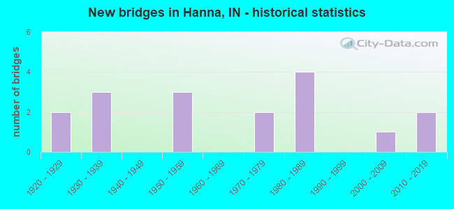
- New bridges - historical statistics
- 21920-1929
- 31930-1939
- 31950-1959
- 21970-1979
- 41980-1989
- 12000-2009
- 22010-2019

- Reconstructed bridges - Historical Statistics
- 11970-1979
- 21980-1989
- 11990-1999
- 02000-2009
- 42010-2019


- Bridge Condition - Deck
- 61.5%Good
- 23.1%Satisfactory
- 7.7%Fair
- 7.7%Poor

- Bridge Condition - Superstructure
- 7.7%Very good
- 61.5%Good
- 15.4%Satisfactory
- 7.7%Fair
- 7.7%Poor

- Bridge Condition - Substructure
- 38.5%Good
- 30.8%Satisfactory
- 30.8%Fair

- Bridge Condition - Channel
- 11.8%Very good
- 11.8%Good
- 35.3%Satisfactory
- 41.2%Fair

- Bridge Condition - Culverts
- 75.0%Satisfactory
- 25.0%Fair
Find on map >> Show street view
Structure Number: 822, Location: 01.98 W SR 39 (Lat: 41.413550, Lng: -86.772711), Route carried "on" structure: US 30, Year Built: 1958, Year Reconstructed: 2015, Status: Open, Structure Length: 2.50m (8.20ft), Average Daily Traffic: 6,300 (year 2015), Average Future Daily Traffic: 8,924 (year 2030), Design Load: HS 20, Features Intersected: HUNSLEY DITCH
Minimum Vertical Clearance: 30+ m (98+ ft), Kilometerpoint: 13.808, Lanes on structure: 2, Base Highway Network: Yes (, Subroute: 1), Owner: State Highway Agency, Approaching Roadway Width: 11.6m (38.1ft), Skew: 3 degrees, Material/Design: Concrete continuous, Design/Construction: Slab, Number Of Spans In Main Unit: 3, Length of Maximum Span: 9.8m (32.2ft), Curb-To-Curb Width: 12.4m (40.7ft), Out-to-Out Width: 13.3m (43.6ft)
Condition: Deck: Satisfactory, Superstructure: Satisfactory, Substructure: Good, Channel: Very good, Operating Rating: 45.4 metric tons, Method Used To Determine Operating Rating: Load and Resistance Factor Rating (LRFR) rating reported by rating factor(RF) method using HL-93 loadings, Inventory Rating: 35.0 metric tons, Method Used To Determine Inventory Rating: Load and Resistance Factor Rating (LRFR) rating reported by rating factor(RF) method using HL-93 loadings, Structural Evaluation: Equal to present minimum criteria, Deck Geometry: Better than present minimum criteria, Waterway Adequacy: Equal to present desirable criteria, Approach Roadway Alignment: Equal to present desirable criteria, Designated Inspection Frequency: Every 24 months, Inspection Date: March 2022, Deck Structure Type: Concrete Cast-file-Place, Wearing Surface/Protective System: Wearing Surface: Monolithic Concrete, Deck Protection: Epoxy Coated Reinforcing
Find on map >> Show street view
Structure Number: 823, Location: 01.98 W SR 39 (Lat: 41.413789, Lng: -86.772689), Route carried "on" structure: US 30, Year Built: 1958, Year Reconstructed: 2015, Status: Open, Structure Length: 2.50m (8.20ft), Average Daily Traffic: 6,443 (year 2004), Truck Traffic: 10%, Average Future Daily Traffic: 8,924 (year 2030), Design Load: HS 20, Features Intersected: HUNSLEY DITCH
Minimum Vertical Clearance: 30+ m (98+ ft), Kilometerpoint: 13.808, Lanes on structure: 2, Base Highway Network: Yes (, Subroute: 1), Owner: State Highway Agency, Approaching Roadway Width: 11.6m (38.1ft), Skew: 3 degrees, Material/Design: Concrete continuous, Design/Construction: Slab, Number Of Spans In Main Unit: 3, Length of Maximum Span: 9.8m (32.2ft), Curb-To-Curb Width: 12.4m (40.7ft), Out-to-Out Width: 13.3m (43.6ft)
Condition: Deck: Good, Superstructure: Good, Substructure: Good, Channel: Very good, Operating Rating: 45.4 metric tons, Method Used To Determine Operating Rating: Load and Resistance Factor Rating (LRFR) rating reported by rating factor(RF) method using HL-93 loadings, Inventory Rating: 35.0 metric tons, Method Used To Determine Inventory Rating: Load and Resistance Factor Rating (LRFR) rating reported by rating factor(RF) method using HL-93 loadings, Structural Evaluation: Better than present minimum criteria, Deck Geometry: Better than present minimum criteria, Waterway Adequacy: Equal to present desirable criteria, Approach Roadway Alignment: Equal to present desirable criteria, Length Of Structure Improvement: 2.50m (8.20ft), Designated Inspection Frequency: Every 24 months, Inspection Date: March 2022, Deck Structure Type: Concrete Cast-file-Place, Wearing Surface/Protective System: Wearing Surface: Monolithic Concrete, Deck Protection: Epoxy Coated Reinforcing
Find on map >> Show street view
Structure Number: 135, Location: 02.11 S US 30 (Lat: 41.375231, Lng: -86.736911), Route carried "on" structure: State highway 39, Year Built: 1951, Status: Open, Structure Length: 0.70m (2.30ft), Average Daily Traffic: 2,120 (year 2004), Truck Traffic: 10%, Average Future Daily Traffic: 3,518 (year 2029), Design Load: H 20, Features Intersected: MARQUARDT DITCH
Minimum Vertical Clearance: 30+ m (98+ ft), Kilometerpoint: 4.152, Lanes on structure: 2, Owner: State Highway Agency, Approaching Roadway Width: 10.4m (34.1ft), Skew: 1 degrees, Material/Design: Concrete, Design/Construction: Culvert, Number Of Spans In Main Unit: 1, Length of Maximum Span: 6.1m (20.0ft), Curb or Sidewalk Widths: Left: 0.3m (1.0ft), Right: 0.3m (1.0ft), Curb-To-Curb Width: 10.8m (35.4ft), Out-to-Out Width: 11.4m (37.4ft)
Condition: Channel: Good, Culverts: Satisfactory, Operating Rating: 97.2 metric tons, Method Used To Determine Operating Rating: Load and Resistance Factor Rating (LRFR) rating reported by rating factor(RF) method using HL-93 loadings, Inventory Rating: 87.5 metric tons, Method Used To Determine Inventory Rating: Load and Resistance Factor Rating (LRFR) rating reported by rating factor(RF) method using HL-93 loadings, Structural Evaluation: Equal to present minimum criteria, Deck Geometry: Somewhat better than minimum adequacy, Waterway Adequacy: Equal to present minimum criteria, Approach Roadway Alignment: Equal to present desirable criteria, Designated Inspection Frequency: Every 24 months, Inspection Date: December 2021
Find on map >> Show street view
Structure Number: 460004, Location: 00.70 N CR 1050 S (Lat: 41.465339, Lng: -86.757089), Route carried "on" structure: County highway 55, Year Built: 2002, Status: Open, Structure Length: 2.24m (7.35ft), Average Daily Traffic: 350 (year 2020), Truck Traffic: 5%, Average Future Daily Traffic: 550 (year 2040), Features Intersected: MILL CREEK, Facility Carried by Structure: CR 300 W (LONG LAN
Minimum Vertical Clearance: 30+ m (98+ ft), Kilometerpoint: 0.000, Lanes on structure: 2, Owner: County Highway Agency, Approaching Roadway Width: 6.7m (22.0ft), Material/Design: Concrete continuous, Design/Construction: Slab, Number Of Spans In Main Unit: 3, Length of Maximum Span: 8.4m (27.6ft), Curb-To-Curb Width: 8.5m (27.9ft), Out-to-Out Width: 9.4m (30.8ft)
Condition: Deck: Good, Superstructure: Good, Substructure: Good, Channel: Satisfactory, Operating Rating: 32.7 metric tons, Method Used To Determine Operating Rating: Field evaluation and documented engineering judgment, Inventory Rating: 32.7 metric tons, Method Used To Determine Inventory Rating: Field evaluation and documented engineering judgment, Structural Evaluation: Better than present minimum criteria, Deck Geometry: Equal to present minimum criteria, Waterway Adequacy: Better than present minimum criteria, Approach Roadway Alignment: Equal to present desirable criteria, Designated Inspection Frequency: Every 24 months, Inspection Date: September 2020, Deck Structure Type: Concrete Cast-file-Place, Wearing Surface/Protective System: Wearing Surface: Monolithic Concrete, Deck Protection: Epoxy Coated Reinforcing
Find on map >> Show street view
Structure Number: 4600041, Location: 00.50 N CR 900 S (Lat: 41.483219, Lng: -86.777019), Route carried "on" structure: County highway 49, Year Built: 1935, Year Reconstructed: 1976, Status: Open, Structure Length: 1.40m (4.59ft), Average Daily Traffic: 925 (year 2020), Truck Traffic: 5%, Average Future Daily Traffic: 1,600 (year 2040), Design Load: HS 20, Features Intersected: MILL CREEK, Facility Carried by Structure: CR 400W
Minimum Vertical Clearance: 30+ m (98+ ft), Kilometerpoint: 0.000, Lanes on structure: 2, Owner: County Highway Agency, Approaching Roadway Width: 6.7m (22.0ft), Material/Design: Prestressed concrete, Design/Construction: Box Beam or Girders - Multiple, Number Of Spans In Main Unit: 1, Length of Maximum Span: 12.6m (41.3ft), Curb-To-Curb Width: 7.3m (24.0ft), Out-to-Out Width: 7.3m (24.0ft)
Condition: Deck: Fair, Superstructure: Fair, Substructure: Satisfactory, Channel: Satisfactory, Operating Rating: 63.3 metric tons, Method Used To Determine Operating Rating: Load Factor (LF), Inventory Rating: 37.9 metric tons, Method Used To Determine Inventory Rating: Load Factor (LF), Structural Evaluation: Somewhat better than minimum adequacy, Deck Geometry: Meets minimum limits, Waterway Adequacy: Equal to present minimum criteria, Approach Roadway Alignment: Equal to present desirable criteria, Designated Inspection Frequency: Every 24 months, Inspection Date: September 2020, Deck Structure Type: Concrete Precast Panels, Wearing Surface/Protective System: Wearing Surface: Bituminous
Find on map >> Show street view
Structure Number: 4600046, Location: 00.50 W LONG LANE (Lat: 41.476600, Lng: -86.768231), Route carried "on" structure: County highway 38, Year Built: 1976, Year Reconstructed: 2016, Status: Open, Structure Length: 1.22m (4.00ft), Average Daily Traffic: 250 (year 2020), Truck Traffic: 5%, Average Future Daily Traffic: 400 (year 2040), Design Load: HS 20, Features Intersected: MILL CREEK, Facility Carried by Structure: CR 900S
Minimum Vertical Clearance: 30+ m (98+ ft), Kilometerpoint: 0.000, Lanes on structure: 2, Owner: County Highway Agency, Approaching Roadway Width: 6.1m (20.0ft), Material/Design: Prestressed concrete, Design/Construction: Box Beam or Girders - Multiple, Number Of Spans In Main Unit: 1, Length of Maximum Span: 11.9m (39.0ft), Curb-To-Curb Width: 7.3m (24.0ft), Out-to-Out Width: 7.3m (24.0ft)
Condition: Deck: Good, Superstructure: Satisfactory, Substructure: Fair, Channel: Fair, Operating Rating: 51.9 metric tons, Method Used To Determine Operating Rating: Load Factor (LF), Inventory Rating: 31.1 metric tons, Method Used To Determine Inventory Rating: Load Factor (LF), Structural Evaluation: Somewhat better than minimum adequacy, Deck Geometry: Somewhat better than minimum adequacy, Waterway Adequacy: Somewhat better than minimum adequacy, Approach Roadway Alignment: Equal to present minimum criteria, Designated Inspection Frequency: Every 24 months, Inspection Date: September 2020, Deck Structure Type: Concrete Cast-file-Place, Wearing Surface/Protective System: Wearing Surface: Monolithic Concrete
Find on map >> Show street view
Structure Number: 4600068, Location: 00.40 N OF CR 1800 S (Lat: 41.353450, Lng: -86.814839), Route carried "on" structure: County highway 29, Year Built: 1977, Year Reconstructed: 2016, Status: Open, Structure Length: 1.04m (3.41ft), Average Daily Traffic: 697 (year 2019), Truck Traffic: 19%, Average Future Daily Traffic: 859 (year 2040), Design Load: HS 20, Features Intersected: PITNER DITCH, Facility Carried by Structure: CR 600W
Minimum Vertical Clearance: 30+ m (98+ ft), Kilometerpoint: 0.000, Lanes on structure: 2, Owner: County Highway Agency, Approaching Roadway Width: 6.1m (20.0ft), Skew: 4 degrees, Material/Design: Prestressed concrete, Design/Construction: Box Beam or Girders - Multiple, Number Of Spans In Main Unit: 1, Length of Maximum Span: 9.9m (32.5ft), Curb-To-Curb Width: 7.2m (23.6ft), Out-to-Out Width: 7.3m (24.0ft)
Condition: Deck: Good, Superstructure: Good, Substructure: Satisfactory, Channel: Fair, Operating Rating: 80.8 metric tons, Method Used To Determine Operating Rating: Load Factor (LF), Inventory Rating: 48.4 metric tons, Method Used To Determine Inventory Rating: Load Factor (LF), Structural Evaluation: Equal to present minimum criteria, Deck Geometry: Meets minimum limits, Waterway Adequacy: Equal to present minimum criteria, Approach Roadway Alignment: Equal to present desirable criteria, Designated Inspection Frequency: Every 24 months, Inspection Date: September 2020, Deck Structure Type: Concrete Cast-file-Place, Wearing Surface/Protective System: Wearing Surface: Monolithic Concrete
Find on map >> Show street view
Structure Number: 4600069, Location: 00.40 S CR 1600 S (Lat: 41.369969, Lng: -86.814669), Route carried "on" structure: County highway 29, Year Built: 1934, Year Reconstructed: 1995, Status: Open, Structure Length: 1.22m (4.00ft), Average Daily Traffic: 697 (year 2019), Truck Traffic: 19%, Average Future Daily Traffic: 859 (year 2040), Design Load: HS 20, Features Intersected: GUSE ARM DITCH, Facility Carried by Structure: CR 600W
Minimum Vertical Clearance: 30+ m (98+ ft), Kilometerpoint: 0.000, Lanes on structure: 2, Owner: County Highway Agency, Approaching Roadway Width: 7.3m (24.0ft), Skew: 3 degrees, Material/Design: Prestressed concrete, Design/Construction: Box Beam or Girders - Multiple, Number Of Spans In Main Unit: 1, Length of Maximum Span: 11.1m (36.4ft), Curb-To-Curb Width: 8.4m (27.6ft), Out-to-Out Width: 8.6m (28.2ft)
Condition: Deck: Good, Superstructure: Good, Substructure: Fair, Channel: Satisfactory, Operating Rating: 59.2 metric tons, Method Used To Determine Operating Rating: Load Factor (LF), Inventory Rating: 35.5 metric tons, Method Used To Determine Inventory Rating: Load Factor (LF), Structural Evaluation: Somewhat better than minimum adequacy, Deck Geometry: Somewhat better than minimum adequacy, Waterway Adequacy: Better than present minimum criteria, Approach Roadway Alignment: Equal to present desirable criteria, Designated Inspection Frequency: Every 24 months, Inspection Date: September 2020, Deck Structure Type: Concrete Precast Panels, Wearing Surface/Protective System: Wearing Surface: Bituminous, Membrane: Preformed Fabric
Find on map >> Show street view
Structure Number: 4600089, Location: 00.60 E THOMPSON (Lat: 41.410419, Lng: -86.769319), Route carried "on" structure: County highway 30, Year Built: 1930, Status: Open, Structure Length: 0.76m (2.49ft), Average Daily Traffic: 150 (year 2018), Truck Traffic: 5%, Average Future Daily Traffic: 187 (year 2040), Features Intersected: HUNSLEY DITCH
Minimum Vertical Clearance: 30+ m (98+ ft), Kilometerpoint: 0.000, Lanes on structure: 2, Owner: County Highway Agency, Approaching Roadway Width: 7.0m (23.0ft), Material/Design: Concrete, Design/Construction: Stringer/Multi-beam, Number Of Spans In Main Unit: 1, Length of Maximum Span: 7.2m (23.6ft), Curb-To-Curb Width: 11.9m (39.0ft), Out-to-Out Width: 12.6m (41.3ft)
Condition: Deck: Satisfactory, Superstructure: Good, Substructure: Satisfactory, Channel: Good, Operating Rating: 32.7 metric tons, Method Used To Determine Operating Rating: Field evaluation and documented engineering judgment, Inventory Rating: 24.5 metric tons, Method Used To Determine Inventory Rating: Field evaluation and documented engineering judgment, Structural Evaluation: Equal to present minimum criteria, Deck Geometry: Superior to present desirable criteria, Waterway Adequacy: Somewhat better than minimum adequacy, Approach Roadway Alignment: Equal to present desirable criteria, Designated Inspection Frequency: Every 24 months, Inspection Date: September 2020, Deck Structure Type: Concrete Cast-file-Place, Wearing Surface/Protective System: Wearing Surface: Monolithic Concrete
Find on map >> Show street view
Structure Number: 4600092, Location: 01.00 W LONG LANE (Lat: 41.368119, Lng: -86.775411), Route carried "on" structure: County highway 132, Year Built: 1924, Year Reconstructed: 1986, Status: Open, Structure Length: 1.01m (3.31ft), Average Daily Traffic: 200 (year 2021), Truck Traffic: 5%, Average Future Daily Traffic: 250 (year 2041), Design Load: HS 20, Features Intersected: HANNA ARM-TUESBURG DITCH, Facility Carried by Structure: CR 1650S
Minimum Vertical Clearance: 30+ m (98+ ft), Kilometerpoint: 0.000, Lanes on structure: 2, Owner: County Highway Agency, Approaching Roadway Width: 6.7m (22.0ft), Material/Design: Prestressed concrete, Design/Construction: Box Beam or Girders - Multiple, Number Of Spans In Main Unit: 1, Length of Maximum Span: 9.1m (29.9ft), Curb-To-Curb Width: 7.2m (23.6ft), Out-to-Out Width: 7.4m (24.3ft)
Condition: Deck: Poor, Superstructure: Poor, Substructure: Fair, Channel: Satisfactory, Operating Rating: 64.5 metric tons, Method Used To Determine Operating Rating: Load Factor (LF), Inventory Rating: 38.6 metric tons, Method Used To Determine Inventory Rating: Load Factor (LF), Structural Evaluation: Meets minimum limits, Deck Geometry: Meets minimum limits, Waterway Adequacy: Equal to present minimum criteria, Approach Roadway Alignment: Equal to present minimum criteria, Length Of Structure Improvement: 1.22m (4.00ft), Designated Inspection Frequency: Every 12 months, Inspection Date: September 2021, Bridge Improvement Cost: $275,000, Roadway Improvement Cost: $125,000, Total Project Cost: $400,000 ( Estimate for 2021), Deck Structure Type: Concrete Precast Panels, Wearing Surface/Protective System: Wearing Surface: Bituminous, Membrane: Preformed Fabric
Find on map >> Show street view
Structure Number: 4600093, Location: 00.40 E CR 400 W (Lat: 41.389850, Lng: -86.765789), Route carried "on" structure: County highway 16, Year Built: 1986, Status: Open, Structure Length: 1.46m (4.79ft), Average Daily Traffic: 100 (year 2018), Truck Traffic: 5%, Average Future Daily Traffic: 125 (year 2040), Design Load: HS 20, Features Intersected: HANNA ARM-TUESBURG DITCH, Facility Carried by Structure: CR 1500S
Minimum Vertical Clearance: 30+ m (98+ ft), Kilometerpoint: 0.000, Lanes on structure: 2, Owner: County Highway Agency, Approaching Roadway Width: 7.0m (23.0ft), Material/Design: Prestressed concrete, Design/Construction: Box Beam or Girders - Multiple, Number Of Spans In Main Unit: 1, Length of Maximum Span: 12.6m (41.3ft), Curb-To-Curb Width: 7.2m (23.6ft), Out-to-Out Width: 7.4m (24.3ft)
Condition: Deck: Good, Superstructure: Good, Substructure: Good, Channel: Fair, Operating Rating: 69.8 metric tons, Method Used To Determine Operating Rating: Load Factor (LF), Inventory Rating: 41.8 metric tons, Method Used To Determine Inventory Rating: Load Factor (LF), Structural Evaluation: Better than present minimum criteria, Deck Geometry: Somewhat better than minimum adequacy, Waterway Adequacy: Equal to present desirable criteria, Approach Roadway Alignment: Equal to present desirable criteria, Designated Inspection Frequency: Every 24 months, Inspection Date: September 2020, Deck Structure Type: Concrete Precast Panels, Wearing Surface/Protective System: Wearing Surface: Bituminous, Membrane: Preformed Fabric
Find on map >> Show street view
Structure Number: 4600095, Location: 00.50 W LONG LN (Lat: 41.404350, Lng: -86.765639), Route carried "on" structure: County highway 18, Year Built: 1929, Year Reconstructed: 1986, Status: Open, Structure Length: 0.88m (2.89ft), Average Daily Traffic: 125 (year 2018), Truck Traffic: 5%, Average Future Daily Traffic: 156 (year 2040), Design Load: HS 20, Features Intersected: HANNA ARM-TUESBURG DITCH, Facility Carried by Structure: CR 1400S
Minimum Vertical Clearance: 30+ m (98+ ft), Kilometerpoint: 0.000, Lanes on structure: 2, Owner: County Highway Agency, Approaching Roadway Width: 6.7m (22.0ft), Material/Design: Prestressed concrete, Design/Construction: Box Beam or Girders - Multiple, Number Of Spans In Main Unit: 1, Length of Maximum Span: 7.9m (25.9ft), Curb-To-Curb Width: 7.1m (23.3ft), Out-to-Out Width: 7.3m (24.0ft)
Condition: Deck: Good, Superstructure: Good, Substructure: Satisfactory, Channel: Fair, Operating Rating: 93.0 metric tons, Method Used To Determine Operating Rating: Load Factor (LF), Inventory Rating: 55.7 metric tons, Method Used To Determine Inventory Rating: Load Factor (LF), Structural Evaluation: Equal to present minimum criteria, Deck Geometry: Meets minimum limits, Waterway Adequacy: Somewhat better than minimum adequacy, Approach Roadway Alignment: Equal to present desirable criteria, Designated Inspection Frequency: Every 24 months, Inspection Date: September 2020, Deck Structure Type: Concrete Precast Panels, Wearing Surface/Protective System: Wearing Surface: Bituminous, Membrane: Preformed Fabric
Find on map >> Show street view
Structure Number: 4600098, Location: 00.20 E CR 500 W (Lat: 41.375431, Lng: -86.790439), Route carried "on" structure: County highway 12, Year Built: 1988, Status: Posted for load, Structure Length: 1.02m (3.35ft), Average Daily Traffic: 100 (year 2018), Truck Traffic: 5%, Average Future Daily Traffic: 125 (year 2040), Design Load: HS 20, Features Intersected: PITNER DITCH, Facility Carried by Structure: CR 1600S
Minimum Vertical Clearance: 30+ m (98+ ft), Kilometerpoint: 0.000, Lanes on structure: 2, Owner: County Highway Agency, Approaching Roadway Width: 6.7m (22.0ft), Skew: 3 degrees, Material/Design: Steel, Design/Construction: Culvert, Number Of Spans In Main Unit: 2, Length of Maximum Span: 4.2m (13.8ft), Curb-To-Curb Width: 8.8m (28.9ft), Out-to-Out Width: 16.9m (55.4ft)
Condition: Channel: Fair, Culverts: Fair, Operating Rating: 16.5 metric tons, Method Used To Determine Operating Rating: Load and Resistance Factor (LRFR), Inventory Rating: 12.7 metric tons, Method Used To Determine Inventory Rating: Load and Resistance Factor (LRFR), Structural Evaluation: Meets minimum limits, Deck Geometry: Better than present minimum criteria, Waterway Adequacy: Somewhat better than minimum adequacy, Approach Roadway Alignment: Equal to present desirable criteria, Bridge Posting: Required (Relationship of Operating Rating to Maximum Legal Load: > 39.9% below), Length Of Structure Improvement: 1.02m (3.35ft), Designated Inspection Frequency: Every 24 months, Inspection Date: September 2020, Bridge Improvement Cost: $1,830,000, Roadway Improvement Cost: $41,000, Total Project Cost: $1,871,000 ( Estimate for 2020), Wearing Surface/Protective System: Wearing Surface: Bituminous
Find on map >> Show street view
Structure Number: 4600099, Location: 00.10 S CR 1600 S (Lat: 41.373819, Lng: -86.795000), Route carried "on" structure: County highway 35, Year Built: 1989, Status: Open, Structure Length: 0.96m (3.15ft), Average Daily Traffic: 100 (year 2018), Truck Traffic: 5%, Average Future Daily Traffic: 125 (year 2040), Design Load: HS 20, Features Intersected: PITNER DITCH, Facility Carried by Structure: CR 500W
Minimum Vertical Clearance: 30+ m (98+ ft), Kilometerpoint: 0.000, Lanes on structure: 2, Owner: County Highway Agency, Approaching Roadway Width: 7.3m (24.0ft), Skew: 2 degrees, Material/Design: Steel, Design/Construction: Culvert, Number Of Spans In Main Unit: 2, Length of Maximum Span: 3.9m (12.8ft), Curb-To-Curb Width: 9.4m (30.8ft), Out-to-Out Width: 20.1m (65.9ft)
Condition: Channel: Fair, Culverts: Satisfactory, Operating Rating: 42.5 metric tons, Method Used To Determine Operating Rating: Load and Resistance Factor (LRFR), Inventory Rating: 35.6 metric tons, Method Used To Determine Inventory Rating: Load and Resistance Factor (LRFR), Structural Evaluation: Equal to present minimum criteria, Deck Geometry: Better than present minimum criteria, Waterway Adequacy: Equal to present minimum criteria, Approach Roadway Alignment: Equal to present desirable criteria, Designated Inspection Frequency: Every 24 months, Inspection Date: September 2020, Wearing Surface/Protective System: Wearing Surface: Bituminous
Find on map >> Show street view
Structure Number: 4600163, Location: 00.10 S US 30 (Lat: 41.431719, Lng: -86.813911), Route carried "on" structure: County highway 29, Year Built: 1988, Status: Open, Structure Length: 1.08m (3.54ft), Average Daily Traffic: 661 (year 2019), Truck Traffic: 5%, Average Future Daily Traffic: 815 (year 2040), Design Load: HS 20, Features Intersected: RICHMAN DITCH, Facility Carried by Structure: CR 600W
Minimum Vertical Clearance: 30+ m (98+ ft), Kilometerpoint: 0.000, Lanes on structure: 2, Owner: County Highway Agency, Approaching Roadway Width: 7.9m (25.9ft), Skew: 4 degrees, Material/Design: Steel, Design/Construction: Culvert, Number Of Spans In Main Unit: 2, Length of Maximum Span: 4.8m (15.7ft), Curb-To-Curb Width: 8.4m (27.6ft), Out-to-Out Width: 27.4m (89.9ft)
Condition: Channel: Fair, Culverts: Satisfactory, Operating Rating: 61.2 metric tons, Method Used To Determine Operating Rating: Load and Resistance Factor (LRFR), Inventory Rating: 54.0 metric tons, Method Used To Determine Inventory Rating: Load and Resistance Factor (LRFR), Structural Evaluation: Equal to present minimum criteria, Deck Geometry: Somewhat better than minimum adequacy, Waterway Adequacy: Equal to present minimum criteria, Approach Roadway Alignment: Equal to present desirable criteria, Designated Inspection Frequency: Every 24 months, Inspection Date: September 2020, Wearing Surface/Protective System: Wearing Surface: Bituminous
Find on map >> Show street view
Structure Number: 4600181, Location: 00.00 W CR 400 W (Lat: 41.346281, Lng: -86.775939), Route carried "on" structure: County highway 8, Year Built: 2012, Status: Open, Structure Length: 1.43m (4.69ft), Average Daily Traffic: 150 (year 2018), Truck Traffic: 5%, Average Future Daily Traffic: 187 (year 2040), Design Load: HS 20, Features Intersected: HANNA ARM-TUESBURG DITCH
Minimum Vertical Clearance: 30+ m (98+ ft), Kilometerpoint: 0.000, Lanes on structure: 2, Owner: County Highway Agency, Approaching Roadway Width: 8.8m (28.9ft), Material/Design: Prestressed concrete, Design/Construction: Box Beam or Girders - Multiple, Number Of Spans In Main Unit: 1, Length of Maximum Span: 13.0m (42.7ft), Curb-To-Curb Width: 9.7m (31.8ft), Out-to-Out Width: 9.8m (32.2ft)
Condition: Deck: Satisfactory, Superstructure: Very good, Substructure: Good, Channel: Satisfactory, Inventory Rating: 62.1 metric tons, Method Used To Determine Inventory Rating: Load Factor (LF), Structural Evaluation: Better than present minimum criteria, Deck Geometry: Equal to present minimum criteria, Waterway Adequacy: Better than present minimum criteria, Approach Roadway Alignment: Equal to present desirable criteria, Designated Inspection Frequency: Every 24 months, Inspection Date: September 2020, Deck Structure Type: Concrete Cast-file-Place, Wearing Surface/Protective System: Wearing Surface: Monolithic Concrete
Find on map >> Show street view
Structure Number: 4600182, Location: 00.10 S CR 1650 S (Lat: 41.366489, Lng: -86.775639), Route carried "on" structure: County highway 47, Year Built: 2014, Status: Open, Structure Length: 2.24m (7.35ft), Average Daily Traffic: 200 (year 2018), Truck Traffic: 5%, Average Future Daily Traffic: 249 (year 2040), Design Load: HL 93, Features Intersected: HANNA ARM-TUESBURG DITCH, Facility Carried by Structure: CR 400W
Minimum Vertical Clearance: 30+ m (98+ ft), Kilometerpoint: 0.000, Lanes on structure: 2, Owner: County Highway Agency, Approaching Roadway Width: 6.7m (22.0ft), Skew: 2 degrees, Material/Design: Concrete continuous, Design/Construction: Slab, Number Of Spans In Main Unit: 3, Length of Maximum Span: 8.3m (27.2ft), Curb-To-Curb Width: 8.4m (27.6ft), Out-to-Out Width: 8.5m (27.9ft)
Condition: Deck: Good, Superstructure: Good, Substructure: Fair, Channel: Satisfactory, Operating Rating: 32.7 metric tons, Method Used To Determine Operating Rating: Field evaluation and documented engineering judgment, Inventory Rating: 32.7 metric tons, Method Used To Determine Inventory Rating: Field evaluation and documented engineering judgment, Structural Evaluation: Somewhat better than minimum adequacy, Deck Geometry: Somewhat better than minimum adequacy, Waterway Adequacy: Better than present minimum criteria, Approach Roadway Alignment: Equal to present desirable criteria, Designated Inspection Frequency: Every 24 months, Inspection Date: September 2020, Deck Structure Type: Concrete Cast-file-Place, Wearing Surface/Protective System: Wearing Surface: Monolithic Concrete, Deck Protection: Epoxy Coated Reinforcing