Bridge Statistics for Hancock, Maryland (MD)
Condition, Traffic, Stress, Structural Evaluation, Project Costs
- National Bridge Inventory (NBI) Statistics
- 36Number of bridges
- 719ft / 219mTotal length
- $8,665,000Total costs
- 579,026Total average daily traffic
- 67,645Total average daily truck traffic
- National Bridge Inventory (NBI) Registered Bridges for Hancock
- No street view available for this location
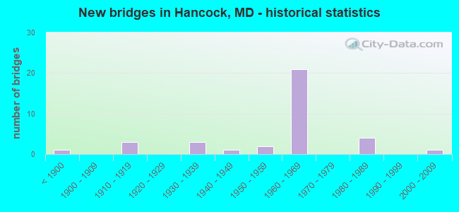
- New bridges - historical statistics
- 1Before 1900
- 31910-1919
- 31930-1939
- 11940-1949
- 21950-1959
- 211960-1969
- 41980-1989
- 12000-2009

- Reconstructed bridges - Historical Statistics
- 21960-1969
- 31970-1979
- 51980-1989
- 51990-1999
- 22000-2009


- Bridge Condition - Deck
- 4.5%Very good
- 45.5%Good
- 22.7%Satisfactory
- 27.3%Fair

- Bridge Condition - Superstructure
- 8.7%Very good
- 21.7%Good
- 39.1%Satisfactory
- 30.4%Fair

- Bridge Condition - Substructure
- 30.4%Good
- 43.5%Satisfactory
- 26.1%Fair

- Bridge Condition - Channel
- 6.3%Very good
- 62.5%Good
- 31.3%Satisfactory

- Bridge Condition - Culverts
- 66.7%Good
- 33.3%Satisfactory
Find on map >> Show street view
Structure Number: 10000021000702, Location: 0.4 MILE EAST OF IS 68 (Lat: 39.699033, Lng: -78.241003), Route carried "on" structure: State highway 144WB, Year Built: 1965, Status: Open, Structure Length: 2.77m (9.09ft), Average Daily Traffic: 972 (year 2009), Truck Traffic: 8%, Average Future Daily Traffic: 1,547 (year 2026), Design Load: H 20, Features Intersected: LITTLE TONOLOWAY CREEK
Minimum Vertical Clearance: 30+ m (98+ ft), Kilometerpoint: 0.740, Lanes on structure: 2, Owner: State Highway Agency, Approaching Roadway Width: 13.4m (44.0ft), Skew: 4 degrees, Material/Design: Concrete, Design/Construction: Culvert, Length of Maximum Span: 3.7m (12.1ft)
Condition: Channel: Satisfactory, Culverts: Good, Operating Rating: 32.7 metric tons, Method Used To Determine Operating Rating: Field evaluation and documented engineering judgment, Inventory Rating: 32.7 metric tons, Method Used To Determine Inventory Rating: Field evaluation and documented engineering judgment, Structural Evaluation: Better than present minimum criteria, Waterway Adequacy: Better than present minimum criteria, Approach Roadway Alignment: Equal to present desirable criteria, Designated Inspection Frequency: Every 24 months, Inspection Date: Febuary 2020
Find on map >> Show street view
Structure Number: 10000021000901, Location: 0.69 MILE WEST OF IS 70 (Lat: 39.695625, Lng: -78.156417), Route carried "on" structure: State highway 144WB, Year Built: 1940, Year Reconstructed: 1988, Status: Open, Structure Length: 9.30m (30.51ft), Average Daily Traffic: 8,201 (year 2009), Truck Traffic: 8%, Average Future Daily Traffic: 10,794 (year 2026), Design Load: HS 20+Mod, Features Intersected: TONOLOWAY CREEK
Minimum Vertical Clearance: 30+ m (98+ ft), Kilometerpoint: 8.496, Lanes on structure: 2, Owner: State Highway Agency, Approaching Roadway Width: 11.0m (36.1ft), Skew: 4 degrees, Material/Design: Steel continuous, Design/Construction: Stringer/Multi-beam, Number Of Spans In Main Unit: 3, Number Of Approach Spans: 2, Length of Maximum Span: 22.9m (75.1ft), Curb-To-Curb Width: 9.8m (32.2ft), Out-to-Out Width: 10.8m (35.4ft)
Condition: Deck: Good, Superstructure: Fair, Substructure: Fair, Channel: Good, Operating Rating: 73.9 metric tons, Method Used To Determine Operating Rating: Load Factor (LF), Inventory Rating: 44.4 metric tons, Method Used To Determine Inventory Rating: Load Factor (LF), Structural Evaluation: Somewhat better than minimum adequacy, Deck Geometry: Meets minimum limits, Waterway Adequacy: Superior to present desirable criteria, Approach Roadway Alignment: Equal to present desirable criteria, Designated Inspection Frequency: Every 24 months, Inspection Date: July 2021, Deck Structure Type: Concrete Cast-file-Place, Wearing Surface/Protective System: Wearing Surface: Monolithic Concrete, Deck Protection: Epoxy Coated Reinforcing
Find on map >> Show street view
Structure Number: 10000021004301, Location: ON WEST VIRGINIA LINE (Lat: 39.690850, Lng: -1.303089), Route carried "on" structure: US 522, Year Built: 1937, Status: Open, Structure Length: 78.55m (257.71ft), Average Daily Traffic: 11,973 (year 2021), Truck Traffic: 8%, Average Future Daily Traffic: 14,369 (year 2043), Design Load: H 20, Features Intersected: POTOMAC RIV, CSX TRANS.
Minimum Vertical Clearance: 30+ m (98+ ft), Kilometerpoint: 0.209, Lanes on structure: 2, Base Highway Network: Yes, Owner: State Highway Agency, Approaching Roadway Width: 10.4m (34.1ft), Skew: 2 degrees, Material/Design: Steel continuous, Design/Construction: Truss - Deck, Number Of Spans In Main Unit: 23, Number Of Approach Spans: 7, Length of Maximum Span: 59.7m (195.9ft), Curb or Sidewalk Widths: Left: 0.9m (3.0ft), Right: 0.9m (3.0ft), Curb-To-Curb Width: 8.2m (26.9ft), Out-to-Out Width: 9.9m (32.5ft)
Condition: Deck: Satisfactory, Superstructure: Fair, Substructure: Fair, Channel: Good, Operating Rating: 41.3 metric tons, Method Used To Determine Operating Rating: Allowable Stress (AS), Inventory Rating: 24.5 metric tons, Method Used To Determine Inventory Rating: Allowable Stress (AS), Structural Evaluation: Somewhat better than minimum adequacy, Deck Geometry: High priority of corrective action, Underclear: Equal to present desirable criteria, Waterway Adequacy: Equal to present desirable criteria, Approach Roadway Alignment: High priority of corrective action, Length Of Structure Improvement: 78.70m (258.20ft), Designated Inspection Frequency: Every 24 months, Critical Feature Inspection Frequency: Every 24 months, Underwater Inspection Frequency: Every 48 months, Inspection Date: July 2021, Critical Feature Inspection Date: July 2021, Underwater Inspection Date: July 2019, Bridge Improvement Cost: $5,035,000, Roadway Improvement Cost: $504,000, Total Project Cost: $5,542,000, Deck Structure Type: Concrete Cast-file-Place, Wearing Surface/Protective System: Wearing Surface: Monolithic Concrete
Find on map >> Show street view
Structure Number: 100000210061043, Location: 2.3 MILES E OF MD 144WB (Lat: 39.684922, Lng: -78.102850), Route carried "on" structure: Interstate 70, Year Built: 1960, Year Reconstructed: 1973, Status: Open, Structure Length: 0.94m (3.08ft), Average Daily Traffic: 34,830 (year 2009), Truck Traffic: 8%, Average Future Daily Traffic: 48,862 (year 2029), Design Load: HS 20, Features Intersected: RAMP E2 FROM MD 615
Minimum Vertical Clearance: 30+ m (98+ ft), Kilometerpoint: 9.416, Lanes on structure: 2, Lanes under structure: 1, Base Highway Network: Yes, Owner: State Highway Agency, Approaching Roadway Width: 11.9m (39.0ft), Material/Design: Concrete, Design/Construction: Frame, Number Of Spans In Main Unit: 1, Length of Maximum Span: 7.9m (25.9ft), Curb-To-Curb Width: 12.2m (40.0ft), Out-to-Out Width: 13.2m (43.3ft)
Condition: Deck: Fair, Superstructure: Fair, Substructure: Good, Operating Rating: 50.3 metric tons, Method Used To Determine Operating Rating: Load Factor (LF), Inventory Rating: 30.4 metric tons, Method Used To Determine Inventory Rating: Load Factor (LF), Structural Evaluation: Somewhat better than minimum adequacy, Deck Geometry: Better than present minimum criteria, Underclear: High priority of corrective action, Approach Roadway Alignment: Equal to present desirable criteria, Designated Inspection Frequency: Every 12 months, Inspection Date: January 2022, Deck Structure Type: Concrete Cast-file-Place, Wearing Surface/Protective System: Wearing Surface: Bituminous
Find on map >> Show street view
Structure Number: 10000021006201, Location: 0.85 MILE E OF MD 144WB (Lat: 39.690306, Lng: -78.128283), Route carried "on" structure: Interstate 70, Year Built: 1960, Year Reconstructed: 1980, Status: Open, Structure Length: 4.51m (14.80ft), Average Daily Traffic: 38,542 (year 2009), Truck Traffic: 8%, Average Future Daily Traffic: 48,862 (year 2029), Design Load: HS 20, Features Intersected: RAMP D2 TO MD 615
Minimum Vertical Clearance: 30+ m (98+ ft), Kilometerpoint: 7.096, Lanes on structure: 2, Lanes under structure: 1, Base Highway Network: Yes, Owner: State Highway Agency, Approaching Roadway Width: 12.2m (40.0ft), Skew: 3 degrees, Material/Design: Steel, Design/Construction: Stringer/Multi-beam, Number Of Spans In Main Unit: 3, Length of Maximum Span: 15.5m (50.9ft), Curb-To-Curb Width: 13.1m (43.0ft), Out-to-Out Width: 14.1m (46.3ft)
Condition: Deck: Satisfactory, Superstructure: Satisfactory, Substructure: Satisfactory, Operating Rating: 62.6 metric tons, Method Used To Determine Operating Rating: Load Factor (LF), Inventory Rating: 37.2 metric tons, Method Used To Determine Inventory Rating: Load Factor (LF), Structural Evaluation: Equal to present minimum criteria, Deck Geometry: Superior to present desirable criteria, Underclear: Meets minimum limits, Approach Roadway Alignment: Equal to present desirable criteria, Designated Inspection Frequency: Every 24 months, Inspection Date: January 2021, Deck Structure Type: Concrete Cast-file-Place, Wearing Surface/Protective System: Wearing Surface: Monolithic Concrete, Deck Protection: Epoxy Coated Reinforcing
Find on map >> Show street view
Structure Number: 10000021006301, Location: 0.3 M E OF BR NO 2109200 (Lat: 39.695647, Lng: -78.150392), Route carried "on" structure: Ramp Interstate 70, Year Built: 1989, Status: Open, Structure Length: 6.95m (22.80ft), Average Daily Traffic: 26,700 (year 2017), Truck Traffic: 8%, Average Future Daily Traffic: 31,820 (year 2037), Design Load: HS 20+Mod, Features Intersected: IS 70 EBR & RAMP 'B'
Minimum Vertical Clearance: 30+ m (98+ ft), Kilometerpoint: 5.133, Lanes on structure: 1, Lanes under structure: 2, Base Highway Network: Yes, Owner: State Highway Agency, Approaching Roadway Width: 8.8m (28.9ft), Skew: 4 degrees, Material/Design: Steel continuous, Design/Construction: Stringer/Multi-beam, Number Of Spans In Main Unit: 2, Length of Maximum Span: 40.8m (133.9ft), Curb-To-Curb Width: 8.8m (28.9ft), Out-to-Out Width: 10.1m (33.1ft)
Condition: Deck: Satisfactory, Superstructure: Satisfactory, Substructure: Satisfactory, Operating Rating: 83.4 metric tons, Method Used To Determine Operating Rating: Load Factor (LF), Inventory Rating: 49.9 metric tons, Method Used To Determine Inventory Rating: Load Factor (LF), Structural Evaluation: Equal to present minimum criteria, Deck Geometry: Superior to present desirable criteria, Underclear: Somewhat better than minimum adequacy, Approach Roadway Alignment: Equal to present minimum criteria, Designated Inspection Frequency: Every 24 months, Inspection Date: March 2021, Deck Structure Type: Concrete Cast-file-Place, Wearing Surface/Protective System: Wearing Surface: Monolithic Concrete, Deck Protection: Epoxy Coated Reinforcing
Find on map >> Show street view
Structure Number: 10000021007002, Location: 1.46 MILES E OF MD 144WB (Lat: 39.712711, Lng: -78.230156), Route carried "on" structure: Interstate 68, Year Built: 1965, Status: Open, Structure Length: 10.39m (34.09ft), Average Daily Traffic: 19,000 (year 2009), Truck Traffic: 8%, Average Future Daily Traffic: 23,118 (year 2026), Design Load: HS 20, Features Intersected: LITTLE TONOLOWAY CREEK
Minimum Vertical Clearance: 30+ m (98+ ft), Kilometerpoint: 10.404, Lanes on structure: 6, Base Highway Network: Yes, Owner: State Highway Agency, Approaching Roadway Width: 39.6m (129.9ft), Material/Design: Concrete, Design/Construction: Culvert, Length of Maximum Span: 4.6m (15.1ft)
Condition: Channel: Satisfactory, Culverts: Good, Operating Rating: 62.1 metric tons, Method Used To Determine Operating Rating: Load Factor (LF), Inventory Rating: 37.2 metric tons, Method Used To Determine Inventory Rating: Load Factor (LF), Structural Evaluation: Better than present minimum criteria, Waterway Adequacy: Better than present minimum criteria, Approach Roadway Alignment: Equal to present desirable criteria, Designated Inspection Frequency: Every 24 months, Inspection Date: Febuary 2020
Find on map >> Show street view
Structure Number: 10000021007101, Location: @ IS 68 (Lat: 39.712722, Lng: -78.229392), Route carried "on" structure: County highway 14, Year Built: 1965, Year Reconstructed: 1978, Status: Open, Structure Length: 12.16m (39.90ft), Average Daily Traffic: 999 (year 1994), Truck Traffic: 5%, Average Future Daily Traffic: 1,178 (year 2012), Design Load: H 20, Features Intersected: IS 68, Facility Carried by Structure: SANDY MILE RD
Minimum Vertical Clearance: 30+ m (98+ ft), Kilometerpoint: 1.689, Lanes on structure: 2, Lanes under structure: 4, Owner: State Highway Agency, Approaching Roadway Width: 11.0m (36.1ft), Material/Design: Steel, Design/Construction: Stringer/Multi-beam, Number Of Spans In Main Unit: 7, Length of Maximum Span: 22.3m (73.2ft), Curb-To-Curb Width: 7.9m (25.9ft), Out-to-Out Width: 9.5m (31.2ft)
Condition: Deck: Satisfactory, Superstructure: Satisfactory, Substructure: Satisfactory, Channel: Good, Operating Rating: 71.7 metric tons, Method Used To Determine Operating Rating: Load Factor (LF), Inventory Rating: 42.6 metric tons, Method Used To Determine Inventory Rating: Load Factor (LF), Structural Evaluation: Equal to present minimum criteria, Deck Geometry: Somewhat better than minimum adequacy, Underclear: Somewhat better than minimum adequacy, Waterway Adequacy: Better than present minimum criteria, Approach Roadway Alignment: Equal to present desirable criteria, Designated Inspection Frequency: Every 24 months, Inspection Date: June 2021, Deck Structure Type: Concrete Cast-file-Place, Wearing Surface/Protective System: Wearing Surface: Bituminous
Find on map >> Show street view
Structure Number: 100000210076013, Location: 1.0 MILE WEST OF IS 70 (Lat: 39.711828, Lng: -78.201842), Route carried "on" structure: Interstate 68, Year Built: 1965, Year Reconstructed: 1978, Status: Open, Structure Length: 4.11m (13.48ft), Average Daily Traffic: 19,000 (year 2009), Truck Traffic: 8%, Average Future Daily Traffic: 11,559 (year 2026), Design Load: HS 20, Features Intersected: CREEK RD
Minimum Vertical Clearance: 30+ m (98+ ft), Kilometerpoint: 12.915, Lanes on structure: 2, Lanes under structure: 2, Base Highway Network: Yes, Owner: State Highway Agency, Approaching Roadway Width: 11.6m (38.1ft), Skew: 4 degrees, Material/Design: Steel, Design/Construction: Stringer/Multi-beam, Number Of Spans In Main Unit: 3, Length of Maximum Span: 18.9m (62.0ft), Curb-To-Curb Width: 11.8m (38.7ft), Out-to-Out Width: 12.4m (40.7ft)
Condition: Deck: Fair, Superstructure: Satisfactory, Substructure: Satisfactory, Operating Rating: 66.7 metric tons, Method Used To Determine Operating Rating: Load Factor (LF), Inventory Rating: 39.9 metric tons, Method Used To Determine Inventory Rating: Load Factor (LF), Structural Evaluation: Equal to present minimum criteria, Deck Geometry: Equal to present minimum criteria, Underclear: Meets minimum limits, Approach Roadway Alignment: Equal to present desirable criteria, Designated Inspection Frequency: Every 24 months, Inspection Date: January 2021, Deck Structure Type: Concrete Cast-file-Place, Wearing Surface/Protective System: Wearing Surface: Bituminous
Find on map >> Show street view
Structure Number: 100000210076014, Location: 1.0 MILE WEST OF IS 70 (Lat: 39.711842, Lng: -78.203236), Route carried "on" structure: Interstate 68, Year Built: 1965, Year Reconstructed: 1978, Status: Open, Structure Length: 4.39m (14.40ft), Average Daily Traffic: 19,000 (year 2009), Truck Traffic: 8%, Average Future Daily Traffic: 11,559 (year 2026), Design Load: HS 20, Features Intersected: CREEK RD
Minimum Vertical Clearance: 30+ m (98+ ft), Kilometerpoint: 12.915, Lanes on structure: 2, Lanes under structure: 2, Base Highway Network: Yes, Owner: State Highway Agency, Approaching Roadway Width: 11.6m (38.1ft), Skew: 4 degrees, Material/Design: Steel, Design/Construction: Stringer/Multi-beam, Number Of Spans In Main Unit: 3, Length of Maximum Span: 18.9m (62.0ft), Curb-To-Curb Width: 11.8m (38.7ft), Out-to-Out Width: 12.4m (40.7ft)
Condition: Deck: Fair, Superstructure: Satisfactory, Substructure: Satisfactory, Operating Rating: 64.9 metric tons, Method Used To Determine Operating Rating: Load Factor (LF), Inventory Rating: 39.0 metric tons, Method Used To Determine Inventory Rating: Load Factor (LF), Structural Evaluation: Equal to present minimum criteria, Deck Geometry: Equal to present minimum criteria, Underclear: Meets minimum limits, Approach Roadway Alignment: Equal to present desirable criteria, Designated Inspection Frequency: Every 24 months, Inspection Date: January 2021, Deck Structure Type: Concrete Cast-file-Place, Wearing Surface/Protective System: Wearing Surface: Bituminous
Find on map >> Show street view
Structure Number: 10000021008701, Location: 0.09 MILE WEST OF US 522A (Lat: 39.713672, Lng: -78.188447), Route carried "on" structure: Interstate 70, Year Built: 1965, Status: Open, Structure Length: 4.33m (14.21ft), Average Daily Traffic: 19,000 (year 2009), Truck Traffic: 25%, Average Future Daily Traffic: 27,096 (year 2026), Design Load: HS 20, Features Intersected: IS 68 RAMP 'D'
Minimum Vertical Clearance: 4.88m (16.01ft), Kilometerpoint: 1.030, Lanes on structure: 2, Lanes under structure: 1, Base Highway Network: Yes, Owner: State Highway Agency, Approaching Roadway Width: 12.2m (40.0ft), Skew: 3 degrees, Material/Design: Steel, Design/Construction: Stringer/Multi-beam, Number Of Spans In Main Unit: 3, Length of Maximum Span: 17.4m (57.1ft), Curb-To-Curb Width: 12.0m (39.4ft), Out-to-Out Width: 13.8m (45.3ft)
Condition: Deck: Satisfactory, Superstructure: Satisfactory, Substructure: Satisfactory, Operating Rating: 76.2 metric tons, Method Used To Determine Operating Rating: Load Factor (LF), Inventory Rating: 45.8 metric tons, Method Used To Determine Inventory Rating: Load Factor (LF), Structural Evaluation: Equal to present minimum criteria, Deck Geometry: Somewhat better than minimum adequacy, Underclear: Somewhat better than minimum adequacy, Approach Roadway Alignment: Equal to present desirable criteria, Designated Inspection Frequency: Every 24 months, Inspection Date: January 2021, Bridge Improvement Cost: $385,000, Roadway Improvement Cost: $38,000, Total Project Cost: $424,000, Deck Structure Type: Concrete Cast-file-Place, Wearing Surface/Protective System: Wearing Surface: Bituminous
Find on map >> Show street view
Structure Number: 10000021008801, Location: 3.78 MILES E OF MD 144WB (Lat: 39.714025, Lng: -78.188897), Route carried "on" structure: Interstate 68, Year Built: 1965, Year Reconstructed: 1974, Status: Open, Structure Length: 7.13m (23.39ft), Average Daily Traffic: 19,780 (year 2017), Truck Traffic: 25%, Average Future Daily Traffic: 12,220 (year 2037), Design Load: HS 20, Features Intersected: IS 70 EBR, IS 68 RAMP 'D
Minimum Vertical Clearance: 30+ m (98+ ft), Kilometerpoint: 14.135, Lanes on structure: 2, Lanes under structure: 2, Base Highway Network: Yes, Owner: State Highway Agency, Approaching Roadway Width: 13.4m (44.0ft), Skew: 2 degrees, Material/Design: Steel, Design/Construction: Stringer/Multi-beam, Number Of Spans In Main Unit: 3, Length of Maximum Span: 25.6m (84.0ft), Curb-To-Curb Width: 8.9m (29.2ft), Out-to-Out Width: 10.7m (35.1ft)
Condition: Deck: Fair, Superstructure: Fair, Substructure: Satisfactory, Operating Rating: 83.4 metric tons, Method Used To Determine Operating Rating: Load Factor (LF), Inventory Rating: 49.9 metric tons, Method Used To Determine Inventory Rating: Load Factor (LF), Structural Evaluation: Somewhat better than minimum adequacy, Deck Geometry: Meets minimum limits, Underclear: Somewhat better than minimum adequacy, Approach Roadway Alignment: Equal to present desirable criteria, Length Of Structure Improvement: 7.13m (23.39ft), Designated Inspection Frequency: Every 24 months, Inspection Date: March 2021, Bridge Improvement Cost: $494,000, Roadway Improvement Cost: $49,000, Total Project Cost: $543,000, Deck Structure Type: Concrete Cast-file-Place, Wearing Surface/Protective System: Wearing Surface: Bituminous
Find on map >> Show street view
Structure Number: 100000210091013, Location: 0.24 MILE EAST OF US 522 (Lat: 39.706214, Lng: -78.180111), Route carried "on" structure: Interstate 70, Year Built: 1965, Year Reconstructed: 1993, Status: Open, Structure Length: 4.63m (15.19ft), Average Daily Traffic: 37,440 (year 2009), Truck Traffic: 25%, Average Future Daily Traffic: 49,260 (year 2029), Design Load: HS 25 or greater, Features Intersected: PENNSYLVANIA AVE
Minimum Vertical Clearance: 30+ m (98+ ft), Kilometerpoint: 2.233, Lanes on structure: 3, Lanes under structure: 2, Base Highway Network: Yes, Owner: State Highway Agency, Approaching Roadway Width: 15.9m (52.2ft), Material/Design: Steel, Design/Construction: Stringer/Multi-beam, Number Of Spans In Main Unit: 3, Length of Maximum Span: 16.5m (54.1ft), Curb-To-Curb Width: 14.4m (47.2ft), Out-to-Out Width: 14.7m (48.2ft)
Condition: Deck: Good, Superstructure: Good, Substructure: Good, Inventory Rating: 56.2 metric tons, Method Used To Determine Inventory Rating: Load Factor (LF), Structural Evaluation: Better than present minimum criteria, Deck Geometry: Meets minimum limits, Underclear: Somewhat better than minimum adequacy, Approach Roadway Alignment: Equal to present desirable criteria, Length Of Structure Improvement: 4.63m (15.19ft), Designated Inspection Frequency: Every 24 months, Inspection Date: January 2022, Bridge Improvement Cost: $440,000, Roadway Improvement Cost: $44,000, Total Project Cost: $484,000, Deck Structure Type: Concrete Cast-file-Place, Wearing Surface/Protective System: Wearing Surface: Bituminous, Deck Protection: Epoxy Coated Reinforcing
Find on map >> Show street view
Structure Number: 100000210091014, Location: 0.24 MILE EAST OF US 522 (Lat: 39.706303, Lng: -78.179539), Route carried "on" structure: Interstate 70, Year Built: 1965, Year Reconstructed: 1993, Status: Open, Structure Length: 4.24m (13.91ft), Average Daily Traffic: 37,440 (year 2009), Truck Traffic: 25%, Average Future Daily Traffic: 49,260 (year 2029), Design Load: HS 25 or greater, Features Intersected: PENNSYLVANIA AVE
Minimum Vertical Clearance: 30+ m (98+ ft), Kilometerpoint: 2.233, Lanes on structure: 2, Lanes under structure: 2, Base Highway Network: Yes, Owner: State Highway Agency, Approaching Roadway Width: 12.8m (42.0ft), Material/Design: Steel, Design/Construction: Stringer/Multi-beam, Number Of Spans In Main Unit: 3, Length of Maximum Span: 14.6m (47.9ft), Curb-To-Curb Width: 12.9m (42.3ft), Out-to-Out Width: 13.8m (45.3ft)
Condition: Deck: Good, Superstructure: Good, Substructure: Good, Inventory Rating: 62.1 metric tons, Method Used To Determine Inventory Rating: Load Factor (LF), Structural Evaluation: Better than present minimum criteria, Deck Geometry: Superior to present desirable criteria, Underclear: Somewhat better than minimum adequacy, Approach Roadway Alignment: Equal to present desirable criteria, Length Of Structure Improvement: 4.24m (13.91ft), Designated Inspection Frequency: Every 24 months, Inspection Date: January 2022, Bridge Improvement Cost: $377,000, Roadway Improvement Cost: $38,000, Total Project Cost: $415,000, Deck Structure Type: Concrete Cast-file-Place, Wearing Surface/Protective System: Wearing Surface: Bituminous, Deck Protection: Epoxy Coated Reinforcing
Find on map >> Show street view
Structure Number: 100000210092013, Location: 0.67 MILE W OF MD 144WB (Lat: 39.699117, Lng: -78.154919), Route carried "on" structure: Interstate 70, Year Built: 1965, Year Reconstructed: 2004, Status: Open, Structure Length: 12.44m (40.81ft), Average Daily Traffic: 19,611 (year 2017), Truck Traffic: 26%, Average Future Daily Traffic: 29,141 (year 2037), Design Load: HS 20, Features Intersected: GR TONOLOWAY CK, CO RDS
Minimum Vertical Clearance: 30+ m (98+ ft), Kilometerpoint: 4.592, Lanes on structure: 2, Lanes under structure: 2, Base Highway Network: Yes, Owner: State Highway Agency, Approaching Roadway Width: 11.6m (38.1ft), Skew: 1 degrees, Material/Design: Steel continuous, Design/Construction: Stringer/Multi-beam, Number Of Spans In Main Unit: 3, Length of Maximum Span: 47.2m (154.9ft), Curb-To-Curb Width: 15.6m (51.2ft), Out-to-Out Width: 16.8m (55.1ft)
Condition: Deck: Good, Superstructure: Satisfactory, Substructure: Good, Channel: Good, Operating Rating: 44.0 metric tons, Method Used To Determine Operating Rating: Load Factor (LF), Inventory Rating: 26.3 metric tons, Method Used To Determine Inventory Rating: Load Factor (LF), Structural Evaluation: Equal to present minimum criteria, Deck Geometry: Superior to present desirable criteria, Underclear: Meets minimum limits, Approach Roadway Alignment: Equal to present desirable criteria, Designated Inspection Frequency: Every 24 months, Inspection Date: July 2020, Deck Structure Type: Concrete Cast-file-Place, Wearing Surface/Protective System: Wearing Surface: Bituminous
Find on map >> Show street view
Structure Number: 100000210092014, Location: 0.67 MILE W OF MD 144WB (Lat: 39.699267, Lng: -78.154447), Route carried "on" structure: Interstate 70, Year Built: 1965, Year Reconstructed: 2004, Status: Open, Structure Length: 15.30m (50.20ft), Average Daily Traffic: 39,222 (year 2017), Truck Traffic: 26%, Average Future Daily Traffic: 58,281 (year 2037), Design Load: HS 20, Features Intersected: GR TONOLOWAY CK, CO RDS
Minimum Vertical Clearance: 30+ m (98+ ft), Kilometerpoint: 4.592, Lanes on structure: 2, Lanes under structure: 2, Base Highway Network: Yes, Owner: State Highway Agency, Approaching Roadway Width: 11.6m (38.1ft), Skew: 1 degrees, Material/Design: Steel continuous, Design/Construction: Stringer/Multi-beam, Number Of Spans In Main Unit: 3, Number Of Approach Spans: 1, Length of Maximum Span: 44.2m (145.0ft), Curb-To-Curb Width: 15.1m (49.5ft), Out-to-Out Width: 16.6m (54.5ft)
Condition: Deck: Good, Superstructure: Satisfactory, Substructure: Satisfactory, Channel: Very good, Operating Rating: 66.7 metric tons, Method Used To Determine Operating Rating: Load Factor (LF), Inventory Rating: 39.9 metric tons, Method Used To Determine Inventory Rating: Load Factor (LF), Structural Evaluation: Equal to present minimum criteria, Deck Geometry: Superior to present desirable criteria, Underclear: Meets minimum limits, Waterway Adequacy: Equal to present desirable criteria, Approach Roadway Alignment: Equal to present desirable criteria, Designated Inspection Frequency: Every 24 months, Inspection Date: July 2020, Deck Structure Type: Concrete Cast-file-Place, Wearing Surface/Protective System: Wearing Surface: Bituminous
Find on map >> Show street view
Structure Number: 10000021012401, Location: 0.03 MILE SOUTH OF MD 894 (Lat: 40.168222, Lng: -78.319414), Route carried "on" structure: US 522, Year Built: 1937, Status: Open, Structure Length: 17.86m (58.60ft), Average Daily Traffic: 11,154 (year 2017), Truck Traffic: 8%, Average Future Daily Traffic: 13,385 (year 2039), Design Load: H 20, Features Intersected: MD 144/WEST MAIN STREET,
Minimum Vertical Clearance: 30+ m (98+ ft), Kilometerpoint: 1.014, Lanes on structure: 2, Lanes under structure: 5, Base Highway Network: Yes, Owner: State Highway Agency, Approaching Roadway Width: 8.5m (27.9ft), Material/Design: Steel continuous, Design/Construction: Stringer/Multi-beam, Number Of Spans In Main Unit: 4, Length of Maximum Span: 48.8m (160.1ft), Curb or Sidewalk Widths: Left: 0.9m (3.0ft), Right: 0.0m, Curb-To-Curb Width: 8.2m (26.9ft), Out-to-Out Width: 9.9m (32.5ft)
Condition: Deck: Fair, Superstructure: Fair, Substructure: Fair, Channel: Good, Operating Rating: 56.7 metric tons, Method Used To Determine Operating Rating: Load Factor (LF), Inventory Rating: 34.9 metric tons, Method Used To Determine Inventory Rating: Load Factor (LF), Structural Evaluation: Somewhat better than minimum adequacy, Deck Geometry: High priority of corrective action, Underclear: High priority of corrective action, Waterway Adequacy: Superior to present desirable criteria, Approach Roadway Alignment: Equal to present desirable criteria, Length Of Structure Improvement: 17.86m (58.60ft), Designated Inspection Frequency: Every 12 months, Critical Feature Inspection Frequency: Every 12 months, Inspection Date: July 2021, Critical Feature Inspection Date: July 2021, Bridge Improvement Cost: $1,143,000, Roadway Improvement Cost: $114,000, Total Project Cost: $1,257,000, Deck Structure Type: Concrete Cast-file-Place, Wearing Surface/Protective System: Wearing Surface: Monolithic Concrete
Find on map >> Show street view
Structure Number: 10000021015101, Location: 3.58 MILE WEST OF US 522 (Lat: 39.697739, Lng: -78.246814), Route carried "on" structure: State highway 144WB, Year Built: 1987, Status: Open, Structure Length: 7.59m (24.90ft), Average Daily Traffic: 972 (year 2009), Truck Traffic: 8%, Average Future Daily Traffic: 1,547 (year 2026), Design Load: HS 20, Features Intersected: IS 68
Minimum Vertical Clearance: 30+ m (98+ ft), Kilometerpoint: 0.097, Lanes on structure: 2, Lanes under structure: 5, Owner: State Highway Agency, Approaching Roadway Width: 12.8m (42.0ft), Material/Design: Steel continuous, Design/Construction: Stringer/Multi-beam, Number Of Spans In Main Unit: 3, Length of Maximum Span: 29.3m (96.1ft), Curb-To-Curb Width: 11.6m (38.1ft), Out-to-Out Width: 12.6m (41.3ft)
Condition: Deck: Good, Superstructure: Satisfactory, Substructure: Good, Operating Rating: 55.8 metric tons, Method Used To Determine Operating Rating: Load Factor (LF), Inventory Rating: 33.6 metric tons, Method Used To Determine Inventory Rating: Load Factor (LF), Structural Evaluation: Equal to present minimum criteria, Deck Geometry: Better than present minimum criteria, Approach Roadway Alignment: Equal to present desirable criteria, Designated Inspection Frequency: Every 24 months, Inspection Date: August 2020, Deck Structure Type: Concrete Cast-file-Place, Wearing Surface/Protective System: Wearing Surface: Monolithic Concrete, Deck Protection: Epoxy Coated Reinforcing
Find on map >> Show street view
Structure Number: 10000021015703, Location: 0.01 M W OF PENNSYLVANIA (Lat: 39.720011, Lng: -77.543533), Route carried "on" structure: State highway 418, Year Built: 1958, Status: Open, Structure Length: 0.64m (2.10ft), Average Daily Traffic: 5,880 (year 2009), Truck Traffic: 8%, Average Future Daily Traffic: 6,849 (year 2026), Features Intersected: TRIB TO RED RUN
Minimum Vertical Clearance: 30+ m (98+ ft), Kilometerpoint: 7.417, Lanes on structure: 2, Owner: State Highway Agency, Approaching Roadway Width: 13.4m (44.0ft), Material/Design: Steel, Design/Construction: Culvert, Length of Maximum Span: 2.4m (7.9ft), Curb-To-Curb Width: 13.4m (44.0ft), Out-to-Out Width: 18.3m (60.0ft)
Condition: Channel: Satisfactory, Culverts: Satisfactory, Structural Evaluation: Equal to present minimum criteria, Deck Geometry: Equal to present minimum criteria, Waterway Adequacy: Equal to present desirable criteria, Approach Roadway Alignment: Equal to present desirable criteria, Designated Inspection Frequency: Every 24 months, Inspection Date: May 2021
Find on map >> Show street view
Structure Number: 200000W-002201, Location: 0.08 MI E OF ALL-WASH CO (Lat: 39.700389, Lng: -78.316367), Route carried "on" structure: County highway 2, Year Built: 1916, Year Reconstructed: 1995, Status: Open, Structure Length: 0.72m (2.36ft), Average Daily Traffic: 176 (year 2019), Truck Traffic: 5%, Average Future Daily Traffic: 294 (year 2039), Design Load: HS 25 or greater, Features Intersected: BEAR CREEK, Facility Carried by Structure: McFARLAND ROAD
Minimum Vertical Clearance: 30+ m (98+ ft), Kilometerpoint: 2.108, Lanes on structure: 2, Owner: County Highway Agency, Approaching Roadway Width: 7.9m (25.9ft), Skew: 3 degrees, Material/Design: Wood or Timber, Design/Construction: Stringer/Multi-beam, Number Of Spans In Main Unit: 1, Length of Maximum Span: 6.7m (22.0ft), Curb-To-Curb Width: 7.3m (24.0ft), Out-to-Out Width: 7.9m (25.9ft)
Condition: Deck: Good, Superstructure: Good, Substructure: Fair, Channel: Satisfactory, Operating Rating: 61.2 metric tons, Method Used To Determine Operating Rating: Allowable Stress (AS), Inventory Rating: 42.6 metric tons, Method Used To Determine Inventory Rating: Allowable Stress (AS), Structural Evaluation: Somewhat better than minimum adequacy, Deck Geometry: Somewhat better than minimum adequacy, Waterway Adequacy: Superior to present desirable criteria, Approach Roadway Alignment: Equal to present desirable criteria, Designated Inspection Frequency: Every 24 months, Underwater Inspection Frequency: Every 48 months, Inspection Date: November 2021, Underwater Inspection Date: November 2019, Deck Structure Type: Wood or Timber, Wearing Surface/Protective System: Wearing Surface: Bituminous, Membrane: Other, Deck Protection: Other
Find on map >> Show street view
Structure Number: 200000W-021101, Location: ON ALLEGANY CO LINE (Lat: 39.649575, Lng: -78.344022), Route carried "on" structure: County highway 734, Year Built: 1890, Year Reconstructed: 2002, Status: Open, Structure Length: 3.34m (10.96ft), Average Daily Traffic: 66 (year 2015), Truck Traffic: 5%, Average Future Daily Traffic: 91 (year 2037), Design Load: HS 20, Features Intersected: SIDELING HILL CREEK, Facility Carried by Structure: PEARRE ROAD
Minimum Vertical Clearance: 30+ m (98+ ft), Kilometerpoint: 4.023, Lanes on structure: 1, Owner: County Highway Agency, Approaching Roadway Width: 4.3m (14.1ft), Material/Design: Steel, Design/Construction: Girder and Floorbeam System, Number Of Spans In Main Unit: 3, Length of Maximum Span: 16.8m (55.1ft), Curb-To-Curb Width: 4.6m (15.1ft), Out-to-Out Width: 4.9m (16.1ft)
Condition: Deck: Good, Superstructure: Fair, Substructure: Fair, Channel: Good, Operating Rating: 74.8 metric tons, Method Used To Determine Operating Rating: Load Factor (LF), Inventory Rating: 44.9 metric tons, Method Used To Determine Inventory Rating: Load Factor (LF), Structural Evaluation: Somewhat better than minimum adequacy, Deck Geometry: Better than present minimum criteria, Waterway Adequacy: Equal to present desirable criteria, Approach Roadway Alignment: High priority of corrective action, Designated Inspection Frequency: Every 24 months, Critical Feature Inspection Frequency: Every 24 months, Inspection Date: November 2021, Critical Feature Inspection Date: November 2021, Deck Structure Type: Open Grating
Find on map >> Show street view
Structure Number: 200000W-023101, Location: 0.19 MI S OF MD 144 (Lat: 39.695192, Lng: -78.244039), Route carried "on" structure: County highway 23, Year Built: 1918, Year Reconstructed: 1989, Status: Open, Structure Length: 0.70m (2.30ft), Average Daily Traffic: 377 (year 2008), Truck Traffic: 5%, Average Future Daily Traffic: 649 (year 2030), Design Load: HS 20, Features Intersected: LITTLE TONOLOWAY CREEK, Facility Carried by Structure: WOODMONT ROAD
Minimum Vertical Clearance: 30+ m (98+ ft), Kilometerpoint: 9.911, Lanes on structure: 2, Owner: County Highway Agency, Approaching Roadway Width: 5.5m (18.0ft), Skew: 2 degrees, Material/Design: Concrete, Design/Construction: Slab, Number Of Spans In Main Unit: 1, Length of Maximum Span: 6.1m (20.0ft), Curb-To-Curb Width: 7.8m (25.6ft), Out-to-Out Width: 8.0m (26.2ft)
Condition: Deck: Good, Superstructure: Good, Substructure: Fair, Channel: Good, Inventory Rating: 59.9 metric tons, Method Used To Determine Inventory Rating: Load Factor (LF), Structural Evaluation: Somewhat better than minimum adequacy, Deck Geometry: Somewhat better than minimum adequacy, Waterway Adequacy: Superior to present desirable criteria, Approach Roadway Alignment: Better than present minimum criteria, Designated Inspection Frequency: Every 24 months, Inspection Date: November 2021, Deck Structure Type: Concrete Cast-file-Place, Wearing Surface/Protective System: Wearing Surface: Bituminous, Deck Protection: Epoxy Coated Reinforcing
Find on map >> Show street view
Structure Number: 200000W-038101, Location: 0.6 MI E OF MD 144 (Lat: 39.698439, Lng: -78.155869), Route carried "on" structure: County highway 38, Year Built: 1916, Year Reconstructed: 2005, Status: Open, Structure Length: 1.78m (5.84ft), Average Daily Traffic: 765 (year 2019), Truck Traffic: 5%, Average Future Daily Traffic: 985 (year 2039), Features Intersected: TONOLOWAY CREEK, Facility Carried by Structure: TOLLGATE RIDGE RD
Minimum Vertical Clearance: 30+ m (98+ ft), Kilometerpoint: 1.062, Lanes on structure: 2, Owner: County Highway Agency, Approaching Roadway Width: 8.8m (28.9ft), Material/Design: Concrete, Design/Construction: Arch - Deck, Number Of Spans In Main Unit: 1, Length of Maximum Span: 16.8m (55.1ft), Curb-To-Curb Width: 7.6m (24.9ft), Out-to-Out Width: 8.2m (26.9ft)
Condition: Superstructure: Good, Substructure: Good, Channel: Good, Structural Evaluation: Better than present minimum criteria, Deck Geometry: Meets minimum limits, Waterway Adequacy: Equal to present minimum criteria, Approach Roadway Alignment: Equal to present desirable criteria, Designated Inspection Frequency: Every 24 months, Underwater Inspection Frequency: Every 48 months, Inspection Date: November 2021, Underwater Inspection Date: November 2019, Wearing Surface/Protective System: Wearing Surface: Bituminous
Find on map >> Show street view
Structure Number: 200000W-HA0101, Location: 0.16 MI N MD RT 144 (Lat: 39.701400, Lng: -78.188753), Route carried "on" structure: County highway , Year Built: 1950, Year Reconstructed: 2005, Status: Open, Structure Length: 1.28m (4.20ft), Average Daily Traffic: 116 (year 2018), Truck Traffic: 5%, Average Future Daily Traffic: 200 (year 2038), Features Intersected: LITTLE TONOLOWAY CREEK, Facility Carried by Structure: PARK ROAD 2
Minimum Vertical Clearance: 30+ m (98+ ft), Kilometerpoint: 0.000, Lanes on structure: 1, Owner: Town or Township Highway Agency, Approaching Roadway Width: 4.6m (15.1ft), Material/Design: Steel, Design/Construction: Stringer/Multi-beam, Number Of Spans In Main Unit: 1, Length of Maximum Span: 11.3m (37.1ft), Curb-To-Curb Width: 5.0m (16.4ft), Out-to-Out Width: 5.5m (18.0ft)
Condition: Deck: Fair, Superstructure: Fair, Substructure: Satisfactory, Channel: Satisfactory, Operating Rating: 21.2 metric tons, Method Used To Determine Operating Rating: Load Factor (LF), Inventory Rating: 12.8 metric tons, Method Used To Determine Inventory Rating: Load Factor (LF), Structural Evaluation: Meets minimum limits, Deck Geometry: High priority of replacement, Waterway Adequacy: Equal to present minimum criteria, Approach Roadway Alignment: Equal to present desirable criteria, Bridge Posting: Required (Relationship of Operating Rating to Maximum Legal Load: 30.0 - 39.9% below), Designated Inspection Frequency: Every 24 months, Critical Feature Inspection Frequency: Every 24 months, Other Special Inspection Frequency: Every 12 months, Inspection Date: Febuary 2020, Critical Feature Inspection Date: Febuary 2020, Other Special Inspection Date: Febuary 2021, Deck Structure Type: Concrete Cast-file-Place, Wearing Surface/Protective System: Wearing Surface: Bituminous
Find on map >> Show street view
Structure Number: 200000W-HA0201, Location: 0.76 MI. W OF US 40 (Lat: 39.707975, Lng: -78.199736), Route carried "on" structure: State lands road , Year Built: 2008, Status: Open, Structure Length: 1.91m (6.27ft), Average Daily Traffic: 50 (year 2018), Truck Traffic: 1%, Average Future Daily Traffic: 86 (year 2038), Design Load: HS 20, Features Intersected: LITTLE TONOLOWAY CREEK, Facility Carried by Structure: KIRK WOODS PARK RO
Minimum Vertical Clearance: 30+ m (98+ ft), Kilometerpoint: 0.000, Lanes on structure: 1, Owner: Town or Township Highway Agency, Approaching Roadway Width: 4.9m (16.1ft), Material/Design: Steel, Design/Construction: Stringer/Multi-beam, Number Of Spans In Main Unit: 1, Length of Maximum Span: 18.0m (59.1ft), Curb-To-Curb Width: 4.9m (16.1ft), Out-to-Out Width: 5.4m (17.7ft)
Condition: Deck: Good, Superstructure: Very good, Substructure: Good, Channel: Good, Operating Rating: 71.2 metric tons, Method Used To Determine Operating Rating: Load Factor (LF), Inventory Rating: 42.6 metric tons, Method Used To Determine Inventory Rating: Load Factor (LF), Structural Evaluation: Better than present minimum criteria, Deck Geometry: High priority of corrective action, Waterway Adequacy: Superior to present desirable criteria, Approach Roadway Alignment: Equal to present minimum criteria, Designated Inspection Frequency: Every 24 months, Inspection Date: Febuary 2020, Deck Structure Type: Other
Find on map >> Show street view
Structure Number: 3100011P, Location: 0.2 miles from Little Ton (Lat: 39.698250, Lng: -78.182806), Route carried "on" structure: Spur Federal lands road 207, Year Built: 1969, Year Reconstructed: 2002, Status: Closed, Structure Length: 1.28m (4.20ft), Average Daily Traffic: 72 (year 2007), Truck Traffic: 1%, Average Future Daily Traffic: 79 (year 2027), Design Load: H 15, Features Intersected: C&O CANAL, Facility Carried by Structure: LITTLE TONOLOWAY A
Minimum Vertical Clearance: 30+ m (98+ ft), Kilometerpoint: 199.881, Lanes on structure: 1, Owner: National Park Service, Approaching Roadway Width: 3.7m (12.1ft), Material/Design: Steel, Design/Construction: Stringer/Multi-beam, Number Of Spans In Main Unit: 1, Length of Maximum Span: 12.2m (40.0ft), Curb-To-Curb Width: 3.0m (9.8ft), Out-to-Out Width: 3.7m (12.1ft)
Condition: Deck: Very good, Superstructure: Very good, Substructure: Satisfactory, Channel: Good, Operating Rating: 4.5 metric tons, Method Used To Determine Operating Rating: Load Factor (LF), Inventory Rating: 4.5 metric tons, Method Used To Determine Inventory Rating: Load Factor (LF), Waterway Adequacy: Equal to present desirable criteria, Approach Roadway Alignment: Equal to present desirable criteria, Bridge Posting: Required (Relationship of Operating Rating to Maximum Legal Load: > 39.9% below), Designated Inspection Frequency: Every 24 months, Inspection Date: October 2021, Deck Structure Type: Wood or Timber
Find on map >> Show street view
Structure Number: 10000021004301, Location: ON WEST VIRGINIA LNE (Lat: 39.690850, Lng: -78.186053), Route carried "under" structure: City street 30, Year Built: 1937, Structure Length: 0. m, Average Daily Traffic: 150 (year 2012), Features Intersected: POTOMAC RIV, CSX TRANS, Facility Carried by Structure: US 522
Minimum Vertical Clearance: 9.14m (29.99ft), Kilometerpoint: 0.467, Lanes on structure: 2, Material/Design: Steel continuous, Design/Construction: Truss - Deck, Length of Maximum Span: 59.7m (195.9ft)
Find on map >> Show street view
Structure Number: 100000210061043, Location: 2.34 MILES E OF MD 144WB (Lat: 39.684922, Lng: -78.102850), Route carried "under" structure: Ramp State highway 615, Year Built: 1960, Structure Length: 0. m, Average Daily Traffic: 23,800 (year 2012), Features Intersected: RAMP E2 FROM MD 615, Facility Carried by Structure: IS 70 EB
Minimum Vertical Clearance: 6.40m (21.00ft), Kilometerpoint: 2.944, Lanes on structure: 2, Lanes under structure: 1, Material/Design: Concrete, Design/Construction: Frame, Length of Maximum Span: 7.9m (25.9ft)
Find on map >> Show street view
Structure Number: 10000021006201, Location: 0.88 MI E OF MD 144WB (Lat: 39.690306, Lng: -78.128283), Route carried "under" structure: Ramp State highway 70, Year Built: 1960, Structure Length: 0. m, Average Daily Traffic: 23,800 (year 2012), Features Intersected: RAMP TO MD 615
Minimum Vertical Clearance: 4.88m (16.01ft), Kilometerpoint: 2.896, Lanes on structure: 2, Lanes under structure: 1, Material/Design: Steel, Design/Construction: Stringer/Multi-beam, Length of Maximum Span: 15.5m (50.9ft)
Find on map >> Show street view
Structure Number: 10000021006301, Location: 0.3 M E OF BR NO 2109200 (Lat: 39.695631, Lng: -78.150414), Route carried "under" structure: Interstate 70, Year Built: 1989, Structure Length: 0. m, Average Daily Traffic: 37,440 (year 2009), Features Intersected: IS 70 EBR & RAMP 'B'
Minimum Vertical Clearance: 4.88m (16.01ft), Kilometerpoint: 5.133, Lanes on structure: 1, Lanes under structure: 2, Material/Design: Steel continuous, Design/Construction: Stringer/Multi-beam, Length of Maximum Span: 40.8m (133.9ft)
Find on map >> Show street view
Structure Number: 10000021007101, Location: 0.02 M E OF BR NO 2107000 (Lat: 39.712722, Lng: -78.229392), Route carried "under" structure: Interstate 68, Year Built: 1965, Structure Length: 0. m, Average Daily Traffic: 19,000 (year 2009), Features Intersected: IS 68, Facility Carried by Structure: SANDY MILE RD
Minimum Vertical Clearance: 5.49m (18.01ft), Kilometerpoint: 10.587, Lanes on structure: 2, Lanes under structure: 4, Material/Design: Steel, Design/Construction: Stringer/Multi-beam, Length of Maximum Span: 22.3m (73.2ft)
Find on map >> Show street view
Structure Number: 10000021008701, Location: 0.16 MILE WEST OF IS 70 (Lat: 39.713672, Lng: -78.188447), Route carried "under" structure: Ramp Interstate 68, Year Built: 1965, Structure Length: 0. m, Average Daily Traffic: 41,250 (year 2009), Truck Traffic: 8%, Features Intersected: IS 68 RAMP 'D', Facility Carried by Structure: IS 70 EBR
Minimum Vertical Clearance: 4.88m (16.01ft), Kilometerpoint: 14.288, Lanes on structure: 2, Lanes under structure: 1, Material/Design: Steel, Design/Construction: Stringer/Multi-beam, Length of Maximum Span: 17.4m (57.1ft)
Find on map >> Show street view
Structure Number: 10000021008801, Location: 3.67 MILES E OF MD 144WB (Lat: 39.713775, Lng: -78.188164), Route carried "under" structure: Interstate 70, Year Built: 1965, Structure Length: 0. m, Average Daily Traffic: 41,250 (year 2009), Truck Traffic: 8%, Features Intersected: IS 70 EBR,IS 68 RAMP 'D', Facility Carried by Structure: IS 68 WBR
Minimum Vertical Clearance: 4.88m (16.01ft), Kilometerpoint: 1.014, Lanes on structure: 2, Lanes under structure: 2, Material/Design: Steel, Design/Construction: Stringer/Multi-beam, Length of Maximum Span: 25.6m (84.0ft)
Find on map >> Show street view
Structure Number: 100000210091013, Location: 0.24 MI E OF US 522 (Lat: 39.706214, Lng: -78.180111), Route carried "under" structure: City street 280, Year Built: 1965, Structure Length: 0. m, Average Daily Traffic: 999 (year 2012), Features Intersected: PENNSYLVANIA AVE, Facility Carried by Structure: IS 70 EBR
Minimum Vertical Clearance: 7.62m (25.00ft), Kilometerpoint: 0.901, Lanes on structure: 3, Lanes under structure: 2, Material/Design: Steel, Design/Construction: Stringer/Multi-beam, Length of Maximum Span: 16.5m (54.1ft)
Find on map >> Show street view
Structure Number: 100000210091014, Location: 0.24 MI E OF US 522 (Lat: 39.706303, Lng: -78.179539), Route carried "under" structure: City street 280, Year Built: 1965, Structure Length: 0. m, Average Daily Traffic: 999 (year 2012), Features Intersected: PENNSYLVANIA AVE, Facility Carried by Structure: IS 70 WBR
Minimum Vertical Clearance: 7.62m (25.00ft), Kilometerpoint: 0.901, Lanes on structure: 2, Lanes under structure: 2, Material/Design: Steel, Design/Construction: Stringer/Multi-beam, Length of Maximum Span: 14.6m (47.9ft)
Find on map >> Show street view
Structure Number: 10000021015101, Location: 1.85 M E OF BR NO 2114800 (Lat: 39.697739, Lng: -78.246814), Route carried "under" structure: Interstate 68, Year Built: 1987, Structure Length: 0. m, Average Daily Traffic: 19,000 (year 2009), Truck Traffic: 8%, Features Intersected: IS 68, Facility Carried by Structure: MD 144WB
Minimum Vertical Clearance: 5.18m (16.99ft), Kilometerpoint: 8.206, Lanes on structure: 2, Lanes under structure: 5, Material/Design: Steel continuous, Design/Construction: Stringer/Multi-beam, Length of Maximum Span: 29.3m (96.1ft)