Bridge Statistics for Hampshire, Illinois (IL)
Condition, Traffic, Stress, Structural Evaluation, Project Costs
- National Bridge Inventory (NBI) Statistics
- 24Number of bridges
- 154ft / 47.1mTotal length
- 295,925Total average daily traffic
- 70,632Total average daily truck traffic
- National Bridge Inventory (NBI) Registered Bridges for Hampshire
- No street view available for this location
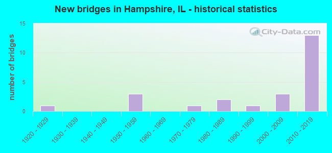
- New bridges - historical statistics
- 11920-1929
- 31950-1959
- 11970-1979
- 21980-1989
- 11990-1999
- 32000-2009
- 132010-2019


- Bridge Condition - Deck
- 20.0%Very good
- 60.0%Good
- 20.0%Satisfactory

- Bridge Condition - Superstructure
- 70.0%Very good
- 10.0%Good
- 20.0%Satisfactory

- Bridge Condition - Substructure
- 50.0%Very good
- 30.0%Good
- 10.0%Satisfactory
- 10.0%Fair

- Bridge Condition - Channel
- 57.1%Very good
- 28.6%Good
- 7.1%Satisfactory
- 7.1%Fair

- Bridge Condition - Culverts
- 22.2%Excellent
- 33.3%Very good
- 22.2%Good
- 11.1%Satisfactory
- 11.1%Fair
Find on map >> Show street view
Structure Number: 450053, Location: 5.3 M W OF IL 47 (Lat: 42.088275, Lng: -88.561528), Route carried "on" structure: State highway 72, Year Built: 1928, Year Reconstructed: 1981, Status: Open, Structure Length: 1.71m (5.61ft), Average Daily Traffic: 7,300 (year 2021), Truck Traffic: 8%, Average Future Daily Traffic: 5,295 (year 2032), Design Load: HS 20, Features Intersected: COON CREEK
Minimum Vertical Clearance: 30+ m (98+ ft), Kilometerpoint: 110.076, Lanes on structure: 2, Base Highway Network: Yes, Owner: State Highway Agency, Approaching Roadway Width: 8.2m (26.9ft), Material/Design: Concrete continuous, Design/Construction: Slab, Number Of Spans In Main Unit: 2, Length of Maximum Span: 8.4m (27.6ft), Curb-To-Curb Width: 9.8m (32.2ft), Out-to-Out Width: 10.7m (35.1ft)
Condition: Deck: Satisfactory, Superstructure: Satisfactory, Substructure: Fair, Channel: Fair, Operating Rating: 61.2 metric tons, Method Used To Determine Operating Rating: Load Factor (LF) rating reported by rating factor (RF) method using MS18 loading, Inventory Rating: 36.9 metric tons, Method Used To Determine Inventory Rating: Load Factor (LF) rating reported by rating factor (RF) method using MS18 loading, Structural Evaluation: Somewhat better than minimum adequacy, Deck Geometry: Meets minimum limits, Waterway Adequacy: Better than present minimum criteria, Approach Roadway Alignment: Equal to present desirable criteria, Designated Inspection Frequency: Every 24 months, Inspection Date: October 2021, Deck Structure Type: Concrete Cast-file-Place, Wearing Surface/Protective System: Wearing Surface: Latex Concrete, Deck Protection: Epoxy Coated Reinforcing
Find on map >> Show street view
Structure Number: 452004, Location: 5.9 M W OF IL 47 (Lat: 42.088264, Lng: -88.571964), Route carried "on" structure: State highway 72, Year Built: 1981, Status: Open, Structure Length: 0.71m (2.33ft), Average Daily Traffic: 5,250 (year 2021), Truck Traffic: 12%, Average Future Daily Traffic: 6,316 (year 2032), Design Load: HS 20, Features Intersected: COON CREEK BRANCH
Minimum Vertical Clearance: 30+ m (98+ ft), Kilometerpoint: 109.207, Lanes on structure: 2, Base Highway Network: Yes, Owner: State Highway Agency, Approaching Roadway Width: 8.2m (26.9ft), Skew: 4 degrees, Material/Design: Concrete continuous, Design/Construction: Culvert, Number Of Spans In Main Unit: 2, Length of Maximum Span: 3.4m (11.2ft), Curb-To-Curb Width: 9.8m (32.2ft), Out-to-Out Width: 10.4m (34.1ft)
Condition: Channel: Good, Culverts: Satisfactory, Operating Rating: 52.2 metric tons, Method Used To Determine Operating Rating: Load Factor (LF) rating reported by rating factor (RF) method using MS18 loading, Inventory Rating: 32.4 metric tons, Method Used To Determine Inventory Rating: Load Factor (LF) rating reported by rating factor (RF) method using MS18 loading, Structural Evaluation: Equal to present minimum criteria, Deck Geometry: Meets minimum limits, Waterway Adequacy: Better than present minimum criteria, Approach Roadway Alignment: Equal to present desirable criteria, Designated Inspection Frequency: Every 24 months, Inspection Date: Febuary 2022, Deck Structure Type: Concrete Cast-file-Place, Wearing Surface/Protective System: Deck Protection: Epoxy Coated Reinforcing
Find on map >> Show street view
Structure Number: 452017, Location: 1.2 M W US-20 (Lat: 42.148511, Lng: -88.528311), Route carried "on" structure: Interstate 90, Year Built: 1958, Status: Open, Structure Length: 0.74m (2.43ft), Average Daily Traffic: 46,600 (year 2020), Truck Traffic: 25%, Average Future Daily Traffic: 58,186 (year 2032), Design Load: HS 20, Features Intersected: STREAM
Minimum Vertical Clearance: 30+ m (98+ ft), Kilometerpoint: 66.191, Lanes on structure: 4, Base Highway Network: Yes, Toll: On toll road, Owner: State Toll Authority, Approaching Roadway Width: 36.6m (120.1ft), Skew: 3 degrees, Design/Construction: Culvert, Number Of Spans In Main Unit: 1, Length of Maximum Span: 7.1m (23.3ft)
Condition: Channel: Very good, Culverts: Good, Operating Rating: 62.9 metric tons, Method Used To Determine Operating Rating: Load and Resistance Factor Rating (LRFR) rating reported by rating factor(RF) method using HL-93 loadings, Inventory Rating: 37.6 metric tons, Method Used To Determine Inventory Rating: Load and Resistance Factor Rating (LRFR) rating reported by rating factor(RF) method using HL-93 loadings, Structural Evaluation: Better than present minimum criteria, Waterway Adequacy: Equal to present desirable criteria, Approach Roadway Alignment: Equal to present desirable criteria, Designated Inspection Frequency: Every 24 months, Inspection Date: July 2019
Find on map >> Show street view
Structure Number: 4521, Location: .01M S of Mchenry Co (Lat: 42.153669, Lng: -88.517914), Route carried "on" structure: US 20, Year Built: 2019, Status: Open, Structure Length: 1.14m (3.74ft), Average Daily Traffic: 10,400 (year 2021), Truck Traffic: 27%, Average Future Daily Traffic: 13,850 (year 2043), Design Load: HS 25 or greater, Features Intersected: HAMPSHIRE CREEK
Minimum Vertical Clearance: 30+ m (98+ ft), Kilometerpoint: 205.363, Lanes on structure: 2, Base Highway Network: Yes, Owner: State Highway Agency, Approaching Roadway Width: 13.4m (44.0ft), Skew: 1 degrees, Material/Design: Concrete continuous, Design/Construction: Culvert, Number Of Spans In Main Unit: 3, Length of Maximum Span: 4.0m (13.1ft)
Condition: Channel: Good, Culverts: Excellent, Operating Rating: 75.5 metric tons, Method Used To Determine Operating Rating: Load and Resistance Factor Rating (LRFR) rating reported by rating factor(RF) method using HL-93 loadings, Inventory Rating: 58.3 metric tons, Method Used To Determine Inventory Rating: Load and Resistance Factor Rating (LRFR) rating reported by rating factor(RF) method using HL-93 loadings, Structural Evaluation: Superior to present desirable criteria, Waterway Adequacy: Better than present minimum criteria, Approach Roadway Alignment: Equal to present desirable criteria, Designated Inspection Frequency: Every 24 months, Inspection Date: January 2021
Find on map >> Show street view
Structure Number: 452101, Location: 1.2 M S of I-90 (Lat: 42.129717, Lng: -88.490353), Route carried "on" structure: US 20, Year Built: 2019, Status: Open, Structure Length: 0.75m (2.46ft), Average Daily Traffic: 5,200 (year 2021), Truck Traffic: 14%, Average Future Daily Traffic: 5,707 (year 2039), Design Load: HS 25 or greater, Features Intersected: EAKIN CREEK
Minimum Vertical Clearance: 30+ m (98+ ft), Kilometerpoint: 208.919, Lanes on structure: 2, Base Highway Network: Yes, Owner: State Highway Agency, Approaching Roadway Width: 13.4m (44.0ft), Material/Design: Concrete continuous, Design/Construction: Culvert, Number Of Spans In Main Unit: 2, Length of Maximum Span: 3.8m (12.5ft)
Condition: Channel: Good, Culverts: Excellent, Operating Rating: 57.0 metric tons, Method Used To Determine Operating Rating: Load and Resistance Factor Rating (LRFR) rating reported by rating factor(RF) method using HL-93 loadings, Inventory Rating: 44.1 metric tons, Method Used To Determine Inventory Rating: Load and Resistance Factor Rating (LRFR) rating reported by rating factor(RF) method using HL-93 loadings, Structural Evaluation: Superior to present desirable criteria, Waterway Adequacy: Equal to present minimum criteria, Approach Roadway Alignment: Equal to present desirable criteria, Designated Inspection Frequency: Every 24 months, Inspection Date: June 2020
Find on map >> Show street view
Structure Number: 453065, Location: 2 MI W HAMPSHIRE (Lat: 42.107906, Lng: -88.568867), Route carried "on" structure: County highway , Year Built: 2015, Status: Open, Structure Length: 2.29m (7.51ft), Average Daily Traffic: 900 (year 2018), Truck Traffic: 17%, Average Future Daily Traffic: 1,212 (year 2032), Design Load: HS 25 or greater, Features Intersected: BURLINGTON CREEK, Facility Carried by Structure: WALKER ROAD
Minimum Vertical Clearance: 30+ m (98+ ft), Kilometerpoint: 0.241, Lanes on structure: 2, Owner: County Highway Agency, Approaching Roadway Width: 9.8m (32.2ft), Skew: 3 degrees, Material/Design: Concrete, Design/Construction: Stringer/Multi-beam, Number Of Spans In Main Unit: 3, Length of Maximum Span: 21.8m (71.5ft), Curb-To-Curb Width: 9.8m (32.2ft), Out-to-Out Width: 9.8m (32.2ft)
Condition: Deck: Good, Superstructure: Very good, Substructure: Very good, Channel: Very good, Operating Rating: 52.8 metric tons, Method Used To Determine Operating Rating: Load and Resistance Factor Rating (LRFR) rating reported by rating factor(RF) method using HL-93 loadings, Inventory Rating: 40.8 metric tons, Method Used To Determine Inventory Rating: Load and Resistance Factor Rating (LRFR) rating reported by rating factor(RF) method using HL-93 loadings, Structural Evaluation: Equal to present desirable criteria, Deck Geometry: Equal to present minimum criteria, Waterway Adequacy: Equal to present desirable criteria, Approach Roadway Alignment: Equal to present desirable criteria, Designated Inspection Frequency: Every 48 months, Inspection Date: March 2021, Deck Structure Type: Concrete Cast-file-Place, Wearing Surface/Protective System: Deck Protection: Epoxy Coated Reinforcing
Find on map >> Show street view
Structure Number: 453072, Location: 0.9 MI S ILL 72 (Lat: 42.075778, Lng: -88.544608), Route carried "on" structure: Other road , Year Built: 2015, Status: Open, Structure Length: 2.31m (7.58ft), Average Daily Traffic: 1,800 (year 2018), Truck Traffic: 10%, Average Future Daily Traffic: 3,254 (year 2032), Design Load: HS 25 or greater, Features Intersected: BURLINGTON CREEK, Facility Carried by Structure: FRENCH ROAD
Minimum Vertical Clearance: 30+ m (98+ ft), Kilometerpoint: 1.384, Lanes on structure: 2, Base Highway Network: Yes, Owner: County Highway Agency, Approaching Roadway Width: 12.2m (40.0ft), Skew: 1 degrees, Material/Design: Steel, Design/Construction: Stringer/Multi-beam, Number Of Spans In Main Unit: 1, Length of Maximum Span: 22.0m (72.2ft), Curb-To-Curb Width: 12.2m (40.0ft), Out-to-Out Width: 12.2m (40.0ft)
Condition: Deck: Good, Superstructure: Very good, Substructure: Very good, Channel: Very good, Operating Rating: 58.0 metric tons, Method Used To Determine Operating Rating: Load and Resistance Factor Rating (LRFR) rating reported by rating factor(RF) method using HL-93 loadings, Inventory Rating: 44.7 metric tons, Method Used To Determine Inventory Rating: Load and Resistance Factor Rating (LRFR) rating reported by rating factor(RF) method using HL-93 loadings, Structural Evaluation: Equal to present desirable criteria, Deck Geometry: Better than present minimum criteria, Waterway Adequacy: Equal to present desirable criteria, Approach Roadway Alignment: Equal to present desirable criteria, Designated Inspection Frequency: Every 48 months, Inspection Date: March 2021, Deck Structure Type: Concrete Cast-file-Place
Find on map >> Show street view
Structure Number: 453119, Location: 4 MI NW HAMPSHIRE (Lat: 42.144794, Lng: -88.573989), Route carried "on" structure: County highway , Year Built: 1982, Status: Open, Structure Length: 1.41m (4.63ft), Average Daily Traffic: 75 (year 2020), Truck Traffic: 67%, Average Future Daily Traffic: 96 (year 2032), Design Load: HS 20, Features Intersected: HARMONY CREEK, Facility Carried by Structure: OBRIEN ROAD
Minimum Vertical Clearance: 30+ m (98+ ft), Kilometerpoint: 0.982, Lanes on structure: 2, Owner: Town or Township Highway Agency, Approaching Roadway Width: 6.7m (22.0ft), Skew: 1 degrees, Material/Design: Prestressed concrete, Design/Construction: Box Beam or Girders - Multiple, Number Of Spans In Main Unit: 1, Length of Maximum Span: 13.4m (44.0ft), Curb-To-Curb Width: 8.2m (26.9ft), Out-to-Out Width: 8.2m (26.9ft)
Condition: Deck: Satisfactory, Superstructure: Satisfactory, Substructure: Good, Channel: Good, Operating Rating: 64.5 metric tons, Method Used To Determine Operating Rating: Load Factor (LF) rating reported by rating factor (RF) method using MS18 loading, Inventory Rating: 38.6 metric tons, Method Used To Determine Inventory Rating: Load Factor (LF) rating reported by rating factor (RF) method using MS18 loading, Structural Evaluation: Equal to present minimum criteria, Deck Geometry: Equal to present minimum criteria, Waterway Adequacy: Equal to present desirable criteria, Approach Roadway Alignment: Equal to present desirable criteria, Designated Inspection Frequency: Every 24 months, Inspection Date: April 2021, Deck Structure Type: Concrete Precast Panels
Find on map >> Show street view
Structure Number: 453149, Location: NE SEC19,T42N,R6E (Lat: 42.110064, Lng: -88.573525), Route carried "on" structure: County highway , Year Built: 1999, Status: Open, Structure Length: 2.29m (7.51ft), Average Daily Traffic: 325 (year 2018), Truck Traffic: 6%, Average Future Daily Traffic: 702 (year 2032), Design Load: HS 20, Features Intersected: COON CK, Facility Carried by Structure: ALLEN RD
Minimum Vertical Clearance: 30+ m (98+ ft), Kilometerpoint: 1.223, Lanes on structure: 2, Owner: County Highway Agency, Approaching Roadway Width: 11.6m (38.1ft), Skew: 3 degrees, Material/Design: Prestressed concrete, Design/Construction: Box Beam or Girders - Multiple, Number Of Spans In Main Unit: 3, Length of Maximum Span: 7.6m (24.9ft), Curb-To-Curb Width: 9.1m (29.9ft), Out-to-Out Width: 9.8m (32.2ft)
Condition: Deck: Good, Superstructure: Good, Substructure: Good, Channel: Very good, Operating Rating: 64.5 metric tons, Method Used To Determine Operating Rating: Load Factor (LF) rating reported by rating factor (RF) method using MS18 loading, Inventory Rating: 38.6 metric tons, Method Used To Determine Inventory Rating: Load Factor (LF) rating reported by rating factor (RF) method using MS18 loading, Structural Evaluation: Better than present minimum criteria, Deck Geometry: Equal to present minimum criteria, Waterway Adequacy: Equal to present desirable criteria, Approach Roadway Alignment: Equal to present desirable criteria, Designated Inspection Frequency: Every 48 months, Inspection Date: January 2018, Deck Structure Type: Concrete Precast Panels, Wearing Surface/Protective System: Wearing Surface: Integral Concrete, Deck Protection: Epoxy Coated Reinforcing
Find on map >> Show street view
Structure Number: 453175, Location: .5MI N OF ALLEN RD (Lat: 42.131047, Lng: -88.535017), Route carried "on" structure: Other road , Year Built: 2008, Status: Open, Structure Length: 0.83m (2.72ft), Average Daily Traffic: 1,450 (year 2018), Truck Traffic: 19%, Average Future Daily Traffic: 2,807 (year 2032), Design Load: HS 20, Features Intersected: TRIB HAMPSHIRE CREEK, Facility Carried by Structure: HARMONY ROAD
Minimum Vertical Clearance: 30+ m (98+ ft), Kilometerpoint: 2.511, Lanes on structure: 2, Owner: County Highway Agency, Approaching Roadway Width: 9.8m (32.2ft), Material/Design: Concrete, Design/Construction: Culvert, Number Of Spans In Main Unit: 3, Length of Maximum Span: 2.7m (8.9ft)
Condition: Channel: Very good, Culverts: Good, Operating Rating: 88.8 metric tons, Method Used To Determine Operating Rating: Load Factor (LF) rating reported by rating factor (RF) method using MS18 loading, Inventory Rating: 88.8 metric tons, Method Used To Determine Inventory Rating: Load Factor (LF) rating reported by rating factor (RF) method using MS18 loading, Structural Evaluation: Better than present minimum criteria, Waterway Adequacy: Equal to present desirable criteria, Approach Roadway Alignment: Equal to present desirable criteria, Designated Inspection Frequency: Every 48 months, Inspection Date: Febuary 2019
Find on map >> Show street view
Structure Number: 453185, Location: 1 Mi W of Hamshire (Lat: 42.106522, Lng: -88.554700), Route carried "on" structure: County highway , Year Built: 2016, Status: Open, Structure Length: 0.95m (3.12ft), Average Daily Traffic: 750 (year 2018), Truck Traffic: 15%, Average Future Daily Traffic: 3,381 (year 2032), Design Load: HS 25 or greater, Features Intersected: Hamshire Creek, Facility Carried by Structure: Allen Road
Minimum Vertical Clearance: 30+ m (98+ ft), Kilometerpoint: 2.961, Lanes on structure: 2, Owner: County Highway Agency, Approaching Roadway Width: 10.4m (34.1ft), Skew: 4 degrees, Material/Design: Concrete, Design/Construction: Culvert, Number Of Spans In Main Unit: 2, Length of Maximum Span: 4.6m (15.1ft), Curb-To-Curb Width: 10.4m (34.1ft)
Condition: Channel: Very good, Culverts: Very good, Operating Rating: 80.0 metric tons, Method Used To Determine Operating Rating: Load and Resistance Factor Rating (LRFR) rating reported by rating factor(RF) method using HL-93 loadings, Inventory Rating: 61.9 metric tons, Method Used To Determine Inventory Rating: Load and Resistance Factor Rating (LRFR) rating reported by rating factor(RF) method using HL-93 loadings, Structural Evaluation: Equal to present desirable criteria, Deck Geometry: Equal to present minimum criteria, Waterway Adequacy: Superior to present desirable criteria, Approach Roadway Alignment: Equal to present minimum criteria, Designated Inspection Frequency: Every 48 months, Inspection Date: May 2018
Find on map >> Show street view
Structure Number: 455007, Location: 2.6 MI NW HAMPSHIRE (Lat: 42.122544, Lng: -88.569078), Route carried "on" structure: County highway , Year Built: 1977, Status: Open, Structure Length: 0.90m (2.95ft), Average Daily Traffic: 800 (year 2018), Truck Traffic: 10%, Average Future Daily Traffic: 1,085 (year 2032), Design Load: HS 20, Features Intersected: HAMPSHIRE CREEK, Facility Carried by Structure: WALKER RD
Minimum Vertical Clearance: 30+ m (98+ ft), Kilometerpoint: 1.030, Lanes on structure: 2, Owner: Town or Township Highway Agency, Approaching Roadway Width: 7.3m (24.0ft), Skew: 3 degrees, Material/Design: Concrete, Design/Construction: Culvert, Number Of Spans In Main Unit: 2, Length of Maximum Span: 3.7m (12.1ft), Curb-To-Curb Width: 10.4m (34.1ft), Out-to-Out Width: 11.0m (36.1ft)
Condition: Channel: Satisfactory, Culverts: Fair, Operating Rating: 54.4 metric tons, Method Used To Determine Operating Rating: Load Factor (LF) rating reported by rating factor (RF) method using MS18 loading, Inventory Rating: 32.4 metric tons, Method Used To Determine Inventory Rating: Load Factor (LF) rating reported by rating factor (RF) method using MS18 loading, Structural Evaluation: Somewhat better than minimum adequacy, Deck Geometry: Equal to present minimum criteria, Waterway Adequacy: Equal to present desirable criteria, Approach Roadway Alignment: Equal to present desirable criteria, Designated Inspection Frequency: Every 24 months, Inspection Date: March 2021, Deck Structure Type: Other
Find on map >> Show street view
Structure Number: 459926, Location: 1.7 M S MCHENRY CO L (Lat: 42.144428, Lng: -88.514403), Route carried "on" structure: Other road , Year Built: 1958, Status: Open, Structure Length: 6.95m (22.80ft), Average Daily Traffic: 1,450 (year 2020), Average Future Daily Traffic: 2,042 (year 2032), Design Load: HS 20, Features Intersected: I90 (NW TOLL), Facility Carried by Structure: I90 EB ON-OFF RP
Minimum Vertical Clearance: 30+ m (98+ ft), Kilometerpoint: 0.322, Lanes on structure: 2, Lanes under structure: 4, Base Highway Network: Yes (Inventory Route: 10090040, Subroute: 80), Owner: State Toll Authority, Approaching Roadway Width: 9.8m (32.2ft), Skew: 20 degrees, Material/Design: Prestressed concrete, Design/Construction: Stringer/Multi-beam, Number Of Spans In Main Unit: 4, Length of Maximum Span: 24.4m (80.1ft), Curb-To-Curb Width: 9.8m (32.2ft), Out-to-Out Width: 11.3m (37.1ft)
Condition: Deck: Good, Superstructure: Very good, Substructure: Good, Operating Rating: 65.4 metric tons, Method Used To Determine Operating Rating: Load Factor (LF) rating reported by rating factor (RF) method using MS18 loading, Inventory Rating: 39.5 metric tons, Method Used To Determine Inventory Rating: Load Factor (LF) rating reported by rating factor (RF) method using MS18 loading, Structural Evaluation: Better than present minimum criteria, Deck Geometry: Somewhat better than minimum adequacy, Underclear: High priority of corrective action, Approach Roadway Alignment: Equal to present desirable criteria, Designated Inspection Frequency: Every 24 months, Inspection Date: July 2019, Deck Structure Type: Concrete Cast-file-Place
Find on map >> Show street view
Structure Number: 459932, Location: 4 MI W OF IL 47 (Lat: 42.142564, Lng: -88.507008), Route carried "on" structure: Interstate 90, Year Built: 2013, Status: Open, Structure Length: 3.78m (12.40ft), Average Daily Traffic: 24,150 (year 2020), Truck Traffic: 25%, Average Future Daily Traffic: 31,900 (year 2032), Design Load: HS 25 or greater, Features Intersected: US 20
Minimum Vertical Clearance: 30+ m (98+ ft), Kilometerpoint: 68.089, Lanes on structure: 2, Lanes under structure: 4, Base Highway Network: Yes, Toll: On toll road, Owner: State Toll Authority, Approaching Roadway Width: 20.1m (65.9ft), Skew: 13 degrees, Material/Design: Steel, Design/Construction: Stringer/Multi-beam, Number Of Spans In Main Unit: 1, Length of Maximum Span: 36.6m (120.1ft), Curb-To-Curb Width: 20.1m (65.9ft), Out-to-Out Width: 21.0m (68.9ft)
Condition: Deck: Very good, Superstructure: Very good, Substructure: Very good, Operating Rating: 69.7 metric tons, Method Used To Determine Operating Rating: Load and Resistance Factor Rating (LRFR) rating reported by rating factor(RF) method using HL-93 loadings, Inventory Rating: 53.8 metric tons, Method Used To Determine Inventory Rating: Load and Resistance Factor Rating (LRFR) rating reported by rating factor(RF) method using HL-93 loadings, Structural Evaluation: Equal to present desirable criteria, Deck Geometry: Superior to present desirable criteria, Underclear: High priority of corrective action, Approach Roadway Alignment: Equal to present desirable criteria, Designated Inspection Frequency: Every 24 months, Inspection Date: July 2019, Deck Structure Type: Concrete Cast-file-Place, Wearing Surface/Protective System: Deck Protection: Epoxy Coated Reinforcing
Find on map >> Show street view
Structure Number: 459934, Location: 4 MI W IL 47 (Lat: 42.142353, Lng: -88.506158), Route carried "on" structure: Interstate 90, Year Built: 2014, Status: Open, Structure Length: 3.78m (12.40ft), Average Daily Traffic: 24,150 (year 2020), Truck Traffic: 25%, Average Future Daily Traffic: 88,900 (year 2040), Design Load: HS 25 or greater, Features Intersected: US 20
Minimum Vertical Clearance: 30+ m (98+ ft), Kilometerpoint: 68.170, Lanes on structure: 2, Lanes under structure: 4, Base Highway Network: Yes, Toll: On toll road, Owner: State Toll Authority, Approaching Roadway Width: 20.1m (65.9ft), Skew: 3 degrees, Material/Design: Steel, Design/Construction: Stringer/Multi-beam, Number Of Spans In Main Unit: 1, Length of Maximum Span: 36.6m (120.1ft), Curb-To-Curb Width: 20.1m (65.9ft), Out-to-Out Width: 21.0m (68.9ft)
Condition: Deck: Good, Superstructure: Very good, Substructure: Very good, Operating Rating: 69.7 metric tons, Method Used To Determine Operating Rating: Load and Resistance Factor Rating (LRFR) rating reported by rating factor(RF) method using HL-93 loadings, Inventory Rating: 53.8 metric tons, Method Used To Determine Inventory Rating: Load and Resistance Factor Rating (LRFR) rating reported by rating factor(RF) method using HL-93 loadings, Structural Evaluation: Equal to present desirable criteria, Deck Geometry: Superior to present desirable criteria, Approach Roadway Alignment: Equal to present desirable criteria, Designated Inspection Frequency: Every 24 months, Inspection Date: July 2019, Deck Structure Type: Concrete Cast-file-Place, Wearing Surface/Protective System: Deck Protection: Epoxy Coated Reinforcing
Find on map >> Show street view
Structure Number: 459966, Location: I-90 1.4M E of US 20 (Lat: 42.136467, Lng: -88.481667), Route carried "on" structure: Other road , Year Built: 2013, Status: Open, Structure Length: 7.36m (24.15ft), Average Daily Traffic: 625 (year 2018), Truck Traffic: 3%, Average Future Daily Traffic: 829 (year 2032), Design Load: HS 25 or greater, Features Intersected: Interstate 90, Facility Carried by Structure: Brier Hill Road
Minimum Vertical Clearance: 30+ m (98+ ft), Kilometerpoint: 1.094, Lanes on structure: 4, Lanes under structure: 2, Owner: City or Municipal Highway Agency, Approaching Roadway Width: 10.4m (34.1ft), Skew: 1 degrees, Material/Design: Steel continuous, Design/Construction: Stringer/Multi-beam, Number Of Spans In Main Unit: 2, Length of Maximum Span: 36.3m (119.1ft), Curb-To-Curb Width: 10.4m (34.1ft), Out-to-Out Width: 11.4m (37.4ft)
Condition: Deck: Very good, Superstructure: Very good, Substructure: Very good, Operating Rating: 47.3 metric tons, Method Used To Determine Operating Rating: Load and Resistance Factor Rating (LRFR) rating reported by rating factor(RF) method using HL-93 loadings, Inventory Rating: 36.6 metric tons, Method Used To Determine Inventory Rating: Load and Resistance Factor Rating (LRFR) rating reported by rating factor(RF) method using HL-93 loadings, Structural Evaluation: Equal to present desirable criteria, Deck Geometry: High priority of replacement, Underclear: Equal to present minimum criteria, Approach Roadway Alignment: Equal to present desirable criteria, Designated Inspection Frequency: Every 24 months, Inspection Date: August 2020, Deck Structure Type: Concrete Cast-file-Place, Wearing Surface/Protective System: Deck Protection: Epoxy Coated Reinforcing
Find on map >> Show street view
Structure Number: 459967, Location: I-90 1M W of US 20 (Lat: 42.150600, Lng: -88.535319), Route carried "on" structure: Other road , Year Built: 2014, Status: Open, Structure Length: 7.62m (25.00ft), Average Daily Traffic: 1,950 (year 2018), Truck Traffic: 12%, Average Future Daily Traffic: 2,807 (year 2032), Design Load: HS 25 or greater, Features Intersected: Interstate 90, Facility Carried by Structure: Harmony Road
Minimum Vertical Clearance: 30+ m (98+ ft), Kilometerpoint: 0.290, Lanes on structure: 2, Lanes under structure: 4, Owner: County Highway Agency, Approaching Roadway Width: 10.4m (34.1ft), Skew: 2 degrees, Material/Design: Concrete continuous, Design/Construction: Stringer/Multi-beam, Number Of Spans In Main Unit: 2, Length of Maximum Span: 37.5m (123.0ft), Curb-To-Curb Width: 10.4m (34.1ft), Out-to-Out Width: 11.4m (37.4ft)
Condition: Deck: Good, Superstructure: Very good, Substructure: Satisfactory, Operating Rating: 66.1 metric tons, Method Used To Determine Operating Rating: Load and Resistance Factor Rating (LRFR) rating reported by rating factor(RF) method using HL-93 loadings, Inventory Rating: 39.9 metric tons, Method Used To Determine Inventory Rating: Load and Resistance Factor Rating (LRFR) rating reported by rating factor(RF) method using HL-93 loadings, Structural Evaluation: Equal to present minimum criteria, Deck Geometry: Equal to present minimum criteria, Underclear: Somewhat better than minimum adequacy, Approach Roadway Alignment: Equal to present desirable criteria, Designated Inspection Frequency: Every 24 months, Inspection Date: August 2020, Deck Structure Type: Concrete Cast-file-Place, Wearing Surface/Protective System: Deck Protection: Epoxy Coated Reinforcing
Find on map >> Show street view
Structure Number: 563185, Location: 0.4 MI W SEEMAN RD (Lat: 42.165531, Lng: -88.502600), Route carried "on" structure: County highway , Year Built: 2005, Status: Open, Structure Length: 0.84m (2.76ft), Average Daily Traffic: 100 (year 2021), Truck Traffic: 15%, Average Future Daily Traffic: 119 (year 2032), Design Load: HS 20, Features Intersected: UNAMED TRIB COON CRK, Facility Carried by Structure: MUSGRAVE PARKWAY
Minimum Vertical Clearance: 30+ m (98+ ft), Kilometerpoint: 0.290, Lanes on structure: 2, Owner: Town or Township Highway Agency, Approaching Roadway Width: 8.5m (27.9ft), Skew: 1 degrees, Material/Design: Concrete, Design/Construction: Culvert, Number Of Spans In Main Unit: 3, Length of Maximum Span: 2.4m (7.9ft)
Condition: Channel: Very good, Culverts: Very good, Operating Rating: 62.2 metric tons, Method Used To Determine Operating Rating: Load Factor (LF) rating reported by rating factor (RF) method using MS18 loading, Inventory Rating: 37.3 metric tons, Method Used To Determine Inventory Rating: Load Factor (LF) rating reported by rating factor (RF) method using MS18 loading, Structural Evaluation: Equal to present desirable criteria, Waterway Adequacy: Superior to present desirable criteria, Approach Roadway Alignment: Equal to present desirable criteria, Designated Inspection Frequency: Every 48 months, Inspection Date: October 2018
Find on map >> Show street view
Structure Number: 563186, Location: 0.4 MI W SEEMAN RD (Lat: 42.160319, Lng: -88.504775), Route carried "on" structure: County highway , Year Built: 2004, Status: Open, Structure Length: 0.72m (2.36ft), Average Daily Traffic: 350 (year 2021), Truck Traffic: 9%, Average Future Daily Traffic: 130 (year 2032), Design Load: HS 20, Features Intersected: UNAMED TRIB COON CRK, Facility Carried by Structure: BOTTERMAN ROAD
Minimum Vertical Clearance: 30+ m (98+ ft), Kilometerpoint: 0.064, Lanes on structure: 2, Owner: Town or Township Highway Agency, Approaching Roadway Width: 8.5m (27.9ft), Skew: 3 degrees, Material/Design: Concrete, Design/Construction: Culvert, Number Of Spans In Main Unit: 3, Length of Maximum Span: 1.8m (5.9ft)
Condition: Channel: Very good, Culverts: Very good, Operating Rating: 64.8 metric tons, Method Used To Determine Operating Rating: Load Factor (LF) rating reported by rating factor (RF) method using MS18 loading, Inventory Rating: 38.9 metric tons, Method Used To Determine Inventory Rating: Load Factor (LF) rating reported by rating factor (RF) method using MS18 loading, Structural Evaluation: Equal to present desirable criteria, Waterway Adequacy: Superior to present desirable criteria, Approach Roadway Alignment: Equal to present desirable criteria, Designated Inspection Frequency: Every 48 months, Inspection Date: October 2018
Find on map >> Show street view
Structure Number: 459926, Location: 1.7 M S MCHENRY CO L (Lat: 42.144428, Lng: -88.514403), Route carried "under" structure: Interstate 90, Year Built: 1958, Structure Length: 0. m, Average Daily Traffic: 46,600 (year 2020), Truck Traffic: 25%, Features Intersected: I90 (NW TOLL)
Minimum Vertical Clearance: 4.72m (15.49ft), Kilometerpoint: 67.365, Lanes on structure: 2, Lanes under structure: 4, Material/Design: Prestressed concrete, Design/Construction: Stringer/Multi-beam, Length of Maximum Span: 24.4m (80.1ft)
Find on map >> Show street view
Structure Number: 459932, Location: 4 MI W OF IL 47 (Lat: 42.142906, Lng: -88.506892), Route carried "under" structure: US 20, Year Built: 2013, Structure Length: 0. m, Average Daily Traffic: 10,400 (year 2021), Truck Traffic: 27%, Features Intersected: US 20, Facility Carried by Structure: I-90 EB
Minimum Vertical Clearance: 4.70m (15.42ft), Kilometerpoint: 206.876, Lanes on structure: 2, Lanes under structure: 4, Toll: On toll road, Material/Design: Steel, Design/Construction: Stringer/Multi-beam, Length of Maximum Span: 36.6m (120.1ft)
Find on map >> Show street view
Structure Number: 459934, Location: 4 MI W IL 47 (Lat: 42.142736, Lng: -88.506808), Route carried "under" structure: US 20, Year Built: 2014, Structure Length: 0. m, Average Daily Traffic: 10,400 (year 2021), Truck Traffic: 27%, Features Intersected: US 20, Facility Carried by Structure: I 90 WB
Minimum Vertical Clearance: 5.36m (17.59ft), Kilometerpoint: 206.892, Lanes on structure: 2, Lanes under structure: 4, Toll: On toll road, Material/Design: Steel, Design/Construction: Stringer/Multi-beam, Length of Maximum Span: 36.6m (120.1ft)
Find on map >> Show street view
Structure Number: 459966, Location: I-90 1.4M E of US 20 (Lat: 42.136250, Lng: -88.481661), Route carried "under" structure: Interstate 90, Year Built: 2013, Structure Length: 0. m, Average Daily Traffic: 48,300 (year 2020), Truck Traffic: 25%, Features Intersected: Interstate 90, Facility Carried by Structure: Brier Hill Road
Minimum Vertical Clearance: 5.26m (17.26ft), Kilometerpoint: 70.310, Lanes on structure: 4, Lanes under structure: 2, Material/Design: Steel continuous, Design/Construction: Stringer/Multi-beam, Length of Maximum Span: 36.3m (119.1ft)
Find on map >> Show street view
Structure Number: 459967, Location: I-90 1M W of US 20 (Lat: 42.150600, Lng: -88.535319), Route carried "under" structure: Interstate 90, Year Built: 2014, Structure Length: 0. m, Average Daily Traffic: 46,600 (year 2020), Truck Traffic: 25%, Features Intersected: Interstate 90, Facility Carried by Structure: Harmony Road
Minimum Vertical Clearance: 5.00m (16.40ft), Kilometerpoint: 65.595, Lanes on structure: 2, Lanes under structure: 4, Material/Design: Concrete continuous, Design/Construction: Stringer/Multi-beam, Length of Maximum Span: 37.5m (123.0ft)