Bridge Statistics for Hamlin, New York (NY)
Condition, Traffic, Stress, Structural Evaluation, Project Costs
- National Bridge Inventory (NBI) Statistics
- 26Number of bridges
- 177ft / 54.3mTotal length
- $35,291,000Total costs
- 30,794Total average daily traffic
- 1,006Total average daily truck traffic
- National Bridge Inventory (NBI) Registered Bridges for Hamlin
- No street view available for this location

- New bridges - historical statistics
- 11910-1919
- 11920-1929
- 51930-1939
- 31940-1949
- 21950-1959
- 21960-1969
- 71970-1979
- 21980-1989
- 31990-1999
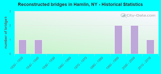
- Reconstructed bridges - Historical Statistics
- 11930-1939
- 11940-1949
- 01950-1959
- 01960-1969
- 01970-1979
- 01980-1989
- 21990-1999
- 22000-2009
- 12010-2019
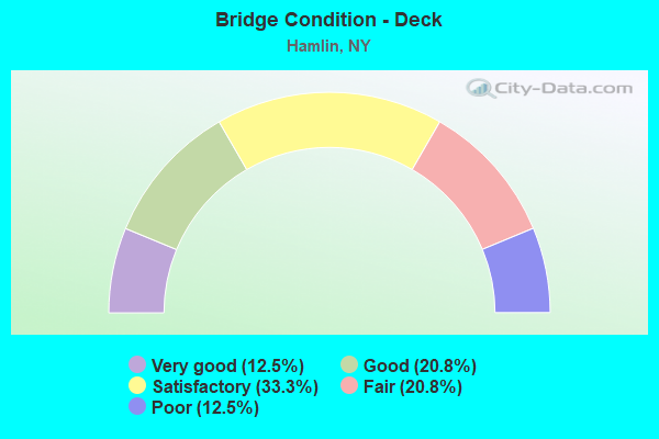
- Bridge Condition - Deck
- 12.5%Very good
- 20.8%Good
- 33.3%Satisfactory
- 20.8%Fair
- 12.5%Poor
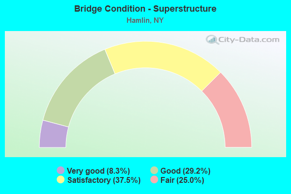
- Bridge Condition - Superstructure
- 8.3%Very good
- 29.2%Good
- 37.5%Satisfactory
- 25.0%Fair
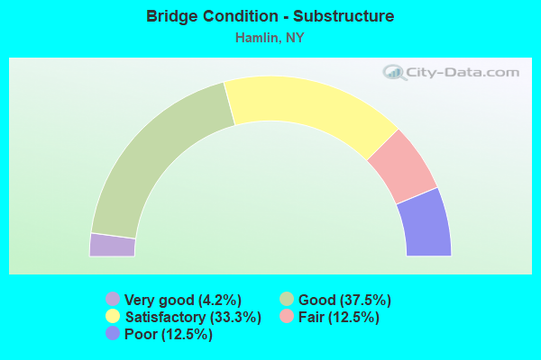
- Bridge Condition - Substructure
- 4.2%Very good
- 37.5%Good
- 33.3%Satisfactory
- 12.5%Fair
- 12.5%Poor
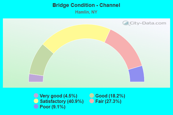
- Bridge Condition - Channel
- 4.5%Very good
- 18.2%Good
- 40.9%Satisfactory
- 27.3%Fair
- 9.1%Poor
Find on map >> Show street view
Structure Number: 101476, Location: JCT RTE 18 & SANDY CREEK (Lat: 43.296436, Lng: -77.964539), Route carried "on" structure: State highway 18, Year Built: 1984, Status: Open, Structure Length: 3.29m (10.79ft), Average Daily Traffic: 2,019 (year 2017), Truck Traffic: 6%, Average Future Daily Traffic: 2,106 (year 2040), Design Load: HS 20, Features Intersected: SANDY CREEK
Minimum Vertical Clearance: 30+ m (98+ ft), Kilometerpoint: 2.751, Lanes on structure: 2, Base Highway Network: Yes, Owner: State Highway Agency, Approaching Roadway Width: 12.2m (40.0ft), Skew: 1 degrees, Material/Design: Prestressed concrete, Design/Construction: Box Beam or Girders - Multiple, Number Of Spans In Main Unit: 1, Length of Maximum Span: 31.6m (103.7ft), Curb-To-Curb Width: 12.2m (40.0ft), Out-to-Out Width: 12.9m (42.3ft)
Condition: Deck: Poor, Superstructure: Satisfactory, Substructure: Satisfactory, Channel: Satisfactory, Operating Rating: 82.6 metric tons, Method Used To Determine Operating Rating: Load Factor (LF), Inventory Rating: 31.8 metric tons, Method Used To Determine Inventory Rating: Load Factor (LF), Structural Evaluation: Equal to present minimum criteria, Deck Geometry: Equal to present minimum criteria, Waterway Adequacy: Meets minimum limits, Approach Roadway Alignment: Equal to present desirable criteria, Length Of Structure Improvement: 3.29m (10.79ft), Designated Inspection Frequency: Every 24 months, Inspection Date: July 2020, Bridge Improvement Cost: $1,128,000, Roadway Improvement Cost: $661,000, Total Project Cost: $1,788,000 ( Estimate for 2021), Deck Structure Type: Concrete Cast-file-Place, Wearing Surface/Protective System: Wearing Surface: Bituminous
Find on map >> Show street view
Structure Number: 101477, Location: 1.9MI W JCT RTS 18 & 19 (Lat: 43.295708, Lng: -77.959042), Route carried "on" structure: State highway 18, Year Built: 1931, Status: Open, Structure Length: 0.76m (2.49ft), Average Daily Traffic: 2,019 (year 2017), Truck Traffic: 6%, Average Future Daily Traffic: 2,106 (year 2040), Features Intersected: SCHWIND CREEK
Minimum Vertical Clearance: 30+ m (98+ ft), Kilometerpoint: 3.218, Lanes on structure: 2, Base Highway Network: Yes, Owner: State Highway Agency, Approaching Roadway Width: 7.9m (25.9ft), Material/Design: Concrete, Design/Construction: Slab, Number Of Spans In Main Unit: 1, Length of Maximum Span: 6.7m (22.0ft), Curb-To-Curb Width: 7.9m (25.9ft), Out-to-Out Width: 8.7m (28.5ft)
Condition: Deck: Fair, Superstructure: Fair, Substructure: Good, Channel: Fair, Operating Rating: 69.9 metric tons, Method Used To Determine Operating Rating: Load Factor (LF), Inventory Rating: 41.7 metric tons, Method Used To Determine Inventory Rating: Load Factor (LF), Structural Evaluation: Somewhat better than minimum adequacy, Deck Geometry: High priority of corrective action, Waterway Adequacy: Meets minimum limits, Approach Roadway Alignment: Equal to present minimum criteria, Length Of Structure Improvement: 0.76m (2.49ft), Designated Inspection Frequency: Every 24 months, Inspection Date: September 2021, Bridge Improvement Cost: $306,000, Roadway Improvement Cost: $179,000, Total Project Cost: $484,000 ( Estimate for 2021), Wearing Surface/Protective System: Wearing Surface: Bituminous
Find on map >> Show street view
Structure Number: 101531, Location: 3.2 MI N OF HAMLIN CENTER (Lat: 43.340542, Lng: -77.900847), Route carried "on" structure: County highway 19, Year Built: 1959, Year Reconstructed: 2016, Status: Open, Structure Length: 3.84m (12.60ft), Average Daily Traffic: 1,352 (year 2020), Truck Traffic: 4%, Average Future Daily Traffic: 1,360 (year 2040), Design Load: HL 93, Features Intersected: SANDY CREEK
Minimum Vertical Clearance: 30+ m (98+ ft), Kilometerpoint: 23.813, Lanes on structure: 2, Base Highway Network: Yes, Owner: State Highway Agency, Approaching Roadway Width: 8.5m (27.9ft), Material/Design: Steel continuous, Design/Construction: Stringer/Multi-beam, Number Of Spans In Main Unit: 2, Length of Maximum Span: 18.8m (61.7ft), Curb-To-Curb Width: 8.5m (27.9ft), Out-to-Out Width: 9.5m (31.2ft)
Condition: Deck: Very good, Superstructure: Very good, Substructure: Good, Channel: Good, Inventory Rating: 84.4 metric tons, Method Used To Determine Inventory Rating: Load Factor (LF), Structural Evaluation: Better than present minimum criteria, Deck Geometry: Somewhat better than minimum adequacy, Waterway Adequacy: Somewhat better than minimum adequacy, Approach Roadway Alignment: Equal to present desirable criteria, Length Of Structure Improvement: 3.84m (12.60ft), Designated Inspection Frequency: Every 24 months, Inspection Date: September 2020, Bridge Improvement Cost: $1,108,000, Roadway Improvement Cost: $649,000, Total Project Cost: $1,757,000 ( Estimate for 2021), Deck Structure Type: Concrete Cast-file-Place, Wearing Surface/Protective System: Wearing Surface: Integral Concrete, Deck Protection: Epoxy Coated Reinforcing
Find on map >> Show street view
Structure Number: 1035841, Location: 8 MI W JCT WB LOSP+RTE261 (Lat: 43.355500, Lng: -77.940164), Route carried "on" structure: State highway 947A, Year Built: 1936, Status: Open, Structure Length: 1.25m (4.10ft), Average Daily Traffic: 1,216 (year 2020), Truck Traffic: 2%, Average Future Daily Traffic: 1,223 (year 2040), Design Load: HS 20, Features Intersected: YANTY CREEK
Minimum Vertical Clearance: 30+ m (98+ ft), Kilometerpoint: 4.795, Lanes on structure: 3, Base Highway Network: Yes, Owner: State Highway Agency, Approaching Roadway Width: 15.5m (50.9ft), Material/Design: Concrete, Design/Construction: Frame, Number Of Spans In Main Unit: 1, Length of Maximum Span: 11.0m (36.1ft), Curb or Sidewalk Widths: Left: 0.4m (1.3ft), Right: 0.4m (1.3ft), Curb-To-Curb Width: 15.2m (49.9ft), Out-to-Out Width: 17.0m (55.8ft)
Condition: Deck: Fair, Superstructure: Fair, Substructure: Satisfactory, Channel: Satisfactory, Operating Rating: 80.4 metric tons, Method Used To Determine Operating Rating: Field evaluation and documented engineering judgment, Inventory Rating: 32.7 metric tons, Method Used To Determine Inventory Rating: Field evaluation and documented engineering judgment, Structural Evaluation: Somewhat better than minimum adequacy, Deck Geometry: Equal to present minimum criteria, Waterway Adequacy: Equal to present minimum criteria, Approach Roadway Alignment: Equal to present desirable criteria, Length Of Structure Improvement: 1.24m (4.07ft), Designated Inspection Frequency: Every 24 months, Inspection Date: June 2021, Bridge Improvement Cost: $714,000, Roadway Improvement Cost: $418,000, Total Project Cost: $1,133,000 ( Estimate for 2021), Wearing Surface/Protective System: Wearing Surface: Bituminous, Membrane: Other
Find on map >> Show street view
Structure Number: 1035842, Location: 8 MI W JCT EB LOSP+RTE261 (Lat: 43.355056, Lng: -77.940225), Route carried "on" structure: State highway 947A, Year Built: 1971, Status: Open, Structure Length: 1.22m (4.00ft), Average Daily Traffic: 1,216 (year 2020), Truck Traffic: 2%, Average Future Daily Traffic: 1,223 (year 2040), Design Load: HS 20, Features Intersected: YANTY CREEK
Minimum Vertical Clearance: 30+ m (98+ ft), Kilometerpoint: 4.795, Lanes on structure: 3, Base Highway Network: Yes, Owner: State Highway Agency, Approaching Roadway Width: 16.5m (54.1ft), Material/Design: Concrete, Design/Construction: Frame, Number Of Spans In Main Unit: 1, Length of Maximum Span: 11.0m (36.1ft), Curb-To-Curb Width: 16.2m (53.1ft), Out-to-Out Width: 17.4m (57.1ft)
Condition: Deck: Satisfactory, Superstructure: Satisfactory, Substructure: Good, Channel: Satisfactory, Operating Rating: 63.5 metric tons, Method Used To Determine Operating Rating: Load Factor (LF), Inventory Rating: 38.1 metric tons, Method Used To Determine Inventory Rating: Load Factor (LF), Structural Evaluation: Equal to present minimum criteria, Deck Geometry: Better than present minimum criteria, Waterway Adequacy: Equal to present minimum criteria, Approach Roadway Alignment: Equal to present desirable criteria, Length Of Structure Improvement: 1.21m (3.97ft), Designated Inspection Frequency: Every 24 months, Inspection Date: June 2021, Bridge Improvement Cost: $798,000, Roadway Improvement Cost: $467,000, Total Project Cost: $1,265,000 ( Estimate for 2021), Wearing Surface/Protective System: Wearing Surface: Bituminous, Membrane: Other
Find on map >> Show street view
Structure Number: 1035869, Location: JCT LOSP+SANDY CREEK (Lat: 43.349828, Lng: -77.893364), Route carried "on" structure: State highway 947A, Year Built: 1950, Year Reconstructed: 1995, Status: Open, Structure Length: 7.25m (23.79ft), Average Daily Traffic: 2,876 (year 2017), Truck Traffic: 2%, Average Future Daily Traffic: 2,893 (year 2040), Design Load: H 20, Features Intersected: SANDY CREEK
Minimum Vertical Clearance: 30+ m (98+ ft), Kilometerpoint: 8.705, Lanes on structure: 4, Base Highway Network: Yes, Owner: State Highway Agency, Approaching Roadway Width: 16.5m (54.1ft), Skew: 31 degrees, Material/Design: Steel, Design/Construction: Stringer/Multi-beam, Number Of Spans In Main Unit: 3, Length of Maximum Span: 30.4m (99.7ft), Curb-To-Curb Width: 18.0m (59.1ft), Out-to-Out Width: 20.7m (67.9ft)
Condition: Deck: Satisfactory, Superstructure: Good, Substructure: Satisfactory, Channel: Very good, Operating Rating: 49.0 metric tons, Method Used To Determine Operating Rating: Load Factor (LF), Inventory Rating: 32.7 metric tons, Method Used To Determine Inventory Rating: Load Factor (LF), Structural Evaluation: Equal to present minimum criteria, Deck Geometry: Somewhat better than minimum adequacy, Waterway Adequacy: Equal to present desirable criteria, Approach Roadway Alignment: Better than present minimum criteria, Length Of Structure Improvement: 7.25m (23.79ft), Designated Inspection Frequency: Every 24 months, Inspection Date: April 2021, Bridge Improvement Cost: $3,704,000, Roadway Improvement Cost: $2,169,000, Total Project Cost: $5,873,000 ( Estimate for 2021), Deck Structure Type: Concrete Cast-file-Place, Wearing Surface/Protective System: Wearing Surface: Integral Concrete, Deck Protection: Epoxy Coated Reinforcing
Find on map >> Show street view
Structure Number: 104132, Location: 3.8MI NW JCT RTS 360+19 (Lat: 43.333506, Lng: -77.965267), Route carried "on" structure: County highway 941P, Year Built: 1946, Status: Open, Structure Length: 0.85m (2.79ft), Average Daily Traffic: 583 (year 2018), Truck Traffic: 7%, Average Future Daily Traffic: 816 (year 2038), Features Intersected: YANTY CREEK
Minimum Vertical Clearance: 30+ m (98+ ft), Kilometerpoint: 12.695, Lanes on structure: 2, Owner: County Highway Agency, Approaching Roadway Width: 6.4m (21.0ft), Skew: 1 degrees, Material/Design: Concrete, Design/Construction: Slab, Number Of Spans In Main Unit: 1, Length of Maximum Span: 7.9m (25.9ft), Curb or Sidewalk Widths: Left: 0.8m (2.6ft), Right: 0.8m (2.6ft), Curb-To-Curb Width: 7.9m (25.9ft), Out-to-Out Width: 10.3m (33.8ft)
Condition: Deck: Satisfactory, Superstructure: Satisfactory, Substructure: Good, Channel: Fair, Operating Rating: 74.4 metric tons, Method Used To Determine Operating Rating: Load Factor (LF), Inventory Rating: 44.5 metric tons, Method Used To Determine Inventory Rating: Load Factor (LF), Structural Evaluation: Equal to present minimum criteria, Deck Geometry: Somewhat better than minimum adequacy, Waterway Adequacy: Equal to present desirable criteria, Approach Roadway Alignment: Meets minimum limits, Length Of Structure Improvement: 0.85m (2.79ft), Designated Inspection Frequency: Every 24 months, Inspection Date: June 2021, Bridge Improvement Cost: $379,000, Roadway Improvement Cost: $222,000, Total Project Cost: $600,000 ( Estimate for 2021), Wearing Surface/Protective System: Wearing Surface: Bituminous
Find on map >> Show street view
Structure Number: 10466, Location: 1 MI E JCT 360 &REDMAN RD (Lat: 43.320969, Lng: -77.940872), Route carried "on" structure: County highway 360, Year Built: 1995, Status: Open, Structure Length: 2.77m (9.09ft), Average Daily Traffic: 465 (year 2020), Truck Traffic: 4%, Average Future Daily Traffic: 651 (year 2040), Design Load: HS 25 or greater, Features Intersected: SANDY CREEK
Minimum Vertical Clearance: 30+ m (98+ ft), Kilometerpoint: 1.947, Lanes on structure: 2, Owner: County Highway Agency, Approaching Roadway Width: 9.8m (32.2ft), Skew: 1 degrees, Material/Design: Prestressed concrete, Design/Construction: Box Beam or Girders - Single/Spread, Number Of Spans In Main Unit: 1, Length of Maximum Span: 26.8m (87.9ft), Curb-To-Curb Width: 9.8m (32.2ft), Out-to-Out Width: 10.4m (34.1ft)
Condition: Deck: Very good, Superstructure: Good, Substructure: Good, Channel: Good, Operating Rating: 89.8 metric tons, Method Used To Determine Operating Rating: Load Factor (LF), Inventory Rating: 49.0 metric tons, Method Used To Determine Inventory Rating: Load Factor (LF), Structural Evaluation: Better than present minimum criteria, Deck Geometry: Equal to present minimum criteria, Waterway Adequacy: Equal to present desirable criteria, Approach Roadway Alignment: Equal to present desirable criteria, Length Of Structure Improvement: 2.77m (9.09ft), Designated Inspection Frequency: Every 24 months, Inspection Date: April 2021, Bridge Improvement Cost: $846,000, Roadway Improvement Cost: $495,000, Total Project Cost: $1,341,000 ( Estimate for 2021), Deck Structure Type: Concrete Cast-file-Place, Wearing Surface/Protective System: Wearing Surface: Integral Concrete, Deck Protection: Epoxy Coated Reinforcing
Find on map >> Show street view
Structure Number: 1068421, Location: JCT WB LOSP HAMLIM BEACH (Lat: 43.355444, Lng: -77.946617), Route carried "on" structure: State highway 947A, Year Built: 1971, Year Reconstructed: 2000, Status: Open, Structure Length: 5.15m (16.90ft), Average Daily Traffic: 1,216 (year 2020), Truck Traffic: 2%, Average Future Daily Traffic: 1,223 (year 2040), Design Load: HS 20, Features Intersected: RAMP I & RAMP J
Minimum Vertical Clearance: 30+ m (98+ ft), Kilometerpoint: 4.264, Lanes on structure: 2, Lanes under structure: 3, Base Highway Network: Yes, Owner: State Highway Agency, Approaching Roadway Width: 12.5m (41.0ft), Skew: 1 degrees, Material/Design: Steel continuous, Design/Construction: Stringer/Multi-beam, Number Of Spans In Main Unit: 3, Length of Maximum Span: 42.6m (139.8ft), Curb-To-Curb Width: 12.5m (41.0ft), Out-to-Out Width: 13.4m (44.0ft)
Condition: Deck: Good, Superstructure: Good, Substructure: Good, Operating Rating: 42.1 metric tons, Method Used To Determine Operating Rating: Load and Resistance Factor Rating (LRFR) rating reported by rating factor(RF) method using HL-93 loadings, Inventory Rating: 32.4 metric tons, Method Used To Determine Inventory Rating: Load and Resistance Factor Rating (LRFR) rating reported by rating factor(RF) method using HL-93 loadings, Structural Evaluation: Better than present minimum criteria, Deck Geometry: Better than present minimum criteria, Underclear: Meets minimum limits, Approach Roadway Alignment: Equal to present desirable criteria, Length Of Structure Improvement: 5.15m (16.90ft), Designated Inspection Frequency: Every 24 months, Inspection Date: September 2020, Bridge Improvement Cost: $2,123,000, Roadway Improvement Cost: $1,243,000, Total Project Cost: $3,367,000 ( Estimate for 2021), Deck Structure Type: Concrete Cast-file-Place, Wearing Surface/Protective System: Wearing Surface: Monolithic Concrete
Find on map >> Show street view
Structure Number: 1068422, Location: JCT EB LOSP HAMLIM BEACH (Lat: 43.355028, Lng: -77.946728), Route carried "on" structure: State highway 947A, Year Built: 1971, Year Reconstructed: 2000, Status: Open, Structure Length: 5.12m (16.80ft), Average Daily Traffic: 1,216 (year 2020), Truck Traffic: 2%, Average Future Daily Traffic: 1,223 (year 2040), Design Load: HS 20, Features Intersected: RAMP I & RAMP J
Minimum Vertical Clearance: 30+ m (98+ ft), Kilometerpoint: 4.264, Lanes on structure: 3, Lanes under structure: 3, Base Highway Network: Yes, Owner: State Highway Agency, Approaching Roadway Width: 13.7m (44.9ft), Material/Design: Steel continuous, Design/Construction: Stringer/Multi-beam, Number Of Spans In Main Unit: 3, Length of Maximum Span: 42.3m (138.8ft), Curb-To-Curb Width: 13.9m (45.6ft), Out-to-Out Width: 14.8m (48.6ft)
Condition: Deck: Good, Superstructure: Good, Substructure: Good, Operating Rating: 35.0 metric tons, Method Used To Determine Operating Rating: Load and Resistance Factor Rating (LRFR) rating reported by rating factor(RF) method using HL-93 loadings, Inventory Rating: 26.9 metric tons, Method Used To Determine Inventory Rating: Load and Resistance Factor Rating (LRFR) rating reported by rating factor(RF) method using HL-93 loadings, Structural Evaluation: Equal to present minimum criteria, Deck Geometry: Somewhat better than minimum adequacy, Underclear: Meets minimum limits, Approach Roadway Alignment: Equal to present desirable criteria, Length Of Structure Improvement: 5.12m (16.80ft), Designated Inspection Frequency: Every 24 months, Inspection Date: September 2020, Bridge Improvement Cost: $2,308,000, Roadway Improvement Cost: $1,352,000, Total Project Cost: $3,660,000 ( Estimate for 2021), Deck Structure Type: Concrete Cast-file-Place, Wearing Surface/Protective System: Wearing Surface: Monolithic Concrete
Find on map >> Show street view
Structure Number: 225797, Location: 1.5 MI E OF HAMLIN (Lat: 43.305542, Lng: -77.890789), Route carried "on" structure: Other road , Year Built: 1934, Status: Open, Structure Length: 0.85m (2.79ft), Average Daily Traffic: 140 (year 2016), Truck Traffic: 5%, Average Future Daily Traffic: 196 (year 2036), Features Intersected: WEST CREEK, Facility Carried by Structure: WILER ROAD
Minimum Vertical Clearance: 30+ m (98+ ft), Kilometerpoint: 2.349, Lanes on structure: 2, Owner: Town or Township Highway Agency, Approaching Roadway Width: 6.7m (22.0ft), Material/Design: Steel, Design/Construction: Stringer/Multi-beam, Number Of Spans In Main Unit: 1, Length of Maximum Span: 7.9m (25.9ft), Curb-To-Curb Width: 8.0m (26.2ft), Out-to-Out Width: 8.8m (28.9ft)
Condition: Deck: Fair, Superstructure: Fair, Substructure: Fair, Channel: Satisfactory, Operating Rating: 70.5 metric tons, Method Used To Determine Operating Rating: Field evaluation and documented engineering judgment, Inventory Rating: 30.6 metric tons, Method Used To Determine Inventory Rating: Field evaluation and documented engineering judgment, Structural Evaluation: Somewhat better than minimum adequacy, Deck Geometry: Somewhat better than minimum adequacy, Waterway Adequacy: Meets minimum limits, Approach Roadway Alignment: Better than present minimum criteria, Length Of Structure Improvement: 0.85m (2.79ft), Designated Inspection Frequency: Every 24 months, Inspection Date: July 2020, Bridge Improvement Cost: $338,000, Roadway Improvement Cost: $198,000, Total Project Cost: $536,000 ( Estimate for 2021), Deck Structure Type: Concrete Cast-file-Place, Wearing Surface/Protective System: Wearing Surface: Bituminous
Find on map >> Show street view
Structure Number: 304362, Location: 3.2 MI W OF HILTON (Lat: 43.291942, Lng: -77.863503), Route carried "on" structure: State highway 260, Year Built: 1995, Status: Open, Structure Length: 1.19m (3.90ft), Average Daily Traffic: 940 (year 2019), Truck Traffic: 6%, Average Future Daily Traffic: 1,316 (year 2039), Design Load: HS 25 or greater, Features Intersected: MOORMAN CREEK
Minimum Vertical Clearance: 30+ m (98+ ft), Kilometerpoint: 10.845, Lanes on structure: 2, Base Highway Network: Yes, Owner: State Highway Agency, Approaching Roadway Width: 10.4m (34.1ft), Skew: 3 degrees, Material/Design: Concrete, Design/Construction: Frame, Number Of Spans In Main Unit: 1, Length of Maximum Span: 10.6m (34.8ft), Curb-To-Curb Width: 10.4m (34.1ft), Out-to-Out Width: 11.0m (36.1ft)
Condition: Deck: Very good, Superstructure: Very good, Substructure: Very good, Channel: Good, Operating Rating: 59.9 metric tons, Method Used To Determine Operating Rating: Load Factor (LF), Inventory Rating: 36.3 metric tons, Method Used To Determine Inventory Rating: Load Factor (LF), Structural Evaluation: Equal to present desirable criteria, Deck Geometry: Equal to present minimum criteria, Waterway Adequacy: Somewhat better than minimum adequacy, Approach Roadway Alignment: Equal to present desirable criteria, Length Of Structure Improvement: 1.18m (3.87ft), Designated Inspection Frequency: Every 24 months, Inspection Date: October 2020, Bridge Improvement Cost: $511,000, Roadway Improvement Cost: $299,000, Total Project Cost: $810,000 ( Estimate for 2021)
Find on map >> Show street view
Structure Number: 304363, Location: 3.5 MI NW OF HILTON (Lat: 43.304367, Lng: -77.858144), Route carried "on" structure: County highway 260, Year Built: 1920, Year Reconstructed: 1930, Status: Open, Structure Length: 0.98m (3.22ft), Average Daily Traffic: 940 (year 2019), Truck Traffic: 6%, Average Future Daily Traffic: 1,316 (year 2039), Features Intersected: WEST CREEK
Minimum Vertical Clearance: 30+ m (98+ ft), Kilometerpoint: 12.293, Lanes on structure: 2, Base Highway Network: Yes, Owner: State Highway Agency, Approaching Roadway Width: 6.7m (22.0ft), Skew: 1 degrees, Material/Design: Steel, Design/Construction: Stringer/Multi-beam, Number Of Spans In Main Unit: 1, Length of Maximum Span: 8.5m (27.9ft), Curb-To-Curb Width: 7.9m (25.9ft), Out-to-Out Width: 8.7m (28.5ft)
Condition: Deck: Poor, Superstructure: Fair, Substructure: Poor, Channel: Fair, Operating Rating: 27.2 metric tons, Method Used To Determine Operating Rating: Load and Resistance Factor Rating (LRFR) rating reported by rating factor(RF) method using HL-93 loadings, Inventory Rating: 21.1 metric tons, Method Used To Determine Inventory Rating: Load and Resistance Factor Rating (LRFR) rating reported by rating factor(RF) method using HL-93 loadings, Structural Evaluation: Meets minimum limits, Deck Geometry: Somewhat better than minimum adequacy, Waterway Adequacy: Meets minimum limits, Approach Roadway Alignment: Equal to present minimum criteria, Length Of Structure Improvement: 0.97m (3.18ft), Designated Inspection Frequency: Every 24 months, Inspection Date: July 2020, Bridge Improvement Cost: $361,000, Roadway Improvement Cost: $212,000, Total Project Cost: $573,000 ( Estimate for 2021), Deck Structure Type: Concrete Cast-file-Place, Wearing Surface/Protective System: Wearing Surface: Bituminous
Find on map >> Show street view
Structure Number: 304364, Location: 3.7 MI NW OF HILTON (Lat: 43.327614, Lng: -77.858903), Route carried "on" structure: County highway 260, Year Built: 1970, Status: Open, Structure Length: 0.94m (3.08ft), Average Daily Traffic: 940 (year 2019), Truck Traffic: 6%, Average Future Daily Traffic: 1,316 (year 2039), Design Load: HS 20, Features Intersected: BRUSH CREEK
Minimum Vertical Clearance: 30+ m (98+ ft), Kilometerpoint: 14.899, Lanes on structure: 2, Base Highway Network: Yes, Owner: State Highway Agency, Approaching Roadway Width: 6.4m (21.0ft), Material/Design: Prestressed concrete, Design/Construction: Box Beam or Girders - Multiple, Number Of Spans In Main Unit: 1, Length of Maximum Span: 9.1m (29.9ft), Curb-To-Curb Width: 11.0m (36.1ft), Out-to-Out Width: 11.9m (39.0ft)
Condition: Deck: Satisfactory, Superstructure: Fair, Substructure: Satisfactory, Channel: Fair, Operating Rating: 79.1 metric tons, Method Used To Determine Operating Rating: Field evaluation and documented engineering judgment, Inventory Rating: 32.7 metric tons, Method Used To Determine Inventory Rating: Field evaluation and documented engineering judgment, Structural Evaluation: Somewhat better than minimum adequacy, Deck Geometry: Better than present minimum criteria, Waterway Adequacy: Meets minimum limits, Approach Roadway Alignment: Equal to present minimum criteria, Length Of Structure Improvement: 0.94m (3.08ft), Designated Inspection Frequency: Every 24 months, Inspection Date: August 2020, Bridge Improvement Cost: $326,000, Roadway Improvement Cost: $191,000, Total Project Cost: $516,000 ( Estimate for 2021), Wearing Surface/Protective System: Wearing Surface: Bituminous
Find on map >> Show street view
Structure Number: 309573, Location: 3.9 MI NW OF HILTON (Lat: 43.332597, Lng: -77.856872), Route carried "on" structure: County highway 260, Year Built: 1971, Status: Open, Structure Length: 0.67m (2.20ft), Average Daily Traffic: 940 (year 2019), Truck Traffic: 6%, Average Future Daily Traffic: 1,316 (year 2039), Design Load: HS 20, Features Intersected: COWSUCKER CREEK
Minimum Vertical Clearance: 30+ m (98+ ft), Kilometerpoint: 15.479, Lanes on structure: 2, Base Highway Network: Yes, Owner: State Highway Agency, Approaching Roadway Width: 6.4m (21.0ft), Material/Design: Prestressed concrete, Design/Construction: Box Beam or Girders - Multiple, Number Of Spans In Main Unit: 1, Length of Maximum Span: 6.4m (21.0ft), Curb-To-Curb Width: 11.0m (36.1ft), Out-to-Out Width: 11.9m (39.0ft)
Condition: Deck: Satisfactory, Superstructure: Satisfactory, Substructure: Fair, Channel: Fair, Operating Rating: 77.1 metric tons, Method Used To Determine Operating Rating: Field evaluation and documented engineering judgment, Inventory Rating: 32.7 metric tons, Method Used To Determine Inventory Rating: Field evaluation and documented engineering judgment, Structural Evaluation: Somewhat better than minimum adequacy, Deck Geometry: Better than present minimum criteria, Waterway Adequacy: Meets minimum limits, Approach Roadway Alignment: Equal to present minimum criteria, Length Of Structure Improvement: 0.67m (2.20ft), Designated Inspection Frequency: Every 24 months, Inspection Date: August 2020, Bridge Improvement Cost: $217,000, Roadway Improvement Cost: $127,000, Total Project Cost: $344,000 ( Estimate for 2021), Wearing Surface/Protective System: Wearing Surface: Bituminous, Membrane: Other
Find on map >> Show street view
Structure Number: 331711, Location: 3.2 MI NORTH OF HAMLIN (Lat: 43.350453, Lng: -77.946072), Route carried "on" structure: County highway , Year Built: 1932, Status: Open, Structure Length: 1.16m (3.81ft), Average Daily Traffic: 483 (year 2016), Truck Traffic: 5%, Average Future Daily Traffic: 676 (year 2036), Features Intersected: YANTY CREEK, Facility Carried by Structure: MOSCOW ROAD
Minimum Vertical Clearance: 30+ m (98+ ft), Kilometerpoint: 3.958, Lanes on structure: 2, Owner: County Highway Agency, Approaching Roadway Width: 7.0m (23.0ft), Material/Design: Concrete continuous, Design/Construction: Girder and Floorbeam System, Number Of Spans In Main Unit: 2, Length of Maximum Span: 5.4m (17.7ft), Curb-To-Curb Width: 7.3m (24.0ft), Out-to-Out Width: 8.2m (26.9ft)
Condition: Deck: Satisfactory, Superstructure: Satisfactory, Substructure: Fair, Channel: Fair, Operating Rating: 73.7 metric tons, Method Used To Determine Operating Rating: Field evaluation and documented engineering judgment, Inventory Rating: 32.7 metric tons, Method Used To Determine Inventory Rating: Field evaluation and documented engineering judgment, Structural Evaluation: Somewhat better than minimum adequacy, Deck Geometry: Meets minimum limits, Waterway Adequacy: Equal to present desirable criteria, Approach Roadway Alignment: Better than present minimum criteria, Length Of Structure Improvement: 1.15m (3.77ft), Designated Inspection Frequency: Every 24 months, Inspection Date: April 2020, Bridge Improvement Cost: $326,000, Roadway Improvement Cost: $191,000, Total Project Cost: $516,000 ( Estimate for 2021), Deck Structure Type: Concrete Cast-file-Place, Wearing Surface/Protective System: Wearing Surface: Bituminous
Find on map >> Show street view
Structure Number: 331763, Location: 2.2 MI N OF HAMLIN (Lat: 43.335314, Lng: -77.927853), Route carried "on" structure: County highway , Year Built: 1941, Year Reconstructed: 1995, Status: Open, Structure Length: 2.83m (9.28ft), Average Daily Traffic: 634 (year 2016), Truck Traffic: 5%, Average Future Daily Traffic: 888 (year 2036), Design Load: HS 25 or greater, Features Intersected: SANDY CREEK, Facility Carried by Structure: LAKE ROAD W FORK
Minimum Vertical Clearance: 30+ m (98+ ft), Kilometerpoint: 3.202, Lanes on structure: 2, Owner: County Highway Agency, Approaching Roadway Width: 6.7m (22.0ft), Skew: 3 degrees, Material/Design: Steel, Design/Construction: Truss - Thru, Number Of Spans In Main Unit: 1, Length of Maximum Span: 27.4m (89.9ft), Curb or Sidewalk Widths: Left: 0.0m, Right: 1.5m (4.9ft), Curb-To-Curb Width: 8.1m (26.6ft), Out-to-Out Width: 8.6m (28.2ft)
Condition: Deck: Fair, Superstructure: Fair, Substructure: Satisfactory, Channel: Satisfactory, Operating Rating: 26.9 metric tons, Method Used To Determine Operating Rating: Load and Resistance Factor Rating (LRFR) rating reported by rating factor(RF) method using HL-93 loadings, Inventory Rating: 20.7 metric tons, Method Used To Determine Inventory Rating: Load and Resistance Factor Rating (LRFR) rating reported by rating factor(RF) method using HL-93 loadings, Structural Evaluation: Somewhat better than minimum adequacy, Deck Geometry: Somewhat better than minimum adequacy, Waterway Adequacy: Equal to present desirable criteria, Approach Roadway Alignment: Equal to present minimum criteria, Length Of Structure Improvement: 2.83m (9.28ft), Designated Inspection Frequency: Every 24 months, Critical Feature Inspection Frequency: Every 24 months, Inspection Date: August 2021, Critical Feature Inspection Date: August 2021, Bridge Improvement Cost: $2,197,000, Roadway Improvement Cost: $1,287,000, Total Project Cost: $3,484,000 ( Estimate for 2021), Deck Structure Type: Open Grating, Wearing Surface/Protective System: Wearing Surface: Other
Find on map >> Show street view
Structure Number: 331764, Location: 0.5 MI W OF N. HAMLIN (Lat: 43.339119, Lng: -77.915225), Route carried "on" structure: County highway , Year Built: 1948, Status: Open, Structure Length: 4.05m (13.29ft), Average Daily Traffic: 129 (year 2019), Truck Traffic: 5%, Average Future Daily Traffic: 181 (year 2039), Design Load: HS 20, Features Intersected: SANDY CREEK, Facility Carried by Structure: NORTH HAMLIN ROAD
Minimum Vertical Clearance: 30+ m (98+ ft), Kilometerpoint: 0.998, Lanes on structure: 2, Owner: County Highway Agency, Approaching Roadway Width: 6.4m (21.0ft), Skew: 4 degrees, Material/Design: Steel, Design/Construction: Stringer/Multi-beam, Number Of Spans In Main Unit: 2, Length of Maximum Span: 19.2m (63.0ft), Curb-To-Curb Width: 7.9m (25.9ft), Out-to-Out Width: 8.8m (28.9ft)
Condition: Deck: Poor, Superstructure: Satisfactory, Substructure: Poor, Channel: Poor, Operating Rating: 47.2 metric tons, Method Used To Determine Operating Rating: Load Factor (LF), Inventory Rating: 22.7 metric tons, Method Used To Determine Inventory Rating: Load Factor (LF), Structural Evaluation: Meets minimum limits, Deck Geometry: Somewhat better than minimum adequacy, Waterway Adequacy: Meets minimum limits, Approach Roadway Alignment: Equal to present minimum criteria, Length Of Structure Improvement: 4.05m (13.29ft), Designated Inspection Frequency: Every 24 months, Inspection Date: October 2020, Bridge Improvement Cost: $1,133,000, Roadway Improvement Cost: $663,000, Total Project Cost: $1,796,000 ( Estimate for 2021), Deck Structure Type: Concrete Cast-file-Place, Wearing Surface/Protective System: Wearing Surface: Bituminous
Find on map >> Show street view
Structure Number: 331765, Location: 2.4 MI SW OF HAMLIN (Lat: 43.295281, Lng: -77.965653), Route carried "on" structure: County highway , Year Built: 1964, Status: Open, Structure Length: 3.20m (10.50ft), Average Daily Traffic: 1,008 (year 2017), Truck Traffic: 5%, Average Future Daily Traffic: 1,411 (year 2037), Design Load: HS 20, Features Intersected: SANDY CREEK, Facility Carried by Structure: REDMAN ROAD
Minimum Vertical Clearance: 30+ m (98+ ft), Kilometerpoint: 8.431, Lanes on structure: 2, Owner: County Highway Agency, Approaching Roadway Width: 7.3m (24.0ft), Skew: 1 degrees, Material/Design: Steel continuous, Design/Construction: Stringer/Multi-beam, Number Of Spans In Main Unit: 2, Length of Maximum Span: 15.2m (49.9ft), Curb or Sidewalk Widths: Left: 0.5m (1.6ft), Right: 0.5m (1.6ft), Curb-To-Curb Width: 9.1m (29.9ft), Out-to-Out Width: 10.8m (35.4ft)
Condition: Deck: Good, Superstructure: Good, Substructure: Satisfactory, Channel: Satisfactory, Operating Rating: 26.6 metric tons, Method Used To Determine Operating Rating: Load and Resistance Factor Rating (LRFR) rating reported by rating factor(RF) method using HL-93 loadings, Inventory Rating: 20.4 metric tons, Method Used To Determine Inventory Rating: Load and Resistance Factor Rating (LRFR) rating reported by rating factor(RF) method using HL-93 loadings, Structural Evaluation: Somewhat better than minimum adequacy, Deck Geometry: Somewhat better than minimum adequacy, Waterway Adequacy: Equal to present desirable criteria, Approach Roadway Alignment: Somewhat better than minimum adequacy, Length Of Structure Improvement: 3.20m (10.50ft), Designated Inspection Frequency: Every 24 months, Inspection Date: April 2020, Bridge Improvement Cost: $1,034,000, Roadway Improvement Cost: $605,000, Total Project Cost: $1,639,000 ( Estimate for 2021), Deck Structure Type: Concrete Cast-file-Place, Wearing Surface/Protective System: Wearing Surface: Bituminous
Find on map >> Show street view
Structure Number: 331766, Location: 2.4 MI W OF HILTON (Lat: 43.298169, Lng: -77.850128), Route carried "on" structure: County highway , Year Built: 1935, Status: Open, Structure Length: 1.04m (3.41ft), Average Daily Traffic: 351 (year 2016), Truck Traffic: 5%, Average Future Daily Traffic: 491 (year 2036), Features Intersected: MOORMAN CREEK, Facility Carried by Structure: WALKER ROAD
Minimum Vertical Clearance: 30+ m (98+ ft), Kilometerpoint: 0.853, Lanes on structure: 2, Owner: County Highway Agency, Approaching Roadway Width: 5.8m (19.0ft), Material/Design: Steel, Design/Construction: Stringer/Multi-beam, Number Of Spans In Main Unit: 1, Length of Maximum Span: 9.7m (31.8ft), Curb-To-Curb Width: 7.9m (25.9ft), Out-to-Out Width: 8.8m (28.9ft)
Condition: Deck: Satisfactory, Superstructure: Satisfactory, Substructure: Good, Channel: Satisfactory, Operating Rating: 41.7 metric tons, Method Used To Determine Operating Rating: Load Factor (LF), Inventory Rating: 24.5 metric tons, Method Used To Determine Inventory Rating: Load Factor (LF), Structural Evaluation: Equal to present minimum criteria, Deck Geometry: Somewhat better than minimum adequacy, Waterway Adequacy: Equal to present desirable criteria, Approach Roadway Alignment: Better than present minimum criteria, Length Of Structure Improvement: 1.03m (3.38ft), Designated Inspection Frequency: Every 24 months, Inspection Date: April 2020, Bridge Improvement Cost: $440,000, Roadway Improvement Cost: $258,000, Total Project Cost: $697,000 ( Estimate for 2021), Deck Structure Type: Concrete Cast-file-Place, Wearing Surface/Protective System: Wearing Surface: Bituminous
Find on map >> Show street view
Structure Number: 331767, Location: 3.7 MI NW OF HAMLIN CTR. (Lat: 43.342872, Lng: -77.952500), Route carried "on" structure: Other road , Year Built: 1910, Year Reconstructed: 1951, Status: Open, Structure Length: 0.70m (2.30ft), Average Daily Traffic: 48 (year 2019), Truck Traffic: 5%, Average Future Daily Traffic: 67 (year 2039), Features Intersected: YANTY CREEK, Facility Carried by Structure: JACOBS ROAD
Minimum Vertical Clearance: 30+ m (98+ ft), Kilometerpoint: 1.030, Lanes on structure: 2, Owner: County Highway Agency, Approaching Roadway Width: 6.1m (20.0ft), Material/Design: Steel, Design/Construction: Stringer/Multi-beam, Number Of Spans In Main Unit: 1, Length of Maximum Span: 6.7m (22.0ft), Curb-To-Curb Width: 7.9m (25.9ft), Out-to-Out Width: 8.5m (27.9ft)
Condition: Deck: Fair, Superstructure: Satisfactory, Substructure: Poor, Channel: Poor, Operating Rating: 41.7 metric tons, Method Used To Determine Operating Rating: Load Factor (LF), Inventory Rating: 25.4 metric tons, Method Used To Determine Inventory Rating: Load Factor (LF), Structural Evaluation: Meets minimum limits, Deck Geometry: Equal to present minimum criteria, Waterway Adequacy: Meets minimum limits, Approach Roadway Alignment: Equal to present minimum criteria, Length Of Structure Improvement: 0.70m (2.30ft), Designated Inspection Frequency: Every 24 months, Inspection Date: May 2020, Bridge Improvement Cost: $322,000, Roadway Improvement Cost: $188,000, Total Project Cost: $510,000 ( Estimate for 2021), Deck Structure Type: Open Grating, Wearing Surface/Protective System: Wearing Surface: Other
Find on map >> Show street view
Structure Number: 331779, Location: 1.9 MILES NW OF HILTON (Lat: 43.303308, Lng: -77.825428), Route carried "on" structure: County highway , Year Built: 1960, Status: Open, Structure Length: 1.86m (6.10ft), Average Daily Traffic: 1,354 (year 2016), Truck Traffic: 5%, Average Future Daily Traffic: 1,896 (year 2036), Design Load: HS 20, Features Intersected: WEST CREEK, Facility Carried by Structure: HAMLIN PARMA T L R
Minimum Vertical Clearance: 30+ m (98+ ft), Kilometerpoint: 2.253, Lanes on structure: 2, Owner: County Highway Agency, Approaching Roadway Width: 6.7m (22.0ft), Skew: 3 degrees, Material/Design: Steel, Design/Construction: Stringer/Multi-beam, Number Of Spans In Main Unit: 1, Length of Maximum Span: 17.9m (58.7ft), Curb-To-Curb Width: 9.4m (30.8ft), Out-to-Out Width: 9.9m (32.5ft)
Condition: Deck: Good, Superstructure: Good, Substructure: Satisfactory, Channel: Satisfactory, Operating Rating: 59.0 metric tons, Method Used To Determine Operating Rating: Load Factor (LF), Inventory Rating: 34.5 metric tons, Method Used To Determine Inventory Rating: Load Factor (LF), Structural Evaluation: Equal to present minimum criteria, Deck Geometry: Somewhat better than minimum adequacy, Waterway Adequacy: Equal to present desirable criteria, Approach Roadway Alignment: Equal to present minimum criteria, Length Of Structure Improvement: 1.85m (6.07ft), Designated Inspection Frequency: Every 24 months, Inspection Date: April 2020, Bridge Improvement Cost: $648,000, Roadway Improvement Cost: $380,000, Total Project Cost: $1,028,000 ( Estimate for 2021), Deck Structure Type: Concrete Cast-file-Place, Wearing Surface/Protective System: Wearing Surface: Bituminous
Find on map >> Show street view
Structure Number: 336166, Location: 1.8MI NW OF HAMLIN (Lat: 43.313647, Lng: -77.954214), Route carried "on" structure: County highway , Year Built: 1993, Status: Open, Structure Length: 2.56m (8.40ft), Average Daily Traffic: 701 (year 2020), Truck Traffic: 3%, Average Future Daily Traffic: 708 (year 2040), Design Load: HS 25 or greater, Features Intersected: SANDY CREEK, Facility Carried by Structure: BRK SCHOOL HSE RD
Minimum Vertical Clearance: 30+ m (98+ ft), Kilometerpoint: 0.917, Lanes on structure: 2, Owner: County Highway Agency, Approaching Roadway Width: 11.3m (37.1ft), Material/Design: Prestressed concrete, Design/Construction: Box Beam or Girders - Multiple, Number Of Spans In Main Unit: 1, Length of Maximum Span: 24.3m (79.7ft), Curb-To-Curb Width: 11.3m (37.1ft), Out-to-Out Width: 12.0m (39.4ft)
Condition: Deck: Satisfactory, Superstructure: Satisfactory, Substructure: Good, Channel: Good, Operating Rating: 88.1 metric tons, Method Used To Determine Operating Rating: Load and Resistance Factor Rating (LRFR) rating reported by rating factor(RF) method using HL-93 loadings, Inventory Rating: 53.8 metric tons, Method Used To Determine Inventory Rating: Load and Resistance Factor Rating (LRFR) rating reported by rating factor(RF) method using HL-93 loadings, Structural Evaluation: Equal to present minimum criteria, Deck Geometry: Better than present minimum criteria, Waterway Adequacy: Equal to present minimum criteria, Approach Roadway Alignment: Equal to present desirable criteria, Length Of Structure Improvement: 2.56m (8.40ft), Designated Inspection Frequency: Every 24 months, Inspection Date: October 2020, Bridge Improvement Cost: $671,000, Roadway Improvement Cost: $393,000, Total Project Cost: $1,064,000 ( Estimate for 2021), Deck Structure Type: Concrete Cast-file-Place, Wearing Surface/Protective System: Wearing Surface: Integral Concrete, Deck Protection: Epoxy Coated Reinforcing
Find on map >> Show street view
Structure Number: 336809, Location: 2.4 MI SW OF HAMLIN (Lat: 43.289642, Lng: -77.965739), Route carried "on" structure: County highway , Year Built: 1989, Status: Open, Structure Length: 0.73m (2.40ft), Average Daily Traffic: 1,008 (year 2017), Truck Traffic: 5%, Average Future Daily Traffic: 1,411 (year 2037), Design Load: HS 20, Features Intersected: TRIB SANDY CREEK, Facility Carried by Structure: REDMAN ROAD
Minimum Vertical Clearance: 30+ m (98+ ft), Kilometerpoint: 7.804, Lanes on structure: 2, Owner: County Highway Agency, Approaching Roadway Width: 6.4m (21.0ft), Skew: 2 degrees, Material/Design: Prestressed concrete, Design/Construction: Box Beam or Girders - Multiple, Number Of Spans In Main Unit: 1, Length of Maximum Span: 7.0m (23.0ft), Curb-To-Curb Width: 12.3m (40.4ft), Out-to-Out Width: 13.0m (42.7ft)
Condition: Deck: Good, Superstructure: Good, Substructure: Satisfactory, Channel: Satisfactory, Operating Rating: 45.7 metric tons, Method Used To Determine Operating Rating: Load and Resistance Factor Rating (LRFR) rating reported by rating factor(RF) method using HL-93 loadings, Inventory Rating: 31.4 metric tons, Method Used To Determine Inventory Rating: Load and Resistance Factor Rating (LRFR) rating reported by rating factor(RF) method using HL-93 loadings, Structural Evaluation: Equal to present minimum criteria, Deck Geometry: Better than present minimum criteria, Waterway Adequacy: Better than present minimum criteria, Approach Roadway Alignment: Better than present minimum criteria, Length Of Structure Improvement: 0.73m (2.40ft), Designated Inspection Frequency: Every 24 months, Inspection Date: March 2021, Bridge Improvement Cost: $322,000, Roadway Improvement Cost: $189,000, Total Project Cost: $510,000 ( Estimate for 2021), Wearing Surface/Protective System: Wearing Surface: Bituminous, Membrane: Other
Find on map >> Show street view
Structure Number: 1068421, Location: JCT WB LOSP HAMLIM BEACH (Lat: 43.355444, Lng: -77.946617), Route carried "under" structure: Ramp State lands road , Year Built: 1971, Structure Length: 0. m, Average Daily Traffic: 3,500 (year 1976), Features Intersected: RAMP I & RAMP J, Facility Carried by Structure: RTE 947A
Minimum Vertical Clearance: 4.80m (15.75ft), Kilometerpoint: 0.241, Lanes on structure: 2, Lanes under structure: 3, Material/Design: Steel continuous, Design/Construction: Stringer/Multi-beam, Length of Maximum Span: 42.6m (139.8ft)
Find on map >> Show street view
Structure Number: 1068422, Location: JCT EB LOSP HAMLIM BEACH (Lat: 43.355028, Lng: -77.946728), Route carried "under" structure: Ramp State lands road , Year Built: 1971, Structure Length: 0. m, Average Daily Traffic: 3,500 (year 1976), Features Intersected: RAMP I & RAMP J, Facility Carried by Structure: RTE 947A
Minimum Vertical Clearance: 4.78m (15.68ft), Kilometerpoint: 0.241, Lanes on structure: 3, Lanes under structure: 3, Material/Design: Steel continuous, Design/Construction: Stringer/Multi-beam, Length of Maximum Span: 42.3m (138.8ft)