Bridge Statistics for Hamilton, Illinois (IL)
Condition, Traffic, Stress, Structural Evaluation, Project Costs
- National Bridge Inventory (NBI) Statistics
- 23Number of bridges
- 479ft / 146mTotal length
- $493,000Total costs
- 47,050Total average daily traffic
- 4,927Total average daily truck traffic
- 43,219Total future (year 2032) average daily traffic
- National Bridge Inventory (NBI) Registered Bridges for Hamilton
- No street view available for this location
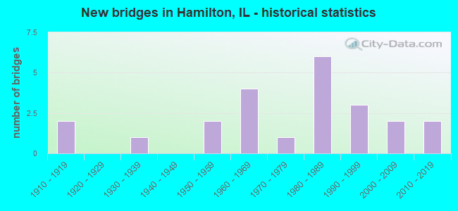
- New bridges - historical statistics
- 21910-1919
- 11930-1939
- 21950-1959
- 41960-1969
- 11970-1979
- 61980-1989
- 31990-1999
- 22000-2009
- 22010-2019

- Reconstructed bridges - Historical Statistics
- 11970-1979
- 11980-1989
- 11990-1999


- Bridge Condition - Deck
- 18.8%Very good
- 31.3%Good
- 18.8%Satisfactory
- 12.5%Fair
- 18.8%Poor

- Bridge Condition - Superstructure
- 22.2%Very good
- 27.8%Good
- 16.7%Satisfactory
- 5.6%Fair
- 27.8%Poor

- Bridge Condition - Substructure
- 22.2%Very good
- 27.8%Good
- 22.2%Satisfactory
- 16.7%Fair
- 11.1%Poor

- Bridge Condition - Channel
- 21.7%Very good
- 17.4%Good
- 26.1%Satisfactory
- 17.4%Fair
- 13.0%Poor
- 4.3%Serious

- Bridge Condition - Culverts
- 20.0%Very good
- 60.0%Good
- 20.0%Fair
Find on map >> Show street view
Structure Number: 340001, Location: .1M E KEOKUK BRIDGE (Lat: 40.389364, Lng: -91.362711), Route carried "on" structure: US 136, Year Built: 1954, Year Reconstructed: 1986, Status: Open, Structure Length: 6.40m (21.00ft), Average Daily Traffic: 11,900 (year 2021), Truck Traffic: 9%, Average Future Daily Traffic: 6,300 (year 2032), Design Load: HS 20, Features Intersected: HAMILTON SLOUGH
Minimum Vertical Clearance: 30+ m (98+ ft), Kilometerpoint: 1.014, Lanes on structure: 2, Base Highway Network: Yes, Owner: State Highway Agency, Approaching Roadway Width: 13.4m (44.0ft), Skew: 33 degrees, Material/Design: Steel continuous, Design/Construction: Stringer/Multi-beam, Number Of Spans In Main Unit: 3, Length of Maximum Span: 24.1m (79.1ft), Curb or Sidewalk Widths: Left: 0.0m, Right: 3.3m (10.8ft), Curb-To-Curb Width: 20.7m (67.9ft), Out-to-Out Width: 26.2m (86.0ft)
Condition: Deck: Good, Superstructure: Good, Substructure: Good, Channel: Good, Operating Rating: 81.6 metric tons, Method Used To Determine Operating Rating: Load Factor (LF) rating reported by rating factor (RF) method using MS18 loading, Inventory Rating: 49.2 metric tons, Method Used To Determine Inventory Rating: Load Factor (LF) rating reported by rating factor (RF) method using MS18 loading, Structural Evaluation: Better than present minimum criteria, Deck Geometry: Superior to present desirable criteria, Waterway Adequacy: Equal to present minimum criteria, Approach Roadway Alignment: Equal to present desirable criteria, Designated Inspection Frequency: Every 24 months, Inspection Date: Febuary 2022, Deck Structure Type: Concrete Cast-file-Place, Wearing Surface/Protective System: Deck Protection: Epoxy Coated Reinforcing
Find on map >> Show street view
Structure Number: 34003, Location: .5M N US136,HAMILTON (Lat: 40.403908, Lng: -91.351975), Route carried "on" structure: State highway 96, Year Built: 1935, Year Reconstructed: 1979, Status: Open, Structure Length: 6.10m (20.01ft), Average Daily Traffic: 2,200 (year 2021), Truck Traffic: 14%, Average Future Daily Traffic: 2,600 (year 2032), Design Load: HS 20, Features Intersected: CHANEY CREEK
Minimum Vertical Clearance: 30+ m (98+ ft), Kilometerpoint: 166.498, Lanes on structure: 2, Base Highway Network: Yes, Owner: State Highway Agency, Approaching Roadway Width: 11.3m (37.1ft), Material/Design: Prestressed concrete, Design/Construction: Stringer/Multi-beam, Number Of Spans In Main Unit: 3, Length of Maximum Span: 24.4m (80.1ft), Curb or Sidewalk Widths: Left: 1.6m (5.2ft), Right: 0.0m, Curb-To-Curb Width: 9.8m (32.2ft), Out-to-Out Width: 11.7m (38.4ft)
Condition: Deck: Good, Superstructure: Fair, Substructure: Satisfactory, Channel: Good, Operating Rating: 65.8 metric tons, Method Used To Determine Operating Rating: Load Factor (LF) rating reported by rating factor (RF) method using MS18 loading, Inventory Rating: 39.5 metric tons, Method Used To Determine Inventory Rating: Load Factor (LF) rating reported by rating factor (RF) method using MS18 loading, Structural Evaluation: Somewhat better than minimum adequacy, Deck Geometry: Meets minimum limits, Waterway Adequacy: Superior to present desirable criteria, Approach Roadway Alignment: Equal to present minimum criteria, Designated Inspection Frequency: Every 24 months, Underwater Inspection Frequency: Every 60 months, Inspection Date: April 2021, Underwater Inspection Date: August 2018, Deck Structure Type: Concrete Cast-file-Place, Wearing Surface/Protective System: Deck Protection: Epoxy Coated Reinforcing
Find on map >> Show street view
Structure Number: 340062, Location: HAMILTN,IL-KEOKUK,IA (Lat: 40.390325, Lng: -91.373886), Route carried "on" structure: US 136, Year Built: 1985, Status: Open, Structure Length: 101.98m (334.58ft), Average Daily Traffic: 11,900 (year 2021), Truck Traffic: 9%, Average Future Daily Traffic: 12,600 (year 2032), Design Load: HS 20, Features Intersected: MISS R/WATER/1ST/RR
Minimum Vertical Clearance: 30+ m (98+ ft), Kilometerpoint: 0.016, Lanes on structure: 4, Base Highway Network: Yes, Owner: State Highway Agency, Approaching Roadway Width: 18.3m (60.0ft), Skew: 30 degrees, Navigation Control: Yes ( Vertical Clearance: 15.8m (51.8ft), Horizontal Clearance: 61.0m (200.1ft)), Material/Design: Steel continuous, Design/Construction: Stringer/Multi-beam, Number Of Spans In Main Unit: 15, Length of Maximum Span: 89.9m (294.9ft), Curb or Sidewalk Widths: Left: 0.0m, Right: 2.6m (8.5ft), Curb-To-Curb Width: 18.9m (62.0ft), Out-to-Out Width: 23.1m (75.8ft)
Condition: Deck: Satisfactory, Superstructure: Good, Substructure: Fair, Channel: Very good, Operating Rating: 56.1 metric tons, Method Used To Determine Operating Rating: Load Factor (LF) rating reported by rating factor (RF) method using MS18 loading, Inventory Rating: 33.4 metric tons, Method Used To Determine Inventory Rating: Load Factor (LF) rating reported by rating factor (RF) method using MS18 loading, Structural Evaluation: Somewhat better than minimum adequacy, Deck Geometry: Equal to present minimum criteria, Underclear: Superior to present desirable criteria, Waterway Adequacy: Equal to present minimum criteria, Approach Roadway Alignment: Equal to present desirable criteria, Designated Inspection Frequency: Every 24 months, Critical Feature Inspection Frequency: Every 24 months, Underwater Inspection Frequency: Every 60 months, Inspection Date: September 2020, Critical Feature Inspection Date: September 2020, Underwater Inspection Date: September 2020, Deck Structure Type: Concrete Cast-file-Place, Wearing Surface/Protective System: Wearing Surface: Other, Deck Protection: Epoxy Coated Reinforcing
Find on map >> Show street view
Structure Number: 340067, Location: 3.1M S US136,HAMILTN (Lat: 40.361433, Lng: -91.358886), Route carried "on" structure: State highway 96, Year Built: 1994, Status: Open, Structure Length: 1.93m (6.33ft), Average Daily Traffic: 1,850 (year 2021), Truck Traffic: 11%, Average Future Daily Traffic: 1,950 (year 2032), Design Load: HS 20, Features Intersected: CRYSTAL CREEK
Minimum Vertical Clearance: 30+ m (98+ ft), Kilometerpoint: 159.707, Lanes on structure: 2, Base Highway Network: Yes, Owner: State Highway Agency, Approaching Roadway Width: 10.3m (33.8ft), Material/Design: Prestressed concrete, Design/Construction: Stringer/Multi-beam, Number Of Spans In Main Unit: 1, Length of Maximum Span: 17.8m (58.4ft), Curb-To-Curb Width: 9.8m (32.2ft), Out-to-Out Width: 10.7m (35.1ft)
Condition: Deck: Very good, Superstructure: Very good, Substructure: Very good, Channel: Very good, Operating Rating: 69.7 metric tons, Method Used To Determine Operating Rating: Load Factor (LF) rating reported by rating factor (RF) method using MS18 loading, Inventory Rating: 40.8 metric tons, Method Used To Determine Inventory Rating: Load Factor (LF) rating reported by rating factor (RF) method using MS18 loading, Structural Evaluation: Equal to present desirable criteria, Deck Geometry: Somewhat better than minimum adequacy, Waterway Adequacy: Superior to present desirable criteria, Approach Roadway Alignment: Equal to present desirable criteria, Designated Inspection Frequency: Every 48 months, Inspection Date: November 2020, Deck Structure Type: Concrete Cast-file-Place, Wearing Surface/Protective System: Deck Protection: Epoxy Coated Reinforcing
Find on map >> Show street view
Structure Number: 340522, Location: .4 M S HAMILTON (Lat: 40.386189, Lng: -91.340517), Route carried "on" structure: State highway 96, Year Built: 2011, Status: Open, Structure Length: 3.51m (11.52ft), Average Daily Traffic: 2,550 (year 2021), Truck Traffic: 14%, Average Future Daily Traffic: 2,750 (year 2032), Design Load: HS 25 or greater, Features Intersected: RAILROAD CR
Minimum Vertical Clearance: 30+ m (98+ ft), Kilometerpoint: 163.569, Lanes on structure: 2, Base Highway Network: Yes, Owner: State Highway Agency, Approaching Roadway Width: 11.0m (36.1ft), Material/Design: Prestressed concrete, Design/Construction: Stringer/Multi-beam, Number Of Spans In Main Unit: 1, Length of Maximum Span: 34.1m (111.9ft), Curb-To-Curb Width: 11.0m (36.1ft), Out-to-Out Width: 11.9m (39.0ft)
Condition: Deck: Very good, Superstructure: Very good, Substructure: Very good, Channel: Very good, Operating Rating: 65.4 metric tons, Method Used To Determine Operating Rating: Load and Resistance Factor Rating (LRFR) rating reported by rating factor(RF) method using HL-93 loadings, Inventory Rating: 50.9 metric tons, Method Used To Determine Inventory Rating: Load and Resistance Factor Rating (LRFR) rating reported by rating factor(RF) method using HL-93 loadings, Structural Evaluation: Equal to present desirable criteria, Deck Geometry: Somewhat better than minimum adequacy, Waterway Adequacy: Superior to present desirable criteria, Approach Roadway Alignment: Equal to present desirable criteria, Designated Inspection Frequency: Every 24 months, Inspection Date: November 2021, Deck Structure Type: Concrete Cast-file-Place, Wearing Surface/Protective System: Deck Protection: Epoxy Coated Reinforcing
Find on map >> Show street view
Structure Number: 342008, Location: .3M S WARSAW SPUR (Lat: 40.355292, Lng: -91.373414), Route carried "on" structure: State highway 96, Year Built: 1994, Status: Open, Structure Length: 0.76m (2.49ft), Average Daily Traffic: 2,000 (year 2021), Truck Traffic: 15%, Average Future Daily Traffic: 1,850 (year 2032), Design Load: HS 20, Features Intersected: GLEN CREEK
Minimum Vertical Clearance: 30+ m (98+ ft), Kilometerpoint: 157.921, Lanes on structure: 2, Base Highway Network: Yes, Owner: State Highway Agency, Approaching Roadway Width: 10.7m (35.1ft), Skew: 2 degrees, Material/Design: Concrete continuous, Design/Construction: Culvert, Number Of Spans In Main Unit: 2, Length of Maximum Span: 3.4m (11.2ft), Out-to-Out Width: 10.7m (35.1ft)
Condition: Channel: Very good, Culverts: Good, Operating Rating: 62.2 metric tons, Method Used To Determine Operating Rating: Load Factor (LF) rating reported by rating factor (RF) method using MS18 loading, Inventory Rating: 37.9 metric tons, Method Used To Determine Inventory Rating: Load Factor (LF) rating reported by rating factor (RF) method using MS18 loading, Structural Evaluation: Better than present minimum criteria, Waterway Adequacy: Superior to present desirable criteria, Approach Roadway Alignment: Equal to present desirable criteria, Designated Inspection Frequency: Every 48 months, Inspection Date: August 2019, Deck Structure Type: Concrete Cast-file-Place
Find on map >> Show street view
Structure Number: 342011, Location: .2M W IL96/E WARSAW (Lat: 40.359503, Lng: -91.376797), Route carried "on" structure: County highway , Year Built: 1995, Status: Open, Structure Length: 1.42m (4.66ft), Average Daily Traffic: 1,100 (year 2018), Truck Traffic: 13%, Average Future Daily Traffic: 1,150 (year 2032), Design Load: HS 20, Features Intersected: GLEN CREEK, Facility Carried by Structure: WARSAW (IL 96) SPU
Minimum Vertical Clearance: 30+ m (98+ ft), Kilometerpoint: 5.279, Lanes on structure: 2, Owner: State Highway Agency, Approaching Roadway Width: 9.8m (32.2ft), Material/Design: Concrete continuous, Design/Construction: Culvert, Number Of Spans In Main Unit: 2, Length of Maximum Span: 6.5m (21.3ft)
Condition: Channel: Good, Culverts: Good, Operating Rating: 44.1 metric tons, Method Used To Determine Operating Rating: Load Factor (LF) rating reported by rating factor (RF) method using MS18 loading, Inventory Rating: 32.4 metric tons, Method Used To Determine Inventory Rating: Load Factor (LF) rating reported by rating factor (RF) method using MS18 loading, Structural Evaluation: Better than present minimum criteria, Waterway Adequacy: Superior to present desirable criteria, Approach Roadway Alignment: Equal to present desirable criteria, Designated Inspection Frequency: Every 48 months, Inspection Date: October 2021
Find on map >> Show street view
Structure Number: 342523, Location: 1.4 M N OF US 136 (Lat: 40.414658, Lng: -91.358206), Route carried "on" structure: State highway 96, Year Built: 2013, Status: Open, Structure Length: 1.30m (4.27ft), Average Daily Traffic: 1,450 (year 2021), Truck Traffic: 12%, Average Future Daily Traffic: 1,250 (year 2032), Features Intersected: DRAINAGE
Minimum Vertical Clearance: 30+ m (98+ ft), Kilometerpoint: 168.091, Lanes on structure: 2, Base Highway Network: Yes, Owner: State Highway Agency, Approaching Roadway Width: 11.0m (36.1ft), Material/Design: Concrete, Design/Construction: Culvert, Number Of Spans In Main Unit: 3, Length of Maximum Span: 3.7m (12.1ft), Curb-To-Curb Width: 14.0m (45.9ft)
Condition: Channel: Very good, Culverts: Very good, Operating Rating: 54.8 metric tons, Method Used To Determine Operating Rating: Load Factor (LF) rating reported by rating factor (RF) method using MS18 loading, Inventory Rating: 42.1 metric tons, Method Used To Determine Inventory Rating: Load Factor (LF) rating reported by rating factor (RF) method using MS18 loading, Structural Evaluation: Equal to present desirable criteria, Deck Geometry: Superior to present desirable criteria, Waterway Adequacy: Superior to present desirable criteria, Approach Roadway Alignment: Equal to present desirable criteria, Designated Inspection Frequency: Every 48 months, Inspection Date: August 2019, Deck Structure Type: Other
Find on map >> Show street view
Structure Number: 343247, Location: 2.0 MI NE HAMILTON (Lat: 40.415447, Lng: -91.310297), Route carried "on" structure: County highway , Year Built: 1986, Status: Open, Structure Length: 2.33m (7.64ft), Average Daily Traffic: 900 (year 2018), Truck Traffic: 14%, Average Future Daily Traffic: 1,450 (year 2032), Design Load: HS 20, Features Intersected: CHANEY CREEK, Facility Carried by Structure: FAS 422
Minimum Vertical Clearance: 30+ m (98+ ft), Kilometerpoint: 15.176, Lanes on structure: 2, Owner: County Highway Agency, Approaching Roadway Width: 6.7m (22.0ft), Material/Design: Prestressed concrete, Design/Construction: Box Beam or Girders - Multiple, Number Of Spans In Main Unit: 1, Length of Maximum Span: 22.9m (75.1ft), Curb-To-Curb Width: 9.2m (30.2ft), Out-to-Out Width: 9.2m (30.2ft)
Condition: Deck: Satisfactory, Superstructure: Satisfactory, Substructure: Good, Channel: Fair, Operating Rating: 69.0 metric tons, Method Used To Determine Operating Rating: Load Factor (LF) rating reported by rating factor (RF) method using MS18 loading, Inventory Rating: 41.1 metric tons, Method Used To Determine Inventory Rating: Load Factor (LF) rating reported by rating factor (RF) method using MS18 loading, Structural Evaluation: Equal to present minimum criteria, Deck Geometry: Equal to present minimum criteria, Waterway Adequacy: Better than present minimum criteria, Approach Roadway Alignment: Equal to present desirable criteria, Designated Inspection Frequency: Every 24 months, Inspection Date: Febuary 2021, Deck Structure Type: Concrete Precast Panels, Wearing Surface/Protective System: Wearing Surface: Bituminous, Membrane: Built-up
Find on map >> Show street view
Structure Number: 343248, Location: 3 M NE HAMILTON (Lat: 40.444833, Lng: -91.309758), Route carried "on" structure: County highway , Year Built: 2009, Status: Open, Structure Length: 0.89m (2.92ft), Average Daily Traffic: 950 (year 2018), Truck Traffic: 17%, Average Future Daily Traffic: 800 (year 2032), Design Load: HS 20, Features Intersected: WAGNER CR, Facility Carried by Structure: FAS 422
Minimum Vertical Clearance: 30+ m (98+ ft), Kilometerpoint: 12.005, Lanes on structure: 2, Owner: County Highway Agency, Approaching Roadway Width: 6.7m (22.0ft), Material/Design: Concrete, Design/Construction: Frame, Number Of Spans In Main Unit: 1, Length of Maximum Span: 8.7m (28.5ft), Curb-To-Curb Width: 6.7m (22.0ft), Out-to-Out Width: 10.4m (34.1ft)
Condition: Superstructure: Very good, Substructure: Good, Channel: Satisfactory, Operating Rating: 53.8 metric tons, Method Used To Determine Operating Rating: Field evaluation and documented engineering judgment, Inventory Rating: 32.4 metric tons, Method Used To Determine Inventory Rating: Field evaluation and documented engineering judgment, Structural Evaluation: Better than present minimum criteria, Deck Geometry: Meets minimum limits, Waterway Adequacy: Equal to present desirable criteria, Approach Roadway Alignment: Equal to present desirable criteria, Designated Inspection Frequency: Every 48 months, Inspection Date: Febuary 2021
Find on map >> Show street view
Structure Number: 343249, Location: 1.5 M NE HAMILTON (Lat: 40.421083, Lng: -91.310236), Route carried "on" structure: County highway , Year Built: 2008, Status: Open, Structure Length: 0.77m (2.53ft), Average Daily Traffic: 900 (year 2018), Truck Traffic: 14%, Average Future Daily Traffic: 1,450 (year 2032), Design Load: HS 20, Features Intersected: TRIB CHANEY CR, Facility Carried by Structure: FAS 422
Minimum Vertical Clearance: 30+ m (98+ ft), Kilometerpoint: 14.500, Lanes on structure: 2, Owner: County Highway Agency, Approaching Roadway Width: 6.7m (22.0ft), Material/Design: Concrete, Design/Construction: Frame, Number Of Spans In Main Unit: 1, Length of Maximum Span: 7.5m (24.6ft), Curb-To-Curb Width: 6.7m (22.0ft), Out-to-Out Width: 10.4m (34.1ft)
Condition: Superstructure: Very good, Substructure: Very good, Channel: Satisfactory, Operating Rating: 53.8 metric tons, Method Used To Determine Operating Rating: Field evaluation and documented engineering judgment, Inventory Rating: 32.4 metric tons, Method Used To Determine Inventory Rating: Field evaluation and documented engineering judgment, Structural Evaluation: Equal to present desirable criteria, Deck Geometry: Meets minimum limits, Waterway Adequacy: Equal to present desirable criteria, Approach Roadway Alignment: Equal to present minimum criteria, Designated Inspection Frequency: Every 48 months, Inspection Date: Febuary 2021
Find on map >> Show street view
Structure Number: 34332, Location: 1 MI E OF WARSAW (Lat: 40.373483, Lng: -91.383544), Route carried "on" structure: County highway , Year Built: 1960, Year Reconstructed: 2003, Status: Open, Structure Length: 4.50m (14.76ft), Average Daily Traffic: 2,300 (year 2018), Truck Traffic: 6%, Average Future Daily Traffic: 2,300 (year 2032), Design Load: HS 20, Features Intersected: CRYSTAL GLEN CREEK, Facility Carried by Structure: CO. HWY. 32
Minimum Vertical Clearance: 30+ m (98+ ft), Kilometerpoint: 2.897, Lanes on structure: 2, Owner: County Highway Agency, Approaching Roadway Width: 7.9m (25.9ft), Material/Design: Steel continuous, Design/Construction: Stringer/Multi-beam, Number Of Spans In Main Unit: 3, Length of Maximum Span: 17.4m (57.1ft), Curb-To-Curb Width: 8.9m (29.2ft), Out-to-Out Width: 9.5m (31.2ft)
Condition: Deck: Good, Superstructure: Good, Substructure: Very good, Channel: Good, Operating Rating: 44.4 metric tons, Method Used To Determine Operating Rating: Load Factor (LF) rating reported by rating factor (RF) method using MS18 loading, Inventory Rating: 32.4 metric tons, Method Used To Determine Inventory Rating: Load Factor (LF) rating reported by rating factor (RF) method using MS18 loading, Structural Evaluation: Better than present minimum criteria, Deck Geometry: Meets minimum limits, Waterway Adequacy: Superior to present desirable criteria, Approach Roadway Alignment: Equal to present desirable criteria, Length Of Structure Improvement: 4.51m (14.80ft), Designated Inspection Frequency: Every 48 months, Inspection Date: January 2021, Bridge Improvement Cost: $238,000, Roadway Improvement Cost: $24,000, Total Project Cost: $357,000, Deck Structure Type: Concrete Cast-file-Place, Wearing Surface/Protective System: Deck Protection: Epoxy Coated Reinforcing
Find on map >> Show street view
Structure Number: 343322, Location: 0.43 MI E OF WARSAW (Lat: 40.372392, Lng: -91.393942), Route carried "on" structure: County highway , Year Built: 1960, Status: Open, Structure Length: 0.85m (2.79ft), Average Daily Traffic: 2,050 (year 2018), Truck Traffic: 6%, Average Future Daily Traffic: 2,200 (year 2032), Design Load: HS 20, Features Intersected: CEDAR GLEN CREEK, Facility Carried by Structure: CO HWY 32
Minimum Vertical Clearance: 30+ m (98+ ft), Kilometerpoint: 3.814, Lanes on structure: 2, Owner: County Highway Agency, Approaching Roadway Width: 6.7m (22.0ft), Material/Design: Concrete continuous, Design/Construction: Culvert, Number Of Spans In Main Unit: 2, Length of Maximum Span: 4.3m (14.1ft)
Condition: Channel: Poor, Culverts: Good, Operating Rating: 53.8 metric tons, Method Used To Determine Operating Rating: Field evaluation and documented engineering judgment, Inventory Rating: 32.4 metric tons, Method Used To Determine Inventory Rating: Field evaluation and documented engineering judgment, Structural Evaluation: Better than present minimum criteria, Waterway Adequacy: Better than present minimum criteria, Approach Roadway Alignment: Equal to present desirable criteria, Designated Inspection Frequency: Every 24 months, Inspection Date: Febuary 2021
Find on map >> Show street view
Structure Number: 3446, Location: 3 MI N OF HAMILTON (Lat: 40.449803, Lng: -91.328989), Route carried "on" structure: County highway , Year Built: 1961, Status: Open, Structure Length: 0.67m (2.20ft), Average Daily Traffic: 200 (year 2018), Truck Traffic: 48%, Average Future Daily Traffic: 325 (year 2032), Design Load: HS 15, Features Intersected: WAGGONER CREEK, Facility Carried by Structure: TR 46
Minimum Vertical Clearance: 30+ m (98+ ft), Kilometerpoint: 11.523, Lanes on structure: 2, Owner: Town or Township Highway Agency, Approaching Roadway Width: 6.7m (22.0ft), Material/Design: Concrete continuous, Design/Construction: Culvert, Number Of Spans In Main Unit: 2, Length of Maximum Span: 3.1m (10.2ft)
Condition: Channel: Fair, Culverts: Fair, Operating Rating: 89.1 metric tons, Method Used To Determine Operating Rating: Load Factor (LF) rating reported by rating factor (RF) method using MS18 loading, Inventory Rating: 89.1 metric tons, Method Used To Determine Inventory Rating: Load Factor (LF) rating reported by rating factor (RF) method using MS18 loading, Structural Evaluation: Somewhat better than minimum adequacy, Waterway Adequacy: Superior to present desirable criteria, Approach Roadway Alignment: Equal to present minimum criteria, Designated Inspection Frequency: Every 24 months, Inspection Date: Febuary 2021
Find on map >> Show street view
Structure Number: 344602, Location: 1 MI N OF HAMILTON (Lat: 40.415303, Lng: -91.329511), Route carried "on" structure: County highway , Year Built: 1956, Status: Open, Structure Length: 2.20m (7.22ft), Average Daily Traffic: 550 (year 2018), Truck Traffic: 5%, Average Future Daily Traffic: 950 (year 2032), Design Load: HS 15, Features Intersected: CHANEY CREEK, Facility Carried by Structure: TR 46
Minimum Vertical Clearance: 30+ m (98+ ft), Kilometerpoint: 15.369, Lanes on structure: 2, Owner: Town or Township Highway Agency, Approaching Roadway Width: 6.7m (22.0ft), Material/Design: Steel continuous, Design/Construction: Stringer/Multi-beam, Number Of Spans In Main Unit: 2, Length of Maximum Span: 9.8m (32.2ft), Curb-To-Curb Width: 6.7m (22.0ft), Out-to-Out Width: 8.0m (26.2ft)
Condition: Deck: Fair, Superstructure: Poor, Substructure: Fair, Channel: Satisfactory, Operating Rating: 50.2 metric tons, Method Used To Determine Operating Rating: Load Factor (LF) rating reported by rating factor (RF) method using MS18 loading, Inventory Rating: 23.7 metric tons, Method Used To Determine Inventory Rating: Load Factor (LF) rating reported by rating factor (RF) method using MS18 loading, Structural Evaluation: Meets minimum limits, Deck Geometry: Meets minimum limits, Waterway Adequacy: Equal to present desirable criteria, Approach Roadway Alignment: Equal to present minimum criteria, Designated Inspection Frequency: Every 24 months, Inspection Date: July 2021, Deck Structure Type: Concrete Cast-file-Place, Wearing Surface/Protective System: Wearing Surface: Bituminous
Find on map >> Show street view
Structure Number: 344609, Location: 2.0 SE HAMILTON (Lat: 40.374861, Lng: -91.312450), Route carried "on" structure: County highway , Year Built: 1983, Status: Open, Structure Length: 0.88m (2.89ft), Average Daily Traffic: 125 (year 2018), Truck Traffic: 10%, Average Future Daily Traffic: 125 (year 2032), Design Load: HS 20, Features Intersected: RAILROAD CREEK, Facility Carried by Structure: TR 58
Minimum Vertical Clearance: 30+ m (98+ ft), Kilometerpoint: 2.350, Lanes on structure: 2, Owner: Town or Township Highway Agency, Approaching Roadway Width: 5.5m (18.0ft), Material/Design: Concrete, Design/Construction: Channel Beam, Number Of Spans In Main Unit: 1, Length of Maximum Span: 8.2m (26.9ft), Curb-To-Curb Width: 8.1m (26.6ft), Out-to-Out Width: 8.1m (26.6ft)
Condition: Deck: Good, Superstructure: Satisfactory, Substructure: Satisfactory, Channel: Satisfactory, Operating Rating: 44.4 metric tons, Method Used To Determine Operating Rating: Assigned rating based on Load Factor Design (LFD) reported by rating factor (RF) using MS18 loading, Inventory Rating: 32.4 metric tons, Method Used To Determine Inventory Rating: Assigned rating based on Load Factor Design (LFD) reported by rating factor (RF) using MS18 loading, Structural Evaluation: Equal to present minimum criteria, Deck Geometry: Somewhat better than minimum adequacy, Waterway Adequacy: Equal to present desirable criteria, Approach Roadway Alignment: Equal to present minimum criteria, Designated Inspection Frequency: Every 24 months, Inspection Date: Febuary 2021, Deck Structure Type: Concrete Precast Panels, Wearing Surface/Protective System: Wearing Surface: Bituminous
Find on map >> Show street view
Structure Number: 345801, Location: 1.5 S HAMILTON (Lat: 40.366639, Lng: -91.361281), Route carried "on" structure: County highway , Year Built: 1981, Status: Open, Structure Length: 1.66m (5.45ft), Average Daily Traffic: 225 (year 2018), Truck Traffic: 20%, Average Future Daily Traffic: 100 (year 2032), Design Load: HS 20, Features Intersected: CRYSTAL GLEN CREEK, Facility Carried by Structure: TR 28
Minimum Vertical Clearance: 30+ m (98+ ft), Kilometerpoint: 1.609, Lanes on structure: 2, Owner: Town or Township Highway Agency, Approaching Roadway Width: 4.6m (15.1ft), Material/Design: Prestressed concrete, Design/Construction: Box Beam or Girders - Multiple, Number Of Spans In Main Unit: 1, Length of Maximum Span: 15.8m (51.8ft), Curb-To-Curb Width: 8.3m (27.2ft), Out-to-Out Width: 8.3m (27.2ft)
Condition: Deck: Good, Superstructure: Good, Substructure: Good, Channel: Fair, Operating Rating: 44.4 metric tons, Method Used To Determine Operating Rating: Assigned rating based on Load Factor Design (LFD) reported by rating factor (RF) using MS18 loading, Inventory Rating: 32.4 metric tons, Method Used To Determine Inventory Rating: Assigned rating based on Load Factor Design (LFD) reported by rating factor (RF) using MS18 loading, Structural Evaluation: Better than present minimum criteria, Deck Geometry: Somewhat better than minimum adequacy, Waterway Adequacy: Equal to present minimum criteria, Approach Roadway Alignment: Equal to present desirable criteria, Designated Inspection Frequency: Every 48 months, Inspection Date: March 2018, Deck Structure Type: Concrete Precast Panels, Wearing Surface/Protective System: Wearing Surface: Gravel
Find on map >> Show street view
Structure Number: 345802, Location: 1.9 MI S HAMILTON (Lat: 40.362872, Lng: -91.361214), Route carried "on" structure: County highway , Year Built: 1914, Status: Posted for load, Structure Length: 0.92m (3.02ft), Average Daily Traffic: 225 (year 2018), Truck Traffic: 20%, Average Future Daily Traffic: 100 (year 2032), Features Intersected: CRYSTAL GLEN CREEK, Facility Carried by Structure: TR 28
Minimum Vertical Clearance: 30+ m (98+ ft), Kilometerpoint: 2.044, Lanes on structure: 1, Owner: Town or Township Highway Agency, Approaching Roadway Width: 4.3m (14.1ft), Material/Design: Concrete, Design/Construction: Slab, Number Of Spans In Main Unit: 2, Length of Maximum Span: 4.4m (14.4ft), Curb-To-Curb Width: 4.9m (16.1ft), Out-to-Out Width: 4.9m (16.1ft)
Condition: Deck: Poor, Superstructure: Poor, Substructure: Poor, Channel: Poor, Operating Rating: 5.8 metric tons, Method Used To Determine Operating Rating: Field evaluation and documented engineering judgment, Inventory Rating: 3.6 metric tons, Method Used To Determine Inventory Rating: Field evaluation and documented engineering judgment, Structural Evaluation: High priority of replacement, Deck Geometry: High priority of replacement, Waterway Adequacy: Meets minimum limits, Approach Roadway Alignment: Equal to present minimum criteria, Bridge Posting: Required (Relationship of Operating Rating to Maximum Legal Load: > 39.9% below), Length Of Structure Improvement: 1.55m (5.09ft), Designated Inspection Frequency: Every 24 months, Other Special Inspection Frequency: Every 12 months, Inspection Date: Febuary 2021, Other Special Inspection Date: Febuary 2021, Bridge Improvement Cost: $45,000, Roadway Improvement Cost: $5,000, Total Project Cost: $68,000, Deck Structure Type: Concrete Cast-file-Place, Wearing Surface/Protective System: Wearing Surface: Gravel
Find on map >> Show street view
Structure Number: 345804, Location: 2.0 S HAMILTON (Lat: 40.362103, Lng: -91.361208), Route carried "on" structure: County highway , Year Built: 1914, Status: Posted for load, Structure Length: 0.92m (3.02ft), Average Daily Traffic: 225 (year 2018), Truck Traffic: 20%, Average Future Daily Traffic: 100 (year 2032), Features Intersected: CRYSTAL GLEN CREEK, Facility Carried by Structure: TR 28
Minimum Vertical Clearance: 30+ m (98+ ft), Kilometerpoint: 2.124, Lanes on structure: 1, Owner: Town or Township Highway Agency, Approaching Roadway Width: 4.3m (14.1ft), Material/Design: Concrete, Design/Construction: Slab, Number Of Spans In Main Unit: 2, Length of Maximum Span: 4.4m (14.4ft), Curb-To-Curb Width: 5.2m (17.1ft), Out-to-Out Width: 5.2m (17.1ft)
Condition: Deck: Poor, Superstructure: Poor, Substructure: Poor, Channel: Fair, Operating Rating: 5.8 metric tons, Method Used To Determine Operating Rating: Field evaluation and documented engineering judgment, Inventory Rating: 3.6 metric tons, Method Used To Determine Inventory Rating: Field evaluation and documented engineering judgment, Structural Evaluation: High priority of replacement, Deck Geometry: High priority of replacement, Waterway Adequacy: Meets minimum limits, Approach Roadway Alignment: Equal to present minimum criteria, Bridge Posting: Required (Relationship of Operating Rating to Maximum Legal Load: > 39.9% below), Length Of Structure Improvement: 1.55m (5.09ft), Designated Inspection Frequency: Every 24 months, Other Special Inspection Frequency: Every 12 months, Inspection Date: Febuary 2021, Other Special Inspection Date: Febuary 2021, Bridge Improvement Cost: $45,000, Roadway Improvement Cost: $5,000, Total Project Cost: $68,000, Deck Structure Type: Concrete Cast-file-Place, Wearing Surface/Protective System: Wearing Surface: Gravel
Find on map >> Show street view
Structure Number: 345811, Location: 2.0 SE HAMILTON (Lat: 40.371481, Lng: -91.315758), Route carried "on" structure: County highway , Year Built: 1980, Status: Open, Structure Length: 0.79m (2.59ft), Average Daily Traffic: 75 (year 2018), Average Future Daily Traffic: 50 (year 2032), Design Load: HS 20+Mod, Features Intersected: RAILROAD CREEK, Facility Carried by Structure: TR 239
Minimum Vertical Clearance: 30+ m (98+ ft), Kilometerpoint: 2.430, Lanes on structure: 2, Owner: Town or Township Highway Agency, Approaching Roadway Width: 4.0m (13.1ft), Material/Design: Prestressed concrete, Design/Construction: Box Beam or Girders - Multiple, Number Of Spans In Main Unit: 1, Length of Maximum Span: 7.6m (24.9ft), Curb-To-Curb Width: 8.3m (27.2ft), Out-to-Out Width: 8.3m (27.2ft)
Condition: Deck: Satisfactory, Superstructure: Satisfactory, Substructure: Fair, Channel: Serious, Operating Rating: 46.0 metric tons, Method Used To Determine Operating Rating: Load Factor (LF) rating reported by rating factor (RF) method using MS18 loading, Inventory Rating: 27.5 metric tons, Method Used To Determine Inventory Rating: Load Factor (LF) rating reported by rating factor (RF) method using MS18 loading, Structural Evaluation: Somewhat better than minimum adequacy, Deck Geometry: Equal to present minimum criteria, Waterway Adequacy: Better than present minimum criteria, Approach Roadway Alignment: Equal to present minimum criteria, Designated Inspection Frequency: Every 24 months, Inspection Date: March 2020, Deck Structure Type: Concrete Precast Panels, Wearing Surface/Protective System: Wearing Surface: Gravel
Find on map >> Show street view
Structure Number: 345838, Location: 2.6 SE HAMILTON (Lat: 40.353278, Lng: -91.351208), Route carried "on" structure: County highway , Year Built: 1984, Status: Open, Structure Length: 1.07m (3.51ft), Average Daily Traffic: 50 (year 2018), Average Future Daily Traffic: 10 (year 2032), Design Load: HS 20, Features Intersected: CRYSTAL CREEK, Facility Carried by Structure: TR 261
Minimum Vertical Clearance: 30+ m (98+ ft), Kilometerpoint: 3.106, Lanes on structure: 2, Owner: Town or Township Highway Agency, Approaching Roadway Width: 3.7m (12.1ft), Material/Design: Concrete, Design/Construction: Channel Beam, Number Of Spans In Main Unit: 1, Length of Maximum Span: 10.4m (34.1ft), Curb-To-Curb Width: 8.1m (26.6ft), Out-to-Out Width: 8.1m (26.6ft)
Condition: Deck: Very good, Superstructure: Good, Substructure: Good, Channel: Satisfactory, Operating Rating: 67.7 metric tons, Method Used To Determine Operating Rating: Load Factor (LF) rating reported by rating factor (RF) method using MS18 loading, Inventory Rating: 40.5 metric tons, Method Used To Determine Inventory Rating: Load Factor (LF) rating reported by rating factor (RF) method using MS18 loading, Structural Evaluation: Better than present minimum criteria, Deck Geometry: Equal to present minimum criteria, Waterway Adequacy: Superior to present desirable criteria, Approach Roadway Alignment: Equal to present minimum criteria, Designated Inspection Frequency: Every 48 months, Inspection Date: April 2018, Deck Structure Type: Concrete Precast Panels, Wearing Surface/Protective System: Wearing Surface: Gravel
Find on map >> Show street view
Structure Number: 346001, Location: IN HAMILTON (Lat: 40.389467, Lng: -91.359736), Route carried "on" structure: County highway , Year Built: 1960, Status: Open, Structure Length: 2.56m (8.40ft), Average Daily Traffic: 3,100 (year 2018), Truck Traffic: 11%, Average Future Daily Traffic: 2,600 (year 2032), Design Load: HS 20, Features Intersected: RAILROAD CREEK, Facility Carried by Structure: FAS 1600
Minimum Vertical Clearance: 30+ m (98+ ft), Kilometerpoint: 0.080, Lanes on structure: 2, Owner: City or Municipal Highway Agency, Approaching Roadway Width: 17.4m (57.1ft), Skew: 30 degrees, Material/Design: Steel continuous, Design/Construction: Stringer/Multi-beam, Number Of Spans In Main Unit: 3, Length of Maximum Span: 9.0m (29.5ft), Curb-To-Curb Width: 11.2m (36.7ft), Out-to-Out Width: 14.7m (48.2ft)
Condition: Deck: Fair, Superstructure: Poor, Substructure: Satisfactory, Channel: Satisfactory, Operating Rating: 78.7 metric tons, Method Used To Determine Operating Rating: Load Factor (LF) rating reported by rating factor (RF) method using MS18 loading, Inventory Rating: 47.0 metric tons, Method Used To Determine Inventory Rating: Load Factor (LF) rating reported by rating factor (RF) method using MS18 loading, Structural Evaluation: Meets minimum limits, Deck Geometry: Somewhat better than minimum adequacy, Waterway Adequacy: Equal to present desirable criteria, Approach Roadway Alignment: Equal to present desirable criteria, Designated Inspection Frequency: Every 24 months, Inspection Date: November 2021, Deck Structure Type: Concrete Cast-file-Place, Wearing Surface/Protective System: Wearing Surface: Bituminous
Find on map >> Show street view
Structure Number: 346002, Location: CITY OF HAMILTON (Lat: 40.389158, Lng: -91.356797), Route carried "on" structure: City street , Year Built: 1974, Status: Open, Structure Length: 1.22m (4.00ft), Average Daily Traffic: 225 (year 2018), Truck Traffic: 7%, Average Future Daily Traffic: 209 (year 2032), Design Load: HS 20, Features Intersected: RAILROAD CREEK, Facility Carried by Structure: 2ND STREET
Minimum Vertical Clearance: 30+ m (98+ ft), Kilometerpoint: 0.338, Lanes on structure: 2, Owner: City or Municipal Highway Agency, Approaching Roadway Width: 5.5m (18.0ft), Skew: 2 degrees, Material/Design: Prestressed concrete, Design/Construction: Box Beam or Girders - Multiple, Number Of Spans In Main Unit: 1, Length of Maximum Span: 11.9m (39.0ft), Curb-To-Curb Width: 7.4m (24.3ft), Out-to-Out Width: 7.4m (24.3ft)
Condition: Deck: Poor, Superstructure: Poor, Substructure: Satisfactory, Channel: Poor, Operating Rating: 42.8 metric tons, Method Used To Determine Operating Rating: Load Factor (LF) rating reported by rating factor (RF) method using MS18 loading, Inventory Rating: 25.6 metric tons, Method Used To Determine Inventory Rating: Load Factor (LF) rating reported by rating factor (RF) method using MS18 loading, Structural Evaluation: Meets minimum limits, Deck Geometry: Somewhat better than minimum adequacy, Waterway Adequacy: Better than present minimum criteria, Approach Roadway Alignment: Equal to present minimum criteria, Designated Inspection Frequency: Every 24 months, Inspection Date: Febuary 2021, Deck Structure Type: Concrete Precast Panels, Wearing Surface/Protective System: Wearing Surface: Gravel